
Actualizacin diaria del incendio Whisky Creek 09 19 2024
Related Incident: Whisky Creek Fire
Publication Type: News
Actualización diaria del incendio Whisky Creek
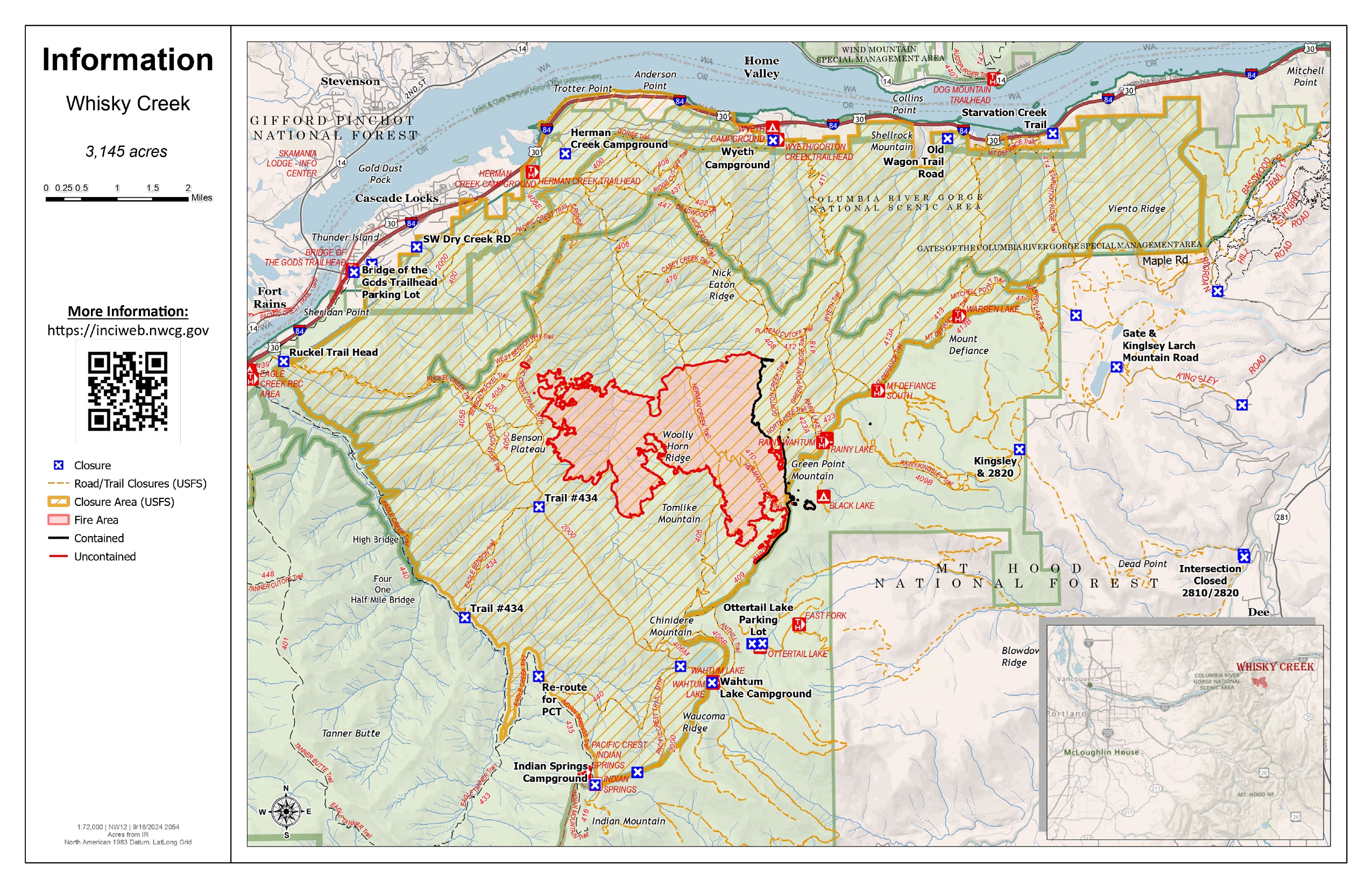
Tamaño de Whisky Creek: 3,145 acres | Fecha de inicio: 20 de julio |Causa: De orígen humano |Contención 25%
Total de recursos: 98 | Equipos de obreros: 3 | Camiones de bomberos: 3 | Camiones de agua: 2 |Maquinarias pesadas: 1
El incendio Whisky Creek se encuentra en un terreno escarpado y escabroso dentro del área de naturaleza Mark O. Hatfield en el Bosque Nacional Mt. Hood. Permanece dentro de las líneas de control a lo largo de los extremos sur y este. La huellas del incendio Eagle Creek continúan como barrera a lo largo de los extremos oeste y norte del incendio.
El crecimiento se ha visto a lo largo del extremo sur del incendio y no representa una amenaza para las líneas de control. Sigue ardiendo entre troncos pesados y continuará produciendo humo ligero. No se espera que empeore la intensidad del fuego aunque el clima en el área se ponga más soleado y cálido.
Ayer, los bomberos comenzaron a desmantelar y remover el sistema de mangueras que alimentaba la línea manual principal que se usó para extinguier el fuego. Una vez que se hay desmantelado, las cuadrillas empaquetarán en mallas de carga que han preparado, y serán transportadas por aire mediante helicóptero, debido al terreno escarpado y escabroso. Además, los asesores de recursos han terminado de explorar el área a lo largo del sendero forestal 409B y comenzarán a repararlo. Este sendero se utilizó como cortafuegos de contingencia durante el trabajo de extinción. Se utilizará una miniexcavadora para reparar este sendero, ya que este es popular en la comunidad de ciclistas de montaña.
Clima: Se desplazará al área una alta presión hoy que resultará en un clima más seco. Veremos un aumento de vientos del oeste, especialmente cerca de las crestas. La recuperación de humedad será alta por la noche con una disminución mínima durante el día. Este patrón de clima debe continuar hasta el viernes.
Para saber el pronóstico de humo y seguridad, consulte: oregonsmoke.org.
Cierres: Los cierres de áreas permanecerán en el Bosque Nacional Mt. Hood, el Área Escénica Nacional Columbia River Gorge y el Condado de Hood River. Se establecen cierres para la seguridad del público y de los bomberos; La intrusión en un área de cierre puede interrumpir las actividades de extinción y reparación de incendios, poner en peligro vidas y propiedades, y puede resultar en multas. La información de cierre se encuentra en: https://linktr.ee/whisky_creek.2024.
Seguridad: El público juega un papel importante en la prevención del próximo incendio forestal; tenga cuidado con cualquier posible fuente de incendio. Para obtener consejos de prevención, consulte: https://keeporegongreen.org. La restricción temporal contra vuelos sigue vigente para el incendio Whisky Creek: https://tinyurl.com/2s49yrj4.
Coffee Pot Daily Update 09 19 2024
Related Incident: Coffee Pot Fire
Publication Type: News
Command: SACIMT2
Fire Size: 14,104
Percent Contained: 93%
Primary Strategic Control Line: 96%
Personnel: 450
Cause: Lightning
Start Date: Saturday, August 3, 2024, at 10:05 a.m.
Location: Southeast of Three Rivers, CA
CURRENT SITUATION: As a low-pressure system approaches, higher relative humidity will continue to minimize fire activity. Wetting rain (0.10 inches or greater) is possible over the fire area. Crews will continue to monitor and mop-up all containment lines. Firefighters will strengthen the line in the Horse Creek area to keep the fire within the current footprint. Crews will continue brushing along the Mineral King Road in order to further strengthen contingency lines. Unneeded equipment will continue to be backhauled from areas of the fire as containment increases. Additional resources will be released in order to rest and become available for other incidents across the nation.
WEATHER: Potential for rainfall increases on Thursday. Temperatures will range from the mid-40s to upper- 50s with a relative humidity ranging from 70% to 90%. A large trough in place over the region will continue an unsettled weather pattern through Thursday resulting in cooler and wetter conditions. A gradual warming and drying trend will begin on Friday as a ridge builds over the west this weekend.
SMOKE IMPACTS: Tomorrow is the last forecast for smoke related to the Coffee Pot Fire. Haze around the fire will be visible during the day. Expect GOOD air quality with some hours of MODERATE in areas closest to the fire. For more information on current wildfire smoke impacts in your community, please visit AirNow.gov or fire.airnow.gov.
EVACUATION NOTICES: Tulare County Fire Department has announced that the evacuation warnings for the following areas have been lifted effective Tuesday, September 17th, 2024: zones TLC-E094-B, TLC-E094-D and TLC-E094-C. The area includes east of River Hill, North of Case Mountain, West of Mitchell Ranch, and the community of Oak Grove. West of the National Park Boundary, North of the east fork of the Kaweah River, East of Oak Grove. The area South of the East Fork of the Kaweah River, approximately ½ mile southeast of Oak Grove, just below mineral King Road, and follows the river east to the southern border of the Genasys zone. north of South Fork Drive, East of Skyline Drive (Salt Creek, fire control road), South of Mineral King Road, and West of the National Park Boundary. To find your zone, please refer to: protect.genasys.com.
FIRE INFORMATION: A Public Information Officer will be at the Three Rivers Village Market daily from 12:00 p.m. to 2:00 p.m. to provide fire information and answer questions.
Whisky Creek Fire update 09 19 2024
Related Incident: Whisky Creek Fire
Publication Type: News
Whisky Creek Fire Update: 9/19/2024
Whisky Creek Size: 3,145 acres | Start Date: July 20 | Cause: Human | Containment: 25%
Total Resources: 98 | Hand Crews: 3 | Engines: 3 | Water Tenders: 2 |Heavy Equipment: 1
The Whisky Creek Fire is in steep and rugged terrain within the Mark O. Hatfield Wilderness in the Mt. Hood National Forest. The fire remains within the control lines along the southern and eastern edge. The Eagle Creek Fire scar continues to be a barrier along the western and northern edges of the fire.
All fire growth has been along the southern edge of the fire and poses no threat to control lines. The fire is still smoldering in heavy logs and will continue to produce light smoke. Fire behavior is not expected to increase even with sunnier, warmer weather moving into the area.
Yesterday, firefighters began to disassemble and remove the hose lay system that fed the primary handline used for fire suppression. Once torn down, crews will package the hose into cargo nets they have prepared which will be airlifted out by a helicopter, given the steep and rugged terrain. In addition, Resource Advisors have finished scouting the area along Forest Trail 409B and will begin work to repair it. This trail was used during fire suppression efforts as a contingency fire line. A mini-excavator will be used to repair this trail which is popular in the mountain bike community.
Weather: High pressure moves into the area today bringing drier weather. We will see an increase in westerly winds mostly up near the ridgetops. Humidity recoveries will be high overnight with minimal decline during the day. This weather pattern should continue through Friday.
For smoke forecasts and safety, visit: oregonsmoke.org.
Closures: Area closures remain in the Mt. Hood National Forest, Columbia River Gorge National Scenic Area, and Hood River County. Closures are put into place for the safety of the public and fire crews; intrusion into a closure area can disrupt fire suppression and repair activities, endanger lives and property, and can result in fines. Closure information is at: https://linktr.ee/whisky_creek.2024.
Safety: The public plays an important role in preventing the next wildfire; please use caution with all potential ignition sources. For prevention tips see: https://keeporegongreen.org. The Temporary Flight Restriction remains in effect for the Whisky Fire: https://tinyurl.com/2s49yrj4.
Operational Video for the Chimney Fire 09 19 2024
Related Incident: Chimney Fire
Publication Type: News
Operational Video for the Chimney Fire
Facebook Link: https://fb.watch/uI4NJtozow/
Bachelor Complex Flat Top and Firestone Fires Update 09 19 2024
Related Incident: Bachelor Complex FiresFlat Top and Firestone Fires
Publication Type: News
Northwest 3 Complex Incident Management Team
Lonnie Click ~ Incident Commander
September 19, 2024
Bachelor Complex, Flat Top and Firestone Fires Update
September 19, 2024
Quick Facts: Bachelor Complex
Size: 11,250 acres
Start Date: Sept 8, 2024
Location: 20 miles SW Bend, OR
Personnel: 526
Containment: 31%
Quick Facts: Firestone & Flat Top Fires
Start Date: Sept 6, 2024
Location: North of Fort Rock, OR
Personnel: 244
Firestone Size: 9,227 acres Containment: 67%
Flat Top Size: 35,783 acres Containment: 40%
There will be a community meeting at 6:00 p.m. on Friday at the Three Rivers School cafeteria in Sunriver.
The Bachelor Complex fires have seen little to no growth over the past several days. Favorable conditions allowed for
successful burnout operations on the southern edge of the Little Lava Fire, further strengthening containment lines.
Fireline construction has been completed for Backside and 911 Fires. These fires will be patrolled by air for the next
several days. Lucky Butte Fire is showing minimal heat and continues to burn itself out. The 846 Fire remains less than
one acre, showing minimal heat and is in patrol status. The northwest corner of the Flat Top Fire and southeast side of
the Firestone Fire have been prepared for strategic burning operations. Crews are waiting for favorable conditions to
implement these firing operations that will better secure containment lines.
Bachelor Complex: Today on the Little Lava Fire, firing operations will continue, adding depth to the indirect line along
the southern perimeter. Mop up and suppression repair work will be ongoing on the west and southwest side of the fire.
Unmanned Aerial System (UAS) will be available for aerial ignition if needed to implement burning operations within the
fire perimeter. Crews will continue to mop up any sources of heat and secure the northern perimeter as they complete
connecting dozer lines to the Edison Trail. Adjacent to Forest Service Road (FSR) 45, mop‐up and patrol is ongoing.
Flat Top Fire: The northwest corner of the Flat Top Fire continues to be prepared for burnout operations. Those
operations will be executed today if the conditions, such as weather and vegetation moisture levels, are favorable. Mopup
along dozer lines north of FSR 22 and along FSR 24 to the south will continue. Wood chipping and suppression repair
work, such as pulling back the berms from dozer lines, is progressing. Patrol efforts along the fire’s edge are ongoing.
Firestone Fire: A small pocket of heat was found near the southern boundary Wednesday and was quickly extinguished.
On the southeast side of the fire, a small area is planned for firing operations to further secure the containment line.
Mop‐up, patrol and suppression repair work continue.
Weather and Fire Behavior: A warming and drying trend will continue into the weekend. Smaller fuels, like grasses and
shrubs will be more receptive to carrying fire. More visible smoke is expected today.
Closures: There are two emergency Fire Closure areas on the Deschutes National Forest. To view the updated closure
orders and maps, visit: https://www.fs.usda.gov/alerts/deschutes/alerts‐notices.
Facebook: https://www.facebook.com/deschutesnationalforest/
InciWeb:
https://inciweb.wildfire.gov/incident‐information/ordef‐bachelor‐complex‐fires
https://inciweb.wildfire.gov/incident‐information/ordef‐flat‐top‐and‐firestone‐fires
YouTube: https://www.youtube.com/@CentralOregonFireInfo?app=desktop
Fire Information Line: (541) 249‐9829, 8:00 a.m. to 8:00 p.m.
Smoke & Air Quality Information: fire.airnow.gov
West and Preacher Fires Update 09 19 2024
Related Incident: 2024 - West Fire - TNF2024 - Preacher Fire - TNF
Publication Type: News
Containment increases on West to 39%
Highlights/Operations: The West fire is now 39% contained. Containment was added across the northeast perimeter and across the east side of the fire to the Control Road. Yesterday firefighters continued ignitions on Milk Ranch Point and to the northwest of Camp Geronimo in the Turkey Springs area. Crews continued finalizing ignition plans for the Control Road and the control line east of Pine.
Today is expected to be another suitable day for ignitions that will achieve the desired result of consuming hazardous fuels and improving the ecosystem. The plan is to apply fire west of the Webber Road, along the Control Road towards the west and off Milk Ranch Point to the west. The timing of these plans will be determined by the fire’s movement and crews are being patient. These ignitions are expected to take multiple days and will likely last through the weekend.
The Preacher Fire is 90% contained. Heavy equipment is working on repair work along the powerline corridor. There continues to be minimal smoke.
Weather: Thursday and Friday will see a continuation of slightly below normal temperatures under a mostly sunny sky. Highs are forecast to be 74 to 80 degrees both days. Winds will be south-southwest 5 to 10 mph with gusts of 15 to 20 mph. Minimum humidity levels will range between 20 and 28%
Safety: A Temporary Flight Restriction (TFR) is in place over the West fire area, which includes uncrewed aircraft systems or drones. Reminder that if you fly we can’t, unauthorized drone flights pose serious risks to firefighter and public safety and the effectiveness of wildfire suppression operations.
Closure: The Tonto National Forest has issued a closure for land surrounding the West Fire, this includes Pine Trailhead.
Evacuations: Pine residence on the east side of SR 87 and east of North Pine Creek Canyon road are in SET status. Geronimo Estates residents near the West Fire are in SET status. An interactive map is available to stay up to date with evacuation levels related to both the West and Preacher Fires.
Receive emergency notifications from Gila County.
Smoke: During ignitions, smoke may settle in low-lying areas overnight. Residents are encouraged to close windows at night to avoid smoke impacts. Talk with your doctor and plan for how to manage your health conditions when it is smoky. Additional resources for how to prepare for wildfire smoke.
For the latest news and information about the Tonto National Forest, follow along on Facebook @TontoNationalForest, ‘X’ (formerly Twitter) @TontoForest or Instagram @tontonationalforest and on the Tonto National Forest website.
Homestead Complex and Lane 1 Fire Daily Update 09 19 2024
Related Incident: Lane 1 Fire
Publication Type: News
Email: 2024.homesteadcomplex@firenet.gov
Fire Information Line: 541-208-7100 (Staffed 8 a.m. to 8 p.m.)
Facebook: https://t.ly/mSLvP
Inciweb: https://t.ly/syeHa
September 19, 2024
Firefighters are using direct and indirect tactics to fully suppress eight fires, totaling approximately 35,682 acres. 745 people are assigned to the Homestead Complex and Lane 1 fires. The Salmon 33 Fire (275 acres), Reynolds Butte Fire (334 acres) and Lost Bucket Fire (34 acres) have all been 100% contained. Two helicopters are supporting crews on the ground, dropping buckets of water as needed.
Crews are improving containment lines across the fire area by reducing fuels through mastication, chipping wood, and hauling fuels to landings away from the fire. There are still many miles of uncontained fire edge. Firefighters are mopping up, widening and strengthening fire lines by extinguishing hot spots and removing fuels. Crews are also clearing and repairing roads impacted by the fires and by fire suppression activities. The goal of these fire suppression and repair efforts is to protect the values at risk: communities and infrastructure; private timber lands; and public resources, including recreation opportunities and fish spawning habitat.
On the Horse Heaven Fire (2,741 acres, 56% containment), crews are starting mastication at the northwest fire edge and continuing to masticate along the 3829 road so that feature can serve as a future control line. Firefighters continue mopping up on the north and east flanks of the fire. Several engines and hose lays are supporting the firefighters by supplying water to the area.
On the Fuller Lake (3,690 acres, 0% containment) and Bullpup (535 acres, 7% containment) fires, a chipper and excavator are working on the 300 road. At the northwest flank, engines are maintaining and rehabilitating pumps to ensure they are ready to work directly at the fire edge. On the west flank, firefighters have placed plumbing around the fingers of the fire and are checking those several times daily. Three masticators are working south on the 3810 road, followed by a crew and chippers. There was minimal smoke at the southeast corner yesterday. Crews are removing snags on the east flank along the 5851 road.
On the No Man Fire (2,090 acres, 44% containment), some interior heat and smoke remain near Chilcoot Mountain. This fire activity is not threatening control lines. Firefighters are mopping up at the southeast fire edge, patrolling the east flank, and chipping along the north flank, working toward the Salmon 33 fire.
On the Lane 1 Fire (25,951 acres, 99% containment) crews are grading parts of the 2328, 900, and Clark Creek roads, with excavators working behind them. They are chipping along the east flank, hauling logs from the Fairview area, reviewing structure protections, repairing roads, and putting water bars across dozer lines.
Closures and fire restrictions: Two closure orders impact every District of the Umpqua National Forest https://t.ly/Mvn6G. The forest is in High Fire Danger with Public Use Restrictions at Level 2 https://t.ly/LI4cd. Tomorrow at 12:01am the forest will move to Moderate Fire Danger and remove all Public Use Restrictions. A Bureau of Land Management (BLM) Roseburg District closure order is in effect for portions of BLM land bordering the Umpqua National Forest closure north of Steamboat https://t.ly/uWX6l. A BLM Northwest Oregon District closure is also in place for an area west of the Lane 1 fire https://t.ly/oW1lG.
Weather: At 3,500 feet elevation, the forecast is warm and dry today with light winds after patchy morning fog. The warming and drying trend will continue through this week, reaching into the 80s on Tuesday, with relative humidity dipping to 28 percent. As fuels dry out, the potential for some fire spread increases. Those living, working or recreating in the area may see additional smoke.
Willamette Complex North Daily Update 09 19 2024
Related Incident: North Willamette Complex
Publication Type: News
Willamette Complex North Update
Boulder Creek, Ore, Linton Creek, 374 and Pyramid Fires
Date: Thursday, September 19, 2024
InciWeb: https://inciweb.wildfire.gov/incident-information/orwif-north-willamette-complex
Willamette Complex North Facebook Page: https://www.facebook.com/profile.php?id=61565845313387
Email:2024.WillametteComplex.North@firenet.gov Information line: 541-208-1262 Hours: 8 a.m. to 8 p.m.
Overview: Hunting season is here! During this hunting season, we would like to wish you the best of luck bagging that big buck or upland bird. All visitors to the Willamette National Forest are reminded that forest closures are still in effect for public and firefighter safety. For more information, please visit https://www.fs.usda.gov/willamette. Today is going to bring warmer, drier weather with highs around 80 and little cloud cover. Fuels may begin to dry but fire behavior is expected to remain slow with smoldering and creeping. Smoke will remain visible on warmer days.
Boulder Creek: 511 acres, 0% contained
Located 5 miles east of McKenzie Bridge. The Boulder Creek Fire continues to be the number one priority on the complex. Firefighters continue to complete a line around the fire. They are locating and mopping up hotspots over 100 feet interior from the line on the flanks of the fire. Crews are still removing fuels and mitigating hazards along Highway 126. In cooperation with ODOT, fire managers are estimating a full reopening in the next several days. Highway 242 remains closed to the public and alternate routes are available.
Ore: 3,475 acres, 76% contained
Located 7 miles northeast of Blue River. Firefighters are focusing efforts on the northwest area they are calling “the donut”. Within “the donut” there remains some unburned fuels and small pockets of fire. Team members are using suppression tactics in this area. On the other sections of the fire, crews have begun suppression repair. They are installing water bars to prevent heavy rain from displacing debris and soil and removing equipment that is no longer needed.
374: 58 acres, 0% contained and Linton Creek: 1,301 acres, 0% contained
Located in the Three Sisters Wilderness. These fires are exhibiting similar behaviors with small amounts of smoke and limited heat on the interior of the fire. The Linton Fire has had some containment lines put in and being held with natural barriers such as rock out cropping and old fires. The 374 Fire has good secondary lines and the fire is being held in place. Taking safety into consideration, smoke jumpers and fire crews are being pulled out of the fires. Both fires are being patrolled by air with the option to reinsert firefighters if the need arises.
Pyramid: 1,311 Acres, 98% contained
East of Middle Santiam Wilderness. Firefighters are finalizing the containment work. Crews continue chipping, mastication, fuel removal and patrolling the lines.
Road Closures: OR 126 is open to one-lane traffic between mileposts 13 and 19.5 (intersection with OR 242). OR 242 remains closed to all traffic between the intersection with OR 126 and the Dee Wright Observatory (mileposts 55 to 75), due to the Linton Creek Fire. Use an alternate route; do not divert onto forest roads to avoid closures.
Check for updates at: https://tripcheck.com/
Willamette National Forest Area Closures: Due to fire activity in the McKenzie River Ranger District, the Linton Creek Fire closure area includes Boulder Creek, 374, Roundtop, as well as other fires on the Middle Fork Ranger District including Young Grasshopper and Lowell Creek Fires. Source: https://www.fs.usda.gov/detail/willamette/alerts-notices/?cid=fseprd552029.
September is Suicide Prevention and Awareness month - Statistically, there is a chance someone you know is suffering from suicidal thoughts or has had them in the past. Suicide is a mental health crisis that affects us all. If you or someone you know is having suicidal thoughts, please seek professional help or call the Suicide and Mental Crisis Lifeline at 988.
Rail Ridge Fire Update September 19 2024 09 19 2024
Related Incident:
Publication Type: News
Rail Ridge Fire Update September 19, 2024
Rail Ridge QuickFacts
Detection Date: Sept 2, 2024
Cause: Lightning
Acres: 162,345
Containment: 50%
Crews: 29
Engines: 64
Dozers: 17
Helicopters: 2 Type 1, 1 Type 2, 1 Type 3
Total resources: 1,182
Phone: 541-208-7111 Email: 2024.railridge@firenet.gov Facebook: Rail Ridge Fire - Oregon 2024
Inciweb: https://inciweb.wildfire.gov/incident-information/orocf-rail-ridge
LinkTree: https://linktr.ee/RailRidgeFire
Closures and Evacuations
Closures: The U.S. Forest Service and Bureau of Land Management have implemented partial closures because of the Rail Ridge and Crazy Creek fires, for all uses. For more details and closure maps, visit the Ochoco National Forest, Malheur National Forest, and BLM web pages.
Evacuations: Grant County evacuations were downgraded Wednesday. For up-to-date evacuation information, please visit:
- Grant County: Emergency Management Facebook page.
- Crook County: Emergency Management website; Sheriff’s Office Facebook page.
- Wheeler County: Sheriff’s Office Facebook page.
Operational Update
Today is the final day California Interagency Incident Management Team 10 will be in command of the Rail Ridge Fire. Alaska Incident Management Team 3 is shadowing today and will assume command tomorrow.
Firefighters on the north and northeast sides will take advantage of the continued favorable conditions and focus on strengthening existing suppression lines and completing new ones, including working on shaded fuel breaks and clearing fuels.
On the east side between Shake Table and Forest Service Road 21, crews will continue to work on road repair, grading roads, and repairing the impacts of suppression efforts where needed. On the southern and southeastern portions, crews will monitor and patrol for any heat sources and implement suppression repair.
Throughout the fire area, firefighters will continue mop up efforts, going deeper inside fire lines to eliminate residual heat as large logs and dead, downed trees continue to burn.
Weather
Seasonably warm and dry weather is forecast for the area with lower humidity (25-30%) and sunny skies. Wind will be generally light with gusts up to 15 mph on the ridge tops.
These conditions will allow heavy fuels to continue to burn which will result in slightly increased smoke production but there remains no threat to containment lines.
Short Draw Fire Daily Update 09 19 2024
Related Incident:
Publication Type: News
Key Messages
Fire managers will verify and ensure the fire is 100% contained and controlled by end of day Friday, September 20, through ongoing mop-up activities. The fire is currently 92% contained, with secure fire lines established around most of the perimeter. Extra resources have been demobilized or redirected to other priority incidents.
Current Status
On Wednesday night and throughout the day on Thursday, the fire area received 0.29 inches of rain. While the rainfall aided suppression efforts by extinguishing embers and reducing heat sources. The rainfall also created wet and muddy conditions that temporarily slowed the crews' making it challenging to access certain areas of the fire perimeter. As conditions dry out today, crews will continue to patrol, monitor, and mop up any residual heat within the fire’s interior, extending them by an additional 200 feet into the fire's perimeter to further secure the area. Excavators, dozers, and road graders are in the process of repairing and rehabilitating contingency lines that were previously constructed. This restoration work is crucial to minimizing the long-term environmental impact and helping to return the landscape to its natural state.
Weather and Fire Behavior
Strong westerly winds in the morning from 20-40 mph will slow throughout the day. Temperatures are expected to be in the 70s. The next few days are expected to be calm with clear skies with little chance of rain. Friday afternoon will bring winds out of the north.
Evacuations And Closures
Please avoid the fire area as crews and aerial resources continue fire suppression efforts. The roads remain closed to non-local traffic. Ensuring firefighter safety and protecting life and preservation of grazing lands are most important.
The temporary flight restriction (TFR) over the fire area has been lifted.