
Road Closures 09 21 2024
Related Incident: Bridge Fire
Publication Type: Closures
- Eastbound Big Pines Highway at Largo Vista Road (residents only)
- Big Rock Creek Road at Fenner Canyon Road
- Mescal Creek Road at Mescal Canyon Road
- SR-39 at the base of San Gabriel Canyon (residents only)
- Glendora Mountain Road north of Big Dalton Canyon Road
- Glendora Ridge Road from Mt. Baldy to Glendora Mountain Road
- SR-2 at SR-39
- SR-2 Flume Canyon Road westbound
Additional closures may still be in place on roads managed and maintained by other agencies inside the forest. Most major roads in the Angeles National Forest are not managed or maintained by the Forest Service. We recommend also checking CALTRANS (https://roads.dot.ca.gov/), the Los Angeles County Road Closures list (https://dpw.lacounty.gov/roadclosures/) and the San Bernardino County Road Conditions (https://dpw.sbcounty.gov/operations/road-closures/) list for updates.
Davis Fire Update 09 20 2024
Related Incident: Davis Fire
Publication Type: News
The Southwest Area Incident Management Team 1 transferred command of the Davis Fire to a local Type 4 organization. The local Type 4 organization, led by Incident Commander James Smith, is primarily comprised of local resources from the Humboldt-Toiyabe National Forest, Truckee Meadows Fire Protection District and Nevada Division of Forestry. Fire crews continue to look for heat, mop up hot spots, and patrol containment lines. Additionally, ground resources continue with suppression repair.
The Humboldt-Toiyabe National Forest further decreased the emergency area closure on the Davis Fire. Any National Forest System lands within the fire footprint remains closed. This includes Forest Service roads 41040, 41041, and 41727, as well as the Ophir Creek Trail. Additionally, Washoe County Parks and Recreation has closed the Browns Trail. For more details, please refer to the Emergency Fire Closure document and map at: https://www.fs.usda.gov/alerts/htnf/alerts-notices/?aid=90526.
A Forest Service Burned Area Emergency Response (BAER) team has been established by the Humboldt-Toiyabe National Forest to begin a burned area assessment of National Forest System lands affected by the Davis Fire. The team will share their findings with local agencies to assist them with their analysis of impacted private and county lands. For more information on the BAER response for the Davis Fire, visit: https://inciweb.wildfire.gov/incident-information/nvhtf-davis-fire-burned-area-emergency-response-baer.
Updates or additional information will be posted when needed on the Davis Fire InciWeb page and Facebook and X sites belonging to the Humboldt-Toiyabe National Forest and Truckee Meadows Fire & Rescue. The fire information phone and email are no longer staffed, but questions can still be directed to the Humboldt-Toiyabe National Forest’s Carson Ranger District at 775-882-2766 or Truckee Meadows Fire & Rescue at 775-326-6000 or info@TMFPD.us.
Fire Information
- Acres: 5,824
- Location: Washoe Valley south of Reno, Nevada
- Start Date: Sept. 7, 2024
- Cause: Under Investigation
- Containment: 92%
Fire Information (#DavisFire)
- Inciweb
- Humboldt-Toiyabe National Forest
- Truckee Meadows Fire Protection District
Swauk Creek Fire Update 09 21 2024
Related Incident:
Publication Type: News
Swauk Creek Fire
September 21, 2024
Estimated size: 348 acres
Containment: 58%
Start Date/Time: 9/8/2024 at 3:54 PM
Area of Origin: Adjacent to Highway 97, 14 miles east of Cle Elum, WA
Cause: Human
Structures Damaged: 0
Update: Overnight, crews completed their last evening of night shift. Crews monitored the fire lines, watching for anything smoking or smoldering. There has been no change in the perimeter of the fire.
Today, crews continue to improve containment lines around the fire’s perimeter, concentrating on the north and northeastern flanks. Throughout the dayshift, firefighters will evaluate for hazards such as trees that could fall across the line causing the fire to spread outside control lines. On the west and south of the fire, crews continue to look for hot spots and mop up as needed.
Transition continues with the incoming Type 4 incident commanders from the Okanogan-Wenatchee National Forest - Cle Elum Ranger District and the WA Department of Natural Resources – Southeast Region Kittitas County Unit. Shadowing the current Southeast Washington Type 3 Incident Management Team today helps with a smooth and steady transition, as the outgoing team prepares to head back to their home units tomorrow afternoon. The local teams will stay and mop-up, patrol, and complete repair to areas as needed until the fire is 100 percent contained.
Smoke: While the interior burn area continues to consume dry and downed fuels, smoke impacts from this will be limited to the immediate area.
Forest Closures: The Okanogan-Wenatchee National Forest has area, road, and trail closures due to the Swauk Creek Fire. For a detailed list of closures, including a map of the closure area, please visit the Okanogan-Wenatchee National Forest Website at https://www.fs.usda.gov/alerts/okawen/alerts-notices/?aid=90533.
Road Closures: Highway 97 remains open. Fire vehicle traffic will still be traveling in and out of the area, we ask that people drive using caution.
Weather: A flat ridge of high pressure returns today, which will keep winds across all divisions of the fire at less than 10 mph. Mostly sunny conditions will have temperatures rebounding from the early morning 40s, to nearly 70 degrees by the afternoon. The air mass will remain dry with afternoon humidity values between 25-30%. Relative humidity levels will raise overnight as scattered high clouds, light winds, and cool temperatures return.
Evacuation Levels: There are only Level 1 (Be Fire Aware) evacuations in place. These can be found on the interactive map. Many Forest Service roads are affected in this area; please review the map if you want to know about a specific location/road. Live map of active fires from Kittitas County:
https://kitcogis.maps.arcgis.com/.../minima.../index.html...
The First Creek area is currently closed to the public.
As always, conditions can change quickly; please stay alert and avoid the area if you feel unsafe.
Updated Closure of Bridge Fire Area for Safety 10 19 2024
Related Incident: Bridge Fire
Publication Type: News
Date(s): Oct 17, 2024
Forest Order: 05-01-24-11
The Angeles National Forest has issued an updated Bridge Fire Area Closure Order in effect from October 18, 2024, through December 31, 2025. This closure order covers only National Forest System roads, trails, and other facilities impacted by the Bridge Fire within the Angeles National Forest. This forest order replaces the prior forest order from September 21, 2024 - December 31, 2025.
These areas will be closed for public safety and to facilitate recovery of the natural resources and landscape affected by this wildfire. Closures will include some recreational sites in the Mt. Baldy, Wrightwood, East Fork, and other areas of the forest. For a full description of the closure area, see the attached closure order and maps below.
NOTE: Additional closures may still be in place on roads managed and maintained by other agencies inside the forest. Most major roads in the Angeles National Forest are not managed or maintained by the USDA Forest Service, but instead by:
- CALTRANS Road Information (e.g., Angeles Crest Hwy—State Route. 2, State Route 39)
- Los Angeles County Road Closures (Bouquet Canyon Rd, San Francisquito Rd, Mt. Wilson Rd, etc.)
- San Bernardino County Road Conditions (Mt. Baldy area, some roads in Wrightwood)
- And cities
The following is prohibited within the Angeles National Forest and San Gabriel Mountains National Monument:
- Going into or being upon National Forest System lands within the Bridge Fire Closure Area as described in Exhibit A and shown on Exhibit B.
- Being on any National Forest System Road within the Bridge Fire Closure Area as described in Exhibit A and shown on Exhibit B.
- Being on any National Forest System Trail within the Bridge Fire Closure Area as described in Exhibit A and shown on Exhibit B.
Pursuant to 36 C.F.R. § 261.50(e), the following persons are exempt from this Order:
- Owners, lessees, or residents of private land within the Bridge Fire Closure Area, to the extent necessary to access their land, unless the area is under evacuation order by the County Sheriff or California Office of Emergency Management.
- Any Federal, State, or local government official, government contractor, or member of an organized rescue or firefighting force in the performance of an official duty.
- Persons with Forest Service Permit No. FS-7700-48 (Permit for Use of Roads, Trails, or Areas Restricted by Regulation or Order), specifically exempting them from this Order.
These prohibitions are in addition to the general prohibitions in 36 C.F.R. Part 261, Subpart A.
See attached information for Exhibit A/B and more details.
Attachments:
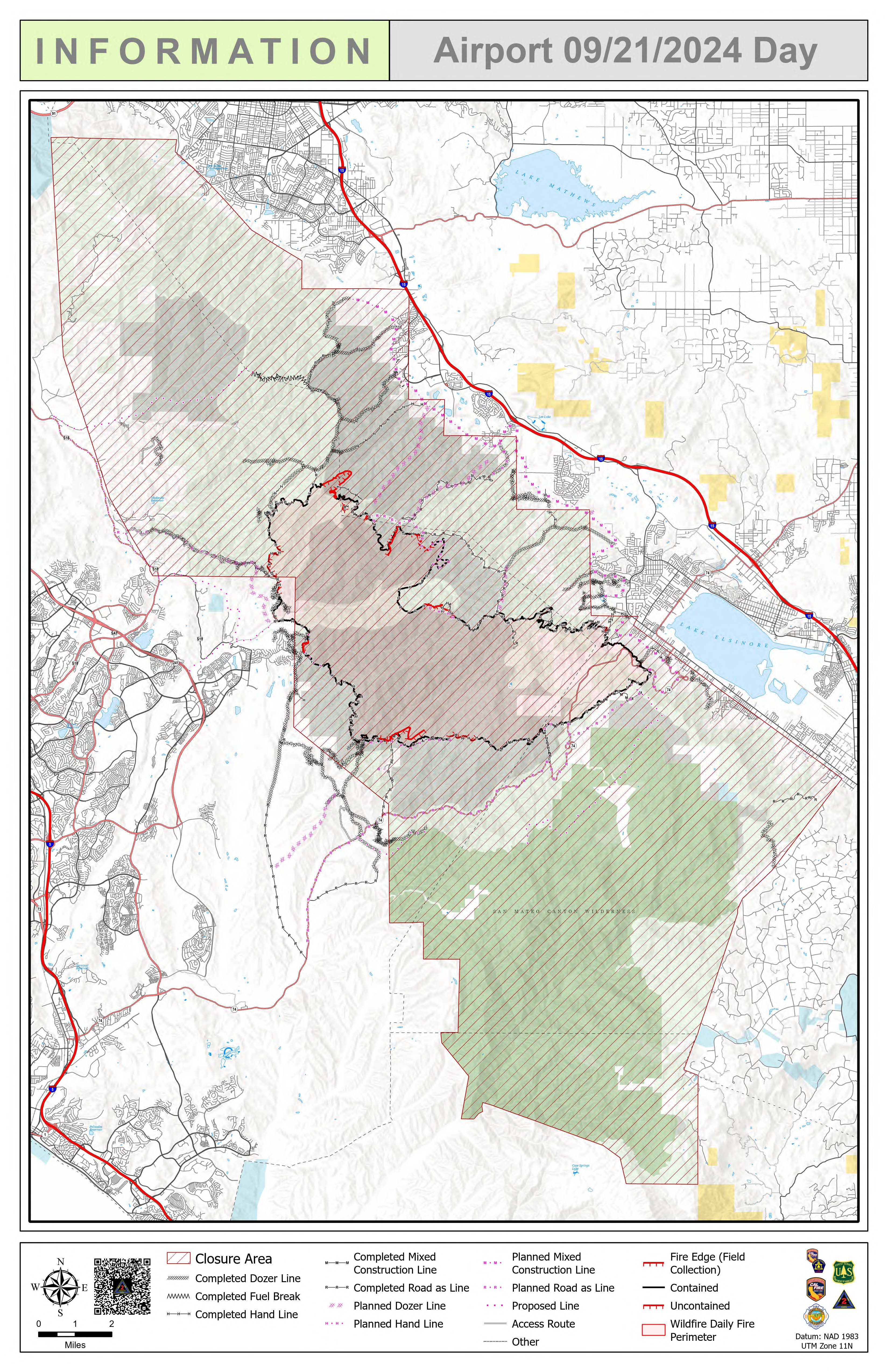
Airport Fire Incident Update 09 21 2024
Related Incident:
Publication Type: News
Location: Trabuco Canyon, CA
Personnel: 1506
Start date: 09/09/24 1:00 p.m.
Cause: Human
Size: 23,519
Percent contained: 62%
For a printable version of today's complete update for the Airport Fire, please see the related link below.
Firefighters continue the operational tempo tying in short sections of line in areas with difficult terrain. In coming days, a continuous fire break should be around the perimeter. Drone modules with infrared sensors are being used in conjunction with ground crews to identify any areas that may be retaining heat.
Information from drone flights is transferred electronically and reproduced on maps that show areas of concern so that firefighting operations may be adapted to address them.
Continued progress has prompted release of some crews in an attempt to “right size” the operation and allow resources to be available for needs elsewhere. Approximately five hundred firefighters were made available at the end of shift last night.
Suppression repair crews are coming in behind firefighters to install anti-erosion features such as water bars as well as identifying other landscape repair needs.
A warming trend today is expected to continue through the weekend into Monday.

Buck Creek Fire Update 09 21 2024
Related Incident: Buck Creek Fire
Publication Type: News
(Silver Lake, Ore.) – The Buck Creek Fire started in heavy timber within the Yamsay Mountain Semi-Primitive Area on the Fremont-Winema National Forest, about 13 miles southwest of Silver Lake, Ore. The fire spread north and east into managed timber stands on National Forest lands with brush and grass understory and remains about 11 miles from the community of Silver Lake. Although the late summer weather may contribute to an increase in fire activity, the fire remains within established containment lines as firefighters continue their work to further strengthen these barriers to fire spread.
Buck Creek: Yesterday, UAS (an Unstaffed Aerial System or drone) with infrared technology identified more heat along the eastern fire line and firefighters immediately engaged to extinguish these hot spots. Elsewhere, mop up efforts were concentrated along the southern fire edge, northwest of Horse Antler Camp, where dense pockets of unburned fuel remain in areas of lingering heat. This can make effective mop up difficult and time consuming. Falling crews worked to take down hazardous trees along the west edge of the fire. Road grading continued on the southeastern portions of the fire. Equipment backhaul was ongoing. Overnight, a crew patrolled the perimeter to ensure fire did not cross constructed fire lines.
Today, most activities will continue from the previous day. UAS missions will search for hot spots near the established fire line; crews will mop up and patrol to ensure the line remains secure. Equipment operators will work on restoring roads around the fire including portions of Forest Road 036. Firefighters will continue backhauling. Helicopters are available to assist on-the-ground crews as needed.
Weather: Today, conditions are similar to yesterday with temperatures in the mid-70s and very low humidity in the high teens. Light winds will be terrain driven with ridgetop gusts up to 15 mph.
Safety: Firefighting equipment and personnel are present on local roads. For the safety of firefighters and the public, fire managers ask the public to drive carefully and remain clear of the fire areas. The public also plays an important role in preventing the next wildfire by using caution with all ignition sources. For fire prevention tips, visit: https://keeporegongreen.org.
Closures and Restrictions: Fire danger remains high. Campfire and other restrictions are in place within the Fremont-Winema National Forest. A forest closure order is in effect for the area around the Buck Creek Fire. For the complete order and map as well as more detail on fire restrictions, go to: https://www.fs.usda.gov/fremont-winema. Christmas Valley Airport is being used as the helibase for fire operations and is temporarily closed to general aviation. A temporary flight restriction is in place over the Buck Creek Fire.
Smoke: Smoke from fires around the region may affect air quality. For more information on conditions and strategies on limiting exposure, go to: www.oregonsmoke.org or www.AirNow.gov.
Bachelor Complex Flat Top and Firestone Fires Update 09 21 2024
Related Incident: Bachelor Complex FiresFlat Top and Firestone Fires
Publication Type: News
Northwest 3 Complex Incident Management Team
Lonnie Click ~ Incident Commander
September 21, 2024
Bachelor Complex, Flat Top and Firestone Fires Update
September 21, 2024
Quick Facts: Bachelor Complex
Size: 11,669 acres
Start Date: Sept 8, 2024
Location: 20 miles SW Bend, OR
Personnel: 410
Containment: 41%
Quick Facts: Firestone & Flat Top Fires
Start Date: Sept 6, 2024
Location: North of Fort Rock, OR
Personnel: 136
Firestone Size: 9,454 acres
Containment: 86%
Flat Top Size: 36,288 acres
Containment: 87%
Yesterday the Bachelor Complex, Flat Top and Firestone Fires experienced warm, dry and breezy conditions,
contributing to increased consumption of fuels within the fire perimeter. While this resulted in increased smoke
production across the area, it also strengthened containment lines by reducing available vegetation between the main
front of the fire and containment lines. Lucky Butte, 911, 846 and Backside Fires were monitored by air. Fire 846 in the
Kwohl Butte area is about three acres. It showed increased activity yesterday so a crew of eight rappellers were inserted
late in the day.
Bachelor Complex: Small strategic burning operations took place on Little Lava Fire yesterday to remove internal
pockets of unburned fuels near control lines. These strategic firing operations were implemented using an Unstaffed
Aerial System (UAS), commonly known as a drone, to start the ignition. Firefighters worked the northern edge of the fire
making progress towards the Edison Trail 3. Along Forest Service Road 45, firefighters started dismantling hose lays,
backhauling truckloads of firehose. Suppression repair work is ongoing, and firefighters will patrol and mop up any
sources of heat found along control lines, as well as backhauling more hose from the fireline.
Flat Top Fire: On the northwest corner of the Flat Top Fire a burnout operation was completed to secure the remaining
open control line on the fire. In the northwest area of the fire, south of the South Lava Trailhead, an engine and dozer
provided structure protection for recreation infrastructure. Today, crews will continue mopping-up, chipping brush and
doing suppression repair as needed. Firefighters will continue to mop up to strengthen containment lines around the
perimeter of the fire.
Firestone Fire: Mop-up continued yesterday on the Firestone Fire. Firefighters continued working in the area of the
burnout along Forest Service Road 100 adding depth to strengthen the effectiveness of control lines. Today’s plan for
the Firestone Fire is to continue mop-up, patrol, chipping and suppression repair where needed.
Weather and Fire Behavior: Warm and dry conditions continue. Low humidity recovery overnight and dry daytime
airmass will result in another early start to the burn period today, with several hours of active burning starting mid-day.
The threat of isolated torching will diminish daily as there is less heat present under the tree canopy in the interior of
the fire and adjacent to containment lines.
Closures: While evacuations have been lifted, there are two temporary emergency fire closure areas on the Deschutes
National Forest. To view the updated closure orders and maps, visit: https://www.fs.usda.gov/alerts/deschutes/alertsnotices.
Facebook: https://www.facebook.com/deschutesnationalforest/
InciWeb:
inciweb.wildfire.gov/incident-information/ordef-bachelor-complex-fires
inciweb.wildfire.gov/incident-information/ordef-flat-top-and-firestone-fires
YouTube: youtube.com/@CentralOregonFireInfo?app=desktop
Fire Information Line: (541) 249-9829, 8:00 a.m. to 8:00 p.m.
Smoke & Air Quality Information: fire.airnow.gov
Red Fire Daily Update for Saturday 09 21 2024
Related Incident: Red Fire
Publication Type: News
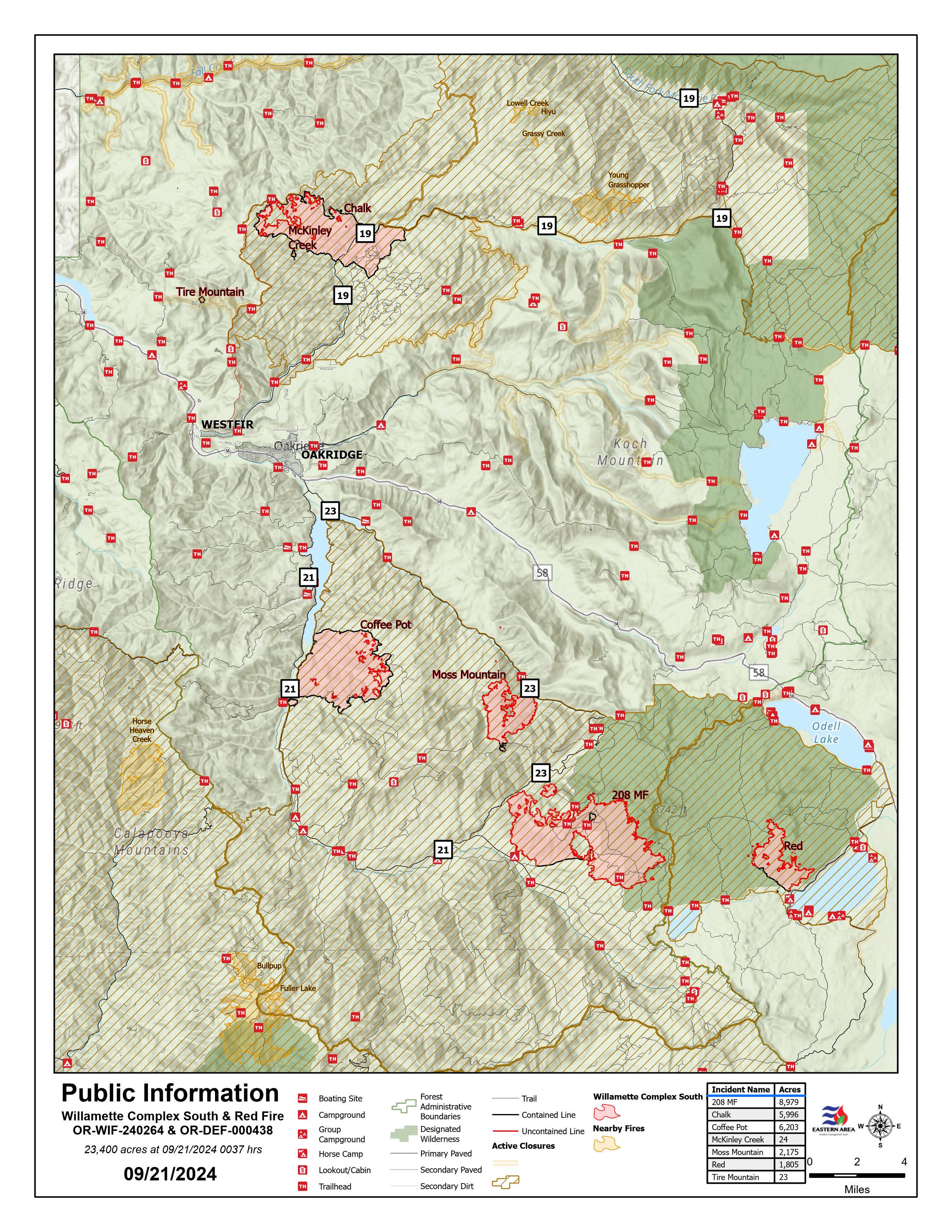
Willamette Complex South & Red Fire Update
Red, 208, Moss Mountain, Coffee Pot, Tire Mountain, McKinley Creek and Chalk Fires
Date: Saturday, September 21, 2024
Fire Causes: Lightning
Email: 2024.willamettecomplex@firenet.gov
Information Phone Line: 541-208-1742
Willamette Complex South: Total Personnel: 436 | Total Willamette Complex South Acres: 23,389
InciWeb: https://inciweb.wildfire.gov/incident-information/orwif-willamette-complex-fires-south
Facebook: https://www.facebook.com/WillametteComplexFires/
Red Fire: Total Personnel: 50 | Total Red Fire Acres: 1,769
InciWeb: https://inciweb.wildfire.gov/incident-information/ordef-red-fire
Facebook: https://www.facebook.com/2024RedFireOR/
Summary
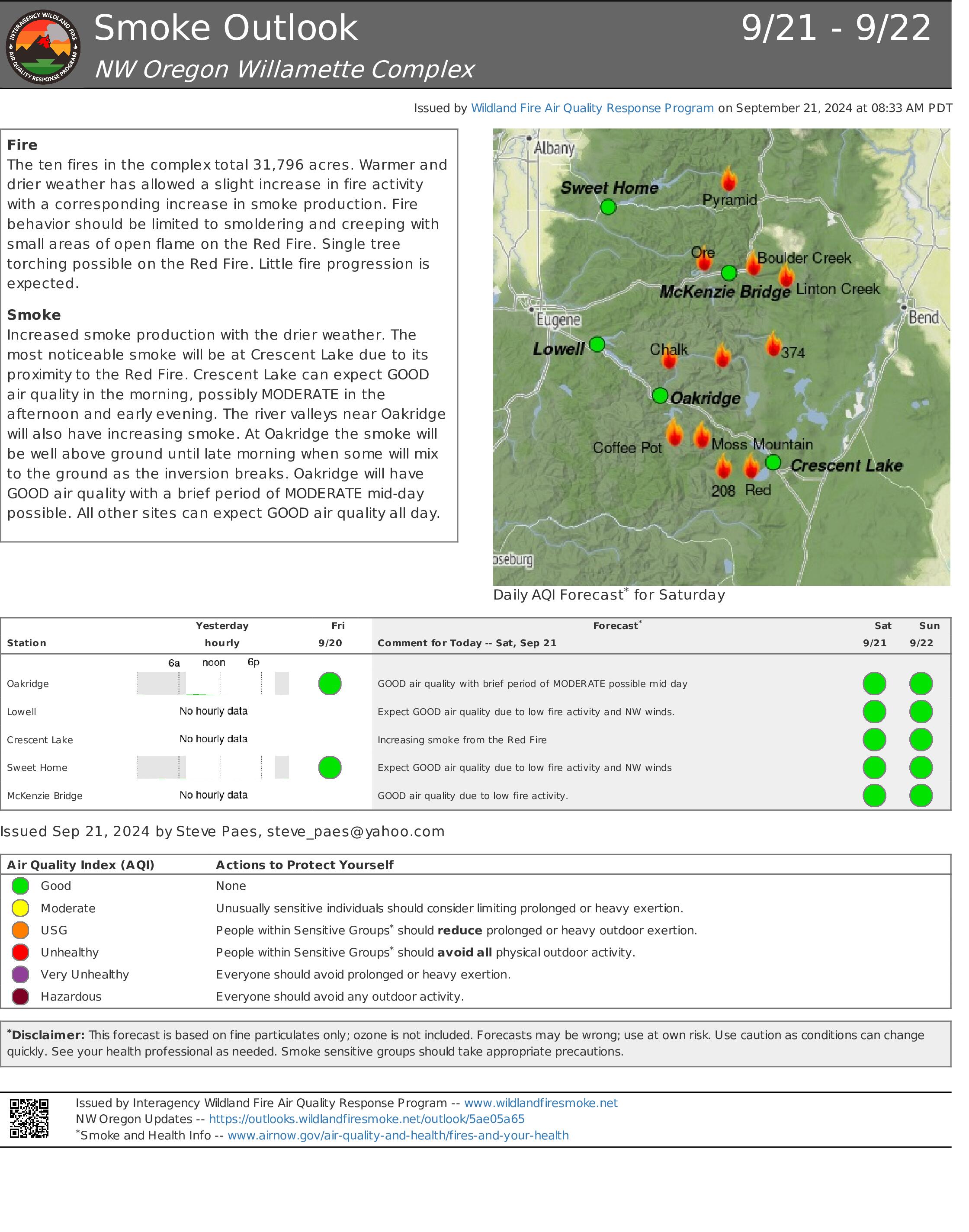
Fire growth continues to be minimal and remains within the established perimeters. While yesterday’s passing cool front helped keep things in check, the warmer, drier air trending into the days ahead may affect fire behavior and necessitate close monitoring into next week. The accumulating conifer needle-drop may fuel smoldering fires, and night-time “recovery” may moderate. Crews continue working to firm up indirect control lines and repair resources in places impacted by suppression operations.
The Chalk Fire, Coffee Pot Fire, McKinley Creek Fire, and Tire Mountain Fire retain their status as 100% contained and are in monitor-and-patrol phase. Crews are chipping, clearing brush and fireline construction materials, and repairing roads impacted by fire suppression activities. Tasks are prioritized under the advisement of resource specialists to ensure repairs and restoration are effective, scientifically sound, and protect sensitive terrain and vegetation as much as possible. Members of the public are asked to continue respecting area closures and restrictions.
Red Fire (1,769 acres, 11% containment)
The Red Fire is now 11% contained, a marked improvement, but there is the potential for fire behavior to change. Hauling and removal of slash from Forest Service Road (FSR) 6010 from Summit Lake to the southwestern corner of Crescent Lake remains a priority. Road repairs and clean-up of the shaded fuel break from Whitefish Horse Camp to Crescent Lake Sno-Park continue. Structure protection measures including portable tanks, hoses, and pumps will remain in place, given the warmer, drier weather in the most recent forecast. Fire growth remains minimal, moderately paced, and concentrated on the southeast perimeter of the fire.
208 Fire (8,969 acres, 4% containment)
Crews observed spotty smoke near the northwest corner and will continue improving holding lines from Lighthouse Rock to Summit Lake. Road repair and material chipping operations are ongoing from Campers Flat to Emigrant Butte along FSR 21. Expect heavy equipment traffic in the area.
Moss Mountain Fire (2,174 acres, 10% containment)
Slash and excess vegetation removal along primary lines northeast of Groundhog Mountain is nearing completion. Crews are making progress south of Beach Mountain near FSR 2316 and expect to connect to the existing fire-line along FSR 23 from the 208 Fire. Crews are identifying critical values at risk near the top of the mountain.
Weather and Fire Behavior
A weak cold front moved through yesterday, briefly increasing the relative humidity by 5-10%, but the expected warming trend that will usher in higher temperatures will also bring a reduction in humidity levels until another front arrives mid- to late-week. Temperatures will return to seasonal averages, with lows in the 40s and highs in the mid-60s but may spike next Tuesday or Wednesday. Expect light northwest winds and drop minimum relative humidity levels to 20 – 30%. Heavy fuels have been burning out but smoldering and creeping continue.
Closures, Fire Restrictions, and Evacuations
- For closure information, visit: https://tinyurl.com/RedFireClosures2024 & https://tinyurl.com/WillFireClosures2024.
- For fire restrictions, visit: https://tinyurl.com/DesFireRestrictions2024 & https://tinyurl.com/WillFireRestrictions2024.
- The Level 1 – BE READY to Evacuate notice remains in effect for the Red Fire. For more information or to sign up for alerts, visit: www.klamathcounty.org/300/emergency-management.
Willamette Complex South Daily Update for Saturday 09 21 2024
Related Incident: Willamette Complex Fires - South
Publication Type: News
Willamette Complex South & Red Fire Update
Red, 208, Moss Mountain, Coffee Pot, Tire Mountain, McKinley Creek and Chalk Fires
Date: Saturday, September 21, 2024
Fire Causes: Lightning
Email: 2024.willamettecomplex@firenet.gov
Information Phone Line: 541-208-1742
Willamette Complex South: Total Personnel: 436 | Total Willamette Complex South Acres: 23,389
InciWeb: https://inciweb.wildfire.gov/incident-information/orwif-willamette-complex-fires-south
Facebook: https://www.facebook.com/WillametteComplexFires/
Red Fire: Total Personnel: 50 | Total Red Fire Acres: 1,769
InciWeb: https://inciweb.wildfire.gov/incident-information/ordef-red-fire
Facebook: https://www.facebook.com/2024RedFireOR/
Summary
Fire growth continues to be minimal and remains within the established perimeters. While yesterday’s passing cool front helped keep things in check, the warmer, drier air trending into the days ahead may affect fire behavior and necessitate close monitoring into next week. The accumulating conifer needle-drop may fuel smoldering fires, and night-time “recovery” may moderate. Crews continue working to firm up indirect control lines and repair resources in places impacted by suppression operations.
The Chalk Fire, Coffee Pot Fire, McKinley Creek Fire, and Tire Mountain Fire retain their status as 100% contained and are in monitor-and-patrol phase. Crews are chipping, clearing brush and fireline construction materials, and repairing roads impacted by fire suppression activities. Tasks are prioritized under the advisement of resource specialists to ensure repairs and restoration are effective, scientifically sound, and protect sensitive terrain and vegetation as much as possible. Members of the public are asked to continue respecting area closures and restrictions.
Red Fire (1,769 acres, 11% containment)
The Red Fire is now 11% contained, a marked improvement, but there is the potential for fire behavior to change. Hauling and removal of slash from Forest Service Road (FSR) 6010 from Summit Lake to the southwestern corner of Crescent Lake remains a priority. Road repairs and clean-up of the shaded fuel break from Whitefish Horse Camp to Crescent Lake Sno-Park continue. Structure protection measures including portable tanks, hoses, and pumps will remain in place, given the warmer, drier weather in the most recent forecast. Fire growth remains minimal, moderately paced, and concentrated on the southeast perimeter of the fire.
208 Fire (8,969 acres, 4% containment)
Crews observed spotty smoke near the northwest corner and will continue improving holding lines from Lighthouse Rock to Summit Lake. Road repair and material chipping operations are ongoing from Campers Flat to Emigrant Butte along FSR 21. Expect heavy equipment traffic in the area.
Moss Mountain Fire (2,174 acres, 10% containment)
Slash and excess vegetation removal along primary lines northeast of Groundhog Mountain is nearing completion. Crews are making progress south of Beach Mountain near FSR 2316 and expect to connect to the existing fire-line along FSR 23 from the 208 Fire. Crews are identifying critical values at risk near the top of the mountain.
Weather and Fire Behavior
A weak cold front moved through yesterday, briefly increasing the relative humidity by 5-10%, but the expected warming trend that will usher in higher temperatures will also bring a reduction in humidity levels until another front arrives mid- to late-week. Temperatures will return to seasonal averages, with lows in the 40s and highs in the mid-60s but may spike next Tuesday or Wednesday. Expect light northwest winds and drop minimum relative humidity levels to 20 – 30%. Heavy fuels have been burning out but smoldering and creeping continue.
Closures, Fire Restrictions, and Evacuations
- For closure information, visit: https://tinyurl.com/RedFireClosures2024 & https://tinyurl.com/WillFireClosures2024.
- For fire restrictions, visit: https://tinyurl.com/DesFireRestrictions2024 & https://tinyurl.com/WillFireRestrictions2024.
- The Level 1 – BE READY to Evacuate notice remains in effect for the Red Fire. For more information or to sign up for alerts, visit: www.klamathcounty.org/300/emergency-management.
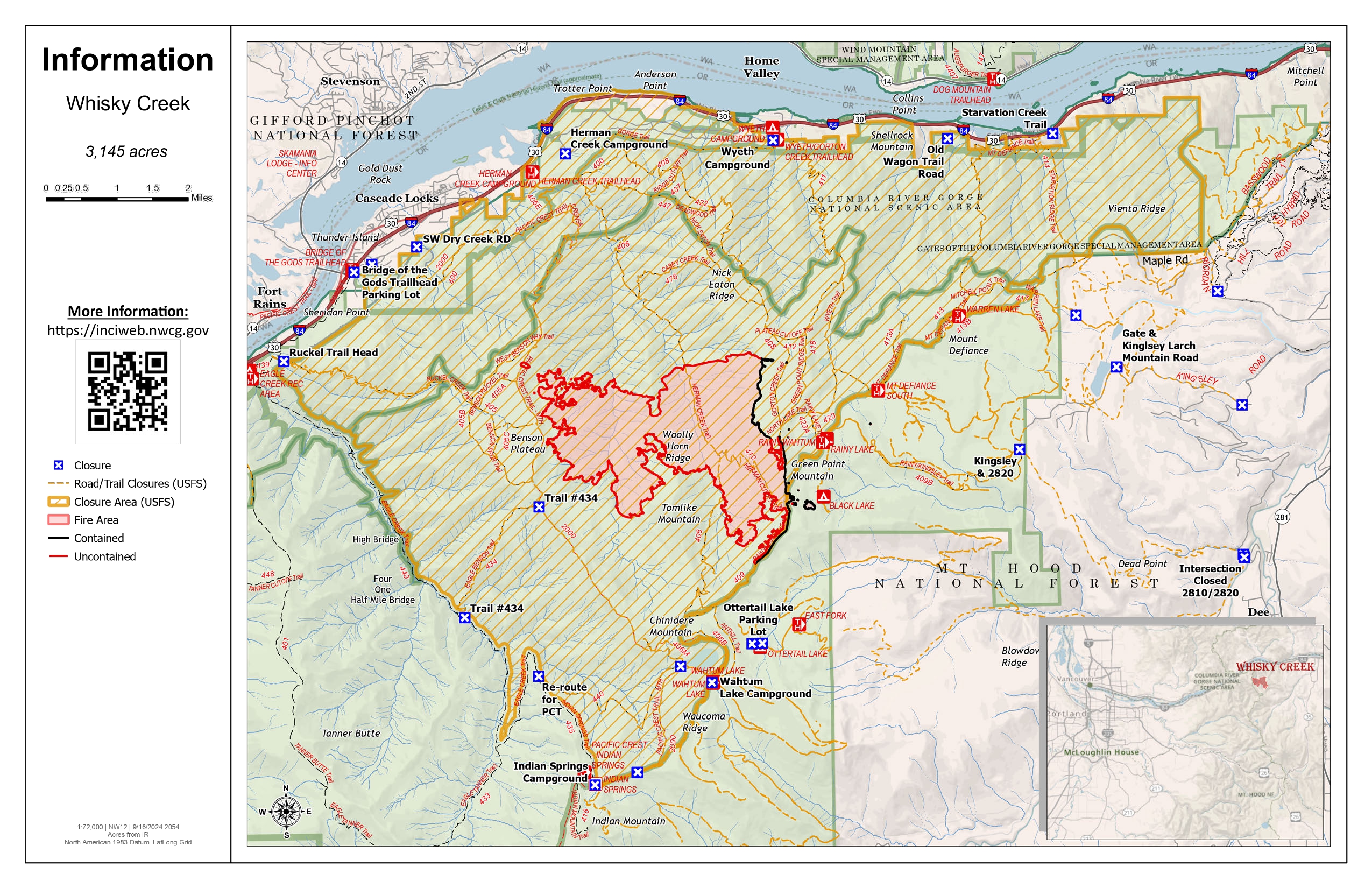
Actualizacin diaria del incendio Whisky Creek 09 21 2024
Related Incident: Whisky Creek Fire
Publication Type: News
Tamaño de Whisky Creek: 3,169 acres | Fecha de inicio: 20 de julio |Causa: De orígen humano |Contención 25%
Total de recursos: 72 | Equipos de obreros: 3 | Camiones de bomberos: 3 | Camiones de agua: 2 | Maquinarias pesadas:2
El incendio Whisky Creek se encuentra en un terreno escarpado y escabroso dentro del área de naturaleza Mark O. Hatfield en el Bosque Nacional Mt. Hood. Permanece dentro de las líneas de control a lo largo de los extremos sur y este. La huellas del incendio Eagle Creek continúan como barrera a lo largo de los extremos oeste y norte del incendio.
El crecimiento se ha visto a lo largo del extremo sur del incendio y no representa una amenaza para las líneas de control. Sigue ardiendo entre troncos pesados y continuará produciendo humo ligero. No se espera que empeore la intensidad del fuego aunque el clima en el área se ponga más soleado y cálido.
Ayer, las cuadrillas de mano removieron árboles que estaban a riesgo de quemarse cerca de la intersección del camino forestal 2820 y el sendero forestal 409b. Los asesores de recursos acompañaron a los bomberos mientras que fueron explorar un helipuerto en el área de naturaleza sobre Rainy Lake que se usó durante el trabajo de extinción. Cuando encontraron un sitio, vieron lo que se tenía que reparar para restaurar la zona.
Clima: Las altas presiones contribuirán a mantener el clima seco con temperaturas estacionales hasta el sábado. Habrán vientos ligeros en dirección este del mar, lo que muy probablemente causará más humo en la zona. Las recuperación de humedad seguirá de buena a excelente. Este patrón debe continuar todo el día.
Para saber el pronóstico de humo y seguridad, consulte: oregonsmoke.org.
Cierres: Los cierres de áreas permanecerán en el Bosque Nacional Mt. Hood, el Área Escénica Nacional Columbia River Gorge y el Condado de Hood River. Se establecen cierres para la seguridad del público y de los bomberos; La intrusión en un área de cierre puede interrumpir las actividades de extinción y reparación de incendios, poner en peligro vidas y propiedades, y puede resultar en multas. La información de cierre se encuentra en: https://linktr.ee/whisky_creek.2024.
Seguridad: El público juega un papel importante en la prevención del próximo incendio forestal; tenga cuidado con cualquier posible fuente de incendio. Para obtener consejos de prevención, consulte: https://keeporegongreen.org. La restricción temporal contra vuelos sigue vigente para el incendio Whisky Creek: https://tinyurl.com/2s49yrj4.