
Final McKinney Fire Update 8192022
Related Incident: McKinney Fire
Publication Type: News
Location: Siskiyou County, CA
Number of Personnel Assigned: 948
Start Date: Friday July 29, 2022, at 2:15 pm
The Townsend Fire, the Yellowjacket Fire, and the Thompkins Fire are all contained. The Hamburg fire remains in patrol status.
WEATHER:
EVACUATIONS:
CURRENT FOREST ORDERS:
Pacific Crest Trail Information: https://www.pcta.org/discover-the-trail/closures
McKinney Fire Evacuations Lifted 8182022
Related Incident: McKinney Fire
Publication Type: Announcement
All evacuations have been lifted on the McKinney Fire as of 8/18/2022.
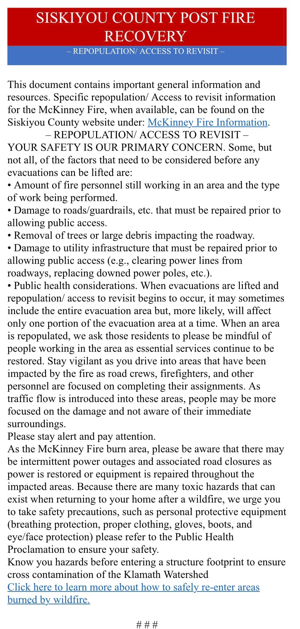
This document contains important general information and resources. Specific repopulation/ access to revisit information for the McKinney Fire, when available, can be found on the Siskiyou County website under: McKinney Fire Information.
– REPOPULATION/ ACCESS TO REVISIT –
YOUR SAFETY IS OUR PRIMARY CONCERN. Some, but not all, of the factors that need to be considered before any evacuations can be lifted are:
• Amount of fire personnel still working in an area and the type of work being performed.
• Damage to roads/guardrails, etc. that must be repaired prior to allowing public access.
• Removal of trees or large debris impacting the roadway.
• Damage to utility infrastructure that must be repaired prior to allowing public access (e.g., clearing power lines from roadways, replacing downed power poles, etc.).
• Public health considerations. When evacuations are lifted and repopulation/ access to revisit begins to occur, it may sometimes include the entire evacuation area but, more likely, will affect only one portion of the evacuation area at a time. When an area is repopulated, we ask those residents to please be mindful of people working in the area as essential services continue to be restored. Stay vigilant as you drive into areas that have been impacted by the fire as road crews, firefighters, and other personnel are focused on completing their assignments. As traffic flow is introduced into these areas, people may be more focused on the damage and not aware of their immediate surroundings.
Please stay alert and pay attention.
As the McKinney Fire burn area, please be aware that there may be intermittent power outages and associated road closures as power is restored or equipment is repaired throughout the impacted areas. Because there are many toxic hazards that can exist when returning to your home after a wildfire, we urge you to take safety precautions, such as personal protective equipment (breathing protection, proper clothing, gloves, boots, and eye/face protection) please refer to the Public Health Proclamation to ensure your safety.
Know you hazards before entering a structure footprint to ensure cross contamination of the Klamath Watershed
Click here to learn more about how to safely re-enter areas burned by wildfire.
# # #
McKinney Fire Update 8172022
Related Incident: McKinney Fire
Publication Type: News
Location: Siskiyou County, CA
Size: 60,392 acres
Percent Contained: 95%
Cause: Under Investigation
Start Date: Friday July 29, 2022 at 2:15pm
Vegetation: Timber (Litter and Understory), Tall Grass, and Brush
Number of Personnel Assigned: 1,197
The McKinney Fire remains at 95 percent containment. Firefighters continue to make excellent progress with containment along the entire fire perimeter. An Unmanned Aircraft System (UAS) flew the area of the fire using infrared to identify the latitude and longitudes of new hot spots. With the help of the UAS, crews are seeking out those areas and continue with full suppression tactics. The suppression repair process carries on in areas of ground surface disturbance. Examples of disturbed surfaces include hand line and dozer lines.
Crews mitigate the impact of erosion by placing water bars throughout the impacted area. Water bars are shallow channels or raised barriers laid diagonally across the surface of a road or trail to direct water off the line and reroute it into the vegetation to absorb. Firefighters monitor islands of unburned fuel that sit well within the interior. Smoke and heat still exist in those green islands. Air operations is supporting firefighters by cooling the heat that still exists.
WEATHER:
Red Flag Warning in effect Wednesday from 12:00 pm through 11:00 pm for dry lightning. Thunderstorm chances have risen to 30% and are possible through the operational period. Chances for wetting rain have risen to 15%. Strong outflow winds up to 50 mph are possible with any thunderstorm. Heat Advisory in effect for afternoon highs in the low to mid 100s. However, cloud cover from thunderstorms may limit heating to below advisory criteria.
LOCAL ASSISSTANCE CENTER:
A Local Assistance Center (LAC) will be opening at the College of the Siskiyous Rural Health Sciences Institute in Yreka to serve residents impacted by the McKinney Fire. The LAC is a one-stop-shop for recovery assistance. The address is 2001 Campus Drive Yreka, CA. The times of operation are Wednesday August 17, 9 am to 7 pm and Thursday August 18, 9 am to 7 pm.
EVACUATIONS:
Multiple evacuation orders and warnings remain in effect. For current updates on evacuations, visit https://www.facebook.com/SiskiyouCountySheriff and https://www.facebook.com/SiskiyouCountyOES Additional evacuation information and a map can be found on the Zonehaven site at: https://community.zonehaven.com/
Traffic on Highway 96 is limited with piloted traffic between Beaver Creek to Kohl Creek through the fire area.
CURRENT FOREST ORDERS:
Fire restrictions are in effect on the Klamath National Forest. For more information, visit https://www.fs.usda.gov/alerts/klamath/alerts-notices/
An emergency area is now in effect for the McKinney, Yeti, and Alex Fires. Please refer to the links below for specific details:
Closure Info: https://www.fs.usda.gov/Internet/FSE_DOCUMENTS/fseprd1053941.pdf Closure Map: https://www.fs.usda.gov/Internet/FSE_DOCUMENTS/fseprd1053892.pdf
Pacific Crest Trail Information: https://www.pcta.org/discover-the-trail/closures
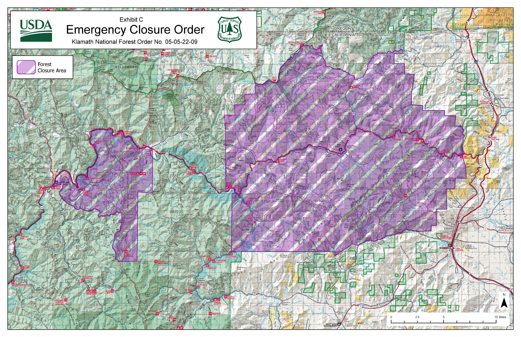
Klamath National Forest Closure Order 8172022
Related Incident: McKinney Fire
Publication Type: Closures
Pursuant to 16 U.S.C. § 551 and 36 C.F.R. § 26 l .50(a) and (b), and to provide for public safety, the following acts are prohibited within the Happy Camp, Oak Knoll, and Scott River Ranger Districts of the Klamath National Forest. This Order is effective from August 13, 2022, at 11 AM, through August 31, 2022.
l. Going into or being upon National Forest System lands within the McKinney Fire
Restricted Area ( described in Exhibit A) or the Yeti Fire Restricted Area ( described in Exhibit B), as shown on the attached map, Exhibit C. 36 C.F.R. § 261.52(e).
2. Being on any National Forest System Road within the McKinney Fire Restricted Area (listed in Exhibit A) or the Yeti Fire Restricted Area (listed in Exhibit B), as shown on the attached map, Exhibit C. 36 C.F.R. § 261.54(e).3. Being on any National Forest System Trail within the McKinney Fire Restricted Area(listed in Exhibit A) or the Yeti Fire Restricted Area (listed in Exhibit B), as shown on the attached map, Exhibit C. 36 C.F.R. § 261.SS(a).4. Entering or using any Developed Recreation Site within the McKinney Fire Restricted Area (listed in Exhibit A) or the Yeti Fire Restricted Area (listed in Exhibit B), as shown on the attached map, Exhibit C. 36 C.F.R. § 261.58(b).
Pursuant to 36 C.F.R. § 261.50(e), the following persons are exempt from this Order:
l. Persons with Forest Service Permit No. FS-7700-48 (Permit for Use of Roads, Trails, or Areas Restricted by Regulation or Order), specifically exempting them from this Order.
2. Any Federal, State, or local officer, or member of an organized rescue or fire-fighting force in the performance of an official duty.3. Owners or lessees of land in the area to the extent necessary to access their property.
These prohibitions are in addition to the general prohibitions in 36 C.F.R. Part 261, Subpart A. A violation of these prohibitions is punishable by a fine of not more than $5,000 for an individual or $10,000 for an organization, or imprisonment for not more than 6 months, or both. 16 U.S.C. § 551 and 18 U.S.C. §§ 3559, 3571, and 3581.
Emergency Area Closure Footprint Decreased for McKinney and Yeti Fires 817
Related Incident: McKinney Fire
Publication Type: Announcement
Emergency area closure footprint decreased for McKinney and Yeti Fires
Decreased fire activity and increased containment on the #McKinneyFire and #YetiFire have allowed Klamath National Forest officials to decrease the footprint of the emergency area closure that was implemented on August 3rd by nearly 95,000 acres. The new area closure is effective now.
The Forest’s goal in shrinking the closure area is to continue to provide for firefighter and public safety while affording users maximum access to public lands.
Fire activities continue around the areas of the closure, and equipment working on fire suppression and suppression repair are moving throughout the updated closure area. The closure affects lands on the Happy Camp/Oak Knoll and Salmon/Scott River Ranger Districts of the Klamath National Forest.
The closure restricts going into or being upon National Forest System lands, any National Forest System road or trail, and entering or using any Developed Recreation Site within the McKinney-Yeti Fire Restricted Areas.
Two separate areas are currently covered by this Order. Those areas include the McKinney and Yeti fires, and the surrounding areas that access the fire footprints.
Developed recreation areas that are included in this Order are as follows:
McKinney Fire
· Ash Creek River Access
· Johnson Bar River Access
· Cayuse River Access
· Skeahan Bar River Access
· Blue Heron River Access
· Beaver Creek Campground
· Sarah Totten Campground
· Tree of Heaven Campground
· Brown Bear River Access
· Humbug OHV Recreation Area
· Gottville River Access
Yeti Fire
· Cold Spring Trailhead
· Gordons Ferry River Access
· Grider Creek Campground
· Grider Creek Trailhead
Full details of this Order, including a map, can be viewed at: https://www.fs.usda.gov/alerts/klamath/alerts-notices/?aid=74764&fbclid=IwAR2-zK694WRQCyykhQkn3mPkbx0W7hVDVFxUU1YWZNvdMJBCVSsDOl4NQ94.
Only fire personnel are allowed to go into or be upon National Forest land within the emergency closure area. It is unsafe for Forest visitors to be near wildfires due to unpredictable changes in wind, rolling fire debris, poor visibility, and narrow roads busy with emergency vehicle traffic. Forest visitors are encouraged to seek alternative destinations. As conditions change, the Klamath National Forest will continue to update this closure area.
McKinney Fire Update 8152022
Related Incident: McKinney Fire
Publication Type: News
Location: Siskiyou County, CA
Size: 60,392 acres
Percent Contained: 95 %
Cause: Under Investigation
The McKinney Fire remains at 95 percent containment, but some changes will be taking place today. California Interagency Incident Management Team 2, under the direction of Incident Commander Nickie Johnny, working in a unified command with CalFire, has been managing the fire since Aug. 2. California Interagency Incident Management Team 12, under the direction of Incident Commander James Aragon, will be taking over the incident as of 7 am today. Firefighters continue suppression repair efforts and are patrolling throughout the fire perimeter. Crews are paying particular attention to areas of unburned vegetation within the interior of the fire containment lines, which have been producing smoke and heat. Aircraft was brought in to conduct aerial suppression operations on one of these pockets in the southwestern fire area. Three hand crews and a strike team of engines also conducted ground suppression and the “hot spot” posed no threat to the containment lines. Additionally, firefighters have been granted access to the McKinney Creek Road area, and repair work will begin within the next few days. As of Sunday evening, firefighters have constructed 62 miles of containment line by hand, and heavy equipment has constructed 142 miles of containment line. Only two miles of the fire is considered “uncontained” at this time. Forward progression of the fire has stopped, but steep terrain and the abundance of hazard trees are making it difficult for firefighters to perform mop-up in this area. Crews will keep working as safety allows.
WEATHER: Sunny and warm conditions are expected to continue throughout the week, with temperatures in the upper 90s in lower elevations and in the low-to-mid 80s on the ridgetops. West/northwest winds are predicted to be light, with gusts between 18-20 miles-per-hour. LOCAL
ASSISSTANCE CENTER: A Local Assistance Center (LAC) will be opening at the College of the Siskiyous Rural Health Sciences Institute in Yreka to serve residents impacted by the McKinney Fire. The LAC is a one-stop-shop for recovery assistance. The address is 2001 Campus Drive Yreka, CA. The times of operation are Wednesday August 17, 9 am to 7 pm and Thursday August 18, 9 am to 7 pm.
EVACUATIONS: Multiple evacuation orders and warnings remain in effect. For current updates on evacuations, visit https://www.facebook.com/SiskiyouCountySheriff and https://www.facebook.com/SiskiyouCountyOES Additional evacuation information and a map can be found on the Zonehaven site at: https://community.zonehaven.com/
A shelter has been established at Karuk Wellness Center at 1403 Kahtishraam, Yreka, CA, 96097. Traffic on Highway 96 is limited with piloted traffic between Beaver Creek to Kohl Creek through the fire area.
CURRENT FOREST ORDERS: Fire restrictions are in effect on the Klamath National Forest.
For more information, visit https://www.fs.usda.gov/alerts/klamath/alerts-notices/ An emergency area is now in effect for the McKinney, Yeti, and Alex Fires.
Please refer to the links below for specific details:
Closure Info: https://www.fs.usda.gov/Internet/FSE_DOCUMENTS/fseprd1047211.pdf
Closure Map: https://www.fs.usda.gov/Internet/FSE_DOCUMENTS/fseprd1047212.pdf
Pacific Crest Trail Information: https://www.pcta.org/discover-the-trail/closures
Diamond Watch Fact Sheet 8192022
Related Incident: Diamond Watch Fire
Publication Type: News
Diamond Watch
Fact Sheet
8/19/2022
Inciweb: https://inciweb.nwcg.gov/incident/8264/
Facebook: https://www.facebook.com/USFSIPNF
Idaho Panhandle National Forests, Priest Lake Ranger District
Phone: (208) 557-8813
Location: 5.5 miles west of Nordman, ID in Pend Oreille County, WA
Size: 701 acres Personnel: 34 Containment: 0%
Incident Commander: ICT4 Hirst
Current Status: The Diamond Watch Fire, detected on the evening of July 14th, was started by lightning and is visible from ID Highway 57 near Nordman ID in the Priest Lake area Drivers are cautioned not to stop on the highway in the fire area. The fire is located 5.5 miles due west of Nordman, ID, and is burning mostly on the south aspect of Diamond Peak in Pend Oreille County, WA. Recent growth was mapped with an infrared flight and the fire is currently at 701 acres, most of the heat continues to be on the south slope of the ridge.
Planned Actions: The fire has reached containment lines on parts of the southeast and southwest portion of the fire on Forest Service Road (FSR) 308 and parts of the northwest portion of the fire just southeast of Petit Lake on FSR 657. The forest roads surrounding the fire are being used as containment lines and have been reinforced with the clearing of vegetation from heavy machinery paralleling the roads. Fire crews are utilizing type 6 fire engines and standing ready to suppress the fire as it reaches the containment lines. FSR 308 is being used as the southern and western containment lines and FSR 657 has been reinforced on the east with the use of a D5 bulldozer connecting FSR 308 to Diamond Creek. Diamond Creek will act as a natural barrier keeping the fire contained on the northern edge in addition to FSRs 311 and 657. Fire crews are nearing completion of the western containment line as heavy machinery complete clearing vegetation and fuel from the side of FSR 308.
Objectives: The safety of firefighters and the public is the primary objective. Fire managers are using a confine strategy, with management action points in place to quickly respond to changes in the fire. Suppression activities are occurring where they have the greatest probability of success while limiting exposure to firefighting resources.
Closures & Evacuations: An area and road closure is in place, effective for Forest Service Roads 311, 308 and 1362H and the area in the vicinity of the Diamond Watch Fire. Petit Lake and its associated dispersed campsites are within the area closure. FSR 1362 remains open. This closure is for public safety due to heavy equipment operations and wildfire effects of the Diamond Watch Fire, and prohibits all methods of travel (foot, mechanized, motorized and stock) on the closed roads and area (see Closure Map). The best access to the Priest Lake area from the Colville National Forest will be through Newport, WA via US Highway 2 north and Priest River, ID via ID Highway 57 north. There are NO evacuations currently in place. However, when living in fire prone areas it is recommended that all area residents have an evacuation plan in place including having all important documents, pictures, prescriptions, and pets gathered up and easily transportable. Residents of Bonner County, ID or Pend Oreille, WA can visit https://www.nixle.com or text home zip code to 888777 to sign up for emergency alerts.
Diamond Watch Fire Fact Sheet 8152022
Related Incident: Diamond Watch Fire
Publication Type: News
Diamond Watch Fire
Fact Sheet
8/15/2022
Inciweb: https://inciweb.nwcg.gov/incident/8264/
Facebook: https://www.facebook.com/USFSIPNF
Idaho Panhandle National Forests, Priest Lake Ranger District
Phone: (208) 557-8813
Location: 5.5 miles west of Nordman, ID in Pend Oreille County, WA
Size: 391 acres Personnel: 34 Containment: 0%
Incident Commander: ICT4 Hirst
Current Status: The Diamond Watch Fire detected on the evening of July 14th, was started by lightning and is visible from ID Highway 57 near Nordman ID in the Priest Lake area, drivers are cautioned not to stop on the highway in the fire area. The fire is located 5.5 miles due west of Nordman, ID, and is burning on a ridge to the east of Diamond Peak in Pend Oreille County, WA. Recent growth was mapped with an infrared flight and the fire is currently at 391 acres, most of the heat is showing on the south slope of the ridge.
Planned Actions: Crews have been successful in utilizing heavy machinery to improve FSR 308 by removing excess fuel from roadsides which will support holding and containment of the fire. Fire is backing towards FSR 308, which is being utilized as a containment line. This fire activity, along with the use of heavy equipment, has prompted the closure of the area as firefighters continue suppression work on the fire. Handline construction is occurring at the head of Diamond Creek and firefighters are also utilizing natural barriers such as ridges and creeks. Crews work to keep fire from crossing FSR 657 and have placed a sprinkler system on the northern edges of the fire, which is working to keep the fire out of the adjacent timber units.
Objectives: The safety of firefighters and the public is the primary objective. Fire managers are using a confine strategy, with management action points in place to quickly respond to changes in the fire. Suppression activities are occurring where they have the greatest probability of success while limiting exposure to firefighting resources.
Closures & Evacuations: An area and road closure has been issued, effective for Forest Service Roads 311, 308 and 1362H and the area in the vicinity of the Diamond Watch Fire. Petit Lake and its associated dispersed campsites are within the area closure. FSR 1362 remains open. This closure is for public safety due to heavy equipment operations and wildfire effects of the Diamond Watch Fire, and prohibits all methods of travel (foot, mechanized, motorized and stock) on the closed roads and area (see Closure Map). The best access to the Priest Lake area from the Colville National Forest will be through Newport, WA via US Highway 2 north and Priest River, ID via ID Highway 57 north. There are NO evacuations currently in place. However, when living in fire prone areas it is recommended that all area residents have an evacuation plan in place including having all important documents, pictures, prescriptions, and pets gathered up and easily transportable. Residents of Bonner County, ID or Pend Oreille, WA can visit https://www.nixle.com or text home zip code to 888777 to sign up for emergency alerts.
Hog Trough Fire Daily Update August 22 2022
Related Incident: Hog Trough Fire
Publication Type: News
CURRENT STATUS
Fire behavior on the Hog Trough Fire was minimal yesterday due to cooler temperatures, scattered precipitation, and higher humidity levels. Crews will steer the fire to the south and east, through previously burned areas where there are fewer values at risk. There will be minimal to no perimeter growth to the north and northwest.
Today on the southwest flank of the Hog Trough Fire, crews will continue brushing the Weasel Creek Trail to clear flammable materials. A dozer will begin improving the 1135 Road, north of the Weasel Creek Trail, as a contingency line to stop fire progression to the north. To the southeast, crews built line around and held a slop-over fire that crossed of the Signal Rock Trail yesterday. Today, crews will conduct planned firing operations off of the Signal Rock Trail, routing the fire slowly back down the hill as a means to widen the fuel break in a safe and controlled manner, halt wildfire progression to the north, and prevent more slop-over fires from occurring. When completed, the fireline along the Signal Rock Trail will tie into the 5071 Road at a wet riparian area.
The Fuse Lake Fire has showed little to no perimeter growth yesterday and is now 75% contained. Today, crews will work along the fire edge, mopping up and extinguishing hot spots. Helicopters will fly supply missions and fill water tanks with buckets. With significant lightning recently, ground and air resources will be available to respond to new fire starts nearby.
WEATHER AND FIRE BEHAVIOR
Expect scattered showers and thunderstorms this afternoon. Gusty erratic outflow winds, lightning, and brief heavy rainfall will accompany thunderstorms. Lightning may result in new fire ignitions where fuels are receptive. Fire behavior on the Fuse Lake Fire is minimal with smoldering. Fire behavior on the Hog Trough Fire will be moderate with creeping, smoldering and some single tree torching.
CLOSURES AND SPECIAL MESSAGES
Skalkaho Highway (Highway 38) is open.
Road Closures:
- Skalkaho Road (Forest Service road 75) and Forest Service road 711 are both closed at the junction of Skalkaho Highway, including the ancillary roads leading from the 711 Road. Skalkaho Road is open past Mile Marker 5 (Skalkaho Creek-Jerry Lake Trailhead #503).
- Forest Service roads 5070 and 5071 are closed.
Trail Closures:
- Railroad Creek, National Forest System Trail #77 to Trail #313 at the gate.
- Weasel Creek, National Forest System Trail #156 from milepost 0.00 at its junction with NFSR #461.
- A section of the Bitterroot Rock Creek Divide Trail #313, National Forest System Trail #313 where it intersects Trail #77 Railroad Creek, Weasel Creek Trail #156.
- Skalkaho Creek – Jerry Lake Trail #503, National Forest System Trail #503.
Fire Restrictions: Stage 2 Fire Restrictions on all Bitterroot National Forest lands in Montana. See mtfireinfo.org for more specific restrictions information.
Hog Trough Fire Daily Update August 21 2022
Related Incident: Hog Trough Fire
Publication Type: News
CURRENT STATUS
The south and southeast areas of the fire saw limited growth on the Hog Trough Fire yesterday. Today, on the southwest flank, crews will complete improving the Weasel Creek Trail and tie it in with the 75 Road. A dozer will begin improving the 1135 Road, north of the Weasel Creek Trail, as a contingency line to stop fire from spreading to the north. On the east flank, crews used previously installed hose lays to mop up pockets of heat in the Signal Rock area. Crews will continue to the improve the 8131 Trail in preparation to tie into the 7051 Road and halt the possibility of fire movement to the north there as well. The Helena and Bitterroot Hotshot crews will assess the Weasel Creek Trail and the 8131 Trail areas for potential firing operations in order to widen the fire break. With significant lightning recently, ground and air resources will be available to respond to new fire starts nearby.
Fire behavior on the Fuse Lake Fire is minimal with little to no perimeter growth. Today, crews will utilize hand tools, hose lays and water tanks to in order to expose and extinguish remaining hot spots near the fire perimeter. Crews will also search for and suppress any spot fires. Helicopters will fly supply missions and fill water tanks with buckets.
WEATHER AND FIRE BEHAVIOR
Showers and thunderstorms will develop near the fire Sunday afternoon, however there is a very low chance of wetting rain. Humidity will improve and thermal belts will weaken. Evening thunderstorms may produce lightning outside of the wet core and new fire ignitions are likely to occur. Fire behavior on the Fuse Lake Fire is minimal with smoldering. The Hog Trough Fire will see moderate fire behavior with single and group tree torching and short-range spotting along the south flank and minimal fire behavior with creeping and smoldering in other areas.
CLOSURES AND SPECIAL MESSAGES
Skalkaho Highway (Highway 38) is open.
Road Closures:
- Skalkaho Road (Forest Service road 75) and Forest Service road 711 are both closed at the junction of Skalkaho Highway, including the ancillary roads leading from the 711 Road. Skalkaho Road is open past Mile Marker 5 (Skalkaho Creek-Jerry Lake Trailhead #503).
- Forest Service roads 5070 and 5071 are closed.
Trail Closures:
- Railroad Creek, National Forest System Trail #77 to Trail #313 at the gate.
- Weasel Creek, National Forest System Trail #156 from milepost 0.00 at its junction with NFSR #461.
- A section of the Bitterroot Rock Creek Divide Trail #313, National Forest System Trail #313 where it intersects Trail #77 Railroad Creek, Weasel Creek Trail #156.
- Skalkaho Creek – Jerry Lake Trail #503, National Forest System Trail #503.
Fire Restrictions: Stage 2 Fire Restrictions on all Bitterroot National Forest lands in Montana. See mtfireinfo.org for more specific restrictions information.