
Magruder Corridor is open
Related Incident: Indian Ridge
Publication Type: Announcement
Magruder Corridor is open! You can travel from Darby, MT to Elk City, ID. The road closure from the Twist Fire has been rescinded. The road is now open again between Observation Point and Sable Saddle. Please note: the area closure for the Indian Ridge fire is still in place.
West Fork Ranger District Fire Update Hunting Season
Related Incident: Indian Ridge
Publication Type: Announcement
Hamilton, MT, September 14 — General firearms hunting season in Idaho begins tomorrow, September 15th, and the Bitterroot National Forest is reminding public land users to be aware of ongoing fire activity, especially in Wilderness areas on the West Fork Ranger District. “We recognize that the Selway Bitterroot and Frank Church River of No Return Wilderness Areas provide once in a lifetime hunting opportunity and a place to get away into some peace and quiet. So, we are doing our best to keep that opportunity available while weighing the risks to the public and firefighters in proximity of wildfires” said West Fork District Ranger Dan Pliley.
Currently, there are 12 wildfires burning in the Wilderness areas on the West Fork District. These fires are being managed to provide protection of infrastructure in the developed recreation sites along the Magruder Corridor and Paradise Road. The largest of these fires is the Indian Ridge Fire at roughly 13,000 acres. Last night, the fire reached the road near Magruder Crossing. Current fire activity, rolling debris and falling snags has prompted the temporary closure of the Magruder Corridor north of the Magruder Ranger Station. Fire personnel are working to reopen the road for public travel as soon as conditions allow for safe passage.
The Twist Creek fire, roughly 2,300 acres, is burning near Horse Heaven Cabin and Salmon Base Camp. The fire impacted approximately 2 miles of the road prompting a closure of the Magruder Corridor between Observation Point Campground and Sabe Saddle. Falling teams are working to mitigate fire weakened trees along the road. As conditions allow for safe passage and fire behavior moderates, fire managers will reassess the need for a road closure in this area.
Aside from these two large fires, eight other fires are showing activity and range in size from 100 to 300 acres. Please be aware that these fires are on the landscape and conditions may change rapidly until the area receives moisture.
If you choose to venture into these areas, you need to be flexible. Fires are unpredictable. You may have to change and alter your plans depending on road and trail closures. Additional sections of the roads and areas may be impacted by the fire, causing additional closures and/or delays at any point in time. Firefighters are constantly reviewing the risk to public and fire management to inform any needed closures.
You will notice the recreation sites look a little different. Picnic tables, signs, and outhouses will be bright and shiny as they are wrapped with fire resistant structure wrap. This helps protect them from heat and embers if the fire approaches. Even though they are wrapped, outhouses are likely still open if accessible.
Please know where the fires are and their proximity to you. Stay aware of the conditions on the ground. Be flexible and patient with changes. For more information, visit the Indian Ridge and Twist Creek Fire Inciweb pages, Bitterroot National Forest website and Facebook page. See links below.
Finally, please give the West Fork Ranger District a call at (406) 821-3269 before you come out to check current conditions or new closures.
Inciweb: https://inciweb.nwcg.gov/incident/8319/ (Indian Ridge)
https://inciweb.nwcg.gov/incident/8377/ (Twist Creek)
Bitterroot NF Website: www.fs.usda.gov/bitterroot
Facebook: www.facebook.com/DiscoverBitterrootNFSeptember 98 Fire Update
Related Incident: Indian Ridge
Publication Type: News
Resources assigned include handcrew, Wildfire Use Module, and Trapper Creek Type 2IA crew. Structure Preparation has been completed at Magruder Crossing Campground, Beaver Point Campground, Raven Creek Campground, Spot Mountain Pack Bridge and Indian Creek . Current actions include monitoring fire movement in Indian Creek and Steep Gulch towards Magruder Crossing and the Paradise road. The road to Paradise is still open. On the Western side of the fire the most active areas are in upper Nick Creek/Steep Gulch. Most of the recent growth on the east side has been in Jack, Schofield and Indian Creeks. The fire is now about 3.5 miles west of Indian Hill along the MT/ID border.
BREAKING Magruder Road Corridor Currently Closed by Twist Creek Fire
Related Incident: Indian Ridge
Publication Type: Announcement
Pushed by strong SW/W winds the Twist Creek Fire became very active this afternoon making a run up Bend Creek and crossing the Magruder Road Corridor east of Horse Heaven Cabin.
Due to current and expected fire behavior, fire personnel have implemented a road closure of the Magruder Corridor between Sabe Saddle and Observation Point to ensure public safety.
Magruder Road connecting Darby, MT. and Elk City, ID., is a 101-mile primitive wilderness road.
Tomorrow will be another critical fire weather day requiring the road closure remain in place. If fire behavior moderates later this week, fire managers will look for opportunities to allow traffic through in the mornings.
Visit this site for the latest updates or the Discover Bitterroot National Forest Facebook page at https://www.facebook.com/DiscoverBitterrootNF.
Thank you for your understanding and cooperation!
View the Closure and Map here.
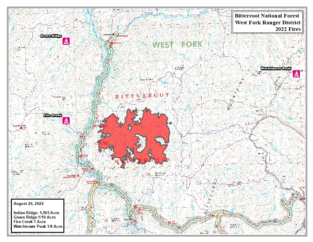
Indian Ridge Fire Update August 26 2022
Related Incident: Indian Ridge
Publication Type: News
Fire managers are utilizing a point protection strategy to prevent any critical wilderness infrastructure from being negatively impacted by the fire. Firefighters continue to take protection actions around paradise and Magruder road. Crews wrapped signs and tables with flame resistant foil and installed sprinklers on the road bridge. Firefighters finished structure preparation at Magruder Crossing Campground, Beaver Point Campground, Raven Creek Campground, Spot Mountain Pack Bridge and Indian Creek campground.
The fire received up to .60 inches of rain and hail Wednesday night (8/24), which may dampen fire behavior over the next couple days. Thunderstorms are predicted again Saturday and Saturday night. Sunday is the start of a drying trend with temps in the 80's.
As the fire moves closer to Paradise Road, there may be temporary road closures, including a barricade and road guard at Magruder Crossing. The area/trail closure over the fire area remains in place. Smoke may be visible south of Hamilton, primarily around Darby.
Six Rivers National Forest Forest Order NO 221007
Related Incident: Six Rivers Lightning Complex
Publication Type: Closures
SIX RIVERS NATIONAL FOREST - ORDER NO. 22-10-07 SRF Lightning Complex Pursuant to 16 U.S.C. § 551 and 36 C.F.R. § 261.50(a) and (b), and to provide for public safety, the following acts are prohibited within the Lower Trinity Ranger District of the Six Rivers National Forest. This Order is effective from September 8, 2022, through September 30, 2022.
- Going into or being upon National Forest System lands within the SRF Lightning Complex Closure Area, as described in Exhibit A and shown on Exhibit C. 36C.F.R. § 261.52(e).
- Being on any National Forest System road within the SRF Lightning Complex Closure Area, as listed in Exhibit B and shown on Exhibit C 36 C.F.R. § 261.54(e).
- Being on any National Forest System trail within the SRF Lightning Complex Closure Area, as listed in Exhibit B and shown on Exhibit C. 36 C.F.R. § 261.55(a).
- Entering or using any of the following Developed Recreation Sites: Boise Creek Campground, East Fork Campground, Gray Falls Day Use Area, or Big Rock River Access. 36 C.F.R. § 261.58(b).
Pursuant to 36 C.F.R. § 261.50(e), the following persons are exempt from this Order:
- Persons with Forest Service Permit No. FS-7700-48 (Permit for Use of Roads, Trails, or Areas Restricted by Regulation or Order),specifically exempting them from this Order.
- Any Federal, State, or local officer, or member of an organized rescue or fire- fighting force in the performance of an official duty.
- Owners or lessees of land in the area to the extent necessary to access their land.
- Residents, to the extent necessary to access their residences.
These prohibitions are in addition to the general prohibitions contained in 36 C.F.R. Part 261, Subpart A. A violation of these prohibitions is punishable by a fine of not more than $5,000 for an individual or $10,000 for an organization, or imprisonment for not more than six months, or both. 16 U.S.C. 8 U.S.C. §§ 3559, 3571,and 3581.
SIX RIVERS NATIONAL FOREST- ORDER NO. 22-10-07 SRF Lightning Complex Executed at Eureka, California this 8th day of September 2022. Signed by KATHY M. ALLEN, Acting Forest Supervisor
This Order supersedes Forest Order No. 22-10-06, executed August 9, 2022.
Exhibit A:
The SRF Lightning Complex Closure Area comprises a majority of the Lower Trinity Ranger District of Six Rivers National Forest and follows the district’s boundary for most of its perimeter, as shown on Exhibit C (map). The closure area begins where Forest System Roads 9N02 and 9N04 meet on the Hoopa Valley Indian Reservation’s eastern boundary (Township 9N, Range 5E, Section 15), near the district’s northernmost tip. The closure area continues south along the eastern reservation boundary to the reservation’s southeast corner, then continues west along the reservation’s southern boundary to the western edge of the district. The closure area then continues south along the district’s western boundary, inclusive of 20 outlying SRF parcels west of the contiguous Forest boundary (see Exhibit C). The closure area departs from the western district boundary at the boundary of sections 1 and 12 of Township 4 North, Range 4East, approximately 0.6 miles south of Grouse Mountain, heading east along the section boundary until reaching the eastern shoreline of the South Fork Trinity River. From this juncture, the closure area proceeds north along the eastern shoreline of the South Fork Trinity River until it intersects the Township 5 North / Township 6 North boundary, where it turns east. The closure area follows the township boundary east until it reaches the eastern boundary of the district, then turns north and follows the district boundary north until it returns to the start point at the Hoopa Reservation boundary.
Exhibit B: Forest System Roads within the Closure Area Roads (see page 4 and page 5)
Exhibit C: Forest Closure Area Map
SR Lightning Complex PostFire BAER Assessment
Related Incident: Six Rivers Lightning Complex
Publication Type: News
Six Rivers National ForestBurned Area Emergency Response (BAER)Post-Fire BAER AssessmentSeptember 12, 2022 BAER Information: (707) 853-4243
SR LIGHTNING COMPLEX POST-FIRE SOIL BURN SEVERITY MAPS RELEASEDAmmon Post-Fire Soil Burn Severity Map Campbell Post-Fire Soil Burn Severity Map
Forest Service BAER team specialists recently completed their field data gathering on federal lands burned by the Ammon and Campbell fires. The post-fire maps and data display soil burn severity (SBS) categories of unburned/very low, low, moderate, and high.
For the Ammon Fire, the BAER team analyzed approximately 11,457 acres and its burned watersheds for the different levels of SBS. Approximately 90% of the total acres are either unburned/very low or low SBS, while 8% are moderate SBS and 2% are high SBS.The BAER team’s Ammon post-fire assessment shows the land ownership acreage to be:• 10,516 acres of Six Rivers National Forest (NF) land, and• 941 acres of private lands.For the Campbell Fire, the BAER team analyzed approximately 30,230 acres and its burned watersheds for the different levels of SBS. Approximately 82% of the total acres are either unburned/very low or low SBS, while 16% are moderate SBS and 2% are high SBS.
The BAER team’s Campbell post-fire assessment shows the land ownership acreage for land ownership
to be:• 25,751acres of Six Rivers National Forest (NF) land, and• 4,479 acres of private lands.
The BAER assessment team used preliminary remote sensing data based on satellite imagery of the fire perimeter with field-validated data collected over several days to produce the final Ammon and Campbell Post-Fire SBS maps.
The BAER assessment team coordinates with other local and federal agencies such as county and state officials, the National Marine Fisheries Service (NOAA Fisheries), California Office of Emergency Services (CALOES), Natural Resources Conservation Service (NRCS), National Weather Service (NWS), US Geological Survey (USGS), and Tribes to share information about burned watershed conditions and their predicted response during certain rain events.
The SBS map products are an estimate of fire effects on soils and not a measure of direct effects to vegetation. SBS characterizes the soil surface and below-ground impact, whereas effects on vegetation are estimates of mortality based primarily on changes in vegetation canopy. The Rapid Assessment of Vegetation Condition after Wildfire (RAVG) program produces data describing post-fire vegetation conditions on federal lands. Changes in overhead and understory vegetation canopy are often used as initial indicators of overall vegetation burn severity, but do not necessarily coincide with SBS.
Changes in soil cover, water repellency, and soil physical/biological conditions guide the interpretations to determine the severity burn level of the soil. Water repellency can occur naturally in soil and may change as a result of fire. Fire can crease the strength and thickness (or depth) of water-repel ecting post-fire water runoff and possibly extending time for recovery of the burned area.
Soil burn severity indicators can be found within the Rocky Mountain Research Station’s General Technical Report 243 – Field Guide for Mapping Post-Fire Soil Burn Severity https://www.fs.usda.gov/rm/pubs/rmrs_gtr243.pdf and are described below.
Low SBS generally occurs where surface organic layers are not completely consumed and are still recognizable. Structural aggregate stability is not changed from its unburned condition, and roots are generally unchanged because the heat pulse below the soil surface was not great enough to consume or char any underlying organics. The ground surface, including any exposed mineral soil, may appear brown or black (lightly charred), and the canopy and understory vegetation will likely appear “green.” Lower risk for accelerated runoff, erosion, flooding, and debris flows is expected within and below these areas compared to moderate and high SBS.
In areas with moderate SBS, up to 80% of the pre-fire ground cover (litter and ground fuels) is consumed. Fine roots may be scorched but are rarely completely consumed over much of the area.
The color of the ash on the surface is generally blackened with possible gray patches. There may be potential for recruitment of effective ground cover from scorched needles or leaves remaining in the canopy that will soon fall to the ground. The prevailing color of the site is often “brown” due to canopy needle and other vegetation scorch. Soil structure is generally unchanged. Where greater amounts of reduced soil cover and increased water repellency occur, increased overland flow of water from precipitation is expected, most notably in locations where the overstory canopy no longer exists.
High SBS occurs where all or nearly all the pre-fire ground cover and surface organic matter (litter, duff, and fine roots) are consumed, and charring may be visible on larger roots. The prevailing color of the site is often “black” due to extensive charring. Bare soil or ash is exposed and susceptible to erosion, and aggregate structure may be less stable. White or gray ash (up to several centimeters in depth) indicates that considerable ground cover or fuels were consumed. Sometimes very large tree roots are entirely burned extending from a charred stump hole. Soil is often gray, orange, or reddish at the ground surface where large fuels were concentrated and consumed.
Generally, there is 100% tree mortality in forested areas with high SBS, and tree recovery will take many years without planting. In high SBS, the exposed bare soil is very prone to post-fire impacts. Rain events on damaged soil can cause excessive soil erosion, resulting in higher volumes of sediment delivery to adjacent creeks and rivers. There is increased likelihood for flooding and debris flows. These threats can individually or cumulatively increase the risk to human life and safety, property, infrastructure, and important critical natural and cultural resources.
The BAER team use the Ammon and Campbell SBS data to analyze and model post-fire hydrologic response for each of the watersheds to determine if there are threats or risks to BAER critical values: human life and safety, property, critical natural resources, and critical cultural resources. The team shares its analysis with cooperating agencies such as CalOES, NRCS, and Trinity and Humboldt counties who have the authority to work with private property owners downstream from the burned area that potentially may have post-fire threats from increased water and debris flows. The BAER team’s analysis and findings will be documented in an assessment report that will be posted to the SR Lightning Complex Post-Fire BAER InciWeb page after the report has been reviewed and approved by Forest Service leadership.
Both SBS maps can be downloaded at the “SR Lightning Complex Post-Fire BAER” InciWeb site (https://inciweb.nwcg.gov/incident/8384/) as a JPEG or PDF format image under the “Maps” tab.
For additional information about understanding SBS, see: Post-Fire Effects Understanding Soil Burn Severity - InciWeb the Incident Information System (nwcg.gov).
BAER SAFETY MESSAGE: Everyone near and downstream from the burned areas should remain alert and stay updated on weather conditions that may result in heavy rains and increased water runoff. Flash flooding may occur quickly during heavy rain events – be prepared to act. Current weather and emergency notifications can be found at the National Weather Service websites: www.weather.gov/sto/ and www.weather.gov/eka/.SR Lightning Comp essment information is available at: s://inciweb.nwcg.gov/incident/8384/
Six Rivers Lightning Complex UPDATE 9112022
Related Incident: Six Rivers Lightning Complex
Publication Type: News
Six Rivers Lightning Complex
September 10, 2022 UPDATE
Fire Information Line: (707) 356-9442
Email: 2022.LightningComplex@firenet.gov
Inciweb: https://inciweb.nwcg.gov/incident/8312/
Facebook: www.facebook.com/SixRiversNF
Remember the hours after September 11, when we came together as one!
The Six Rivers Lightning Complex is currently 41,540 acres with 91% containment and 783 personnel assigned to the incident. Ammon – 11,465 acres; Campbell – 30,075 acres.
CURRENT SITUATION
Cooler temperatures today and into next week, will be favorable for the current management strategies on the Lightning Complex. Fire crews will continue to monitor fire lines as heat pockets remain in the interior of the fire area. Resource Advisors (READs) are working in cooperation with US Forest Service and Hoopa Valley Tribal authorities to identify and preserve culturally, historically, and ecologically important sites within the fire areas.
Steep slopes combined with heavy dead fuel from last winter’s snow event, creates potential for smoldering material to come loose and roll across control lines. However, the likelihood of spot fires outside of the line is decreasing with the improving weather conditions. Firefighters will continue to patrol the control lines to ensure there are no unexpected changes.
The major focus at this stage of incident management remains on suppression repair. Suppression repair entails placing drainage dips along equipment lines, chipping brush and tree limbs that were cut along roadways, removing hazard trees, and repairing damaged roads. This work is extremely important to minimize erosion that can occur from storm events following a wildfire. Increased attention will also be focused on backhauling pumps and hose from the fireline back to this Incident Command Post to be refurbished and sent back to the supply cache where it can be deployed to the next fire.
Smoke production will continue to decrease improving overall air quality. You can monitor the air conditions in your area at the AirNow Fire and Smoke Map - https://fire.airnow.gov.
ROAD CLOSURES
Due to a large presence of fire personnel and machinery on roadways, residents are asked to limit travel on Titlow Hill Road/Route 1 in zones HUM-E052 and HUM-E062 to essential traffic only. Residents may still use roads to travel out of evacuation order zones:
The following roads into evacuation zones have been closed.
- Forest Route 7n15 at Six Rivers Forest Boundary
The following roads are restricted to local traffic only:
- Horse Linto Creek Road at Saddle Lane (Open to residents only)
-
- 6N06 Sandy Bar (Route 6)
- Titlow Hill Road (Route 1) at Horse Mountain Botanical Area
State Route 299 remains open to through traffic. Residents are encouraged to visit http://quickmap.dot.ca.gov/ to check for state highway closures.
FOREST CLOSURES
Forest order NO. 22-10-06 Six Rivers Lightning Complex is currently in place, which includes river access at Kimtu Park. To view this closure and map, please visit: www.fs.usda.gov/alerts/srnf/alerts-notices
EVACUATION UPDATES
For the latest evacuation information go to Humboldt County Office of Emergency Services https://humboldtgov.org/2383/Current-Emergencies https://community.zonehaven.com/.
To sign up for alerts: www.humboldtgov.org/alerts.
Six Rivers Lightning Complex UPDATE 9102022
Related Incident: Six Rivers Lightning Complex
Publication Type: News
Six Rivers Lightning Complex
September 10, 2022 UPDATE
Fire Information Line: (707) 356-9442
Email: 2022.LightningComplex@firenet.gov
Inciweb: https://inciweb.nwcg.gov/incident/8312/
Facebook: www.facebook.com/SixRiversNF
The Six Rivers Lightning Complex is currently 41,540 acres with 89% containment and 850 personnel assigned to the incident. Ammon – 11,465 acres; Campbell – 30,075 acres.
CURRENT SITUATION
Yesterday, the extreme heat peaked across the fire area yesterday, with a high of 1070 at 5:00 pm. Fire crews observed minimal fire activity that occurred on both the Ammon and Campbell fires. The only area that is still has significant fire activity is the approximately 60-acre pocket of unburned vegetation within the Campbell Fire near Horse Ridge. This burning remains well within the control lines and poses very little threat to containment. Shifting winds, later today, will test the northern perimeter where fire activity is still present, but crews remain confident that containment will hold and continue to increase.
An anticipated weather pattern change will begin today with a cooling trend which will provide improved fire weather conditions. Firefighters will advantage of the more favorable conditions as they continue to extinguish the remaining hot areas that can be safely accessed. Crews will continue to clear hazard trees from the roadways and implement the suppression repair plan.
Air quality should continually increase as fire activity declines. You can monitor the air conditions in your area at the AirNow Fire and Smoke Map - https://fire.airnow.gov.
ROAD CLOSURES
Due to a large presence of fire personnel and machinery working to build containment lines for the Ammon Fire, residents are asked to limit travel on Titlow Hill Road/Route 1 in zones HUM-E052 and HUM-E062 to essential traffic only. Residents may still use roads to travel out of evacuation order zones:
The following roads into evacuation zones have been closed.
- Forest Route 7n15 at Six Rivers Forest Boundary
The following roads are restricted to local traffic only:
- Horse Linto Creek Road at Saddle Lane (Open to residents only)
- 6N06 Sandy Bar (Route 6)
- Titlow Hill Road (Route 1) at Horse Mountain Botanical Area
State Route 299 remains open to through traffic. Residents are encouraged to visit http://quickmap.dot.ca.gov/ to check for state highway closures.
FOREST CLOSURES
Forest order NO. 22-10-06 Six Rivers Lightning Complex is currently in place, which includes river access at Kimtu Park. To view this closure and map, please visit: www.fs.usda.gov/alerts/srnf/alerts-notices
EVACUATION UPDATES
For the latest evacuation information go to Humboldt County Office of Emergency Services https://humboldtgov.org/2383/Current-Emergencies https://community.zonehaven.com/.
To sign up for alerts: www.humboldtgov.org/alerts.
CLEAN AIR FACILITIES:
Clean Air Centers are open at locations in eastern Humboldt and western Trinity counties for residents seeking relief from the smoky conditions. Please see the list below for times and locations: www.facebook.com/TrinityCoOES
###
USDA is an equal opportunity provider, employer and lender.
Six Rivers Lightning Complex UPDATE 9092022
Related Incident: Six Rivers Lightning Complex
Publication Type: News
Six Rivers Lightning Complex
September 9, 2022 UPDATE
Fire Information Line: (707) 356-9442
Email: 2022.LightningComplex@firenet.gov
Inciweb: https://inciweb.nwcg.gov/incident/8312/
Facebook: www.facebook.com/SixRiversNF
The Six Rivers Lightning Complex is currently 41,540 acres with 81% containment and 949 personnel assigned to the incident. Ammon – 11,465 acres; Campbell – 30,075 acres, with 38 acres of interior growth.
CURRENT SITUATION
Today, fire crews will continue to patrol the perimeter looking for any remaining hotspots. Firefighters will continue to fall hazard trees along roadways within the burned area and continue with suppression repair. Intense heat is expected again today but temperatures should begin to decrease over the next few days. Smoke production will decrease as fire activity declines, improving overall air quality. You can monitor the air conditions in your area at the AirNow Fire and Smoke Map - https://fire.airnow.gov.
ROAD CLOSURES
Due to a large presence of fire personnel and machinery working to build containment lines for the Ammon Fire, residents are asked to limit travel on Titlow Hill Road/Route 1 in zones HUM-E052 and HUM-E062 to essential traffic only. Residents may still use roads to travel out of evacuation order zones:
The following roads into evacuation zones have been closed.
- Forest Route 7n15 at Six Rivers Forest Boundary
The following roads are restricted to local traffic only:
- Horse Linto Creek Road at Saddle Lane (Open to residents only)
- 6N06 Sandy Bar (Route 6)
- Titlow Hill Road (Route 1) at Horse Mountain Botanical Area
State Route 299 remains open to through traffic. Residents are encouraged to visit http://quickmap.dot.ca.gov/ to check for state highway closures.
FOREST CLOSURES
Forest order NO. 22-10-06 Six Rivers Lightning Complex is currently in place, which includes river access at Kimtu Park. To view this closure and map, please visit: www.fs.usda.gov/alerts/srnf/alerts-notices
EVACUATION UPDATES
For the latest evacuation information go to Humboldt County Office of Emergency Services https://humboldtgov.org/2383/Current-Emergencies https://community.zonehaven.com/.
To sign up for alerts: www.humboldtgov.org/alerts.
CLEAN AIR FACILITIES:
Clean Air Centers are open at locations in eastern Humboldt and western Trinity counties for residents seeking relief from the smoky conditions. Please see the list below for times and locations: www.facebook.com/TrinityCoOES
###
USDA is an equal opportunity provider, employer and lender.