
Highlighted Media
At 8 p.m. PST on Sept. 11, a local type 4 team took command of the Sandstone Fire. See the Mt. Hood National Forest website and Facebook page for future information on this fire.
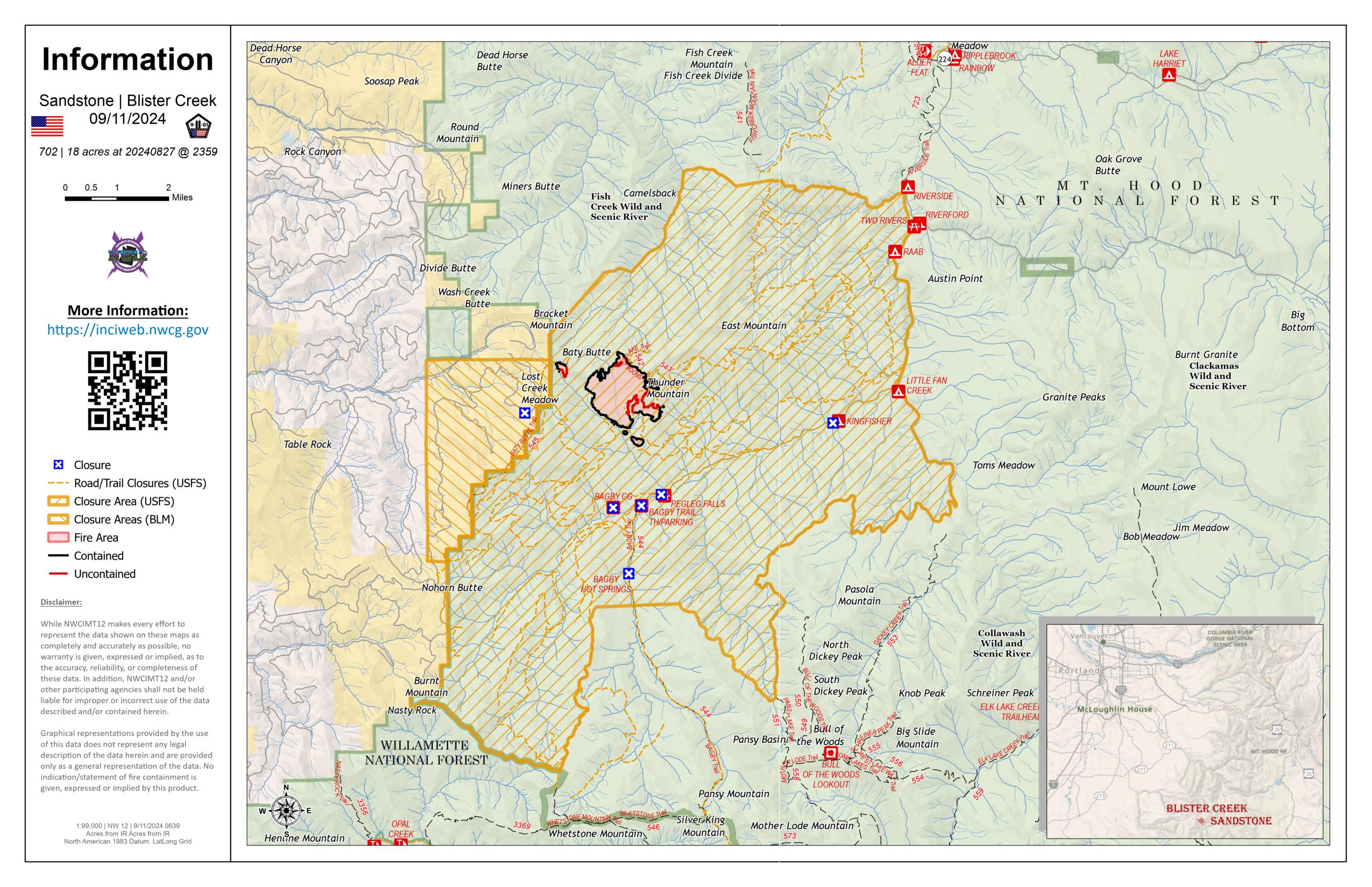
The Sandstone Fire ignited from a lightning strike on Monday, August 5, after a lightning storm event. The fire is located on the south side of Thunder Mountain several miles north of Forest Road 70 on the Clackamas River Ranger District and 9 miles southwest of Ripplebrook OR, on the Mt. Hood National Forest.
At 6 a.m. on August 17, Northwest Complex Incident Management Team 10 took command of the fire, which also includes the Blister Creek Fire. The fire is currently burning in the 2006 Blister Fire burn scar, where there is dead and down fuel and remote, steep, rugged terrain.
While much of the fire area is remote, if the fire were to spread significantly, it could affect nearby population centers in Clackamas County. Fire managers are using a full-suppression strategy to protect private property, public infrastructure, and natural and recreation resources while minimizing risks to responders and the public. Firefighters continue to establish firelines and hose lays, working in conjunction with water-dropping aircraft.
The Mt. Hood National Forest has a closure order in place for the area around the Sandstone Fire. Closed trails include Skookum Lake Trail (#542) and Thunder Mountain Trail (#543). Closed Recreation Sites within the Closure Area include Kingfisher Campground and Pegleg Falls. Please see the 'Closures' tab for more information.
At 8 p.m. PST on Sept. 11, a local type 4 team took command of the Sandstone Fire. See the Mt. Hood National Forest website and Facebook page for future information on this fire.
The Sandstone Fire ignited from a lightning strike on Monday, August 5, after a lightning storm event. The fire is located on the south side of Thunder Mountain several miles north of Forest Road 70 on the Clackamas River Ranger District and 9 miles southwest of Ripplebrook OR, on the Mt. Hood National Forest.
At 6 a.m. on August 17, Northwest Complex Incident Management Team 10 took command of the fire, which also includes the Blister Creek Fire. The fire is currently burning in the 2006 Blister Fire burn scar, where there is dead and down fuel and remote, steep, rugged terrain.
While much of the fire area is remote, if the fire were to spread significantly, it could affect nearby population centers in Clackamas County. Fire managers are using a full-suppression strategy to protect private property, public infrastructure, and natural and recreation resources while minimizing risks to responders and the public. Firefighters continue to establish firelines and hose lays, working in conjunction with water-dropping aircraft.
The Mt. Hood National Forest has a closure order in place for the area around the Sandstone Fire. Closed trails include Skookum Lake Trail (#542) and Thunder Mountain Trail (#543). Closed Recreation Sites within the Closure Area include Kingfisher Campground and Pegleg Falls. Please see the 'Closures' tab for more information.
| Current as of | Mon, 10/07/2024 - 13:29 |
|---|---|
| Incident Time Zone | America/Los_Angeles |
| Incident Type | Wildfire |
| Cause | Lightning |
| Date of Origin | |
| Location | 9 miles SW of Ripplebrook, OR, on the Mt. Hood National Forest |
| Incident Description | Lightning caused wildfire. This is a full suppression fire. |
| Coordinates |
44° 59' 19'' Latitude
-122° 10' 45
'' Longitude
|
| Total Personnel: | 42 |
|---|---|
| Size | 702 Acres |
| Percent of Perimeter Contained | 100% |
| Estimated Containment Date | 10/31/2024 |
| Fuels Involved | Fuels in the fire area are primarily composed of Timber Litter and Timber Understory. The timber is mixed age mixed conifer. Some shrub species are ceanothus, alder, huckleberry, and ocean spray. Snags and heavy surface fuel concentrations are common throughout. |
| Significant Events | Minimal fire behavior activity with limited smoldering in available surface fuels continues. |
| Remarks |
Sandstone Fire includes Blister Creek Fire OR-MHF-000808 at 18 acres.
|
|---|