
Tiger Island Daily Update 091123
Related Incident: Tiger Island Fire
Publication Type: News
Tiger Island Daily Fire Update 09-11-23
Hours: 8 am-8 pm Phone: 318-239-9263
Email: 2023.TigerIsland@firenet.gov
InciWeb:
Tiger Island Fire: https://inciweb.nwcg.gov/incident-information/lalas-tiger-island-fire
Hwy 113 Fire: https://inciweb.nwcg.gov/incident-information/lalas-hwy-113-fire
Lions Camp Road Fire: https://inciweb.nwcg.gov/incident-information/lalas-lions-camp-road-fire
Elizabeth Fire: https://inciweb.nwcg.gov/incident-information/lalas-elizabeth-fire
Facebook:
Tiger Island Fire: https://www.facebook.com/TigerIslandFire
Hwy 113 & Lions Camp Road Fire: https://www.facebook.com/113andLionsCamp
Elizabeth Fire: https://www.facebook.com/ElizabethFireLa
Louisiana Statewide Burn Ban: As a reminder, the active State Fire Marshal’s Office’s burn ban order prohibiting ALL private burning, with no limitations, remains in effect. As does the corresponding burn ban from the Louisiana Department of Agriculture and Forestry prohibiting all agricultural burning, including but not limited to prescribed burning. However, Louisiana residents can resume outdoor cooking with safety measures in place. See http://sfm.dps.louisiana.gov/doc/press/pr_2023-36.pdf for more information. The use of open flames in fire pits, campfires, barrels, bonfires, burn piles, and like open burning is still prohibited. Citations and arrests ARE happening across this state in partnership with local and state law enforcement agencies.
Personnel and Equipment:
Tiger Island: 1 Type-2 Crew; 22 Type-6 Engines; 1 Dozer; 1 Type-2 Tractor Plow Unit; 7 Type-3 Tractor Plow Units; 3 Water Tenders; 3 Ambulances.
Hwy 113: 1 Type-1 Crew; 15 Type-6 Engines; 5 Type-2 Tractor Plow Units; 6 Type-3 Tractor Plow Units; 3 Water Tenders.
Lions Camp Road: 1 Type-6 Engine; 3 Type-3 Tractor Plow Units and 1 Ambulance.
Elizabeth: 7 Type-6 Engines; 6 Type-3 Tractor Plow Units; 1 Water Tender and 1 Ambulance.
Air Resources Assigned to all Fires: 5 Helicopters and 2 Air Attacks.
Additional support is being provided to all fires by Parish authorities and departments, the Governor’s Office of Homeland Security and Emergency Preparedness, Sheriff’s offices, and the Offices of Emergency Preparedness.
Tiger Island Fire: The Tiger Island Fire was first reported on Tuesday, August 22nd. The fire is located East of Merryville, south of Hwy 190, SW of DeRidder and North of Singer. The fire is burning in pine plantations of multiple ages. Heavy residual fuels because of Hurricane Laura in 2020 exist and contribute to extreme fire behavior.
Operations: The Tiger Island Fire is currently 71% contained. Removing needlecast from containment lines remains a top priority. Needlecast has continued throughout the fire area, allowing for reburn and smoke. Reburn was present around the entire fire area yesterday and is expected to continue today. Today, crews will mitigate needlecast around the fire perimeter, utilizing dozers to scrape lines clean and leaf blowers to blow away needles. Crews will continue to utilize infrared imagery to seek out hot spots for mop up, and search for new hot spots from Friday’s lightning.
Hwy 113 Fire: Located 14 miles northwest of Oakdale. This fire is burning in loblolly pines and hardwoods.
Operations: The Hwy 113 fire is currently 63% contained. Removing needlecast from containment lines was high priority yesterday and will continue today. Also, crews created additional fireline within the interior of the fire perimeter to slow down reburn. Roads and dozer lines continue to dry out and allow for easier access. Today, crews will examine creekbeds and stream crossings to identify any areas that need temporary repairs, as well as utilize infrared imagery to ground truth and target hot spots for mop up. The Tenmile Creek drainage remains a priority for mop up on the north and south end of the fire.
Lions Camp Road: Five miles northwest of Leesville. This fire is burning in southern rough, timber and brush.
Operations: The Lions Camp Road Fire is currently 83% contained. Yesterday, crews patrolled containment lines and mitigated needlecast. Reburn within the interior of the fire occurred mid-day and smoke was visible, but there was no threat to containment lines. Today, crews will keep containment lines clear of pine needles. They will continue to use infrared imagery to target specific hot spots.
Elizabeth: Located in southwest Rapides Parish. The fire is south of Ten Mile Road and northeast of state Louisiana Hwy 462.
Operations: The Elizabeth Fire is 72% contained. Yesterday, there were still hotspots within the interior of the fire. Combined with needlecast, fuels within the interior are increasing, causing reburn. Fire crews continue to monitor perimeter lines and mop up. Today, crews will continue mop up, targeting areas further to the interior of the containment line.
Weather and Fire Behavior: Relative humidity will stay critically low today, dropping to 25% in some areas. Temperatures will also be high, with a maximum of 96 degrees. Winds will be light and variable, with gusts in the teens. The hot and dry conditions will lead to active fire behavior and increase the possibility of reburn. Fuel moisture remains extremely low, including live and dead fuels. Drought conditions will remain critical until a large rainfall event.
Air Quality: Smoke reports are no longer being produced for these fires. Smoke will remain present from interior reburn or any new starts. For real time air quality information see EPA's Fire and Smoke Map: https://fire.airnow.gov/.
Temporary Flight Restriction: A Temporary Flight Restriction (TFR) is in place over the Tiger Island Fire and Hwy 113 and Elizabeth Fire areas. This is necessary to protect aerial operations. If you fly, we can’t. If there are drone intrusions into the Temporary Flight Restrictions, we must ground all aircraft.
Olympic National Park Fire Update September 10
Related Incident: Hurricane Fire
Publication Type: News
Port Angeles, Wash. – Fire activity increased today and all six fires are burning in designated wilderness. The Eagle Point Fire showed moderate fire activity. Flames burning single trees and groups of trees related to the Eagle Point Fire could be observed from the Hurricane Ridge area. The fire grew but a more accurate acreage will be known after infrared mapping flights take place. Fire crews continued to monitor the fire and apply a confine and contain strategy to help limit the amount of fire activity north of Obstruction Point Road. High winds were blowing smoke to the north, and it could be visible from Highway 101 between Sequim and Port Angeles. At night, flames may be seen burning on the north side of the ridge above Obstruction Point Road.
The Low Divide Fire had increased activity and reached the Skyline Trail to the north. The Skyline Trail is now closed between the top of the Elip Creek Connector Trail and Low Divide until further notice. This closure affects 20 miles of the Skyline Trail and includes both Three Prune and Lake Beauty wilderness campsites. More accurate acreage of the Low Divide Fire will be known after infrared mapping flights take place. Firefighters will continue making contact with any hiking parties in the area.
The Martins Lake Fire had increased activity and the Martins Park Trail is now closed.
The Hurricane Fire was wind tested today but remained quiet. It is 90% contained and remains at 4 acres.
The Delabarre and Diamond Mountain fires showed no activity and remain at the same acreage:
Fire Name
Initial Report
Estimated Size as of 9/5
Location
Hurricane
8/28/23
4 acres
2,000 ft below Hurricane Ridge parking area
Eagle Point
8/28/23
75 acres
~5 miles out Obstruction Point Road
Diamond Mountain
9/1/23
25 acres
3.3 miles NE of
Anderson Pass
Low Divide
9/1/23
6 acres
N. Fork Quinault drainage
Delabarre
9/1/23
1 acre
3 miles SE of Mount Christie
Martins Lake
9/2/23
3 acres
2 miles NE of Mount Christie
Fire is an integral part of the forested ecosystems on the Olympic Peninsula; plants and animals here have evolved with fire for thousands of years. Many factors such as weather, topography, and vegetation influence fire behavior and the effects that fires have on natural resources.
Background Information
All six active fires in Olympic National Park ignited when a series of lightning strikes occurred on the Olympic Peninsula in the afternoon on August 28.
On August 18, Olympic National Park and Olympic National Forest implemented a fire ban including charcoal fires. The move to Stage 2 fire restrictions is due to continued hot and dry conditions that are forecasted to continue at least through the end of October as dry conditions in the region persist. One less spark means one less wildfire.
Closures
The Skyline Trail is closed between the top of the Elip Creek Connector trail and Low Divide until further notice. This closure affects 20 miles of the Skyline Trail and includes both Three Prune and Lake Beauty wilderness campsites.
Due to the recent growth of the Martins Lake Fire and its proximity to trails, the Martins Park Trail is closed.
Obstruction Point Road and the trailhead will be closed until further notice. Olympic National Park Wilderness Information Center (WIC) will be notifying backcountry permit holders who may be impacted by this closure. Any permit holders who plan to backpack via the Obstruction Point Trailhead should contact the WIC at 360-565-3100 or https://www.nps.gov/olym/planyourvisit/wic.htm.
Weather and Fire Behavior
Upper-level ridge will push east today ahead of an approaching weak frontal system. This feature is slated to bring cooler temperatures and a slight chance of light rain showers during the evening. An additional weak disturbance is in line to arrive Monday night into Tuesday with more slight shower chances.
Information for the Eagle Point Fire can be found at: Eagle Point Fire Information | InciWeb (wildfire.gov)
Information for the Hurricane Fire can be found at: Hurricane Fire Information | InciWeb (wildfire.gov)
Olympic National Park information: www.nps.gov/olym
Olympic National Forest information: www.fs.usda.gov/olympic
State and county area burn bans: www.waburnbans.net
Olympic National Park Fire Update September 10
Related Incident: Eagle Point Fire
Publication Type: News
Port Angeles, Wash. – Fire activity increased today and all six fires are burning in designated wilderness. The Eagle Point Fire showed moderate fire activity. Flames burning single trees and groups of trees related to the Eagle Point Fire could be observed from the Hurricane Ridge area. The fire grew but a more accurate acreage will be known after infrared mapping flights take place. Fire crews continued to monitor the fire and apply a confine and contain strategy to help limit the amount of fire activity north of Obstruction Point Road. High winds were blowing smoke to the north, and it could be visible from Highway 101 between Sequim and Port Angeles. At night, flames may be seen burning on the north side of the ridge above Obstruction Point Road.
The Low Divide Fire had increased activity and reached the Skyline Trail to the north. The Skyline Trail is now closed between the top of the Elip Creek Connector Trail and Low Divide until further notice. This closure affects 20 miles of the Skyline Trail and includes both Three Prune and Lake Beauty wilderness campsites. More accurate acreage of the Low Divide Fire will be known after infrared mapping flights take place. Firefighters will continue making contact with any hiking parties in the area.
The Martins Lake Fire had increased activity and the Martins Park Trail is now closed.
The Hurricane Fire was wind tested today but remained quiet. It is 90% contained and remains at 4 acres.
The Delabarre and Diamond Mountain fires showed no activity and remain at the same acreage:
Fire Name
Initial Report
Estimated Size as of 9/5
Location
Hurricane
8/28/23
4 acres
2,000 ft below Hurricane Ridge parking area
Eagle Point
8/28/23
75 acres
~5 miles out Obstruction Point Road
Diamond Mountain
9/1/23
25 acres
3.3 miles NE of
Anderson Pass
Low Divide
9/1/23
6 acres
N. Fork Quinault drainage
Delabarre
9/1/23
1 acre
3 miles SE of Mount Christie
Martins Lake
9/2/23
3 acres
2 miles NE of Mount Christie
Fire is an integral part of the forested ecosystems on the Olympic Peninsula; plants and animals here have evolved with fire for thousands of years. Many factors such as weather, topography, and vegetation influence fire behavior and the effects that fires have on natural resources.
Background Information
All six active fires in Olympic National Park ignited when a series of lightning strikes occurred on the Olympic Peninsula in the afternoon on August 28.
On August 18, Olympic National Park and Olympic National Forest implemented a fire ban including charcoal fires. The move to Stage 2 fire restrictions is due to continued hot and dry conditions that are forecasted to continue at least through the end of October as dry conditions in the region persist. One less spark means one less wildfire.
Closures
The Skyline Trail is closed between the top of the Elip Creek Connector trail and Low Divide until further notice. This closure affects 20 miles of the Skyline Trail and includes both Three Prune and Lake Beauty wilderness campsites.
Due to the recent growth of the Martins Lake Fire and its proximity to trails, the Martins Park Trail is closed.
Obstruction Point Road and the trailhead will be closed until further notice. Olympic National Park Wilderness Information Center (WIC) will be notifying backcountry permit holders who may be impacted by this closure. Any permit holders who plan to backpack via the Obstruction Point Trailhead should contact the WIC at 360-565-3100 or https://www.nps.gov/olym/planyourvisit/wic.htm.
Weather and Fire Behavior
Upper-level ridge will push east today ahead of an approaching weak frontal system. This feature is slated to bring cooler temperatures and a slight chance of light rain showers during the evening. An additional weak disturbance is in line to arrive Monday night into Tuesday with more slight shower chances.
Information for the Eagle Point Fire can be found at: Eagle Point Fire Information | InciWeb (wildfire.gov)
Information for the Hurricane Fire can be found at: Hurricane Fire Information | InciWeb (wildfire.gov)
Olympic National Park information: www.nps.gov/olym
Olympic National Forest information: www.fs.usda.gov/olympic
State and county area burn bans: www.waburnbans.net
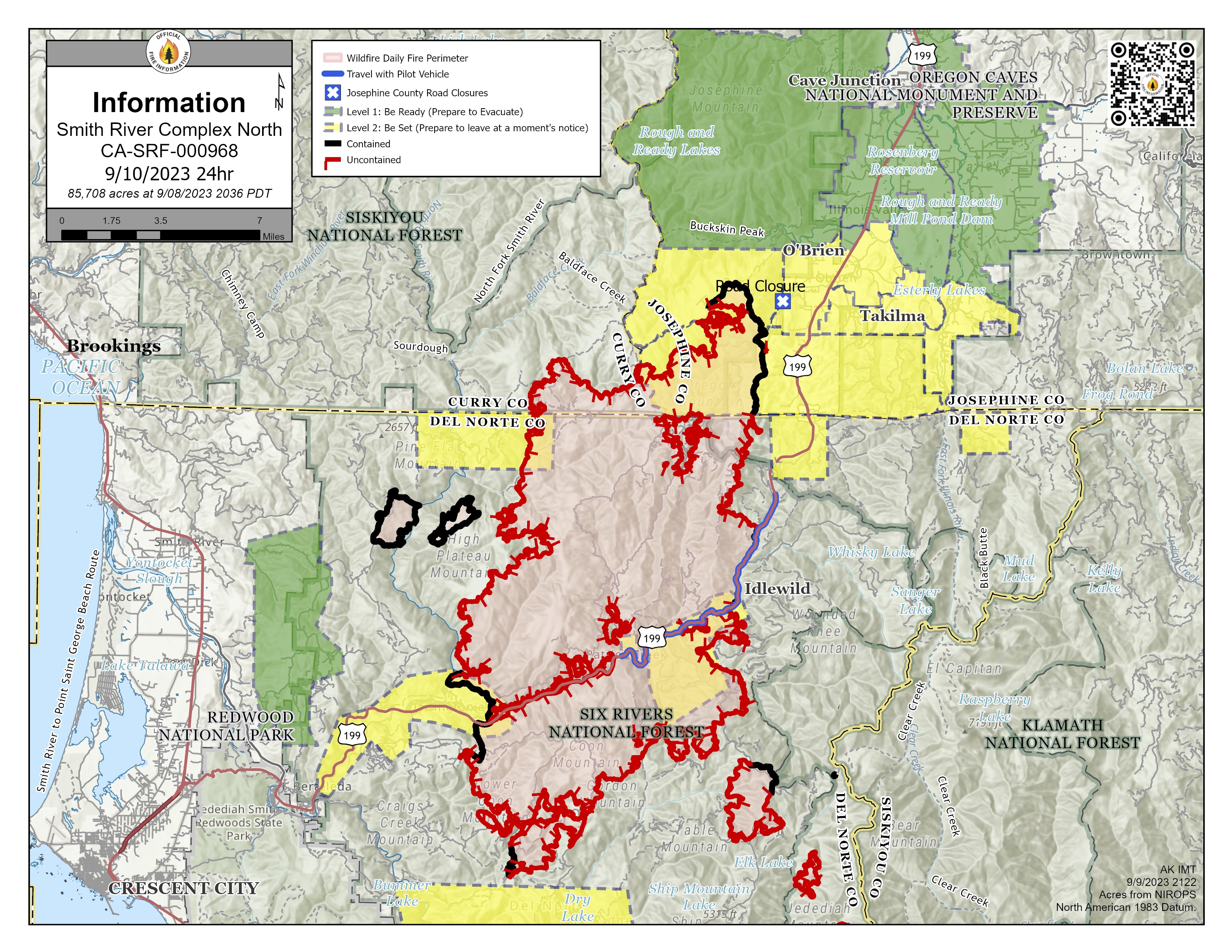
Informacin al da para el Incendio Smith River Complex North 10 de septiembre 2023
Related Incident: Smith River Complex
Publication Type: News
Área: 85,708 total/ 10,276 en Oregon
Inicio: 15 de agosto, 2023
Localizado: Grants Pass, OR
Contención: 20%
Personal: 2,012/Complex
Causa: Relampago
Recursos:
52 escuadrillas de bomberos
10 helicópteros
87 camiones de bomberos
16 buldóceres
29 cisternas
19 maquinaria masticadoras
2 cargadores compactos
Actividades durante el día de ayer: Se continúo realizando operaciones estratégicas de quema y de una manera exitosa en el lado Norte del Incendio Smith River Complex. Este Incendio está localizado cerca de la carretera forestal 019. Las operaciones de quema les permiten a los bomberos decidir en donde y cuando deberán enfrentar el incendio. Esto es una estrategia efectiva y segura para reducir el riesgo de incendio, combinado con el uso del terreno y las características naturales que reducen el avance de la parte principal del incendio. aunque todavía falta llevar a cabo un trabajo substancial de parte de la compañía Pacific Power, esta ha dado el primer paso para re-enegizar las líneas eléctricas y restablecer la electricidad en las comunidades afectadas. Para mayores detalles, lea la convocatoria en: tinyurl.com/PacificPowerNews.
Actividades para el día de hoy: Con la presencia de un calor persistente, clima seco y brisas ligeras, los bomberos esperan desarrollar operaciones de quema adicionales cerca del eje Norte del incendio. Las escuadrillas de bomberos desplazados en el lado Oeste del incendio están trabajando de forma unida para lograr introducir la maquinaria dentro del área de la carretera forestal 1106 y con la finalidad de desarrollar una línea de contingencia. Se prosigue con el monitoreo a lo largo del perímetro del incendio. Esto envuelve la búsqueda de fuentes de calor e improvisando las líneas del incendio. Otro grupo de bomberos trabajando arduamente en el lado Oeste, han iniciado la búsqueda de oportunidades para empezar las reparaciones de supresión o también para mitigar el daño causado por las actividades en el incendio y para minimizar el proceso potencial de erosión y el impacto causado por la misma.
Evacuaciones: Por favor monitoree el sitio para el Manejo de Emergencia de Rogue Valley y regístrese para el Sistema de Alertas y actualizaciones en rvem.org. También puede encontrar un Mapa Interactivo de Respuesta Inicial de Incendio, en donde se muestran las áreas de evacuación en la zona.
Condiciones de humo: Las perspectivas de pronostico del tiempo, están disponibles en: oregonsmoke.org
Ordenes de Cierre: El Bosque Nacional de Rogue River y la Agencia para el Manejo de Tierras (BLM) en el Distrito de Coos Bay, emitieron una Orden de Cierre para ciertas áreas y carreteras para el Incendio Smith River Complex. Se encuentra prohibido la utilización de fogatas en la Wild and Scenic Section de Rogue River. Para más información, visite el website del Servicio Forestal: https://bit.ly/RRSNFAlerts y también www.blm.gov/orwafire
La carretera US-199 se encuentra abierta y es el camino ideal para desplazarse en la zona. Aún permanecen vigentes los peligros causados por el incendio a lo largo del US-199. Por esta razón, el tráfico podría retrasarse intermitentemente entre 20 a 60 minutos, manejando sobre una sola línea de carretera y escoltados por un carro piloto. Por favor maneje con cautela, el trabajo de los bomberos es continuo. El Alguacil para la ciudad de Del Norte les pide a los residentes que eviten realizar viajes innecesarios a lo largo de la ruta mencionada
Por favor no siga el sistema de mapas que lo dirige hacia fuera del corredor del US-199; Esta ruta se localiza dentro de un área de incendio bajo una orden de cierre de carretera y no es recomendable para viajar. Esto
representa un peligro para Usted y para el personal de Incendio. Para información adicional acerca de las condiciones de carreteras, por favor lea roads.dot.ca.gov y también en el Departamento de Transporte de Oregon TripCheck site.
Orden de Restricción: Por favor respete la Orden Temporal de restricción de vuelos (TFR) establecida para el Incendio Smith River Complex; mantenga drones fuera de las operaciones de incendios. Si Usted vuela, nosotros no podemos. ¡No sea la razón por la cual las misiones aéreas tengan que ser desviadas! Informe detallado: tfr.faa.gov.
Forest Roads Reopened
Related Incident: El Valle Fire
Publication Type: Closures
Both Forest Road 207 and 714 have reopened.
Forest Road 207 reopened on Sep. 15 and Forest Road 714 on Sep. 18.
Updated Closure Order 0610282363
Related Incident: Anvil Fire
Publication Type: Closures
The Rogue River Siskiyou National Forest has issued a Forest Closure area due to the Anvil Fire (Order 06-10-28-23-63). Please see the attachment for more information.
EMERGENCY AREA AND ROAD CLOSURE – PRD Anvil Fire Closure
Pursuant to 16 USC § 36 CFR § 261.50(a) and (b), the following acts are prohibited upon general forest areas within the Rogue River-Siskiyou National Forest as described below and shown in Exhibit A. This Order will be effective beginning September 9, 2023, through October 31, 2023, unless rescinded sooner.
PROHIBITIONS:
- Being upon a closed road. [36 CFR § 261.54 (e)]
- Going into or being upon a closed area. [36 CFR § 261.52 (e)]
- Being on a trail. [36 CFR § 261.55(a)]
Area Closure boundary is described as: The entirety of the Grassy Knob Wilderness.
Road Closure is described as:
- FSR 5105 (Grassy Knob Road) from the Forest Boundary to the end of the road.
- FSR 5201-010 (China Peak) from the Forest Boundary to the end of the road.
- FSR 5201-011 (Pepper Ridge) from the 5201-10 road to the end of the road.
- FSR 5325 (Elk River Road) from the Forest Boundary to the 5201 road.
EXEMPTIONS:
Pursuant to 36 CFR § 261.50 (e), the following persons are exempt from this Order:
- Persons with Forest Service Permit No. FS-7700-48 (Permit for Use of Roads, Trails, or Areas Restricted by Regulation or Order), specifically exempting them from this Order.
- Any Federal, State, or local officer, or member of an organized rescue or firefighting force in the performance of an official duty.
This prohibition is in addition to the general prohibitions in 36 C.F.R. Part 261, Subpart A.
Violations of this prohibition is punishable by a fine of not more than $5,000 for an individual or $10,000 for an organization, or imprisonment for not more than 6 months, or both (16 USC § 551; 18 USC §§ 3551, 3571, and 3581).
Executed in Medford, Oregon, this 8th day of September 2023.
Sep 10 Update
Related Incident: El Valle Fire
Publication Type: News
Fire crews continued progress on the 521-acre El Valle Fire today, increasing containment to 32%. Continued work to strengthen lines and a change in weather prompted the Taos County Sheriff’s Department to lift all “Go” evacuations starting at 6:30 p.m., moving El Valle and Las Trampas to a “Set” status, using the Ready, Set, Go! system.
The full list of evacuation statuses is:
-
Set: Chamisal, El Valle, Las Trampas, Llano San Juan, Ojitos/Upper Ojitos and Ojo Sarco
-
Ready: Hodges, Rodarte, Santa Barbara and Truchas
“I want to thank the community for their patience with the evacuations,” said Incident Commander Fabian Montaño. “With the possibility of unpredictable winds, the unified team wanted to be extra careful before repopulating communities.”
Relative humidity substantially increased this afternoon with forecasted daytime humidities unconducive for significant fire activity for the rest of the week. An incoming cold front is expected to bring rain as early as this evening.
Despite the change in weather, fire personnel will continue to work toward full containment before calling the fire controlled and out. An infrared flight this morning (see video) showed heat through the burn area, where staff will also be monitoring for the potential of flooding from the burn area.
Highway 76 reopened this afternoon and Santa Barbara Campground is scheduled to reopen Monday afternoon.
The El Valle Fire was first reported at 12:49 p.m. on Sep. 8. Its cause remains under investigation.
This will be the last regular fire update unless there are significant changes in fire activity, however, important updates, including changes to evacuation statuses, will be provided in real-time, including when 100% containment is reached.
The public can check for fire updates on InciWeb, Carson National Forest social media (Facebook, X) and New Mexico Fire Information.
Moonshine Fire Daily Update September 10 2023
Related Incident:
Publication Type: News
Moonshine Fire
News - 09/10/2023
Size: 2,306 acres
Containment: 100%
Cause: Undetermined
Currently
At approximately 4:00 p.m. on Friday, Sept. 8, Texas A&M Forest Service received a request for assistance on a fire burning approximately 10 miles East of the town of Seymore, in Baylor County, Texas. The Cowlan Fire is burning in juniper and mesquite shrub as well as grass vegetation. The fire had exhibited extreme fire behavior making several runs with the column plume dominated.
Texas A&M Forest Service and Texas Intrastate Fire Mutual Aid System are working in unified command with local responders. Aircraft have assisted crews on the ground by making strategic drops of retardant and water to slow the flanks and head of the fire. Crews are working hard to construct containment line as several spotted thunderstorms in the area are creating sporadic wind shifts.
Today: Dozer crews tied in and improved all containment lines around the fire. Engine crews continued to patrol and mop up along the containment lines removing any hotspots that could potentially be a problem.
Weather and Fire Behavior: Light rain showers will be possible in the next couple hours which could bring wind gusts near 30 mph with erratic wind direction at times. Otherwise, mostly dry conditions are expected for the remainder of the day with relative humidity dropping into the 25-30% range during the afternoon. Expect a prevailing southeast wind direction at 15-20 mph through much of the day outside of shower or thunderstorm activity. Additional showers and storms are expected tonight into tomorrow morning.
Evacuations: Residents around Lake Kemp were evacuated yesterday, September 9th, but were allowed back in later that evening, no more evacuations took place after that.
Damages/Injuries: None at this time.
Closures: None at this time
Oregon Fire Update 9102023
Related Incident: Oregon Fire
Publication Type: News
Oregon Fire Update 9-10-2023
Fire Size: 10,817 acres
Initial Start: 8/18/2023 at 1600 pm
Location: Approximately 4 miles northeast of Elk, WA.
Cause: Human- Still under investigation
Containment: 95%
Resources Committed: 9 Engines, 5 Crews, 1 Bulldozer, 5 Water Tenders, 2 Skidgens, 3 Excavators
Personnel: 163
Road Closures: None
Elk, WA, - Current Situation: Northeast WA Incident Management Team 3 is in command of the Oregon and Gray fires. The Oregon Fire continues to remain within the current footprint with no further growth, the strategy remains full suppression and work is progressing as expected. Northeast WA Incident Management Team 3 will continue their efforts through the 11th before turning the fire back to local resources next week.
Today’s activities: Crews will continue to patrol the area, both on road and by foot, to find and mop-up any of those isolated heat sources. Those residing in and around the fire area will also start to see salvage logging and post fire clean up, by landowners, within in the fire perimeter. These activities will likely cause clouds of dust and ash that resemble smoke. While crews will continue to be working to the area and able to verify any new report of smoke, we are asking the public to be certain of a new fire before calling local dispatch centers or 911. As the team prepares to hand to the fire back to local resources in the near future, unverified reports put strain on local resources and their ability to respond to emergencies.
Weather: Today looks to be the warmest day since the high pressure system has been in place over the area. Winds will begin to slowly increase as a cold front moves into the area by Wednesday. Temperatures will moderate with the arrival of this cold front and as of now, there is no critical fire weather forecasted.
For fire information contact the Public Information Officer at 509-508-3323 or email 2023.oregon@firenet.gov
O 10 2023
Related Incident: Cowlitz Complex
Publication Type: News
Вторая группа по ликвидации происшествий в районе Скалистых гор
Джаред Хон (Jared Hohn) - руководитель работ по ликвидации чрезвычайной ситуации
Управление комплексными инцидентами в Скалистых горах второй группы переходит в понедельник, 11 сентября в 20.00 к калифорнийской группе 13.
Текущая ситуация: Уровень стабилизации в комплексе остается 12%, его общая площадь составляет 657 акров, задействовано 351 человек. К полудню ожидается облачная и прохладная погода, а сопутствующий морской бриз, предшествующий слабому холодному фронту, принесет к понедельнику более низкую температуру и моросящий дождь. Сегодня, в солнечные периоды может быть виден дым. Более теплая температура в середине недели может усилить пожароопасность в тех местах, где очаги возгорания потухли но восприимчивы к огню, а также где существует поверхностный огонь и на склонах, обращенных к югу. Северная сторона пожара на горе Грасси (Grassy Mountain) остается влажной и ожидается, что в ближайшие семь дней поведение пожара не изменится.
Пожары в филиале I/ дивизионе C/F находятся в режиме патрулирования и мониторинга. Пожарные на земле и ресурсы в воздухе, такие как IAA и UAS, обеспечат обнаружение и тушение любых сохраняющихся очагов возгорания.
В филиале II/ дивизионе L на пожаре Джекпот (Jackpot) медленно тушатся сложные очаги возгорания. На пожарах Снэгтус (Snagtooth) и Спенсер-Кварц (Spenser Quartz) завершены работы по строительству существующих дорожных систем. Сеть дорог будет использоваться в качестве удерживающего элемента в случае, если пожары будут продвигаться к объектам, находящимся под угрозой. В ближайшие несколько дней группа по защите строений оценит степень риска в этом районе. В ответ на первый вызов, поступивший от спасателей, было установлено, что это был дым от пожара Спенсер-Кварц (Spenser Quartz).
Сообщение о безопасности: В связи с официальным открытием охотничьего сезона, пожалуйста, будьте внимательны к пожарным, работающим в лесу.
Напоминание для общественности: Использование частных беспилотников в зоне пожара запрещено в соответствии с временными ограничениями полетов (TFR) к северу и югу от шоссе US-12. Этим вы рискуете замедлить успех, которого уже добились пожарные.
Ограничения по пожару: Действуют ограничения по пожару. В национальном лесу Гиффорд Пинчот (Gifford Pinchot National Forest) запрещено разжигать костры – разрешено использовать только ямы для костра, печи и фонари, работающие на пропане. Дополнительную информацию можно получить на сайте лесничества по адресу: Gifford Pinchot National Forest - Fire Management (usda.gov). Решение об отмене или сохранении ограничений на пожар зависит от таких факторов, как текущие и ожидаемые погодные условия, влажность очагов возгорания, уровень пожарной активности и наличие средств пожаротушения для реагирования на дополнительные возгорания.
Информация о погоде и дыме: Утром в долине ожидается туман, переходящий в солнечный день и ясное небо. В долине ожидается до 80 градусов, что является резким повышением температуры по сравнению с последними несколькими днями. В этих условиях можно ожидать усиления пожарной активности, что может привести к появлению дыма в воздухе.
Закрытия: В связи с продолжающейся пожарной активностью в районе пожара Снэгтус (Snagtooth) следующие дороги и тропы закрыты для публики для обеспечения общественной безопасности: Forest Roads 9300 и 9341, Boundary Trail #1 (от Элк-Пасс/Elk Pass до пересечения с Саммит-Прери/Summit Prairie), Summit Prairie #2, Craggy Peak #3, Snagtooth #4, Quartz #5, Stabler Camp #17, Wright Meadows #80, Basin Camp #3A, Quartz #5B, Quartz #5C (French Creek), Snyder Pasture #80A. Forest Road 8410 закрыта для пожарных и общественной безопасности в районе Pothole Fire, а Forest Road 78 временно закрыта между перекрестками 7802 и 2278 из-за попадания на проезжую часть опасного мусора.
Временные ограничения полетов: Действуют два временных ограничения на полеты (TRFs): один расположен к северу от US-12 до национального парка Маунт-Рейнир (Mount Rainier National Park), а новый TRF к югу от US-12 включает пожары Снэгтус (Snagtooth) и Спенсер-Кварц (Spencer Quartz). Противопожарное авиационное реагирование прекращается или задерживается в случае проникновения несанкционированного воздушного судна в TRF. Временные ограничения на полеты также распространяются на беспилотные авиационные системы и дроны. Если ты полетишь, то мы не сможем! Узнайте больше о том, как безопасно и ответственно использовать дроны на сайте Home - Know Before You Fly.