
Camp Creek Fire Daily Update for Monday September 11
Related Incident: Camp Creek Fire
Publication Type: News
Camp Creek Fire Update, Monday September 11
Fire Size: 2023 acres
Containment: 35%
Personnel: 521
Special Message:
At 8 p.m. tonight, Great Basin Team 1 will transfer command to the Pacific Northwest Team 3. Personnel from the incoming team are on-site today shadowing their counterparts on the outgoing team to implement a smooth transition.
Weather and Fire Behavior:
Yesterday was warm and dry but not quite as much as the previous day. A weak cold front will bring some cloud cover today but the change in weather will be subtle. The forecast predicts seasonally average temperatures and humidity levels with light winds through mid-week, then a warming trend into the weekend. On Friday, winds may shift from the west to the northeast. However, the wind speeds are not expected to be much above normal The fire continues to exhibit aggressive creeping and smoldering behavior. The potential for pockets of surface fire spread and isolated flare-ups exists where breezes are present. Smoke production is expected to continue due to increased fire activity and the use of limited tactical firing operations to bring fire edges to containment lines.
Operations:
The majority of the felling work being done to construct fuel breaks on primary and contingency lines around the fire area has been completed. On the remaining uncontained fireline along the FS12 road, firefighters have been removing hazard trees within the fire area. They will continue felling snags today so its safe for firefighters to enter the burned area to mop up. Line construction and securing the fire’s edge in the steep terrain between the FS12 and 14 roads on the west flank was successful yesterday, so they gained some containment on the line in that area. Crews completed the hand line direct on the fire’s edge on the south flank along the FS14 road yesterday. Today, they will install a hose lay so they can mop up the hand line. Heavy equipment will continue constructing contingency line in advance of the eastern flank of the fire. On the northeast flank, crews will continue mopping up the dozer and hand lines. That work is expected to take several more days.
Additional Information:
Current smoke outlook: https://outlooks.wildlandfiresmoke.net/outlook/2c7a8f9b.
Closures and Evacuations:
Barlow Wayside Park and the Sandy Ridge Recreation Site are temporarily closed due to fire activity. Clackamas County residents can sign up at https://www.clackamas.us/dm/publicalerts to receive emergency alerts via email, phone, or text.
Temporary Flight Restriction (TFR):
A TFR is issued over the fire area. It is illegal for the public to fly drones over or near wildfires because of the potential for accidents and disruption of suppression operations. Regardless of the fire, aircraft is not permitted to fly over the Bull Run Watershed Management Unit.
Video:
YouTube video link: Camp Creek Fire Operations Briefing Monday, September 11 (6:14)
South Fork Complex Update September 11 2023
Related Incident: South Fork Complex
Publication Type: News
South Fork Complex Update
Monday, September 11, 2023
Fire Information: 530-330-5450, 8 a.m. to 8 p.m.
Email: 2023.southforkcomplex@firenet.gov
Linktree: linktr.ee/southforkcomplex2023
3-9 Fire: 2,840 acres with 80% containment
Pellitreau Fire: 3 acres with 100% containment
Pilot Fire: 1,055 acres with 100% containment
Sulphur Fire: 31 acres with 100% containment
3,929 acres and 85% overall containment for the South Fork Complex
A total of 581 personnel, crews, air support, engines, dozers, and water tenders support the incident.
3-9 Fire – The fire continues to show a reduction in heat sources. Mop-up continues as more black lines are established on the fire perimeter. Aircraft will continue to support crews on the fire line with water dropping missions and the removal of hose and equipment. Crews will continue to complete the remaining portions of the open line and focus on strengthening these lines by mopping up well into the burn area to ensure there is no threat of roll out or escape. Crews will also be looking for opportunities to begin suppression repair along the perimeter.
The Pilot Fire is 100% contained. Crews will continue to patrol the fire perimeter to ensure that the fire remains within the containment lines. Suppression repair will continue along the fire perimeter.
The Pellitreau Fire and the Sulfur Fire are 100% contained. Firefighters continue to patrol the fires periodically to ensure fire remains within containment lines.
Weather: A passing cold front to the north will sag south far enough to where some intrusion of winds from the coast will impact the ridge tops over the fire. Terrain driven winds will continue through Sunday with speeds of 18-22 mph. Temperatures will be in the upper 70s through the next couple of days. Minimum relative humidities are expected to be in the middle 20% range. The passing disturbance to the north will allow for slightly more cloud cover as well.
Forest Closure: Forest Closure orders for the South Fork Complex Fire continue to be in effect and are posted on the Shasta-Trinity National Forest and the Six Rivers National Forest websites. Please avoid closed areas.
2023 SRF Lightning Complex and Redwood Lightning Complex Update 91123
Related Incident: 2023 SRF Lightning Complex and Redwood Lightning Complex
Publication Type: News
Fire Update
2023 SRF Lightning Complex & Redwood Lightning Complex
Monday, September 11, 2023 – 9:00 a.m.
Rocky Mountain Complex Incident Management Team 1
Dan Dallas, Incident Commander
Information Phone: 530-536-0767
Email: 2023.lightningcomplex@firenet.gov
Information Staffing Hours: 8 am to 8 pm
Special Note: This update covers 9 of the 20 fires being managed as part of the Complexes. The remaining 11 fires are listed in the accompanying Complex Overview. Those fires, totaling 1,748 acres, are contained and in patrol status. They are checked daily, and their size and containment are unlikely to change.
Current Situation: The 20 fires in this incident total 18,910 acres and overall containment is 18%. The decrease in containment is due to remapping of multiple “fingers” on the fire edges which have a long perimeter but small area, affecting containment percentage calculations. The fires described below total 17,161 acres. Lost Fire is in Redwood National and State Parks. All other fires described in this update are in Six Rivers National Forest. A total of 1,050 personnel are assigned to the incident. Current fire, weather, and fuels conditions on the 2023 SRF Lightning Complex are approaching optimum for using carefully managed fire as a tool to accomplish fire suppression and fuels reduction objectives. Agency administrators and fire managers, in consultation with tribal leaders, are prepared to implement a Strategic Firing Plan with the objectives of suppressing the current fires while reducing fuels to lessen future fire occurrence or intensity in the area. A Firing Group has been assembled to take advantage of strategic firing opportunities throughout the Complex as conditions allow.
Lost Fire (740 acres, 100% contained) – This fire is now 100% contained. It will be dropped from future fire updates but will remain on the Complex Overview. The only work remaining on the fire is ongoing suppression repair of dozer and hand firelines.
Pearch Fire (5430 acres, 8% contained) – Crews continue to patrol completed firelines and mop up and secure the fire perimeter as needed. Backhauling and staging of surplus supplies and equipment is underway. Yesterday, the Firing Group conducted a minor firing operation to complete the filling in of a 80-90 acre pocket of fuels on the west side of the fire. An area of active heat continues to back downslope into the Butler Creek drainage on the eastern side of the fire. Firefighters are aware of this activity and are watching the area throughout each day. There are currently no threats, and no action is needed at this time. The structure protection group remains in the area and a night shift of engines continues to work the Pearch Fire.
Bluff #1 (2169 acres, 26% contained) and Mosquito (2681 acres, 24% contained) Fires – Hand crews, dozers, masticators, and chippers have nearly completed constructing a containment “box” of direct and indirect containment lines around the fires. Fire managers plan to use both aerial and hand strategic firing operations to complete the objective of full suppression of these fires, while also reducing excess fuels to lessen the occurrence or intensity of future fires. Test firing has occurred the past two days, and fuels are nearing optimal conditions for proceeding to full implementation of firing plans. Implementation will be slow and methodical over multiple days to allow monitoring of effectiveness and to make adjustments as needed. Residents can expect to see more smoke during these firing operations. This is an expected result and not an indicator that the fires have escaped or present a threat. This operation has been carefully planned and coordinated with cooperating agencies and tribal leaders. Work on these two fires, as well as others in the Complex, is being closely coordinated with tribal resource advisors to ensure that important cultural and historical resources are protected and traditional indigenous cultural and ecological practices are respected.
As work on the “box” described above nears completion, crews are now working on additional priorities in Branch XX. Masticators are performing brush removal work on the Nickowitz Road, and this work should last another 5-6 days. The Firing Group did not conduct firing operations on Bluff #1 Fire yesterday, but they did perform firing operations on 80 acres of a flat bench near the southeastern corner of Mosquito Fire. This work will continue today.
Blue Creek #2 (3470 acres, 0% contained), Marlow (1577 acres, 0% contained), and Copper (1012 acres, 0% contained) Fires – These fires are being patrolled by aerial resources as weather conditions allow. They are bounded by indirect control lines to the east and south, and significant growth of these fires is not expected.
Monument (2 acres, 0% contained) and Let er-Buck (79 acres, 0% contained) Fires – Due to limited values at risk, the remote, steep terrain and associated safety concerns for our firefighters, and the low probability of success using standard suppression tactics, these fires are being addressed with a confinement strategy. Terrain, natural fire barriers such as rock outcroppings, and old fire footprints where fuels are limited will be used to confine fire growth until season ending precipitation extinguishes the fires. These fires are checked regularly by aerial patrols to ensure they remain within acceptable bounds, and little to no fire growth has been observed.
Weather: Increasing onshore winds will allow for a trend of slight cooling and higher humidity for much of the Complex. Highs over the fires will range from the 70s to 80s. Winds will be mostly westerly. A warming and drying trend will return Wednesday through Friday.
For information on Closures, Evacuations, and Alert Notifications please see the accompanying Complex Overview.
Fire Information Contacts
Phone: 530-536-0767 | Email: 2023.lightningcomplex@firenet.gov
InciWeb: https://inciweb.nwcg.gov/incident-information/casrf-2023-srf-lightning-complex
Facebook: https://www.facebook.com/2023SRFRedwoodLightning
Redwood National and State Parks Information Hotline: Phone: 707-464-6101
https://www.nps.gov/redw/planyourvisit/conditions.htm
Hoopa Information Hotline: Phone: 530-618-2995 | Email: serene.oes@gmail.com
More Fire Information Links: www.linktr.ee/srffirepio
NOTE: For information about the Elliot or Hancock Fires which are part of the
Happy Camp Complex, please visit https://linktr.ee/happycampcomplex2023 .
Daily Fire Update September 11th
Related Incident: Bear Creek Fire
Publication Type: News
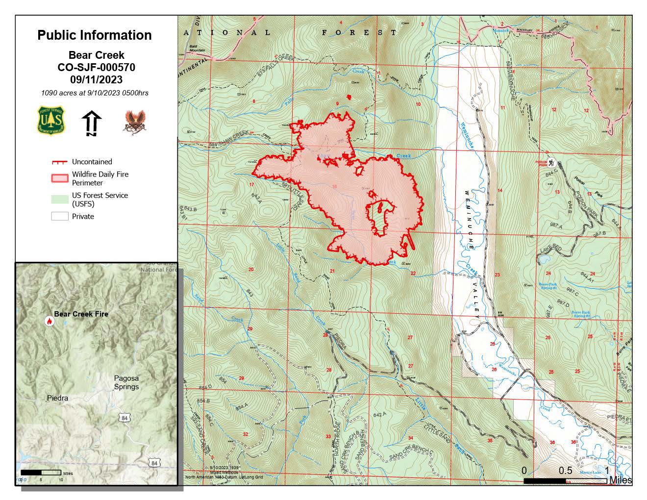
BEAR CREEK FIRE
September 11, 2023
Type 3 Team, Incident Commander: Nate Hallam
Daily Update – 9:00 AM
Highlights:
Both the Quartz Ridge and Bear Creek fires had minimal to moderate fire activity yesterday. The Bear Creek fire received a few rain showers, though less fell over Quartz Ridge. With increased moisture in the forecast, smoke will mostly be localized to the valleys nearest the fires, with moderate impacts to Pagosa Springs and the San Juan Mountains. However, the Colorado Department of Health is not issuing any Air Quality Advisories for the area today (9/11). Fire activity on both fires is expected to decrease as weather comes in this week.
Bear Creek Fire: 1090 acres| 83% of objectives achieved | 61 personnel assigned
Yesterday, the Bear Creek Fire saw moderate fire activity mid-morning, until afternoon showers brought wetting moisture to slow fire activity. More showers overnight brought 24-hour rain totals to 0.41”, but prevented a mapping flight, so there is not a new acreage to report today. Crews will remain actively engaged in the Weminuche Valley and prepping the Mosca road as a contingency line today, though minimal fire activity is expected with continued moisture through mid-week.
Weather: Yesterday was very dry, although weather had changed overnight with fair humidity recovery. Today, the area will be out of critical periods of dryness and will experience a cooler trend through the week. There will be higher humidity today, around 25%, as well as an increase in thunderstorms, although there is a low chance of wetting rains. There is evidence of possible virga, rain that evaporates before it hits the ground.
San Juan National Forest Temporary Closures: Closure orders are in effect and additional information can be found here: Quartz Ridge Closure and Bear Creek Closure. The trails within the Bear Creek Fire area are Little Sand Trail (NFST #591) and Shaw Creek Trail (NFST#584).
Lions Camp Road Fire Daily Update 91123
Related Incident: Lions Camp Road Fire
Publication Type: News
Louisiana Statewide Burn Ban: As a reminder, the active State Fire Marshal’s Office’s burn ban order prohibiting ALL private burning, with no limitations, remains in effect. As does the corresponding burn ban from the Louisiana Department of Agriculture and Forestry prohibiting all agricultural burning, including but not limited to prescribed burning. However, Louisiana residents can resume outdoor cooking with safety measures in place. See http://sfm.dps.louisiana.gov/doc/press/pr_2023-36.pdf for more information. The use of open flames in fire pits, campfires, barrels, bonfires, burn piles, and like open burning is still prohibited. Citations and arrests ARE happening across this state in partnership with local and state law enforcement agencies.
Personnel and Equipment:
Tiger Island: 1 Type-2 Crew; 22 Type-6 Engines; 1 Dozer; 1 Type-2 Tractor Plow Unit; 7 Type-3 Tractor Plow Units; 3 Water Tenders; 3 Ambulances.
Hwy 113: 1 Type-1 Crew; 15 Type-6 Engines; 5 Type-2 Tractor Plow Units; 6 Type-3 Tractor Plow Units; 3 Water Tenders.
Lions Camp Road: 1 Type-6 Engine; 3 Type-3 Tractor Plow Units and 1 Ambulance.
Elizabeth: 7 Type-6 Engines; 6 Type-3 Tractor Plow Units; 1 Water Tender and 1 Ambulance.
Air Resources Assigned to all Fires: 5 Helicopters and 2 Air Attacks.
Additional support is being provided to all fires by Parish authorities and departments, the Governor’s Office of Homeland Security and Emergency Preparedness, Sheriff’s offices, and the Offices of Emergency Preparedness.
Tiger Island Fire: The Tiger Island Fire was first reported on Tuesday, August 22nd. The fire is located East of Merryville, south of Hwy 190, SW of DeRidder and North of Singer. The fire is burning in pine plantations of multiple ages. Heavy residual fuels because of Hurricane Laura in 2020 exist and contribute to extreme fire behavior.
Operations: The Tiger Island Fire is currently 71% contained. Removing needlecast from containment lines remains a top priority. Needlecast has continued throughout the fire area, allowing for reburn and smoke. Reburn was present around the entire fire area yesterday and is expected to continue today. Today, crews will mitigate needlecast around the fire perimeter, utilizing dozers to scrape lines clean and leaf blowers to blow away needles. Crews will continue to utilize infrared imagery to seek out hot spots for mop up, and search for new hot spots from Friday’s lightning.
Hwy 113 Fire: Located 14 miles northwest of Oakdale. This fire is burning in loblolly pines and hardwoods.
Operations: The Hwy 113 fire is currently 63% contained. Removing needlecast from containment lines was high priority yesterday and will continue today. Also, crews created additional fireline within the interior of the fire perimeter to slow down reburn. Roads and dozer lines continue to dry out and allow for easier access. Today, crews will examine creekbeds and stream crossings to identify any areas that need temporary repairs, as well as utilize infrared imagery to ground truth and target hot spots for mop up. The Tenmile Creek drainage remains a priority for mop up on the north and south end of the fire.
Lions Camp Road: Five miles northwest of Leesville. This fire is burning in southern rough, timber and brush.
Operations: The Lions Camp Road Fire is currently 83% contained. Yesterday, crews patrolled containment lines and mitigated needlecast. Reburn within the interior of the fire occurred mid-day and smoke was visible, but there was no threat to containment lines. Today, crews will keep containment lines clear of pine needles. They will continue to use infrared imagery to target specific hot spots.
Elizabeth: Located in southwest Rapides Parish. The fire is south of Ten Mile Road and northeast of state Louisiana Hwy 462.
Operations: The Elizabeth Fire is 72% contained. Yesterday, there were still hotspots within the interior of the fire. Combined with needlecast, fuels within the interior are increasing, causing reburn. Fire crews continue to monitor perimeter lines and mop up. Today, crews will continue mop up, targeting areas further to the interior of the containment line.
Weather and Fire Behavior: Relative humidity will stay critically low today, dropping to 25% in some areas. Temperatures will also be high, with a maximum of 96 degrees. Winds will be light and variable, with gusts in the teens. The hot and dry conditions will lead to active fire behavior and increase the possibility of reburn. Fuel moisture remains extremely low, including live and dead fuels. Drought conditions will remain critical until a large rainfall event.
Air Quality: Smoke reports are no longer being produced for these fires. Smoke will remain present from interior reburn or any new starts. For real time air quality information see EPA's Fire and Smoke Map: https://fire.airnow.gov/.
Temporary Flight Restriction: A Temporary Flight Restriction (TFR) is in place over the Tiger Island Fire and Hwy 113 and Elizabeth Fire areas. This is necessary to protect aerial operations. If you fly, we can’t. If there are drone intrusions into the Temporary Flight Restrictions, we must ground all aircraft.
Hwy 113 Fire Daily Update 91123
Related Incident:
Publication Type: News
Louisiana Statewide Burn Ban: As a reminder, the active State Fire Marshal’s Office’s burn ban order prohibiting ALL private burning, with no limitations, remains in effect. As does the corresponding burn ban from the Louisiana Department of Agriculture and Forestry prohibiting all agricultural burning, including but not limited to prescribed burning. However, Louisiana residents can resume outdoor cooking with safety measures in place. See http://sfm.dps.louisiana.gov/doc/press/pr_2023-36.pdf for more information. The use of open flames in fire pits, campfires, barrels, bonfires, burn piles, and like open burning is still prohibited. Citations and arrests ARE happening across this state in partnership with local and state law enforcement agencies.
Personnel and Equipment:
Tiger Island: 1 Type-2 Crew; 22 Type-6 Engines; 1 Dozer; 1 Type-2 Tractor Plow Unit; 7 Type-3 Tractor Plow Units; 3 Water Tenders; 3 Ambulances.
Hwy 113: 1 Type-1 Crew; 15 Type-6 Engines; 5 Type-2 Tractor Plow Units; 6 Type-3 Tractor Plow Units; 3 Water Tenders.
Lions Camp Road: 1 Type-6 Engine; 3 Type-3 Tractor Plow Units and 1 Ambulance.
Elizabeth: 7 Type-6 Engines; 6 Type-3 Tractor Plow Units; 1 Water Tender and 1 Ambulance.
Air Resources Assigned to all Fires: 5 Helicopters and 2 Air Attacks.
Additional support is being provided to all fires by Parish authorities and departments, the Governor’s Office of Homeland Security and Emergency Preparedness, Sheriff’s offices, and the Offices of Emergency Preparedness.
Tiger Island Fire: The Tiger Island Fire was first reported on Tuesday, August 22nd. The fire is located East of Merryville, south of Hwy 190, SW of DeRidder and North of Singer. The fire is burning in pine plantations of multiple ages. Heavy residual fuels because of Hurricane Laura in 2020 exist and contribute to extreme fire behavior.
Operations: The Tiger Island Fire is currently 71% contained. Removing needlecast from containment lines remains a top priority. Needlecast has continued throughout the fire area, allowing for reburn and smoke. Reburn was present around the entire fire area yesterday and is expected to continue today. Today, crews will mitigate needlecast around the fire perimeter, utilizing dozers to scrape lines clean and leaf blowers to blow away needles. Crews will continue to utilize infrared imagery to seek out hot spots for mop up, and search for new hot spots from Friday’s lightning.
Hwy 113 Fire: Located 14 miles northwest of Oakdale. This fire is burning in loblolly pines and hardwoods.
Operations: The Hwy 113 fire is currently 63% contained. Removing needlecast from containment lines was high priority yesterday and will continue today. Also, crews created additional fireline within the interior of the fire perimeter to slow down reburn. Roads and dozer lines continue to dry out and allow for easier access. Today, crews will examine creekbeds and stream crossings to identify any areas that need temporary repairs, as well as utilize infrared imagery to ground truth and target hot spots for mop up. The Tenmile Creek drainage remains a priority for mop up on the north and south end of the fire.
Lions Camp Road: Five miles northwest of Leesville. This fire is burning in southern rough, timber and brush.
Operations: The Lions Camp Road Fire is currently 83% contained. Yesterday, crews patrolled containment lines and mitigated needlecast. Reburn within the interior of the fire occurred mid-day and smoke was visible, but there was no threat to containment lines. Today, crews will keep containment lines clear of pine needles. They will continue to use infrared imagery to target specific hot spots.
Elizabeth: Located in southwest Rapides Parish. The fire is south of Ten Mile Road and northeast of state Louisiana Hwy 462.
Operations: The Elizabeth Fire is 72% contained. Yesterday, there were still hotspots within the interior of the fire. Combined with needlecast, fuels within the interior are increasing, causing reburn. Fire crews continue to monitor perimeter lines and mop up. Today, crews will continue mop up, targeting areas further to the interior of the containment line.
Weather and Fire Behavior: Relative humidity will stay critically low today, dropping to 25% in some areas. Temperatures will also be high, with a maximum of 96 degrees. Winds will be light and variable, with gusts in the teens. The hot and dry conditions will lead to active fire behavior and increase the possibility of reburn. Fuel moisture remains extremely low, including live and dead fuels. Drought conditions will remain critical until a large rainfall event.
Air Quality: Smoke reports are no longer being produced for these fires. Smoke will remain present from interior reburn or any new starts. For real time air quality information see EPA's Fire and Smoke Map: https://fire.airnow.gov/.
Temporary Flight Restriction: A Temporary Flight Restriction (TFR) is in place over the Tiger Island Fire and Hwy 113 and Elizabeth Fire areas. This is necessary to protect aerial operations. If you fly, we can’t. If there are drone intrusions into the Temporary Flight Restrictions, we must ground all aircraft.
Daily Fire Update September 11th
Related Incident: Quartz Ridge Fire
Publication Type: News
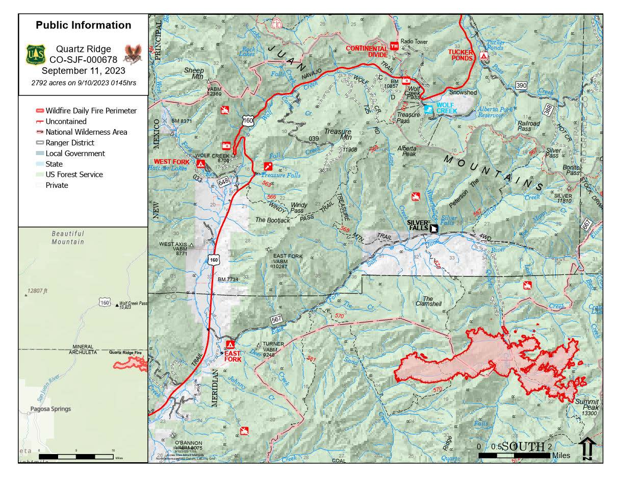
QUARTZ RIDGE FIRE
September 11, 2023
Type 3, Incident Commander: Nate Hallam
Daily Update - 9:00AM
Highlights:
Both the Quartz Ridge and Bear Creek fires had minimal to moderate fire activity yesterday. The Bear Creek fire received a few rain showers, though less fell over Quartz Ridge. With increased moisture in the forecast, smoke will mostly be localized to the valleys nearest the fires, with moderate impacts to Pagosa Springs and the San Juan Mountains. However, the Colorado Department of Health is not issuing any Air Quality Advisories for the area today (9/11). Fire activity on both fires is expected to decrease as weather comes in this week.
Quartz Ridge Fire: 2,792 acres | 77% of objectives achieved | 68 personnel assigned
The Quartz Ridge Fire saw the most activity on the eastern side of the fire yesterday. Cloud cover prevented a mapping flight, so there is not a new acreage to report today. While little wetting rain reached the fire yesterday, it received 0.37” of rain overnight and increased moisture and humidities are expected to keep fire behavior minimal today. With structure protection operations completed, crews are now focusing on constructing a shaded fuel break as a contingency line to protect private property.
Weather: Relative humidities got as low as 20% yesterday but rebounded as afternoon showers and clouds increased over the fires. A surge of moisture will bring widespread showers and thunderstorms through at least Wednesday, with the greatest chance of wetting rains expected on Tuesday. This increased moisture will keep fire activity minimal.
San Juan National Forest Temporary Closures: Closure orders are in effect and additional information can be found here: Quartz Ridge Closure and Bear Creek Closure. Roads and trails within the Quartz Ridge Fire area are Quartz Meadows Rd (NFSR#684), Quartz Ridge Trail (NFST#570), and Quartz Creek Trail (NFST#571). The closed trails within the Bear Creek Fire area are Little Sand Trail (NFST #591) and Shaw Creek Trail (NFST#584).
Flat Fire and Anvil Fire Morning Update 09112023
Related Incident: Flat FireAnvil Fire
Publication Type: News
The Rogue River-Siskiyou National Forest (RRSNF) has issued an updated closure order for the Anvil Fire (06-10-28-23-63). Visit https://bit.ly/RRSNFAlerts for Flat and Anvil Fire closure information.
Anvil Fire Activity
Size: 451 acres Start Date: August 25, 2023 Point of origin: 8 miles east of Port Orford, OR
Containment: 0% Total personnel: 283
Resources: 8 crews, 3 helicopters, 4 engines, 5 water tenders, 4 pieces of heavy equipment
Helicopters dropped 149,450 gallons of water on the fire yesterday. Wildland Fire Module (WFM) crew members are helping direct helicopter bucket drops and collecting weather and fuels data. The WFMs are also scouting for alternate lines on the north and south sides of the wilderness boundary. On the north, a location for containment line has been identified that will start slightly southeast of China Peak and extend northwest onto tribal and BLM land. Crews began tracking a dozer into that area today. The Coos Forest Protective Association will construct this fireline where it goes across private, tribal, and BLM land. Crews are still working along with the masticator operator along Grassy Knob Road to the forest boundary to finish clearing vegetation along the road for use as a control line if needed. Interagency Hotshot Crews, dozer and excavator operators worked on the north piece of the Grassy Knob Road to Elk River Road fireline. Fire managers expect completion on this line to take several days. Firefighters continue to improve the lines around the fish hatchery. Structure protection crews are beginning to install sprinkler systems with hoses and pumps at residences along Elk River Road. Fire managers are ordering additional firefighting resources. The fire currently remains north of Red Cedar Creek, east of Anvil Creek, and south of a Dry Creek tributary.
Flat Fire Activity
Size: 34,242 acres Start Date: July 15, 2023 Point of origin: 2 miles southeast of Agness, OR
Containment: 75% Total personnel: 284
Resources: 5 crews, 3 helicopters, 12 engines, 7 water tenders, 6 pieces of heavy equipment
Suppression repair work continues, including pulling in dozer line berms, seeding, mulching, installing water bars, and chipping branches and small trees that were cut and stacked during active suppression efforts. Heat signatures continue to show up on infrared flights and crews are addressing any that are near containment lines. Firefighters are watching interior pockets that continue to burn, especially those near the eastern, uncontained side.
Weather: A weak cold front moved into the area overnight, bringing cooler air, higher humidity, and some drizzles in the morning, which should moderate fire behavior. A weather shift is expected to bring increased winds starting mid-week.
Smoke: Visit https://fire.airnow.gov/ for current smoke and air quality updates.
Closures: U.S. Highway 199 was closed overnight due to a rockslide 3 miles south of Patrick Creek but is scheduled to be reopened this morning at 10:00. There is still a pilot car system operating, expect 20-40 minute delays. Local law enforcement cautions against any non-essential traffic along this route. Navigation apps and mapping programs have been routing travelers into active fire areas. Check www.tripcheck.com in Oregon and www.quickmap.dot.ca.go in California for current closures and detours. Do not use forest roads for alternate routes.
Evacuations: Level 1 “Get Ready” evacuation status is in place for areas near the Flat Fire. Level 2 “Get Set“ evacuation status is in place along the Elk River from about milepost four to the USFS Butler Bar Campground near the Anvil Fire. Sign up for Curry Co. emergency alerts at https://bit.ly/CurryCoEM.
Restrictions: The RRSNF decreased fire danger from Extreme to High and the Industrial Fire Precaution Level from Level 3 to Level 2, effective Sept. 5, 2023. Public Use Restrictions (PUR) remain at Stage 3 across the forest and on the Wild Section of the Rogue National Wild and Scenic River. Visit https://bit.ly/RRSNFAlerts for more information. There is a Temporary Flight Restriction (TFR) over the fire areas. Please do not fly unmanned aircraft (drones) in the fire vicinity. If you fly, we can't.
Gist Road Fire Daily Update September 11 2023
Related Incident:
Publication Type: News
Gist Road Forest Fire Daily Update
September 11, 2023
9:30 am
Size: 600 acres
Containment: 50%
Start Date: September 10, 2023
Cause: Under Investigation
Texas A&M Forest Service received a request for assistance from Jasper County for a fire on County Road 826, 12 miles northeast of Beaumont, Texas.
In coordination with local fire departments, crews from Texas A&M Forest Service and several aviation resources were engaged in suppression efforts yesterday. Two Type 1 helicopters and several fixed-winged aircraft took action to assist ground resources in slowing the fire’s progression and providing structure protection.
Crews continued to construct containment lines throughout the night. Dozer lines were completed around the fire after midnight and engines continued to patrol until this morning.
Fresh crews are back on scene today to relieve the night shift and plan to improve existing containment lines while patrolling the area for spot fires. Aviation resources have been ordered for today to assist in operations.
Weather:
A high-pressure build brings northerly winds yielding relative humidity values ranging from 20-30% for today. Southerly winds will return this afternoon increasing the relative humidity for Tuesday and throughout the week. Isolated showers and thunderstorms will return as well on Tuesday with increased chances through the rest of the week.
Evacuations:
Evacuations were ordered for residents on Blankenship Road as well as residents 1 mile East and West of the same road and 1/2-mile South of Texla Road. The evacuation order was lifted after midnight. There are no evacuations at this time.
Closures:
There are no road closures at this time.
Damages and Injuries:
Currently, there have been no reports of injuries from the public or first responders.
Elizabeth Fire Daily Update 09112023
Related Incident: Elizabeth Fire
Publication Type: News
Daily fire update 09-11-23
Hours: 8 am-8 pm Phone: 318-239-9263
Email: 2023.TigerIsland@firenet.gov
InciWeb:
Tiger Island Fire: https://inciweb.nwcg.gov/incident-information/lalas-tiger-island-fire
Hwy 113 Fire: https://inciweb.nwcg.gov/incident-information/lalas-hwy-113-fire
Lions Camp Road Fire: https://inciweb.nwcg.gov/incident-information/lalas-lions-camp-road-fire
Elizabeth Fire: https://inciweb.nwcg.gov/incident-information/lalas-elizabeth-fire
Facebook:
Tiger Island Fire: https://www.facebook.com/TigerIslandFire
Hwy 113 & Lions Camp Road Fire: https://www.facebook.com/113andLionsCamp
Elizabeth Fire: https://www.facebook.com/ElizabethFireLa
Louisiana Statewide Burn Ban: As a reminder, the active State Fire Marshal’s Office’s burn ban order prohibiting ALL private burning, with no limitations, remains in effect. As does the corresponding burn ban from the Louisiana Department of Agriculture and Forestry prohibiting all agricultural burning, including but not limited to prescribed burning. However, Louisiana residents can resume outdoor cooking with safety measures in place. See http://sfm.dps.louisiana.gov/doc/press/pr_2023-36.pdf for more information. The use of open flames in fire pits, campfires, barrels, bonfires, burn piles, and like open burning is still prohibited. Citations and arrests ARE happening across this state in partnership with local and state law enforcement agencies.
Personnel and Equipment:
Tiger Island: 1 Type-2 Crew; 22 Type-6 Engines; 1 Dozer; 1 Type-2 Tractor Plow Unit; 7 Type-3 Tractor Plow Units; 3 Water Tenders; 3 Ambulances.
Hwy 113: 1 Type-1 Crew; 15 Type-6 Engines; 5 Type-2 Tractor Plow Units; 6 Type-3 Tractor Plow Units; 3 Water Tenders.
Lions Camp Road: 1 Type-6 Engine; 3 Type-3 Tractor Plow Units and 1 Ambulance.
Elizabeth: 7 Type-6 Engines; 6 Type-3 Tractor Plow Units; 1 Water Tender and 1 Ambulance.
Air Resources Assigned to all Fires: 5 Helicopters and 2 Air Attacks.
Additional support is being provided to all fires by Parish authorities and departments, the Governor’s Office of Homeland Security and Emergency Preparedness, Sheriff’s offices, and the Offices of Emergency Preparedness.
Tiger Island Fire: The Tiger Island Fire was first reported on Tuesday, August 22nd. The fire is located East of Merryville, south of Hwy 190, SW of DeRidder and North of Singer. The fire is burning in pine plantations of multiple ages. Heavy residual fuels because of Hurricane Laura in 2020 exist and contribute to extreme fire behavior.
Operations: The Tiger Island Fire is currently 71% contained. Removing needlecast from containment lines remains a top priority. Needlecast has continued throughout the fire area, allowing for reburn and smoke. Reburn was present around the entire fire area yesterday and is expected to continue today. Today, crews will mitigate needlecast around the fire perimeter, utilizing dozers to scrape lines clean and leaf blowers to blow away needles. Crews will continue to utilize infrared imagery to seek out hot spots for mop up, and search for new hot spots from Friday’s lightning.
Hwy 113 Fire: Located 14 miles northwest of Oakdale. This fire is burning in loblolly pines and hardwoods.
Operations: The Hwy 113 fire is currently 63% contained. Removing needlecast from containment lines was high priority yesterday and will continue today. Also, crews created additional fireline within the interior of the fire perimeter to slow down reburn. Roads and dozer lines continue to dry out and allow for easier access. Today, crews will examine creekbeds and stream crossings to identify any areas that need temporary repairs, as well as utilize infrared imagery to ground truth and target hot spots for mop up. The Tenmile Creek drainage remains a priority for mop up on the north and south end of the fire.
Lions Camp Road: Five miles northwest of Leesville. This fire is burning in southern rough, timber and brush.
Operations: The Lions Camp Road Fire is currently 83% contained. Yesterday, crews patrolled containment lines and mitigated needlecast. Reburn within the interior of the fire occurred mid-day and smoke was visible, but there was no threat to containment lines. Today, crews will keep containment lines clear of pine needles. They will continue to use infrared imagery to target specific hot spots.
Elizabeth: Located in southwest Rapides Parish. The fire is south of Ten Mile Road and northeast of state Louisiana Hwy 462.
Operations: The Elizabeth Fire is 72% contained. Yesterday, there were still hotspots within the interior of the fire. Combined with needlecast, fuels within the interior are increasing, causing reburn. Fire crews continue to monitor perimeter lines and mop up. Today, crews will continue mop up, targeting areas further to the interior of the containment line.
Weather and Fire Behavior: Relative humidity will stay critically low today, dropping to 25% in some areas. Temperatures will also be high, with a maximum of 96 degrees. Winds will be light and variable, with gusts in the teens. The hot and dry conditions will lead to active fire behavior and increase the possibility of reburn. Fuel moisture remains extremely low, including live and dead fuels. Drought conditions will remain critical until a large rainfall event.
Air Quality: Smoke reports are no longer being produced for these fires. Smoke will remain present from interior reburn or any new starts. For real time air quality information see EPA's Fire and Smoke Map: https://fire.airnow.gov/.
Temporary Flight Restriction: A Temporary Flight Restriction (TFR) is in place over the Tiger Island Fire and Hwy 113 and Elizabeth Fire areas. This is necessary to protect aerial operations. If you fly, we can’t. If there are drone intrusions into the Temporary Flight Restrictions, we must ground all aircraft.