
Sourdough Fire Update
Related Incident:
Publication Type: News
With the recent warm and dry weather conditions there is increased fire behavior on the Sourdough Fire, primarily on the north and east flanks. The Sourdough Fire is at 6,369 acres and 25% containment. There will be no change in containment percentage until significant rain or snow, known as a season ending event. Containment areas of the fire are in place around State Route 20, structures, and other values at risk.
The fire is currently active in rough, steep terrain. Firefighters continue to patrol and monitor areas around the fire and engage in suppression efforts using aerial delivered water resources in the Sourdough Creek area which has successfully kept fire west of the drainage. Structure wrap on the Sourdough Lookout remains in place which firefighters assess and improve as needed.
Fire activity and progression is active in the Stettatle Creek drainage, moving updrainage and along the ridge. There is single tree and group tree torching along with smoldering as the fire consumes heavy, downed fuels.
Unseasonably hot and dry weather continues through the weekend with the possible return of cooler seasonal temperatures next week. Smoke is present with the hot and dry weather and increased fire behavior. Take caution when recreating outdoors when smoke is present. Learn more at Real-Time Air Quality Map | PurpleAir, airnow.gov or visit https://wasmoke.blogspot.com/.
Area, trail, and camp closure remain in effect. Closure information can be found on the park’s Fire Closures page.
Flat and Anvil Fire Update 91523
Related Incident: Flat Fire
Publication Type: News
A community meeting will be held tonight at 7 PM at the Sixes Grange Hall and broadcast live on Facebook (link below). Fire managers and local agency representatives will share information and answer questions about the Anvil and Flat Fires.
Anvil Fire
Size: 4,438 acres
Start Date: August 25, 2023
Location: 8 miles east of Port Orford, OR
Containment: 0%
Total personnel: 353
Resources: 9 crews, 4 helicopters, 13 engines
Gusty winds pushed the Anvil Fire to the south and west starting Wednesday afternoon and continuing throughout the night, prompting the Curry County Sheriff’s Office to issue a Level 3 – Go advisory for residents on the Elk River Road from Mile Post 4 to Butler Bar Campground early Thursday morning. Fire managers also responded by shifting several resources from the Flat Fire to the Anvil Fire where they were needed based on the fire activity.
When sparks from the main fire ignited a spot fire across Elk River, firefighters, a dozer, and helicopters responded aggressively. Crews worked through the night to contain the spot fire, while other firefighters installed pumps and hoses near structures and built fireline in strategic locations near the perimeter of the Anvil Fire. When smoke cleared Thursday, helicopters dropped another 42,000 gallons of water to support fire crews working on the ground.
Evacuations: A Level 3 “Go“ evacuation status is in place along Elk River Road from milepost 4 to the Butler Bar Campground by the Curry County Sheriff. There are Level 2 “Get Set“ evacuations in place from from the intersection of U.S. Highway 101 and Elk River to milepost 4 on Elk River Road and on Sixes River Road Edson Creek Campground, about 16 miles east of U.S. Highway 101. Sign up for Curry Co. emergency alerts at https://bit.ly/CurryCoEM.
Flat Fire
Size: 34,242 acres
Start Date: July 15, 2023
Location: 2 miles southeast of Agness, OR
Containment: 75%
Total personnel: 92
Heavy equipment and hand crews continue to repair firelines that were created as contingency containment lines for the fire. Much of the work has been completed, which will allow equipment to begin repairing the primary fire containment lines. The winds this week have not caused any fire growth on the Flat Fire. Although some smoke may be visible, it is generally from internal pockets of unburned vegetation. Fire managers will continue to monitor this activity and respond as appropriate to prevent additional fire spread while also ensuring firefighter safety.
Evacuations: A Level 1 “Get Ready” evacuation status is in place for areas near the Flat Fire.
General Information
Weather: Area weather varied wildly yesterday. Temperatures ranged from mild 60s in Gold Beach while Agness charted 103 degrees. Winds on the ridgetops gusted to 25 mph as lower elevations received only light breezes. Cooler temperatures predicted for this weekend may provide a brief period of more advantageous weather conditions. Very warm temperatures, dry air, and light winds are predicted today; the weekend will be cooler with higher humidity.
Smoke: Visit https://fire.airnow.gov/ for current smoke and air quality updates.
Area and Road Closures: The Rogue River-Siskiyou National Forest has issued a closure order for the Anvil Fire (06-10-28-23-63). The Bureau of Land Management’s Edson and Sixes Campgrounds are closed until further notice. Please drive slowly and with headlights on through any fire area, especially when smoke limits visibility. Heavy equipment and firefighter transportation vehicles are using the area highways and roads as well. For closure information, visit https://bit.ly/RRSNFAlerts.. Check www.tripcheck.com in Oregon and www.quickmap.dot.ca.go in California for current road closures and safe detours as these are changing frequently. Do not use forest roads for alternate routes.
Restrictions: The RRSNF fire danger is high and the Industrial Fire Precaution is at Level 2. Public Use Restrictions remain at Stage 3 across the forest and on the Wild Section of the Rogue National Wild and Scenic River. Visit https://bit.ly/RRSNFAlerts for more information. There is a Temporary Flight Restriction over the fire areas. Please do not fly unmanned aircraft (drones) in the fire vicinity.
SmithRiverComplexSouthZone 9152023 Morning Operational Briefing Video
Related Incident: Smith River Complex
Publication Type: News
Please view #SmithRiverComplex-SouthZone Morning Operational Briefing with Kerri Williamson, Operations Section Chief with California Interagency Incident Management Team 4 for 9/15/2023
EVACUATION UPDATE
Related Incident: Smith River Complex
Publication Type: Announcement
EVACUATION UPDATE:
September 14, 2023
The Del Norte County Sheriff’s Department, in collaboration with the Del Norte County Office of Emergency Services, has lifted all evacuation notices for the Rockland area. It is important for residents to heed advice and remain vigilant as wildfire can be unpredictable, and conditions can change rapidly.
All county roads within the Forest Service Closure Area remain closed at a level 3.
An interactive map has been updated to show these changes. The map is available at: https://nifc.maps.arcgis.com/.../sidebar/index.html...
A Forest Service Area Closure is shown on this interactive map. Entry into the Forest Closure Area is prohibited to all. More information on the Forest Closure can be found at: https://www.fs.usda.gov/detail/srnf/notices/...
Final News Release Spring Creek Fire Sept 15 2023
Related Incident: Spring Creek
Publication Type: News
Spring Creek Fire Final Update
Montrose, Colorado, Sept. 15, 2023
Name: Spring Creek Fire
Location: East of Divide road, North of Spring Creek Canyon. The fire is approximately 15 miles southwest of Montrose, Colorado.
Size: Approximately 16 acres Behavior: Creeping and smoldering with isolated tree torching
Cause: Under Investigation Containment: 80%
Threatened Structures: 0
Closures: As of Friday, September 15 at 6 p.m., all closures due to the Spring Creek Fire have been lifted. Those lifted closures are for the following: National Forest System Roads (NFSR) #535 – Paradox road, NFSR #402.9A – Spring Creek Trailhead road, National Forest System Trail (NFST) #116 – Spring Creek Trail (from Dented Door to Paradox), NFST #126 – Paradox Trail and NFST #114.1B – East Fork of Dry Creek Trail
The Spring Creek Fire received additional precipitation overnight and containment remains at 80%. With the increased precipitation and reduction in fire behavior, all road closures are lifted as of 6 p.m. today, Friday, September 15. For those traveling into the wilderness this weekend, please remember to be prepared for all weather conditions and to recreate responsibly.
Additional firefighting resources have been released back to their home units, with two fire suppression module teams and one engine remaining on the fire at this time. These firefighting resources will continue to monitor conditions and address any additional needs. If you are recreating in the area, please be aware of firefighting personnel and practice caution on roads and trails.
This will be the final update for the Spring Creek Fire unless conditions change. For additional information, please visit the links listed below.
Weather & Fuel Conditions: The fire area continues to see a potential for increased moisture into the weekend. Winds will remain low at 10 mph, with nighttime temperatures in the mid-40s. Smoke may be visible in the Montrose, Ridgway and Delta communities. For more information on how wildfire smoke may affect your health, please visit https://www.colorado.gov/pacific/cdphe/wood-smoke-and-health.
For additional and continuing information:
GMUG National Forests Fire Information hotline: (970) 874-6602
Spring Creek Fire Inciweb: https://inciweb.nwcg.gov/incident-information/cogmf-spring-creek
West Slope Fire Information website: www.WestSlopeFireInfo.com
GMUG Fire Info Facebook: https://www.facebook.com/GMUGFireInfo
Twitter: https://twitter.com/GMUG_NF
Smith River Fire Complex South Daily Update September 15 2023
Related Incident: Smith River Complex
Publication Type: News
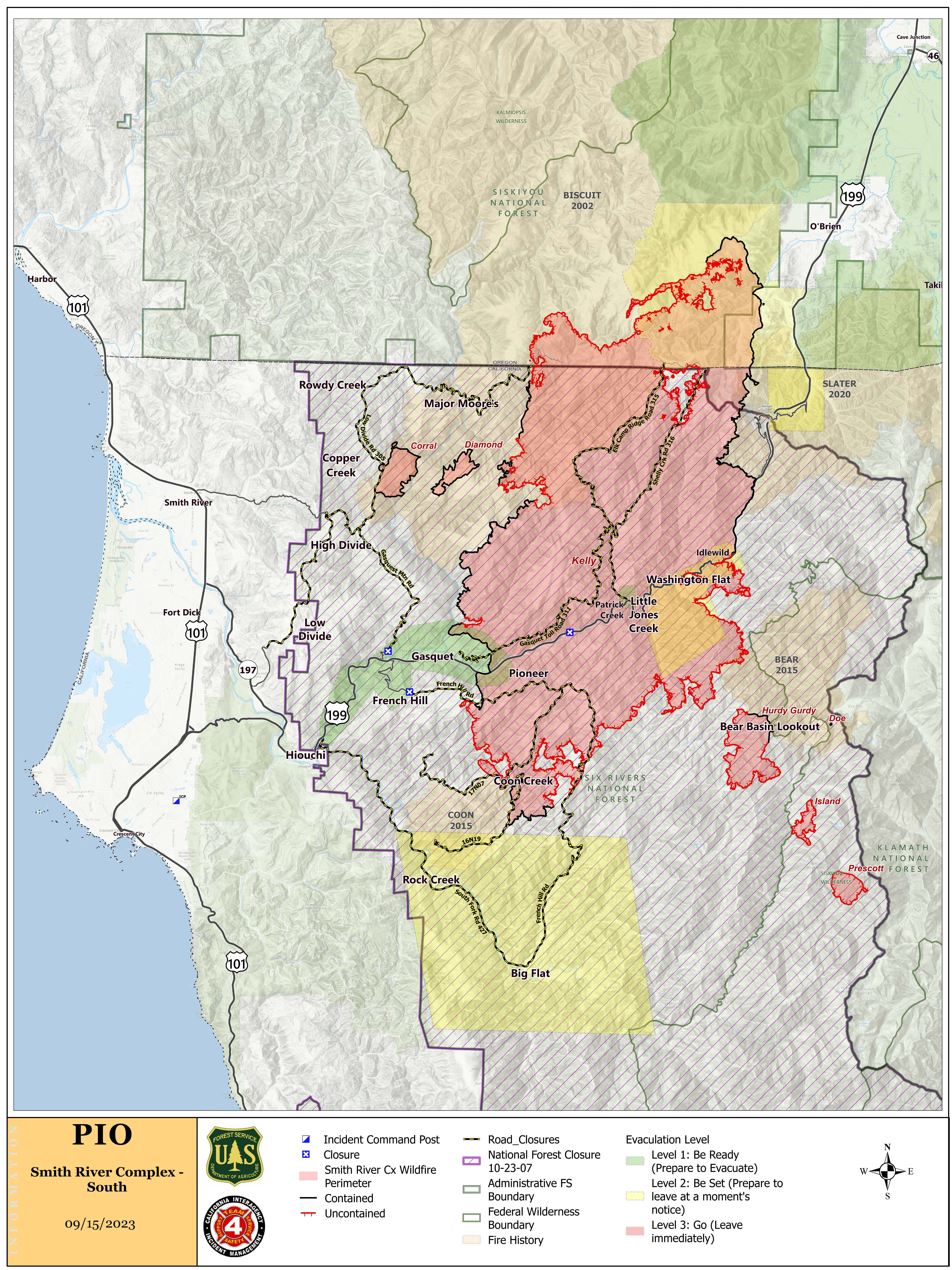
SMITH RIVER COMPLEX—SOUTH Incident Update
Date: 9/15/23
Location: Six Rivers National Forest
Size: acres 88,970
Percent Contained: 38%
Cause: Lightning
Start Date: Tuesday, August 15, 2023, 6:01 PM
Vegetation: Timber (Litter and Understory) and Brush
Number of Personnel Assigned: 1,601
CURRENT SITUATION: Yesterday was the hottest, driest day in several weeks, the fire was not as active as expected but did grow due to light winds and a smoke inversion. Along US 199, firefighters continued to extinguish hotspots and secure the recent firing operation. In Stoney Creek, north of Gasquet, crews and helicopters continued to suppress areas of heat to prevent the fire from progressing west. On the fire’s east side near Washington Flat and Little Jones Creek, activity was mainly smoldering and creeping within the perimeter. Crews completed a shaded fuel break near Table Mountain that will serve as a secondary fireline. A shaded fuel break is where firefighters thin out trees and vegetation in areas to help control spread of wildfire. Near the southwestern area of the fire, crews continue a strategic firing operation around Coon Creek and continue to monitor and mop up areas of heat. The Hurdy Gurdy Fire was active on its eastern side, and crews are scouting for opportunities to keep it from spreading eastward and mopping up the southern perimeter. On the western side of the fire, crews will continue to patrol and mop up.
With the good weather, crews are planning small burning operations through the weekend. Work priorities for today are along US 199, Stoney Creek, and southeast side where the crews will attempt to use direct suppression tactics.
WEATHER: Conditions in the fire area remained dry throughout Thursday night. Hot and dry daytime conditions are expected to remain through Saturday. The smoke inversion is expected to lift by noon Friday, potentially creating favorable conditions for firefighters to continue planned firing operations.
EVACUATIONS: Some Del Norte County evacuation zones remain under either a Level 2 (Get Set) or Level 1 (Get Ready) evacuation order. View the interactive evacuation map online: tinyurl.com/29vv2wpm..
AIR QUALITY: Smoke Outlooks with air quality and forecast information are available here: tinyurl.com/258mfms3.
CLOSURES: US 199 in Del Norte County will be fully closed twice daily, Monday through Friday, from 8 AM to 11 AM and from 1 PM. to 4 PM. During all open hours, traffic will be one-way and piloted between Madrona and Oregon Mountain Road. Motorists should anticipate delays during all open hours. Caltrans provides information on current highway conditions online (roads.dot.ca.gov), by phone (800-427-7623), and on Facebook (facebook.com/CaltransD1).
Six Rivers National Forest lands, roads, trails, and recreation sites in the vicinity of the complex are closed (Forest Order No. 10-23-06). View the Order and closure map on the Forest’s website: tinyurl.com/4atens8c.
Fire Information: 707-383-9727
Hours: 8 a.m. to 8 p.m.
Email: 2023.SmithRiverComplex@firenet.gov
facebook.com/SixRiversNF
youtube.com/@smithrivercomplex-srf
Incident Website: inciweb.nwcg.gov/incident-information/casrf-smith-river-complex-
Prescribed Fire Planned September 17 and 18 2023
Related Incident: Lolo National Forest Prescribed Fire Operations
Publication Type: Announcement
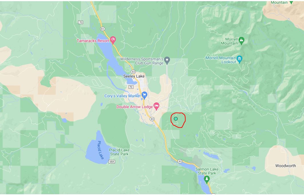
Seeley Ranger District: Pending conditions, prescribed fire operations will take place today and tomorrow on the Seeley Ranger District to help reduce hazardous fuels, restore wildlife habitat, and create better protection around communities from future wildfires. The 261-acre prescribed fire operation is located approximately 2 miles southeast of the community of Seeley Lake; east of Highway 83 between mile markers 10 and 13. Smoke may be visible from Seeley for the duration of the burn. Firefighters and engines will implement the prescribed burn, patrol, and monitor the burning over the next few days.
Tyee Ridge Complex BLM Closure Order
Related Incident: Tyee Ridge Complex
Publication Type: Closures
Update Brice Creek Dinner and Grizzly Fires September 15 2023
Related Incident: Brice Creek FireDinner FireGrizzly Fire
Publication Type: News
A strong warming and drying trend will impact the fire area Friday bringing above normal temperatures and lower humidities. In the late afternoon, when humidity is at its lowest, an increase in fire behavior is possible during this time, especially on southern facing slopes. Firefighters on the ground, supported by aircraft will continue suppression, and patrol across all three fires as well as at Chilcoot and Ridge Fires.
Brice Creek Fire: Size: 588 acres | Start Date: August 24, 2023 | Cause: Lightning | Containment: 55%
Yesterday, helicopters made water drops in the southwest area as unburned patches flared up due to the warmer and drier weather. Firefighters hiked south of Road 709 to the fires edge, mopping up to help maintain a secure edge. Today, firefighters will continue to hold, secure, mop up control lines, and work on contingency lines. Helicopter bucket work is anticipated in the northeast corner where there was moderate fire activity yesterday. Smoke will continue to show within the fire perimeter.
Dinner Fire: Size: 304 acres | Start Date: August 24, 2023 | Cause: Lightning | Containment: 95%
Firefighters will walk control lines today looking for and mitigating any lingering hot spots, hazards or smokes to validate the viability of control features as the Dinner Fire moves towards patrol status and full containment.
Grizzly Fire: Size: 111 acres | Start Date: August 24, 2023 | Cause: Lightning | Containment: 0%
Yesterday, two scoopers and two helicopters continued to make numerous trips along the southern and southwestern flank of the fire preventing the spread toward Champion Creek. The advantages of using a scooper with its 1300 to 1800 gallons of water, speed of the delivery in this very steep terrain is its ability to have the water payload break through the canopy, penetrate the duff layer and reach the ground, limiting fire growth. Scoopers and helicopters are scheduled for today to assist in the hotter and dryer weather. Structural protection resources continue to patrol in the area.
Weather: Friday will be unseasonably warm and dry with temperatures in the 80’s to mid-90’s and humidity dropping to 19 %. Winds will be light from the east in the morning shifting to northwest in the afternoon.
Evacuations: Lane County issued a Level 2 Evacuation (Be Set) for all private lands and mining claims in the Bohemia areas within the Cottage Grove Ranger District of the Umpqua National Forest.
Safety and Closures: Please remember to stay out the fire area this includes flying any unmanned aircraft (drones), if you fly we cant. There is a forest closure for portions of the Umpqua National Forest in response to fire activity in the area to protect public and wildland firefighter safety. There is a Temporary Flight Restriction over the fire area.
--
Facebook: https://www.facebook.com/bricecreekdinnergrizzlyfires2023/
Fire Information: (541) 900-5862, 8:00 AM – 7:00 PM
Email: 2023.dinner@firenet.gov
Anvil and Flat Fire Community Meeting Sept 15
Related Incident: Anvil FireFlat Fire
Publication Type: Announcement
A community meeting will be held for the Anvil Fire on Friday, September 15 at 7:00 p.m. at The Grange (44556 Highway 101) in Sixes. If internet connection allows, the meeting will be broadcast on Facebook Live. Otherwise, it will be recorded and posted to Facebook afterwards.