
FOREST CLOSURE UPDATE EFFECTIVE SEPTEMBER 16 2023
Related Incident: Smith River Complex
Publication Type: Closures
FOREST CLOSURE UPDATE - EFFECTIVE SEPTEMBER 16, 2023
Six Rivers National Forest Reduces Forest Closure Order for the Smith River South and South Fork Complexes.
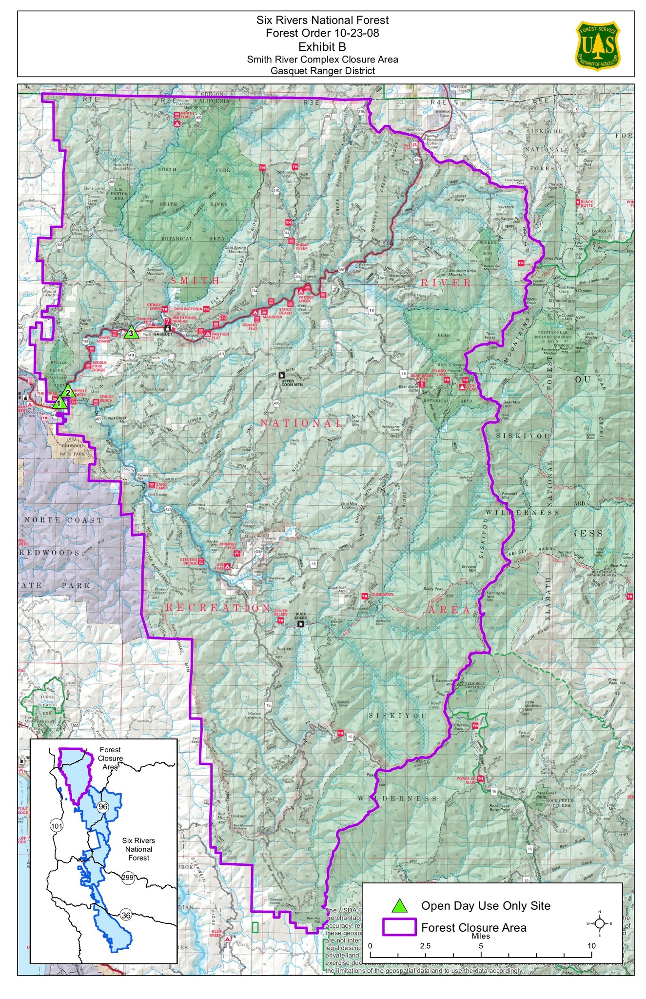
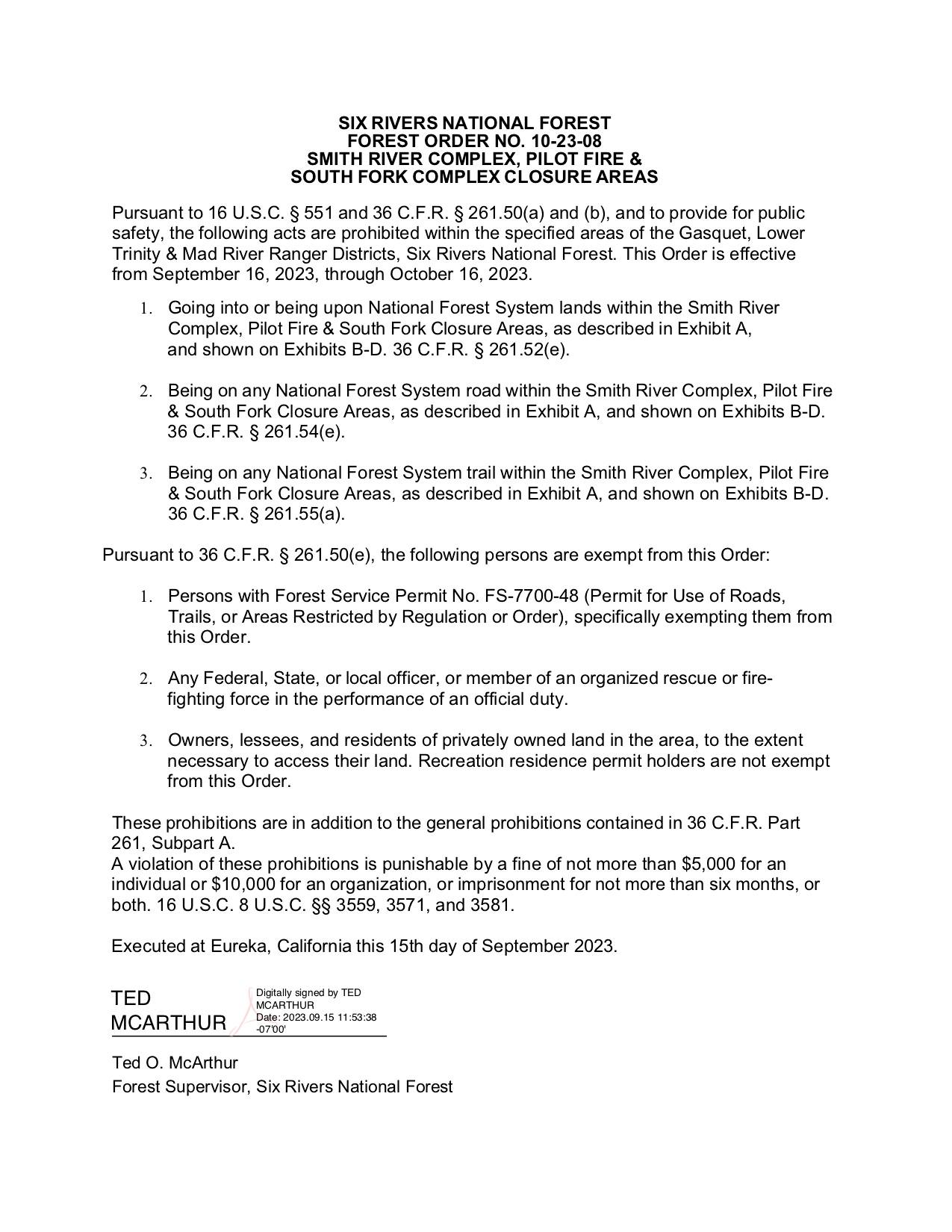
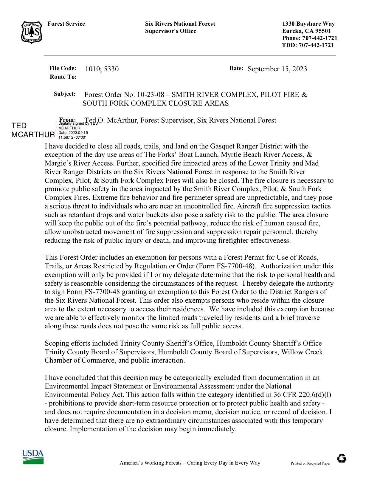
The Six Rivers National Forest is reducing the forest closure order for the Gasquet, Lower Trinity, and Mad River Ranger Districts. The decision to reevaluate the closure order was made after close coordination between the incident management teams for the Smith River South and South Fork Complexes and the Six Rivers National Forest. The forest closure order for the SRF Lightning Complex remains unchanged at this time.
The purpose of the forest closure order is to provide for public safety in response to the ongoing wildfire activity within each complex. The forest closure order temporarily restricts access to any National Forest System road, trail, or land within the closure area.
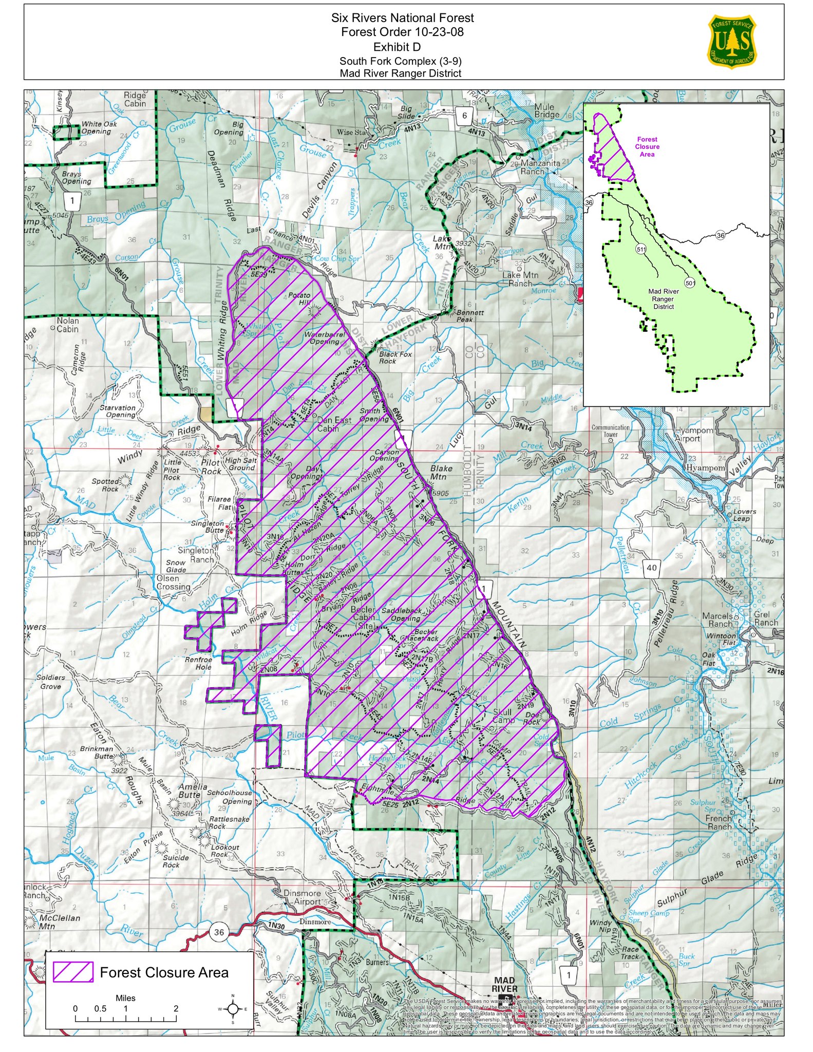
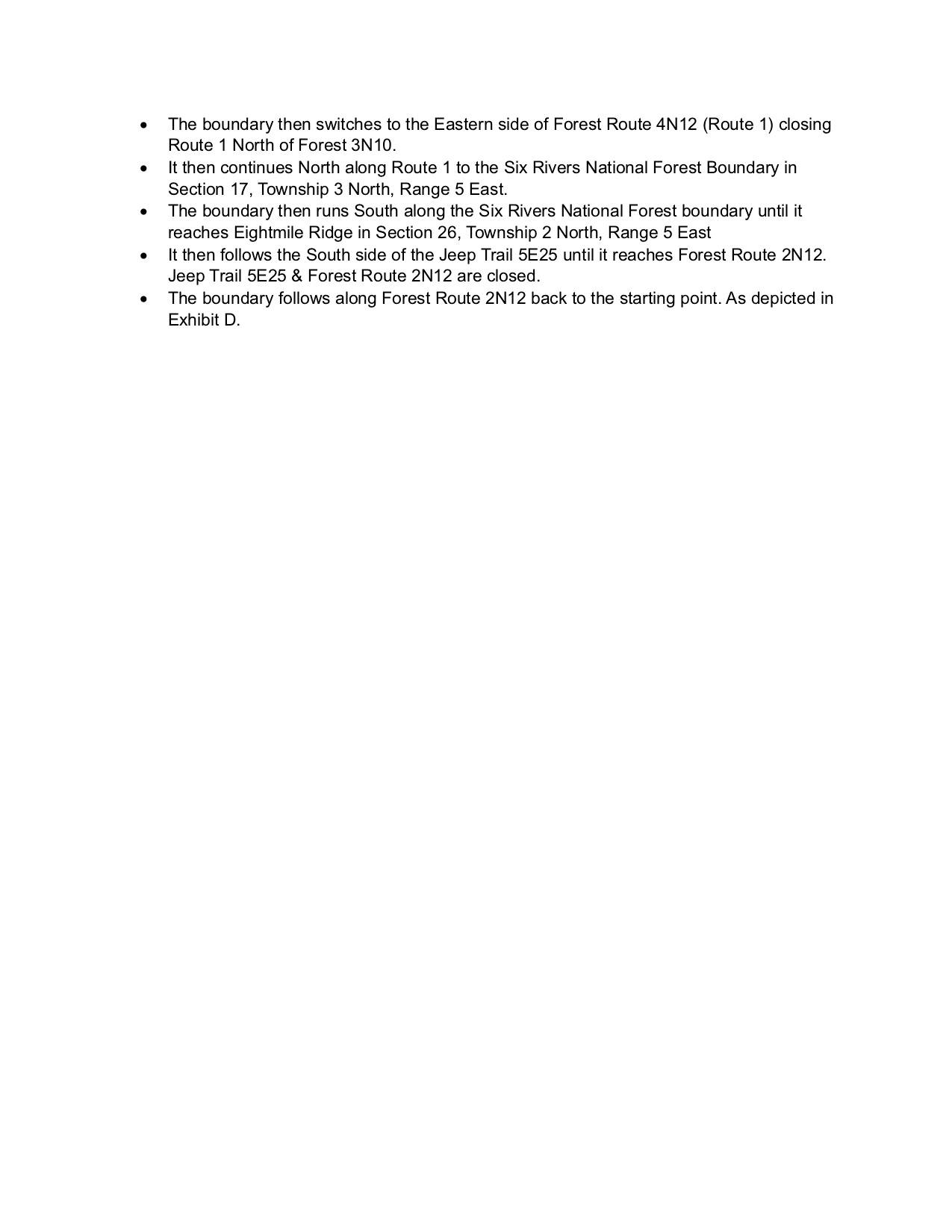
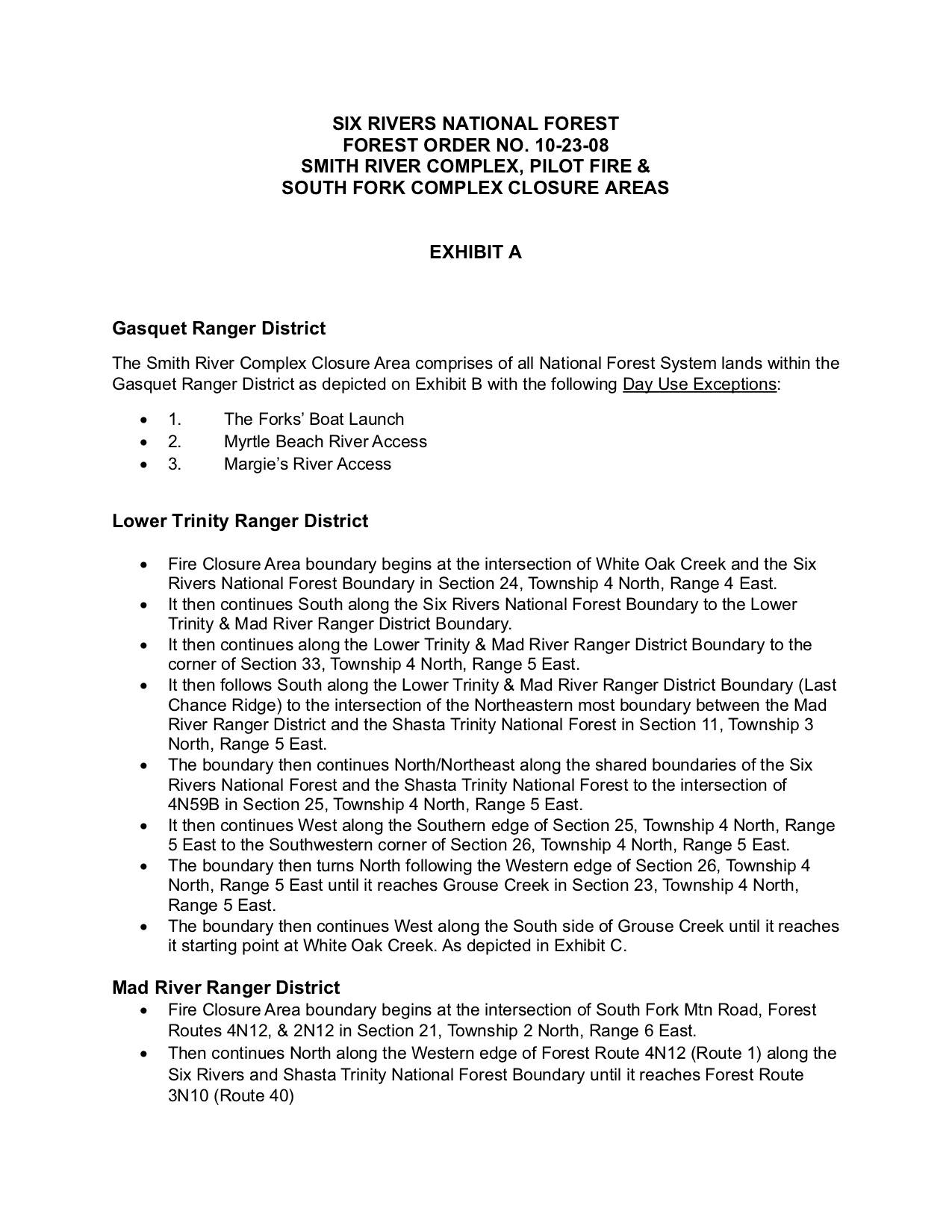
The new closure area for the South Fork Complex includes the southwestern portion of the Lower Trinity Ranger District and the northern portion of the Mad River Ranger District along Route 1, as depicted in Forest Order 10-23-08, Exhibits C and D.
The Mad River Ranger District office will remain open this weekend, Saturday 16th and Sunday 17th, from 8:00 am to 4:30pm, closed for lunch at noon. Visitors will be able to obtain updated fire information, purchase firewood permits, and get deer tags validated.
You can find the the updated forest closure order, area description, and map in the photos below.
Fire information for the complexes can be found at the following links:
South Fork Complex: https://inciweb.nwcg.gov/inciden.../cashf-south-fork-complex
Smith River Complex: https://inciweb.nwcg.gov/incide.../casrf-smith-river-complex
#SouthForkComplex #SixRiversNational #MadRiver
Smith River Complex North Saturday September 16 2023
Related Incident: Smith River Complex
Publication Type: News
Smith River Complex North
Update for Saturday, September 16, 2023
Size: 90,294 total/ 12,342 in Oregon
Start Date: August 15, 2023
Location: Grants Pass, OR
Containment: 51%
Total personnel: 1,677 for Complex
Cause: Lightning
Resources: 45 crews 11 helicopters 65 engines 11 bulldozers 25 water tenders 14 masticators 1 Skid Steer
Yesterday: Helitack modules have been spiked out on the northwestern edge of the fire to hold the perimeter during critical fire weather days. Crews on the northern edge of the fire turned their focus to mop up as well as adding depth to control line with interior firing. Oregon Department of Environmental Quality issued a smoke advisory yesterday morning for Curry and Josephine counties that is in effect through Sunday night.
Today’s Activities: The smoke layer and return to northwesterly winds will moderate fire behavior over the next few days. As the weather moderates, crews on the northern edge of the fire will continue to mop up and burnout interior pockets of vegetation. On the northwest edge of the fire perimeter, crews will monitor conditions and continue to work toward containment with air support as visibility permits. On the eastern edge of the fire, crews will start removing structure protection (pumps, hoses, and sprinklers) from some properties in evacuation zones.
Smoke: An air quality advisory is in effect for Curry and Josephine counties through Sunday evening, September 17 due to smoke from the Anvil and Smith River Complex fires. VERY UNHEALTHY to HAZARDOUS smoke impacts will persist most of the day with the potential for some improvement this evening. Smoke levels can change rapidly depending on weather; check current conditions at: https://bit.ly/SWORsmoke
Closures: The Rogue River-Siskiyou National Forest issued an area and road closure for a 400-yard-wide corridor centered on Forest Road 1106 (South Elk Mountain Road), Forest Road 1205 (Lower Wheeler Road), and Forest Road 1983 (Mt. Emily Road) beginning yesterday, September 14 through October 31, 2023. The closure allows for safe operations related to the Smith River Complex North. Closures on BLM land are in place, as well. Visit bit.ly/RRSNFAlerts or https://www.blm.gov/orwafire for additional information.
Road Closures and Delays: Starting Thursday, September 14, Caltrans in Del Norte County issued a schedule of road closures and lane restrictions on US-199. Weekdays will have a combination of road closure and lane restrictions. Over the weekend, the road will remain open, but with lane restrictions and pilot cars. Expect delays. For specific information on road access, please see the Caltrans QuickMap site https://quickmap.dot.ca.gov/ and Oregon Department of Transportation’s https://www.tripcheck.com/. Local law enforcement cautions against any non-essential traffic along this route. Navigation apps and mapping programs have been routing travelers into active fire areas. Do not use forest roads as alternate routes.
Evacuations: The area east of US-199 from mile post 39 to the Oregon/California border in southwest Josephine County is at Level 1-BE READY; west of US-199 remains in Level 2-GET SET until fire conditions and hazards are further mitigated. Monitor the Rogue Valley Emergency Management site and sign up for evacuation alerts and updates at https://rvem.org/. An interactive Fire First Response Map with evacuation areas can also be found there.
Restrictions: Please respect the temporary flight restriction (TFR) established for the Smith River Complex. Keep drones away from firefighting operations and the TFR. If you fly, we can’t. Don’t be the reason a firefighting air mission has to divert! For more information on the TFR, visit https://tfr.faa.gov/.
Fire Update September 16th
Related Incident: Bear Creek Fire
Publication Type: News
BEAR CREEK FIRE
September 16, 2023
Type 3 Team, Incident Commander: Nathan Hallam
Daily Update – 9:00 AM
This update will continue to occur every other day unless significant activity occurs.
Highlights: Yesterday, both the Bear Creek and Quartz Ridge Fire received scattered thunderstorms producing light
rain and wind gusts up to 15+ mph throughout the day. Relative humidity levels stayed above 75%. Both fires saw
little fire activity. Light smoke was observed on both the Bear Creek and Quartz Ridge Fire. With the return of clear
skies and dry weather fire activity is expected to increase slightly allowing for additional smoke production.
Bear Creek Fire: 1090 acres | 83% of objectives achieved | 22 personnel assigned
Weather conditions have slowed fire activity, allowing firefighting crews to place focus on mitigating hazards to the
values at risk within the Weminuche Valley. Road conditions have deteriorated due to the rain make access to the
fire difficult. Slowing fire activity and minimal smoke was observed by crews working in the area. Rainfall totals
measured a total of 0.27’’ over the past 24 hours.
Weather: Today’s weather outlook calls for early morning cloud dispersion, giving way to a day filled with clear,
sunny skies with temperatures reaching into the low to mid 60’s. Cooler temperatures and clear skies with winds
gusts of 5-10mph can be expected through Sunday.
San Juan National Forest Temporary Closures: Closure orders are in effect and additional information can be found
here: Quartz Ridge Closure and Bear Creek Closure. Roads and trails within the Quartz Fire area are Quartz Meadows
Rd (NFSR#684), Quartz Ridge Trail (NFST#570), Quartz Creek Trail (NFST#571). The trails within the Bear Creek Fire
area are Little Sand Trail (NFST #591) and Shaw Creek Trail (NFST#584).
Fire Update September 16th
Related Incident: Quartz Ridge Fire
Publication Type: News
QUARTZ RIDGE FIRE
September 16, 2023 Type 3 Team, Incident Commander: Nathan Hallam
Daily Update – 9:00 AM
This update will continue to occur every other day unless significant activity occurs.
Highlights: Yesterday, both the Bear Creek and Quartz Ridge Fire received scattered thunderstorms producing light
rain and wind gusts up to 15+ mph throughout the day. Relative humidity levels stayed above 75%. Both fires saw
little fire activity. Light smoke was observed on both the Bear Creek and Quartz Ridge Fire. With the return of clear
skies and dry weather fire activity is expected to increase slightly allowing for additional smoke production.
Quartz Ridge Fire: 2,848 acres | 77% of objectives achieved | 59 personnel assigned
The increase in acreage was the result of the last active day (9/10), prior to the rain event. Firefighting crews
continue to focus on improving the shaded fuel break lines on the East Fork Road. Continual improvement of the
firebreak lines will be priority for Quartz Ridge fire crews with anticipation of the project continuing along the 684
road into the next two operational shifts. Rainfall totals for the last 24 hours measured 0.16’’.
Weather: Today’s weather outlook calls for early morning cloud dispersion, giving way to a day filled with clear,
sunny skies with temperatures reaching into the low to mid 60’s. Cooler temperatures and clear skies with winds
gusts of 5-10mph can be expected through Sunday.
San Juan National Forest Temporary Closures: Closure orders are in effect and additional information can be found
here: Quartz Ridge Closure and Bear Creek Closure. Roads and trails within the Quartz Fire area are Quartz Meadows
Rd (NFSR#684), Quartz Ridge Trail (NFST#570), Quartz Creek Trail (NFST#571). The trails within the Bear Creek Fire
area are Little Sand Trail (NFST #591) and Shaw Creek Trail (NFST#584).
Cowlitz Complex Daily Update September 16 2023
Related Incident: Cowlitz Complex
Publication Type: News
Cowlitz Complex Fire Update
September 16, 2023
Current Situation: The Cowlitz Complex is 32% contained with a total of 684 acres and 377 personnel. Aircraft continued to drop water over the Grassy Mountain, Snagtooth, and Spencer Quartz fires on Friday. Crews are making progress on indirect containment lines on these fires to keep them within their current perimeter. Warmer and drier temperatures are expected to last through today, Saturday, September 16. Current fire activity is not anticipated to threaten the nearest communities of Randle or Packwood, Washington.
Firewise Training: There will be a free Firewise training this morning, September 16 from 10 am to 12 pm at the Packwood Main Fire Station on State Highway 12.The public is encouraged to attend.
Background: There are 30 fires in the complex. The fires started August 25 after a lightning event across the Gifford Pinchot National Forest. Maintaining the level of firefighting resources, dedication to safety, and keeping fires in their current footprint remain priorities, as well as continuing to be ready for any new fire starts or spread. All fires are being managed under full suppression strategy.
Fire Restrictions: Fire Restrictions remain in effect. Campfires are prohibited across the Gifford Pinchot National Forest – only propane-fueled fire pits, stoves and lanterns are allowed. Additional information is available on the forest’s website at Gifford Pinchot National Forest - Fire Management (usda.gov). The decision to lift or maintain fire restrictions depends on factors such as current and expected weather conditions, fuel moisture, the level of fire activity, and the availability of firefighting resources to respond to additional ignitions.
Closures: In anticipation of ongoing fire activity in the vicinity of the Snagtooth Fire the following roads and trails are closed to the public to reduce exposure and help ensure public and firefighter safety: Forest Roads 9300 and 9341, Boundary Trail #1 (from Elk Pass to intersection with Summit Prairie), Summit Prairie #2, Craggy Peak #3, Snagtooth #4, Quartz #5, Stabler Camp #17, Wright Meadows #80, Basin Camp #3A, Quartz #5B, Quartz #5C (French Creek), Snyder Pasture #80A. Forest Road 8410 is closed for firefighter and public safety in the vicinity of the Pothole Fire, and Forest Road 78 is temporarily closed between the 78 and the 22 junction due to hazardous debris rolling out onto the roadway.
Temporary Flight Restrictions: Two TFRs are in effect, one located north of US-12 to Mount Rainier National Park, and a new TFR south of US-12 to include Snagtooth and Spencer Quartz fires. Fire aviation response is halted or delayed if an unauthorized aircraft enters the TFR. Temporary flight restrictions also apply to unmanned aircraft systems or drones. Learn more: Know Before You Fly.
Anvil and Flat Fire Update Sept 16
Related Incident: Flat Fire
Publication Type: News
Anvil Fire
Size: 6,650 acres
Start Date: August 25, 2023
Location: 8 miles east of Port Orford, OR
Containment: 0%
Total personnel: 341
Resources: 9 crews, 4 helicopters, 10 engines
After low visibility kept Anvil Fire aerial resources grounded yesterday morning, helicopters dropped 62,000 gallons of water on the fire throughout the afternoon. An Unmanned Aerial System (drone) was utilized to look for any hot spots or areas where small fires may have started outside of the perimeter.
The Elk River drainage remains a high priority with resources focusing on structure protection along Elk River and McGribble Roads, creating direct containment lines in areas where firefighters have safe access and a high probability of success. Crews also continue to improve existing roads and natural features to use as containment lines. Additional resources were moved to the southern side of the fire to identify opportunities where crews can safely engage the fire directly. Great Basin Team 4, local fire authorities, and cooperators have plans in place in the event the fire moves towards residences.
Smoke impacts will likely limit aerial resources today until later in the afternoon when visibility is forecast to improve.
Evacuations: A Level 3 “Go“ evacuation status is in place along Elk River Road from milepost 4 to the Butler Bar Campground. There are Level 2 “Get Set“ evacuations in place from the intersection of U.S. Highway 101 and Elk River Road to milepost 4 on Elk River Road as well as along Sixes River Road from Edson Creek Campground to Sixes River Campground, about 16 miles east of U.S. Highway 101. An interactive evacuation map is available from the Curry County Sheriff’s Office at https://bit.ly/45UIh2E. Sign up for Curry Co. emergency alerts at https://bit.ly/CurryCoEM.
Flat Fire
Size: 34,242 acres
Start Date: July 15, 2023
Location: 2 miles southeast of Agness, OR
Containment: 75%
Total personnel: 212
Resources: 1 crew, 3 helicopters, 7 engines
The Flat Fire continues to have widely scattered interior smoldering, however no perimeter growth is expected. Heavy equipment and hand crews completed the majority of suppression repair on firelines that were created as contingency containment lines. Additional work is expected to be completed over the next week. Although some smoke may be visible, it is generally from internal pockets of unburned vegetation. Fire managers will continue to monitor this activity and respond as appropriate to prevent additional fire spread while also ensuring firefighter safety.
Evacuations: A Level 1 “Get Ready” evacuation status is in place for areas near the Flat Fire.
General Information
Weather: Overnight, light east winds were observed with a distinct moisture and temperature gradient based on elevation. Very warm and critically dry conditions continue over the area today. Slightly cooler temperatures and higher relative humidity are expected this weekend with mostly light east winds at night and northwest ridgetop winds during the day.
Smoke: Visit https://bit.ly/SWORsmoke for current smoke and air quality updates.
Area and Road Closures: The Rogue River-Siskiyou National Forest has issued a closure order for the Anvil Fire. Visit https://bit.ly/RRSNFAlerts for closure maps and information. The Bureau of Land Management’s Edson and Sixes Campgrounds are closed until further notice. Please drive slowly and with headlights on through any fire area, especially when smoke limits visibility. Heavy equipment and firefighter transportation vehicles are using the area highways and roads as well. Caltrans issued a schedule of road closures and lane restrictions on US-199. Local law enforcement cautions against any non-essential traffic along this route. For specific information on road access, please see the Caltrans QuickMap site at: https://quickmap.dot.ca.gov/ and Oregon Department of Transportation site at: https://www.tripcheck.com/. Do not use forest roads for alternate routes.
Restrictions: The RRSNF fire danger is high and the Industrial Fire Precaution is at Level 2. Public Use Restrictions remain at Stage 3 across the forest and on the Wild Section of the Rogue National Wild and Scenic River. There is a Temporary Flight Restriction over the fire areas. Please do not fly unmanned aircraft (drones) in the fire vicinity.
Anvil and Flat Fire Update Sept 16
Related Incident: Anvil Fire
Publication Type: News
Anvil Fire
Size: 6,650 acres
Start Date: August 25, 2023
Location: 8 miles east of Port Orford, OR
Containment: 0%
Total personnel: 341
Resources: 9 crews, 4 helicopters, 10 engines
After low visibility kept Anvil Fire aerial resources grounded yesterday morning, helicopters dropped 62,000 gallons of water on the fire throughout the afternoon. An Unmanned Aerial System (drone) was utilized to look for any hot spots or areas where small fires may have started outside of the perimeter.
The Elk River drainage remains a high priority with resources focusing on structure protection along Elk River and McGribble Roads, creating direct containment lines in areas where firefighters have safe access and a high probability of success. Crews also continue to improve existing roads and natural features to use as containment lines. Additional resources were moved to the southern side of the fire to identify opportunities where crews can safely engage the fire directly. Great Basin Team 4, local fire authorities, and cooperators have plans in place in the event the fire moves towards residences.
Smoke impacts will likely limit aerial resources today until later in the afternoon when visibility is forecast to improve.
Evacuations: A Level 3 “Go“ evacuation status is in place along Elk River Road from milepost 4 to the Butler Bar Campground. There are Level 2 “Get Set“ evacuations in place from the intersection of U.S. Highway 101 and Elk River Road to milepost 4 on Elk River Road as well as along Sixes River Road from Edson Creek Campground to Sixes River Campground, about 16 miles east of U.S. Highway 101. An interactive evacuation map is available from the Curry County Sheriff’s Office at https://bit.ly/45UIh2E. Sign up for Curry Co. emergency alerts at https://bit.ly/CurryCoEM.
Flat Fire
Size: 34,242 acres
Start Date: July 15, 2023
Location: 2 miles southeast of Agness, OR
Containment: 75%
Total personnel: 212
Resources: 1 crew, 3 helicopters, 7 engines
The Flat Fire continues to have widely scattered interior smoldering, however no perimeter growth is expected. Heavy equipment and hand crews completed the majority of suppression repair on firelines that were created as contingency containment lines. Additional work is expected to be completed over the next week. Although some smoke may be visible, it is generally from internal pockets of unburned vegetation. Fire managers will continue to monitor this activity and respond as appropriate to prevent additional fire spread while also ensuring firefighter safety.
Evacuations: A Level 1 “Get Ready” evacuation status is in place for areas near the Flat Fire.
General Information
Weather: Overnight, light east winds were observed with a distinct moisture and temperature gradient based on elevation. Very warm and critically dry conditions continue over the area today. Slightly cooler temperatures and higher relative humidity are expected this weekend with mostly light east winds at night and northwest ridgetop winds during the day.
Smoke: Visit https://bit.ly/SWORsmoke for current smoke and air quality updates.
Area and Road Closures: The Rogue River-Siskiyou National Forest has issued a closure order for the Anvil Fire. Visit https://bit.ly/RRSNFAlerts for closure maps and information. The Bureau of Land Management’s Edson and Sixes Campgrounds are closed until further notice. Please drive slowly and with headlights on through any fire area, especially when smoke limits visibility. Heavy equipment and firefighter transportation vehicles are using the area highways and roads as well. Caltrans issued a schedule of road closures and lane restrictions on US-199. Local law enforcement cautions against any non-essential traffic along this route. For specific information on road access, please see the Caltrans QuickMap site at: https://quickmap.dot.ca.gov/ and Oregon Department of Transportation site at: https://www.tripcheck.com/. Do not use forest roads for alternate routes.
Restrictions: The RRSNF fire danger is high and the Industrial Fire Precaution is at Level 2. Public Use Restrictions remain at Stage 3 across the forest and on the Wild Section of the Rogue National Wild and Scenic River. There is a Temporary Flight Restriction over the fire areas. Please do not fly unmanned aircraft (drones) in the fire vicinity.
Lookout Bedrock Horse Creek Pothole Fires Daily Update 9162023
Related Incident: Lookout FireBedrock Fire2023 Horse Creek Fire
Publication Type: News
Lookout/Horse Creek/Pothole/Bedrock Fires
September 16, 2023 - Morning Fire Update
Lookout: Total Personnel: 756 | Size: 24,692 acres l Start Date: August 5, 2023 l Cause: Lightning l Containment: 50%
Resources: 25 engines l 13 crews l 4 bulldozers l 24 water tenders l 7 masticators l 4 helicopters l 2 skidders
Fire activity increased Friday with temperatures in the low 90s and lower humidities. As a result, there was more smoke in the area until the inversion lifted in the early afternoon. Today’s forecast of hot and dry weather will again result in increased fire behavior. Firefighters are holding the containment lines. Alternate containment lines are being prepped along the northwestern edge of the fire, and small-scale burnout operations are being conducted to remove fuels between roads and the main fire. Containment lines to the north are being improved. Air operations will be active in supporting firefighters on the ground with water drops. Air resources assisted on Pete’s Lake Fire in an effort to slow down the fire’s progression in the Three Sisters Wilderness.
Horse Creek: Total Personnel: 60 |Size: 763 acres l Start Date: August 24, 2023 l Cause: Lightning l Containment: 96%
Resources: 4 engines l 1 crew l 1 bulldozer l 2 water tenders l 2 fellerbunchers l 1 excavator | 1 skidder
Firefighters are holding and securing containment lines on the west, north and south sides of the fire. Pockets of heat in the interior portions of the fire are being monitored by engines and crews who are patrolling the fire area. Resources have shifted to more suppression repair activities.
Pothole: Total Personnel: 16 |Size: 109 acres l Start Date: August 25, 2023 l Cause: Lightning l Containment: 90% Resources: 1 engine l 1 water tender | 1 excavator
Pothole Fire is in a similar status as Horse Creek with ongoing patrolling and monitoring of containment lines. Crews are continuing chipping operations, and will begin the process of removing woody material from roadsides and fire lines.
Bedrock: Total Personnel: 116 | Size: 31,590 acres l Start Date: July 22, 2023 l Cause: under investigation l Containment: 97%
Resources: 5 engines l 3 crews l 3 water tenders l 3 masticators l 4 excavator l 1 skidder
On the Bedrock Fire, fires continue to burn slowly in the interior portions of the fire that remain inaccessible due to steep terrain. Patrols looking for smoke or heat continue on the northside. On the southside, firefighters spent the shift patrolling and mopping up to ensure no heat exists along the containment line, and mitigating hazards so that repair work can be done safely. Dozer line repair work is also underway.
Yesterday, an inversion layer broke later in the day than expected and contributed to smoke in the area until mid-afternoon. Today will be the last very hot and dry day with light terrain driven winds. As a result, like yesterday, increased fire behavior and smoke are forecast. Smoke from not only the Lookout Fire, but also other fires, such as Pete’s Lake and the Smith’s River Complex in northern California are contributing the smoke in the area.
Evacuation Update
Linn County Evacuations: For the Lookout Fire, a Level 1 (Be Ready) evacuation notice is in place. For more information visit the Linn County Sheriff’s Office for a map and updated information: https://www.linnsheriff.org/wildfire_live_updates.
Lane County Evacuations: There are no evacuation notices on the Bedrock Fire. However, on the Lookout Fire, Horse Creek Road east of the Horse Creek Bridge remains in Level 2 (Be Set) evacuation notice. Specific guidance on evacuation level locations around the Lookout Fire can be found at www.LaneCountyOR.gov/LookoutFire.
Forest Closures: The closure order for the Lookout Fire was reduced on September 7. Updated closures can be found at: https://www.fs.usda.gov/alerts/willamette/alerts-notices/?aid=61574. Hunting season is here, please be aware of these closures. Closures are initiated to keep the public and firefighters safe while hazards are mitigated. For more information on hunting, contact the Oregon Department of Fish and Wildlife @ (503)947-6000 or https://myodfw.com
Restrictions: Fire Restrictions are in place on the Willamette National Forest. Visit the Willamette National Forest Website to view current forest closures. Temporary Flight Restrictions remain in place over the Bedrock and Lookout Fire areas.
Smoke Outlook: https://outlooks.wildlandfiresmoke.net/outlook/4c92bc1a The Fire and Smoke Map (fire.airnow.gov) is another source for air quality information.
Lookout Information Line: 541-215-6735 (8 a.m. - 8 p.m.)
Email: 2023.lookout@firenet.gov
Facebook: https://www.facebook.com/LookoutFire2023
Inciweb: https://inciweb.nwcg.gov/incident-information/orwif-lookout-fire
Bedrock Fire Information: 541-414-6272 (8 a.m. - 8 p.m.)
Email: 2023.bedrock@firenet.gov
Facebook: https://www.facebook.com/BedrockFire2023/
Inciweb: https://inciweb.wildfire.gov/incident-information/orwif-bedrock-fire
Saturday September 16 2023 Valentine fire update and map
Related Incident:
Publication Type: News
Size: 2,881 acres
Start Date: August 16, 2023
Cause: Lightning
Completion: 49%
Total personnel: 177
Location: 11 miles northeast of Young, Arizona and 27 miles
east of Payson, Arizona
Fuels: Ponderosa Pine, Hardwood litter and timber
Highlights: Conditions begin to show a drying trend through the weekend, allowing crews to test consumption of fuels and begin looking for opportunities to continue hand and aerial ignitions.
Operations: Friday, crews on the western border of the fire went in to test consumption of fuels with hand ignition. Some of the ridges showed to be drier than some of the drainages. Crews on the southeast corner scouted the area to familiarize and check for evenness of fire progression along the 411 road. Today, crews will continue to test consumption of fuels and look for good opportunities to tie in aerial ignitions on some of the ridges to the west.
Fire Ecology: Plants and plant communities develop adaptations to specific ecological conditions. In areas with historically short fire return intervals (high fire frequency) plants have adapted not only to survive fire but to take advantage of fire, and they do better when there are frequent fires. The kind of fire (frequency, severity) that a plant can survive varies widely based on the species, and depending on the types of adaptations they have developed. For example, mature ponderosa has thick bark (insulation), grows tall (keeps the growing tips of the branches out of the fire) and naturally drops its lower branches (self-pruning).
Weather: Friday was fairly dry as most of the thunderstorms remained to the north and did not pass over the fire area. Today will be similar with a better chance of warming up, staying dry, and a slight drop in humidity. Going into Sunday we may see an increased chance of afternoon showers.
Closures: An emergency closure order for the Valentine Fire has gone into effect as of 6 a.m. Sept. 5, 2023. The public is asked to avoid the fire area. The purpose of the closure order is to protect public health and safety during the Valentine Fire, and to protect assigned firefighting personnel engaging in wildland firefighting operations. Signs and gates will be in place to remind the public not to enter the fire area. Please visit the Alerts and Notices page for more information. https://www.fs.usda.gov/alerts/tonto/alerts-notices.
Safety: The health and safety of firefighters, and the public are always the highest priority. Members of the public are asked to avoid the fire area.
Smoke: The fire will produce considerable amount of smoke due excessive fuel accumulation. Smoke from the Valentine Fire may be visible in the surrounding areas for many days. Smoke-sensitive individuals and people with respiratory problems or heart disease are encouraged to take precautionary measures an interactive smoke map at https://www.airnow.gov/wildfires/ allows you to zoom into your area to see the latest smoke conditions.
South Fork Complex Update September 16 2023
Related Incident: South Fork Complex
Publication Type: News
South Fork Complex
News - 09/16/2023
Fire Information: 208-510-7856, 8 a.m. to 8 p.m.
Email: 2023.southforkcomplex@firenet.gov
Linktree: https://linktr.ee/2023southforkcomplex
3-9 Fire: 2,840 acres with 85% containment
Pellitreau Fire: 3 acres with 100% containment
Pilot Fire: 1,055 acres with 100% containment
Sulphur Fire: 31 acres with 100% containment
3,929 acres and 90% overall containment for the South Fork Complex
A total of 185 personnel, crews, air support, engines, dozers, and water tenders support the incident.
3-9 Fire – Crews are actively engaged in mop-up and suppression repair while engines are patrolling control lines. Crews are working closely with Resource Advisors from the United States Forest Service to address concerns with tribal, cultural, and natural resources in the area.
The Pilot Fire is 100% contained. Crews will continue to patrol the fire perimeter while actively engaged in suppression repair.
The Pellitreau Fire and the Sulfur Fire are 100% contained. Firefighters continue to patrol the fires periodically to ensure fire remains within containment lines.
Weather: High pressure over the area continues to bring warm and dry weather over the region. Winds started light easterly in the morning, shifting west to northwest mid-afternoon 5 to 10 miles per hour (mph) with gusts between 12 and 16 mph. Temperatures reaching mid to upper 80s. Afternoon humidity levels are dry, dropping into mid-teens to around 20 percent this afternoon.
Forest Closure: Forest Closure orders for the South Fork Complex Fire continue to be in effect and are posted on the Shasta-Trinity National Forest and the Six Rivers National Forest websites. Please avoid closed areas.