
Rail Ridge Daily Update 10 20 2024
Related Incident:
Publication Type: News
Rail Ridge Fire Update
Sunday, October 20, 2024
Central Oregon Wildfire Information: centraloregonfire.org
Email: 2024.railridge@firenet.gov – Phone: 541-208-7111
Social Media, Evacuation and Closure Information: https://linktr.ee/RailRidgeFire
Acres: 176,383 – Containment: 90% – Detection: 09/02/24 – Cause: Lightning – Personnel: 439
Special Notes: Fire area closures are still in effect. For more information on closures as well as Wheeler County and Grant County evacuation information, visit https://linktr.ee/RailRidgeFire. Residents and visitors are reminded that entering a closed area is illegal, and that these closures are in place for public and firefighter safety. Please note that agency officials and fire managers meet daily to assess fire closures and understand the importance of hunting and other recreational activities to the local communities. Thank you for your continued support as we strive toward completing work on this wildfire.
Weather and Fire Behavior: Warmer, drier weather with southwest winds will increase the potential for elevated fire activity during Sunday’s operational period. A cold front will approach from the northwest Sunday, increasing temperatures and generating southwest winds with gusts up 20 mph possible. Maximum temperatures will reach the upper 70s in the valleys and mid to upper 60s on the ridgetops. The front will bring a brief round of showers around daybreak Monday. Primary fire behavior characteristics will likely include smoldering ground fuels and limited surface fire creeping. Heavy fuels such as stump holes and log ends will continue to burn and consume due to long-term seasonal drying. Smoke is still visible in upper Cottonwood Creek as well as A&M Ridge.
Operations Saturday: The primary missions for firefighters included repairing containment lines, backhaul of equipment no longer needed on the fireline, hazard tree removal along Forest Road 2150, road repair, and building an indirect line in the northwest portion of the fire.
Operations Sunday: Resources from the fire will remain ready to respond to any increased fire activity within the fire perimeter or any new start in the area. Much of the repair work along the west, south and east is expected to be completed by the end of shift today. Firefighters will continue preparing the indirect containment line in the northwest corner of the fire. A total of five road groups with graders, rollers and water tenders will repair roads that were impacted by equipment and vehicles during the fire suppression effort.
USFS & BLM Closures / Evacuation Information / Fire Restrictions for the Rail Ridge Fire area can be found at: https://linktr.ee/RailRidgeFire.
Rescinding RailroadDaly Fire AreaRoadTrail Order 10 19 2024
Related Incident:
Publication Type: Closures
RESCINDING ORDER
BEAVERHEAD-DEERLODGE NATIONAL FOREST
Daly Fire Area/Road/Trail
Pursuant to Title 36 Code of Federal Regulation 261.50 (a) & (b), the prohibition listed in Order Number 0102082419, applicable to the Beaverhead Deerlodge National Forest dated October 4, 2024 and signed by Alfred Watson, Forest Supervisor is hereby rescinded effective October 19, 2024 @ 0001. Done at Dillon, MT on 18th day of October 2024.
Alfred Watson
Forest Supervisor
Beaverhead Deerlodge National Forest
Evergreen Forest Fire Update for October 19 2024 10 19 2024
Related Incident:
Publication Type: News
Evergreen Forest Fire - Fire Update
Saturday, October 19, 2024
MNICS Team C - Incident Commander-Mike Hill & Trainee-Ryan Williams
Inciweb: https://inciweb.wildfire.gov/incident-information/mnmns-evergreen-forest
Fire Information: 218-432-0953, 8 a.m. – 5:30 p.m.
Email: 2024.evergreenforest@firenet.gov
Evergreen Forest Fire Quick Facts
Size: 167 acres Location: Pine City, MN Resources: 3 engines, 2 dozers,
Containment: 5% Cause: Under investigation and 3 tracked vehicles
Start Date: 10/18/2024 Total Personnel: 26
Operations: At noon today, Minnesota Incident Command Team C took command of the fire.
The Evergreen Forest Fire was reported on October 17, 2024, on the Chengwatana State Forest, 10 miles east of Pine City, MN. The fire is burning actively in hardwood timber with leaf litter, on Minnesota Department of Natural Resources (DNR) managed land. Firefighting resources are using a full suppression strategy with the assistance of aerial suppression of scoopers and helicopter bucket work as needed. Firefighter and public safety are the main priorities.
The DNR has issued an Emergency Closure Order area yesterday for public safety due to Evergreen Forest Fire. The closure area includes all land between the Chengwatana State Forest Road on the north, the St. Croix River National Scenic Riverway boundary to the east, the Snake River on the south and the full extent of the state forest west boundary. The area is closed to the public until further notice, including dispersed camping, recreational trail riding, hiking and other activities. The Snake River Campground, south of the Snake River, is unaffected by the fire and is open. Additional closure information is available on the Inciweb page and the Minnesota Incident Command System (MNICS) website:https://mnics.org/wpress/dnr-temporarily-closing-a-portion-of-chengwatana-state-forest-due-to-wildfire/
Access to the fire is extremely challenging, thus firefighters are using tracked vehicles. Fire reburn and spotting is a concern due to continue leaf drop inside and outside of the fire perimeter. The area is experiencing long-term drying and drought conditions due to a significant lack of precipitation. The fire did receive .01” of rain in the last 24 hours. Availability of additional resources remain challenging with a state Preparedness Level of 4, and a National Preparedness Level of 4.
National Weather Service Forecast: Today-a 80% chance of showers. Mostly cloudy with a high near 62. Southwest wind 5 to 10 mph, with gusts of 15 mph. Tonight-Partly cloudy with a low of 45. Southwest wind around 5mph. Tomorrow-Sunny, high of 77. Southwest wind 5-10mph, with gusts of 25 mph.
Smoke: Moderate for today and good for tomorrow. For more information: https://www.pca.state.mn.us/air-water-land-climate/air-quality-forecast
Air Operations: Aircraft are available and may be brought in to help support firefighting efforts. A reminder - flying drones over the fire is prohibited. If drones are detected near the fire, any air operations supporting the fire will stop.
Cooperating Agencies: Minnesota Department of Natural Resources, U.S. Fish and Wildlife Service, U.S. Forest Service, National Park Service, and mutual aid from Pine County Emergency Management.
Nevada Lake Fire Update 10 19 2024
Related Incident:
Publication Type: Announcement
Location: 8 miles east of Helmville, MT, 0.5 miles north of Nevada Lake
Start Date: 10/14/2024
Cause: Escaped Prescribed Burn
Size: 208 acres
Containment: 30%
77 Total Personnel; 9 Engines; 2 Helicopters; 2 Hand Crews; 4 Heavy Equipment
CURRENT STATUS
The Nevada Lake Fire is 208 acres and located on the Fish, Wildlife and Parks (FWP) Nevada Lake Wildlife Management Area (WMA) and private land east of Helmville, Montana. The fire is the result of a FWP escaped prescribed burn ignited on Monday, October 14, north of Nevada Lake on the WMA. The DNRC is managing the wildfire response.
Fire activity has been minimal, with the fire mostly creeping and smoldering. Firefighting resources are focused on “mop up” operations, extinguishing all heat and hot spots close to the line to better secure it. These operations are very methodical and include “cold trailing,” where firefighters carefully inspect the fire perimeter area and feel for heat with their hands.
The fire is now 30% contained, with containment measuring how much of the fire perimeter has been surrounded by control line that managers are confident fire will not progress across. Containment will continue to increase steadily as reduced fire activity allows greater focus on systematically securing the control line.
With reduced fire activity and the shift in focus from suppression to mop up, the fire transitioned Friday evening to a less complex organizational structure with a Type 4 Incident Commander. This will be the final update on the fire unless conditions change.
WEATHER AND FIRE BEHAVIOR
Warmer and drier conditions will return to the area through Sunday. Widespread rainfall is expected Monday through Wednesday. Southwest winds will range from 5-15 mph through Monday.
EVACUATIONS AND CLOSURES
There are no evacuations or closures. The public is asked to avoid nonessential traffic in the area.
Shoe Fire Daily Update for 10 19 2024
Related Incident: Shoe Fire
Publication Type: News
Email: 2024.shoe@firenet.gov
Incident Website: https://inciweb.wildfire.gov/incident-information/cashf-shoe-fire
Forest Website: https://www.fs.usda.gov/stnf
Fire Weather Forecast: https://www.weather.gov/wrh/CAFW?area=ECC005
Fire Information: 530-338-0317
Media Line: 909-855-4233
Hours: 08:00am to 8:00pm
Location: Shasta County, CA Start Date: Wednesday, October 9, 2024, at 6:57 p.m.
Cause: Human caused Size: 4,385
Percent Contained: 8% Vegetation: Timber, Chapparal
Number of Personnel Assigned: 1,393
A red flag warning is in effect until later this afternoon. High winds have significantly accelerated the drying conditions of local fuels, resulting in a decrease in fuel moisture levels. Ground crews will prioritize areas showing intense levels of heat by reinforcing existing containment lines using various aircraft, bulldozers, engines and hand crews. With a mobile retardant base established in Big Bend, aerial support will be maximized to ensure full suppression of heat reported along Beartrap and Sulunhares Creeks. Structure protection groups will conduct final risk assessments today and prepare structures for defense if deemed necessary. As wind speeds reduce, crews will resume defensive firing operations (strategic burning of vegetation between containment lines and the active fire) if it is safe to do so.
WEATHER: Gusty north to northeast winds will continue throughout the morning and diminishing in the afternoon. Humidity levels are expected to decrease, lighter north to northeast winds will continue tonight through Sunday morning and shifting to southwest winds Sunday afternoon.
EVACUATIONS: Mandatory evacuations remain in place for zone LKH-1448-B. Residents who have not evacuated are encouraged to do so. Evacuation information and alerts can be found by visiting protect.genasys.com
Information staff for the Shoe Fire are working diligently to provide timely and accurate information to the public. Fire updates can be found on the Shoe Fire 2024 Facebook page: www.facebook.com/2024ShoeFire/
FIRE AND SMOKE MAP:
Updates on smoke conditions can be found under the following link
https://outlooks.wildlandfiresmoke.net/outlook/59ecb6c0?
ROAD CLOSURES:
- Fenders Ferry Road at Pit River 7 Bridge: West-Bound Fenders Ferry Road (Also known as 34N17 - Forest Service Road 27) at the Pit River Bridge/Pit 7
- Ferry Road is closed at McCloud Bridge: East-Bound Fenders Ferry Road at the McCloud River Bridge
FOREST CLOSURES:
https://www.fs.usda.gov/detailfull/stnf/alerts-notices/?cid=stelprdb5392380
Elk Fire Update 10 19 2024
Related Incident: Elk Fire 2024
Publication Type: News
Elk Fire Update
Saturday, October 19, 2024 - 9:00 a.m.
Rocky Mountain Complex Incident Management Team 1
Dan Dallas, Incident Commander
Information Phone: 307-303-7642
Hours: 8 a.m. to 8 p.m.
Email: 2024.Elk@firenet.gov
InciWeb: https://inciweb.wildfire.gov/incident-information/wybhf-elk-fire-2024
Facebook: https://www.facebook.com/bighornnf
Information Linktree: https://linktr.ee/2024ElkFire
Special Notes: Rocky Mountain Complex Incident Management Team 1 (RM CIMT1) assumed management of the Elk Fire at 6 p.m. yesterday. We have completed transitioning with RM CIMT3, and we thank them for their service on the fire these past 18 days. Their hard work has set us up to successfully complete incident objectives.
Following recent precipitation, the status of evacuations and closures has been evolving. Please continue checking the evacuation and closure links below for current information.
Current Situation: A strong Autumn storm system passed over the Elk Fire on Thursday and Friday, dropping about an inch of precipitation in the form of rain and snow. The moisture markedly reduced fire behavior across the fire area, giving firefighters a welcome reprieve. With clearing skies today, fire personnel will be assessing post-storm conditions to determine current work priorities and opportunities. The wet conditions will likely mean limited fire behavior and minimal fire growth for at least a few days. During this time, firefighters will have the opportunity to shift focus from battling active fire to planning for end-of-incident activities like suppression repair and backhaul of supplies and equipment. All decisions on future activities will be premised on firefighter and public safety and the need to protect critical resources like roads, trails, riparian areas, recreation facilities, and structures.
A warming and drying trend is expected to reestablish next week, and smoke could again become visible in the fire area. Firefighting crews will remain alert and ready for any suppression actions that may need to be taken. The Elk Fire remains unchanged today at 96,179 acres and 44% contained.
Weather, Fuels, and Fire Behavior: High pressure will build back into northern Wyoming today, bringing clearer skies, warmer temperatures, and lower relative humidity. Winds will be light, with SW drainage winds prevailing through mid-morning and evening, and easterly upslope flow during the day. Solar insolation and warming temperatures will accelerate snowmelt across the higher elevations. Moisture from the recent storm will minimize fire behavior to creeping and smoldering. No significant fire growth is expected today.
Evacuations: For information on Johnson County evacuations, go to Johnson County Emergency Management’s Facebook page: https://www.facebook.com/JohnsonCoWYEMC . For info on Sheridan County evacuations and road closures, go to the Sheridan County Emergency Management website: www.tinyurl.com/2s38bcc5 . You can also call the Sheridan County Sheriff’s Office (307-672-3455) or Sheridan County Emergency Management (307-752-2174).
Closures: US Highway 14 is closed between Burgess Junction and Dayton. View the Wyoming Department of Transportation road-closure map here: https://www.wyoroad.info/ . Bighorn National Forest closure Order No. 02-02-06-24-08 is in effect. The order and map can be viewed here: https://www.fs.usda.gov/alerts/bighorn/alerts-notices .
Elk Fire Statistics:
Size: 96,179 acres | Containment: 44% | Total Personnel: 807 | Location: West of Sheridan, WY
Reported: September 27, 2024 | Cause: lightning
###
Valley Fire Update 10 19 2024
Related Incident: 2024 Valley Fire
Publication Type: News
Incident Activity: About 65% of the 33 miles of dozer and handline created to contain the Valley Fire has been repaired to a more natural state ready for regrowth. That percentage is expected to increase significantly today. Suppression repair work will be more visible in Southeast Boise this weekend. Firefighters and heavy equipment operators will be making repairs in steep areas near Council Spring Road in Harris Ranch. This is challenging work and it is important that the public honor trail closures for firefighter and public safety. Seed has arrived at the Valley Fire Incident Command. The seed is carefully selected to suit the Boise Foothills landscape and will be mixed prior to being spread on the repaired fire suppression/containment lines. Nevada Team 2 will have a public information officer in the Council Spring Road area available for public questions and to assist media. Please contact Robbie Johnson, Nevada Team 2/Idaho Department of Lands Public Information Officer for questions, additional information, or interview requests.
Trail Closures in Valley Fire Area: All roads and trails on the Boise Front segment of the Boise River WMA west of Highway 21 and north of Warm Springs Avenue remain closed to all entry until further notice. This closure also extends to all travel off roads and trails. The public is asked to please honor closure signs at trailheads even if fire activity is not visible. Members of the public have been recreating in closed areas. This poses a safety risk to the public and fire crews. Fire operations including the use of heavy equipment are ongoing.
Weather: Freezing overnight temperatures again under clear skies in the Valley Fire camp where fire crews are staying as they get closer to wrapping up work on suppression repair. Highs in the Valley Fire area will be an average of around 55 degrees with no meaningful precipitation in the forecast.
Valley Fire Overview: The fire was reported Friday, October 4, 2024, about 1 mile east of Boise on the north side of Idaho State Highway 21. The fire was very visible from East Boise as it burned in mostly grassy fuels in the Boise Foothills. Quick work on initial attack stopped the fire from reaching nearby homes. The current fire cost estimate is $4.2 million.
RailroadDaly Fire Update 11 13 2024
Related Incident:
Publication Type: News
Type 4 Incident Team
Location: Bitterroot NF: Railroad Creek/ Skalkaho Creek confluence, 26 miles southeast of Hamilton
Beaverhead-Deerlodge NF: 20 Miles northwest of Georgetown Lake Dam off Skalkaho Hwy 38
Start Date: 7/25/2024
Cause: Undetermined
Daly Fire Acres: 11,493 Railroad Fire Acres: 1,583
Total Personnel: 10
Current Status: Due to snow and cooler temperatures this fire in now contained and in patrol status.
Pack Trail Fire Daily Update October 19 2024 10 19 2024
Related Incident:
Publication Type: News
PACK TRAIL FIRE
Saturday, October 19, 2024 Update
Fire Information Phone: 307-395-2351 | Email: 2024.Packtrail
Total Acres: 89,186 Confined: 62% Total Personnel: 541
Operations – The fire saw greatly moderated fire behavior today, however, there was not as much moisture as anticipated. As the week warms up and becomes windy, grasses and fine fuels will dry out again causing fire activity to increase. On the southern edge, the fire continues to smolder and slowly creep through thick duff and in some areas where there was not much moisture, grasses burned with flame lengths of 2-5 feet. Firefighters cooled down areas of heat to secure the fire line. Crews continue to put out hotspots, repair culverts, and clean up slash from the roadsides. On the west flank, crews patrolled the Bacon Creek area and are working to connect containment lines in rugged terrain above Elk Track Ranch. On the east side, crews continue to backhaul equipment, monitor, hold, improve containment lines. Crews who have UTV’s will access deeper into the fire’s footprint to help prevent deep ruts on the roads from heavy trucks.
Safety – Despite the recent precipitation, Teton Interagency Fire Managers are maintaining the Very High Fire Danger Rating for Grand Teton National Park, the Bridger-Teton National Forest, the Shoshone National Forest, and the National Elk Refuge. This precipitation was not a fire season ending event. Due to wind, fuels will begin to rapidly dry out when the snow melts. Any spark can ignite fire which can grow rapidly into a major incident. Residents and visitors are urged to exercise extreme caution with fires or other possible ignition sources. Never leave your campfire unattended, even for a moment. Always ensure someone is watching it or extinguish it completely before leaving. Drown the fire with water, stir the ashes, and feel with the back of your hand to confirm it is cool.
Please use caution while driving these areas, especially on narrow secondary roads. Always expect to encounter fire vehicles and heavy equipment in and around the fire area. Check with WY-DOT for possible closures due to fire activity, especially if you are planning to travel on US-26 across the Continental Divide. Closures are not expected, but with active fire in the area checking status before travel is recommended.
“If you fly, we can’t.” Remember that flying a personal drone over a fire area during a temporary flight restriction is illegal and can be an extremely dangerous threat to both our aviators and firefighters on the ground.
Weather – Today will be sunny and temperature will be 42-56 degrees with a minimum relative humidity’s between 23% - 37%. Winds from the northeast will be 4-8 MPH with gusts up to 15. Warmer and drier weather will return over the week. To learn more about air quality, visit Fire.AirNow.Gov.
Evacuations – Lava Mountain Lodge, Roaring River Subdivision, Buckboard Subdivision, Double Bar J Ranch, Lava Creek Ranch, Triangle C Ranch, Pelham Lake, Sheridan Creek Camp Areas, Old Mackenzie Ranch, Upper Gros Ventre, Darwin Ranch have been reduced to Level 2 “Set” status. Brooks Lake Lodge, Pinnacle, Breccia, and Long Creek, and Dunior areas have been reduced to a Level 2 “Ready” status. Union Pass subdivision remains in a Level 2 “Set” status. See the Fremont County Emergency Management Facebook Page for alerts and updates. See the Teton County Emergency Management website updates and to sign up for emergency alerts through Everbridge.
Road Closures – The Union Pass Road is closed on the Pinedale Ranger District (BTNF) from Mosquito Lake to the Moon Lake Road on the Wind River District (SHO). Moon Lake Road is also closed.
Forest Closures - Closure Order #04-03-24-317 is in effect from October 14, 2024 at 12:00 p.m. through November 15, 2024 at 12:00 a.m. unless rescinded. This order supersedes previous orders, including #04-03-24-316, prohibiting the same or similar acts in the same described area.
For more information, visit: Facebook: USDA Forest Service - Bridger-Teton National Forest, USDA Forest Service - Shoshone National Forest Pack Trail Inciweb: https://inciweb.wildfire.gov/incident-information/wybtf-pack-trail-fire
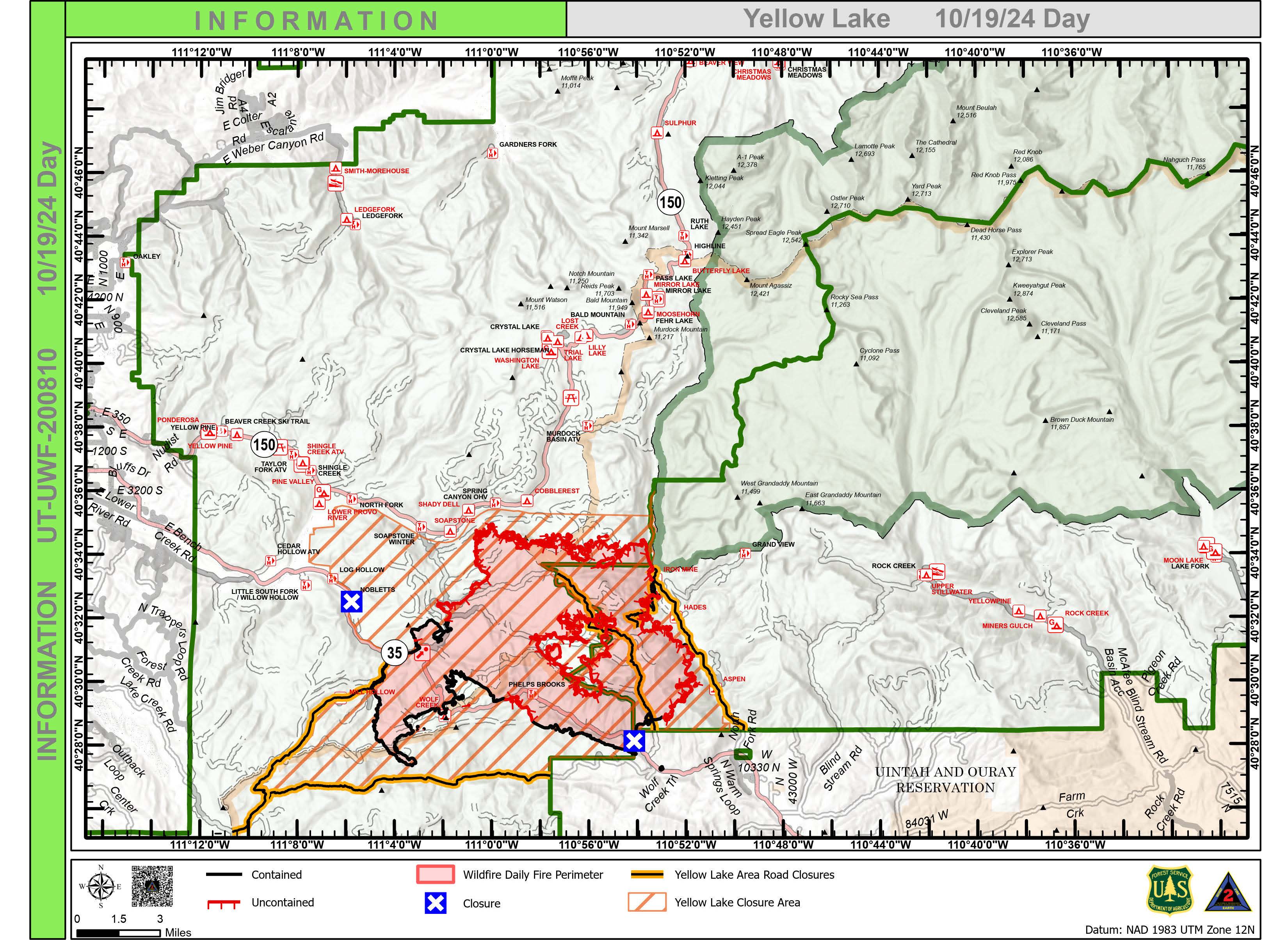
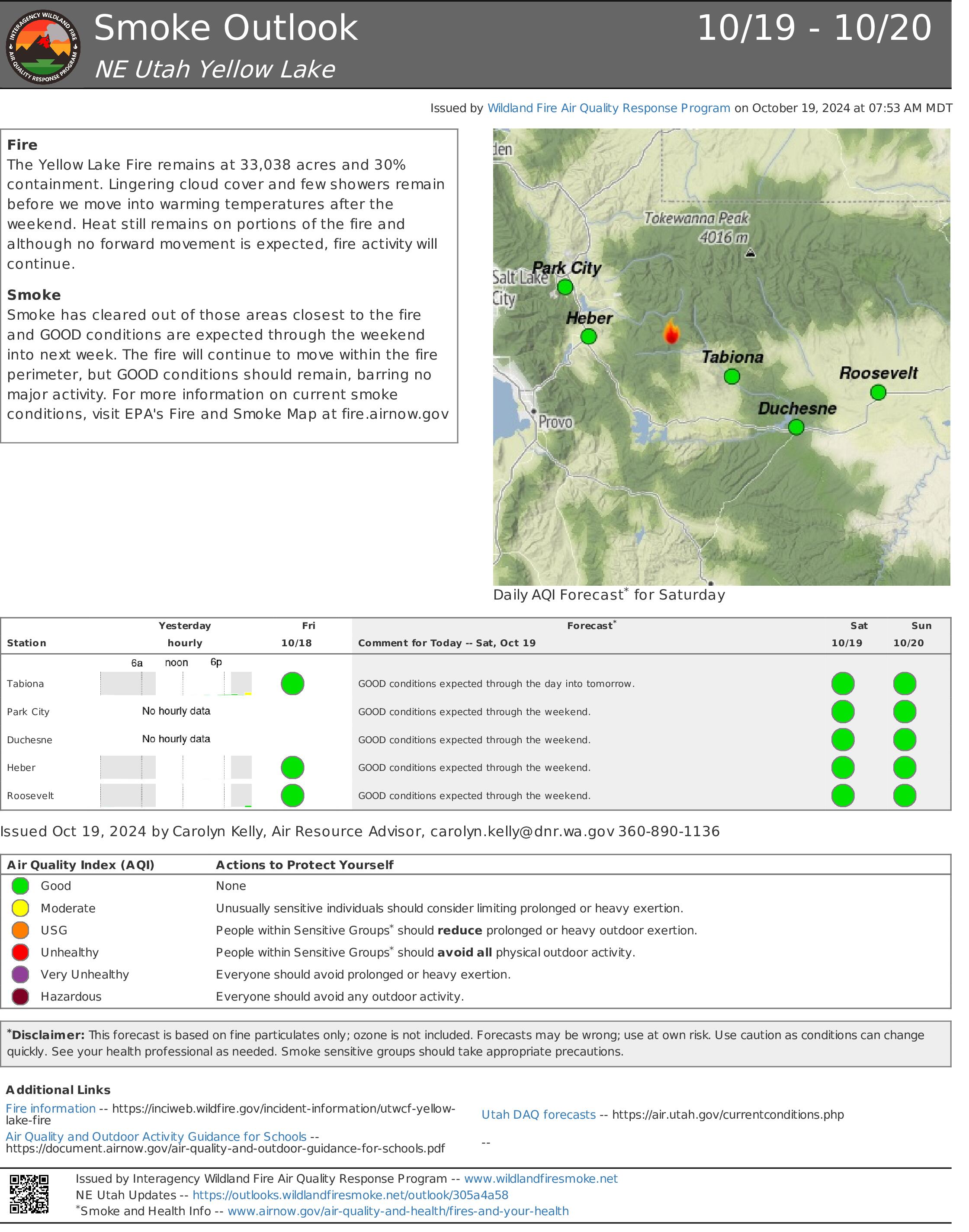
Yellow Lake Fire Update 10 19 2024
Related Incident: Yellow Lake Fire
Publication Type: News
Yellow Lake Fire
Incident Update October 19, 2024
Size at time of update: 33,038 Acres
Containment: 30%
Personnel: 433
Start: Saturday, September 28, 2024
Cause: Human Caused (Under Investigation)
Location: 10 miles southeast of Francis, Utah
Wasatch and Duchesne County evacuation orders were lifted at 9:00 a.m. - Forest closures remain in effect.
Personnel numbers on the Yellow Lake Fire continue to decline as operations ramp down. Six days ago, 889 personnel were on the fire – today there are 433.
Rain and snow fell yesterday with up to 1.23 inches of precipitation recorded. However, fire managers say there is still some heat out there. Aircraft, equipped with infrared technology, flew the fire area last night and detected isolated heat sources on the north side. Hot spots were also picked up along the North Fork of Duchesne, as well as a few in the “donut hole” in the middle of the fire perimeter.
As the weather warms today, smoke from smoldering heavy fuels, duff and leaf litter could show up. An isolated snag torching would not be unexpected. However, fire movement is not expected.
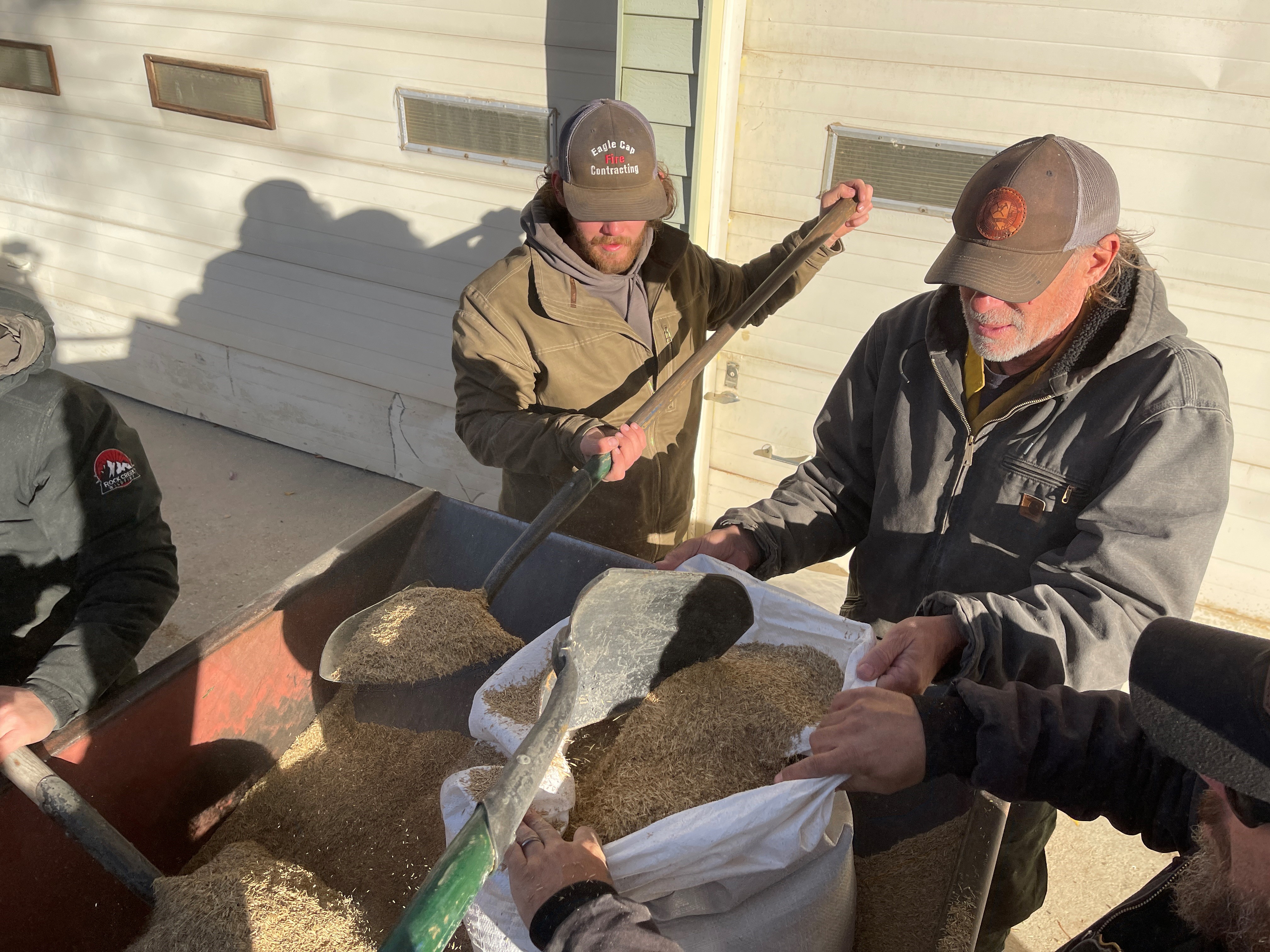
Fire suppression has transitioned to repair of dozer lines, pump and hose removal, and hydrological improvements such as water bars.
A Burned Area Emergency Response (BAER) team will be coming next week to assess damage and recommend ways to mitigate changes to the landscape. Suppression repair is important for water quality, especially within adjacent watersheds. Meanwhile, fire crews are working with local Forest Service Resource Advisors to address immediate repair needs.
A community meeting will be held this afternoon at 4:00 p.m. at the South Summit Middle School Auditorium in Kamas to discuss fire suppression, rehabilitation and what’s next.
Forest Closures:
- Updated October 18, 2024, the Yellow Lake Fire closure area has been reduced on the Uinta-Wasatch-Cache National Forest. This Order shall remain in effect until November 25, 2024, unless rescinded.
https://www.fs.usda.gov/Internet/FSE_DOCUMENTS/fseprd1208350.pdf - Updated October 18, 2024, the Yellow Lake Fire closure area has been reduced on the Ashley National Forest. This closure will remain in place through December 31, 2024, or until rescinded.
For updated evacuation zones, please visit:
https://emergency-management-operations-wasatch.hub.arcgis.com/
https://tricountyemergencyalert.genasys.com/portal/en
https://www.fs.usda.gov/Internet/FSE_DOCUMENTS/fseprd1208878.pdf