
Forest Service Releases Davis PostFire BAER Assessment Report Summary 10 21 2024
Related Incident: Davis Fire Burned Area Emergency Response (BAER)
Publication Type: Announcement
A USDA Forest Service Burned Area Emergency Response (BAER) team has recently finished evaluating the damage caused by the Davis Fire on National Forest lands, producing a report detailing the post-fire assessment and outlining necessary stabilization measures or actions to address potential risks. The BAER team aims to implement these stabilization measures quickly, ideally before the first significant storm event following the fire, to minimize potential damage to critical values, such as to human life and safety, property, and cultural and natural resources.
NOTE: Attached below as “Related Information” is a PDF document called “Davis Post-Fire BAER Assessment Report Summary”.
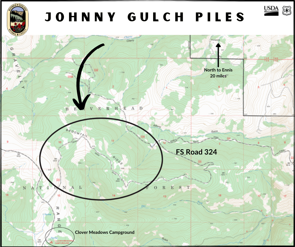
Madison Ranger District Pile Burning Locations 11 05 2024
Related Incident: Beaverhead-Deerlodge NF Prescribed Fire Operations
Publication Type: Announcement
Pile burning locations for the Madison Ranger District include the following:
Johnny Gulch
20 miles south of Ennis
Along Forest Service Road 324, just north of Clover Meadows Campground
Piles remaining from fire suppression operations on the Monument Fire of 2018
Happy Fire Update November 5 2024 11 05 2024
Related Incident: Happy
Publication Type: News
The Happy Fire has provided the opportunity to reintroduce fire back into this landscape. The local management team based on the Sequoia National Forest in coordination with the Sierra National Forest and Kings Canyon National Park has been monitoring and managing the benefits this fire is providing since it began on July 16, 2024.
Forest Officials actively engaged to manage the fire on October 31, 2024 through November 3, 2024 with ignitions north of Hwy 180 along the South Fork of the Kings River, changing the status from a monitored fire to a managed fire.
Aerial and hand crew ignitions over a recent two day period contributed to over 4000 acres of treatment accomplished. Ideal fire effects are providing benefits to natural resources with the treated acreage to 10,571 acres.
Fire activity for the Happy Fire is expected to decrease and smoke has cleared out with the weather change as the fire is now in monitoring status. As the vegetation dries out, smoldering may increase and produce more smoke.
The fire will be monitored until rainfall and winter-like conditions put the fire out. Managed fire can help achieve resource objectives and restore and maintain fire as an essential ecological process. This will be the last update unless there is a significant change in the fire.
Blue Front Fire Update 1152024 11 05 2024
Related Incident: Blue Front Fire
Publication Type: News
Start Date: October 28, 2024
Cause: Unknown
Size: 323 acres
Containment: 75%
Location: 4 miles west of Alto, 9 miles northwest of Ruidoso, located in the Blue 2 wildfire footprint in the White Mountain Wilderness
Resources: One Type 6, USFS engine
Types of vegetation in the area (aka fuels): Grass, shrubs, dead/down fuel
Strategy: Full Suppression with direct and indirect tactics
Road Closures: None
Smoke: There is no smoke showing from the Blue Front Fire
Update: Due to the weather and firefighting efforts there has been no perimeter growth on the Blue Front Fire over a week. Precipitation in the form of snow and rain fell over the fire Sunday and Monday further minimizing any observed fire behavior. Last night’s Infrared flight was canceled due to weather conditions, however, containment has increased to 75%. Additional containment lines will be identified, and an updated map will be released tomorrow.
Fire equipment and personnel remain assigned to the Blue Front fire. Although there are fewer resources, if you are planning to travel in and around the fire area, please use caution and drive carefully.
Weather: Precipitation has diminished. Today is forecasted to be sunny and temperatures in the 50’s. Colder temperatures and snow in the higher elevations are forecast to return on Thursday.
Pile Burn Update 11 05 2024
Related Incident:
Publication Type: News
Lolo NF fire and fuels staff completed 207 acres of pile burning yesterday across many of our districts, work will continue today and throughout the rest of this week, as conditions allow.
Missoula Ranger District: Firefighters will continue pile burning up to 60 acres, 3.5 miles northwest of Lolo Hot Springs .5 miles south of Wagon Mountain and Howard Creek junction. Smoke may be visible from Highway 12.
Ninemile Ranger District: The district plans to burn up to 24 acres of piles located in the Cromwell Creek drainage 3 miles west of District Office. Smoke may be visible from the Ninemile Valley, Alberton and Interstate 90.
Superior Ranger District:
The Superior Ranger District will continue pile burning on the Hall Wood project area located 5 miles north of Superior. The district also plans to pile burn on the West End project located southwest of Haugan. Smoke may be visible from Superior and Interstate 90.
Plains/Thompson Falls Ranger District:
District personnel plan to conduct up to 60 acres of piles on two different project areas located in the Prospect Creek drainage and 11 miles west of Thompson Falls. Smoke may be visible from Highway 200 and Camas Prairie.
Seeley Lake Ranger District:
Firefighters will conduct up to 50 acres of pile burning on the Westside Bypass Project area located 4 miles northwest of Seeley Lake. Smoke may be visible from Seeley Lake and Highway 83.
To learn more about pile burning visit: https://www.fs.usda.gov/main/lolo/fire.
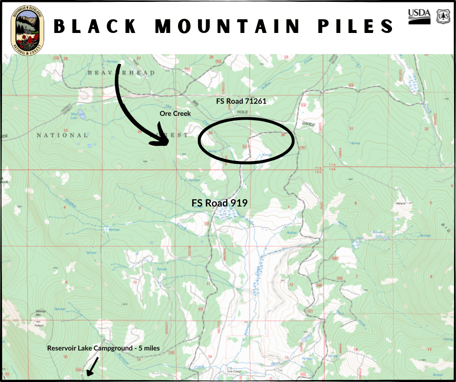
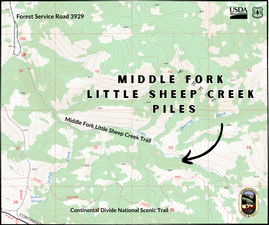
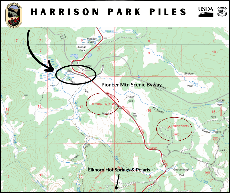
Dillon Ranger District Pile Burning Locations 11 04 2024
Related Incident: Beaverhead-Deerlodge NF Prescribed Fire Operations
Publication Type: Announcement
Pile burning locations for the Dillon Ranger District include the following:
Black Mountain
12 miles south of Jackson
Forest Service Road 919, at Ore Creek and FS Road 71261
Harrison Park Trailhead
10 miles north of Polaris
Off Pioneer Mountain Scenic Byway
Just north of Crystal Park
Middle Fork Little Sheep Creek
10 miles south of Lima
Between CDT and Middle Fork Little Sheep Creek Trail
Pintler Ranger District Pile Burning Locations 11 04 2024
Related Incident: Beaverhead-Deerlodge NF Prescribed Fire Operations
Publication Type: Announcement
Pile burning locations for the Pintler Ranger District include the following:
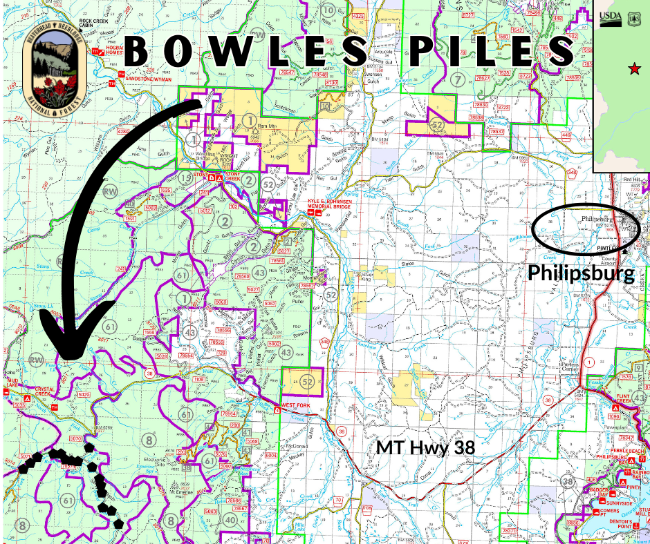
Bowles
22 miles southwest of Philipsburg
South of MT Hwy 38 in the Skalkaho Pass area
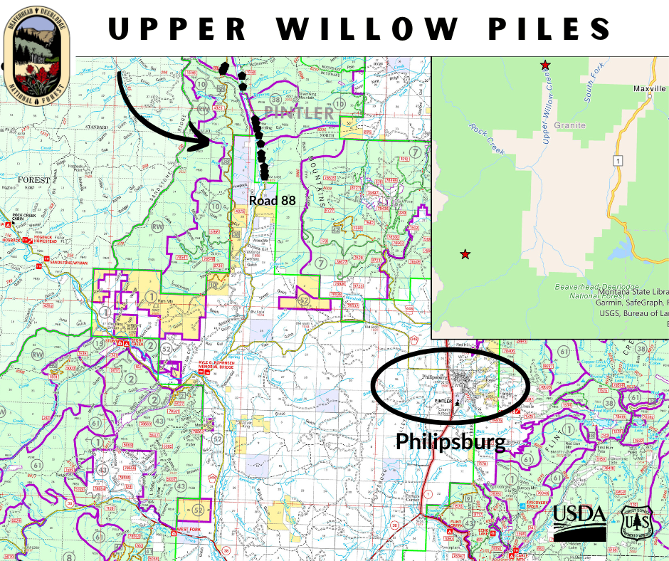
Upper Willow
16 miles northwest of Philipsburg
Along County Road 88 in the Upper Willow Creek area
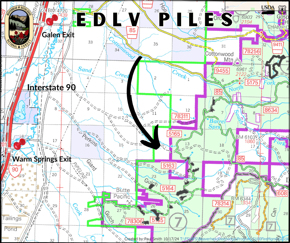
EDLV
10 miles northeast of Opportunity
East of Interstate 90, between Galen and Warm Springs exits
Smoke visible along I-90 and from Opportunity and Anaconda
Hand piles
Smaller hand piles in several locations: Georgetown Lake, East Fork Reservoir, Middle Fork of Rock Creek, Stoney Creek, and Henderson Mountain
Smoke visible from HT Hwy 38, Montana Hwy 1, Georgetown Lake, and Moose Lake areas
Wisdom Ranger District Pile Burning Locations 11 04 2024
Related Incident: Beaverhead-Deerlodge NF Prescribed Fire Operations
Publication Type: Announcement
Pile burning locations for the Wisdom Ranger District include the following:
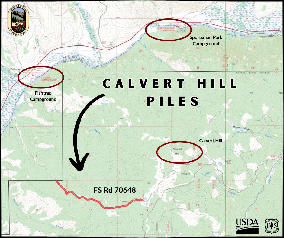
Calvert Hill
19 miles NE of Wisdom
3 miles SE Fishtrap CG
FS Road 70648
Calvert Creek drainage
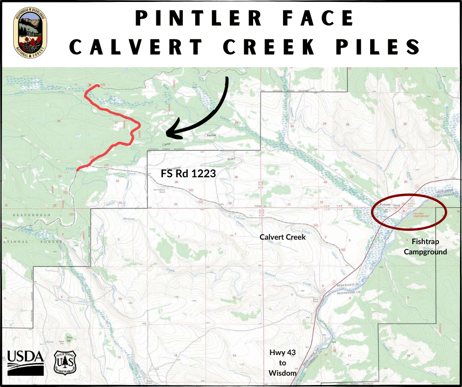
Pintler Face – Calvert
20 miles N Wisdom
5 miles NW Fishtrap CG
FS Road 1223
Calvert Creek drainage
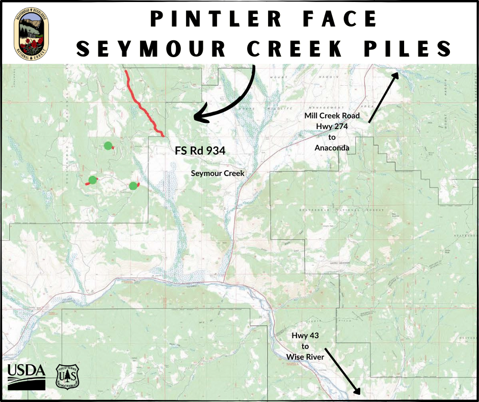
Pintler Face – Seymour
15 miles NW Wise River
W of Mill Creek Hwy 274
FS Road 934
Seymour Creek drainage
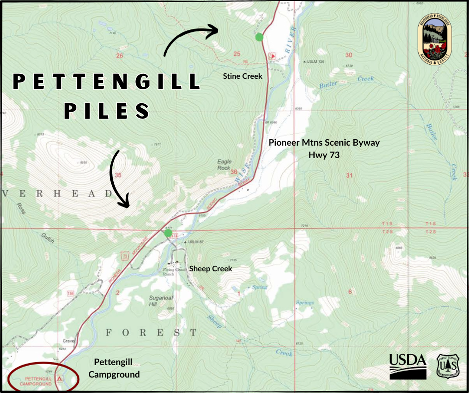
Pettengill Creek
6 miles SW Wise River
Off PMSB Hwy 73
Stine Creek and Sheep Creek
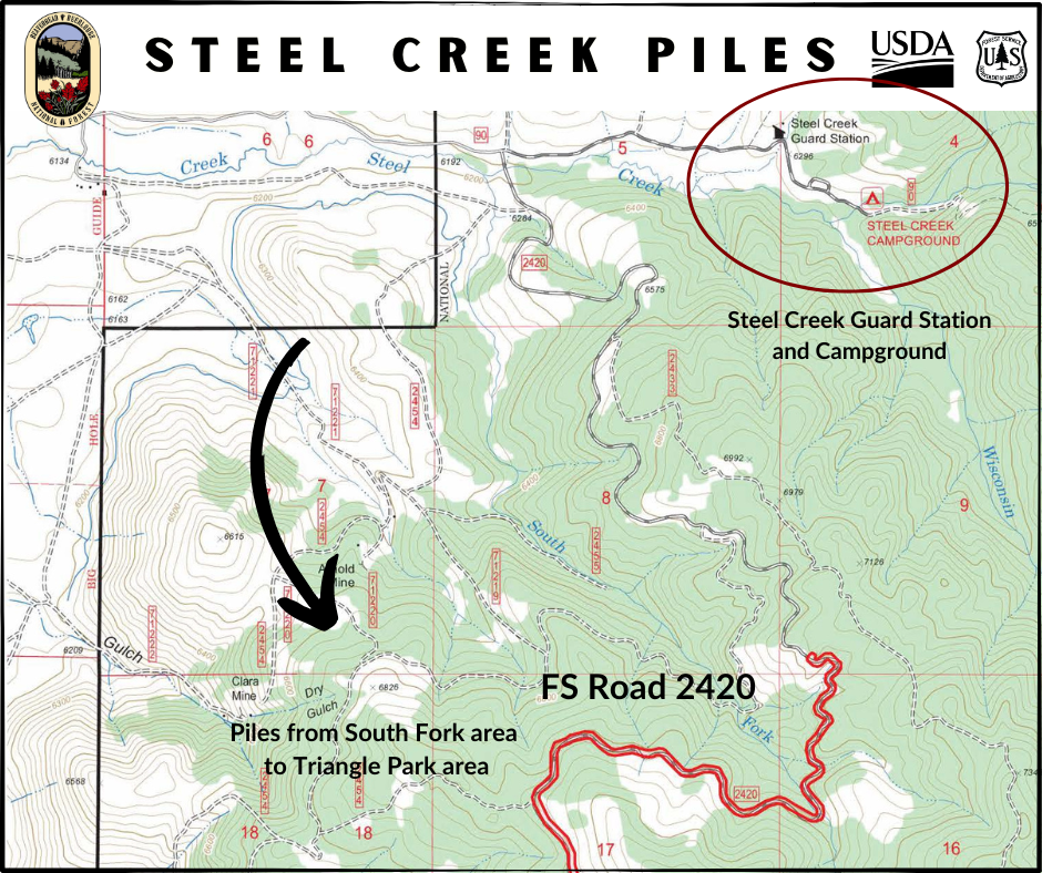
Steel Creek
6 miles E of Wisdom
S of Steel Creek Guard Station & CG
FS Road 2420
From South Fork to Triangle Park area
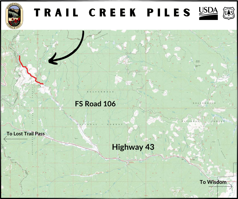
Trail Creek
20 miles W of Wisdom
FS road 106, off Highway 43
Butte Ranger District Pile Burning Locations 11 04 2024
Related Incident: Beaverhead-Deerlodge NF Prescribed Fire Operations
Publication Type: Announcement
Pile burning locations for the Butte Ranger District include the following:
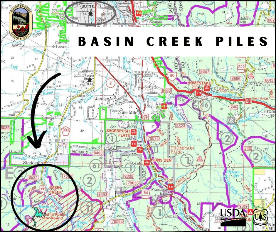
Basin Creek
10 miles south of Butte
Basin Creek Road 393 and in previously treated Basin Creek project area
(10,000+ hand piles)
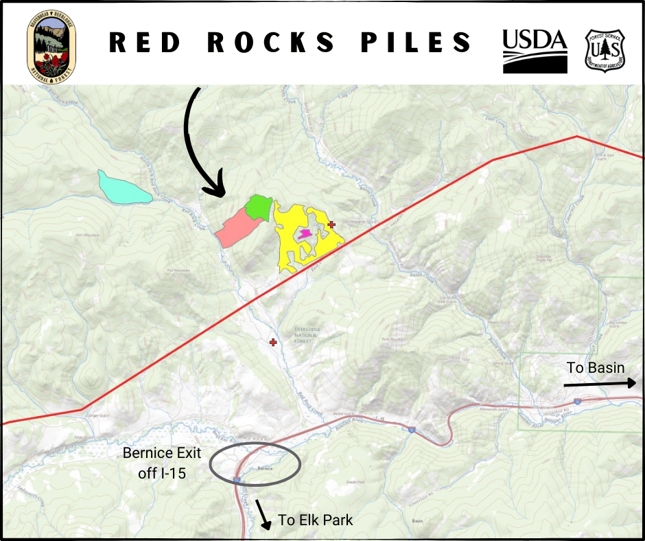
Red Rocks
22 miles north of Butte
2 miles north of Bernice exit off Interstate 15
In Red Rocks drainage
Winter pile burning plans for San Juan NF 10 23 2024
Related Incident: 2025 San Juan National Forest Prescribed Fire Program
Publication Type: News
Slash pile burning planned this fall, winter on San Juan National Forest
Pile burning operations will begin in October 2024, extend into spring 2025
Durango, Colo., Oct. 23, 2024— The San Juan National Forest plans to burn slash piles this fall and winter generated from forest thinning and timber sales. Thinning projects improve forest health and wildlife habitat and reduce the risk of wildfire near private residences and infrastructure. Slash from these projects is piled and burned to remove the debris that could fuel wildfire.
Pile burning will begin as early as this month when there is sufficient snow or rain present to prevent fire spread and will continue as long as conditions allow, possibly through April 2025. Firefighters will ignite and monitor pile burning activities while heat is present. These activities should not affect public access or use of the forest.
Columbine Ranger District plans to burn slash piles near the following locations: Saul’s Creek (50 acres, 100 piles) near Forest Service Road 755. Fossett Gulch (17 acres, 100 piles) near FSR 841. Baldy Mountain (117 acres, 10 piles) near FSRs 69 and 601.
Dolores Ranger District plans to burn slash piles near the following locations: Haycamp Mesa area (250 acres, 800 piles) near FSRs 556, 556.G and 492, south of Beef Pasture Reservoir. Boggy Draw area (14 acres, 4 piles) near FSR 526.B in the Beaver Rim Gravel Pit. Taylor Mesa area (390 acres, 134 piles) near FSRs 545 and 545.J. Salter area (400 acres, 400 piles) near FSRs 514, 504, 519 and 293, northwest of Salter Y. Lake Canyon and Glade areas (3100 acres, 1400 piles) near FSRs 506, 504, 508, 512, 514, 215 , 270, 216 and 218 near Glade Canyon. Smoke may be visible from Highway 184, Highway 145, and U.S. Route 491.
Pagosa Ranger District plans to burn slash piles near the following locations: Turkey Springs Piles, 15 acres, adjacent to Piedra Road and FSR 629. Longest Mile Piles, 7 acres, adjacent to Piedra Stock Driveway Trail. Buckles Lake Road Piles,13 Acres, adjacent to FSR 663 and US Highway 84. Coyote Creek Piles, 15 miles, between FSR 663 and Alpine Lakes Ranch subdivision. Mariposa Timber Sales Piles, 326 acres, 9 miles, near the FSR 024. Huerto Timber Sale Piles, 596 acres, between the Weminuche Valley and Williams Reservoir. Fawn Gulch Piles, 16 acres, north of FSR 666 and Log Park subdivision. Quartz Piles, 20 acres, adjacent to FSR 684.
Burning will only occur when all conditions of the state-issued smoke permit are met. Learn how smoke from wildfires, prescribed burns and pile burns may affect your health by visiting the Colorado Department of Public Health website: https://www.colorado.gov/pacific/cdphe/wood-smoke-and-health.
For additional information on the San Juan National Forest prescribed fire program, visit InciWeb (https://inciweb.wildfire.gov/incident-information/cosjf-2024-san-juan-national-forest-prescribed-fire-program). For information on current conditions and recreation opportunities on the San Juan National Forest, call (970) 247-4874, visit the forest website, or follow us on social media (Twitter and Facebook).
-USDA-
USDA is an equal opportunity provider, employer, and lender.