
North Hart Prescribed Fire Friday Evening Update 10 26 2024
Related Incident:
Publication Type: News
Fire crews began ignitions on the North Hart Prescribed Fire in the Valle Vidal today. Here’s the latest:
- Crews completed 450 acres, burning along the northern edge of the unit on Vermejo Reserve. This method is called blacklining, which reduces fuels along a pre-existing control line, in this case a road, before larger areas are treated within the interior of the prescribed fire unit.
- Ignitions are expected to continue Oct. 26, pending weather conditions. Smoke will continue to be produced with wind forecasted to push it out of the area during the day and lay down locally overnight.
- Fire personnel from various partner agencies participated in today’s work: Vermejo Reserve/Colfax County Fire Dept., Red River Fire Dept. the Nature Conservancy/Ember Alliance and National Park Service. Students from the National Interagency Prescribed Fire Training Center also helped.
Project Background
The North Hart Prescribed Fire is an 1,871-acre cross-boundary burn between Carson National Forest and Vermejo Reserve. It’s the first project on the forest that uses a congressionally authorized tool known as a Wyden Agreement to collaboratively conduct restoration work across boundaries to protect, restore and enhance fish and wildlife habitat.
The unit is about evenly split between Forest Service and Vermejo Reserve lands. The area last experienced fire in 2002 during the Ponil Complex Fire, and this work helps maintain the health of fire-dependent ponderosa stands and grasslands.
Ignition updates are available on InciWeb and by other means. The public can learn more about prescribed fires on the Carson National Forest at fs.usda.gov/goto/CarsonRx.
Mountainair Ranger District Capilla Prescribed Fire FINAL Release 10 25 2024
Related Incident:
Publication Type: News
Capilla Prescribed Fire
Ignitions Completed Today
October 25, 2024 – Today's objectives on the Capilla Prescribed Fire consisted of mopping and holding exterior fire lines as well as the ignition of small, unburned pockets within the perimeter. Today there was an operation focused on unburned pockets of fuel, which was completed around 1:30 PM. Overall, fire crews focused on securing the fire's perimeter and mop-up. Please note, smoke may continue to be visible as unburned or heavy fuels within the perimeter continue to burn. These heat sources should pose no threat to perimeter lines. Fire crews will continue to be onsite daily to monitor and extinguish hot spots as necessary. Unless there are new developments, this will be the final new release specific to the Capilla Rx.
Fire acreage remained at 570 acres. The Capilla Fuels Reduction and Restoration Project in the Manzano Mountains is located approximately 10 miles northwest of the town of Mountainair in the southern half of the Manzano Mountains of Torrance County New Mexico.
Smoke may be visible from Mountainair, Punta de Agua, Manzano, Torreon and Estancia Valley. Visitors to the Red Canyon Campground as well as the Red Canyon, Spruce Spring, New Canyon, and Crest Trails may be affected. There are currently no road or area closures in effect. The Cibola NF & NGs manages all prescribed fires in compliance with New Mexico state air quality and smoke management regulations. However, smoke may settle into drainages and lower elevations at night, and is expected to disperse as temperatures rise in the morning. Information on air quality and protecting your health can be found online at the www.airnow.gov/.
Some objectives for the Capilla Rx include improving wildlife habitat by creating diversity in vegetation, returning fire to the ecosystem in a controlled and efficient manner, and to reduce fuel loadings/raise the canopy cover base to reduce the likelihood of a crown fire, all while providing for the safety of all fire personnel and members of the public.
Our land management strategy is centered on long-term forest health, including reducing forest fuels and using prescribed fire on the landscape. Prescribed fires are intended to reduce hazardous fuels accumulated due to
drought, climate change, insects and disease, and decades of fire suppression. Additionally, fire managers use prescribed fire to improve forest health, remove hazardous fuels, increase firefighter safety, enhance wildlife
habitat, and protect communities and watersheds. Prescribed fires are designed to meet specific objectives and are always managed with firefighter and public safety as the priority.
Implementation announcements and updates on prescribed fire projects will be posted on InciWeb, New Mexico Fire Information and on the Cibola NF & NGs website, Cibola Facebook and Cibola Twitter sites.
If you would like specific information, please contact the Mountainair Ranger District Office at (505) 847-2990 or the Cibola NF & NG Supervisor's Office at (505) 346-3900.
# # #
USDA is an equal opportunity provider, employer, and lender.
Elk Fire Community Meeting Sheridan Junior HS 6 pm Monday 10 28 2024
Related Incident: Elk Fire 2024
Publication Type: Announcement
The Bighorn National Forest is hosting a community meeting on Monday, October 28, at 6 p.m. that will be held at the Early Building Auditorium at Sheridan Junior High School.
Join us for a discussion around Elk Fire updates to include current suppression work and post-fire response, followed by a Q&A with experts.
The meeting will be live streamed on the Bighorn National Forest Facebook page. https://www.facebook.com/bighornnf . If there are any technical difficulties, a recording will be made available afterward.
All Ready Evacuation Statuses Due to the Elk Fire have been Lifted in Sheridan County 10 25 2024
Related Incident: Elk Fire 2024
Publication Type: Announcement
Sheridan County Sheriff’s Office has announced that all "Ready" evacuation statuses related to the Elk Fire have been lifted. No areas within Sheridan County remain under any form of evacuation.
However, several roads will remain closed to ensure the safety of local residents and ongoing firefighting efforts. The following roads are restricted to local residents and fire personnel only:
• Twin Creek Road at Parkman Access
• Smith Creek Road (closed at the dry weather road)
• Tongue Canyon Road (closure moved to Amsden Creek Road intersection)
• Amsden Road
• Little Goose Canyon Road
• PK Lane (intersection of Beckton Road)
Additionally, the following roads are under a hard closure, meaning that only fire personnel are permitted in these areas. For the safety of the public, both vehicles and pedestrians are prohibited from accessing these locations due to heavy fire equipment in operation:
• Red Grade Road (at the winter closure)
All other road closures have been lifted.
Sheridan County will no longer be issuing daily updates unless there are changes to road closures or other significant developments. However, we will continue to share updates from the Bighorn National Forest as needed.
We extend our gratitude to the residents of Sheridan County for staying informed and for their cooperation with evacuation orders and road closures during this emergency.
Sheridan County Emergency Management Phone: 307-752-2174
The Elk Fire information hotline: 307-303-7642
Sheridan County Web Site: www.sheridancountywy.gov
Summit Lake Fire Update October 25 2024 10 25 2024
Related Incident: Summit Lake
Publication Type: News
This update provides an overview of the current status of the Summit Lake Fire for October 25, 2024.
Rail Ridge Daily Update 10 25 2024
Related Incident:
Publication Type: News
Rail Ridge Fire Update
Friday, October 25, 2024
Central Oregon Wildfire Information: centraloregonfire.org
Email: 2024.railridge@firenet.gov ~ Phone: 541-208-7111
Social Media, Evacuation and Closure Information: https://linktr.ee/RailRidgeFire
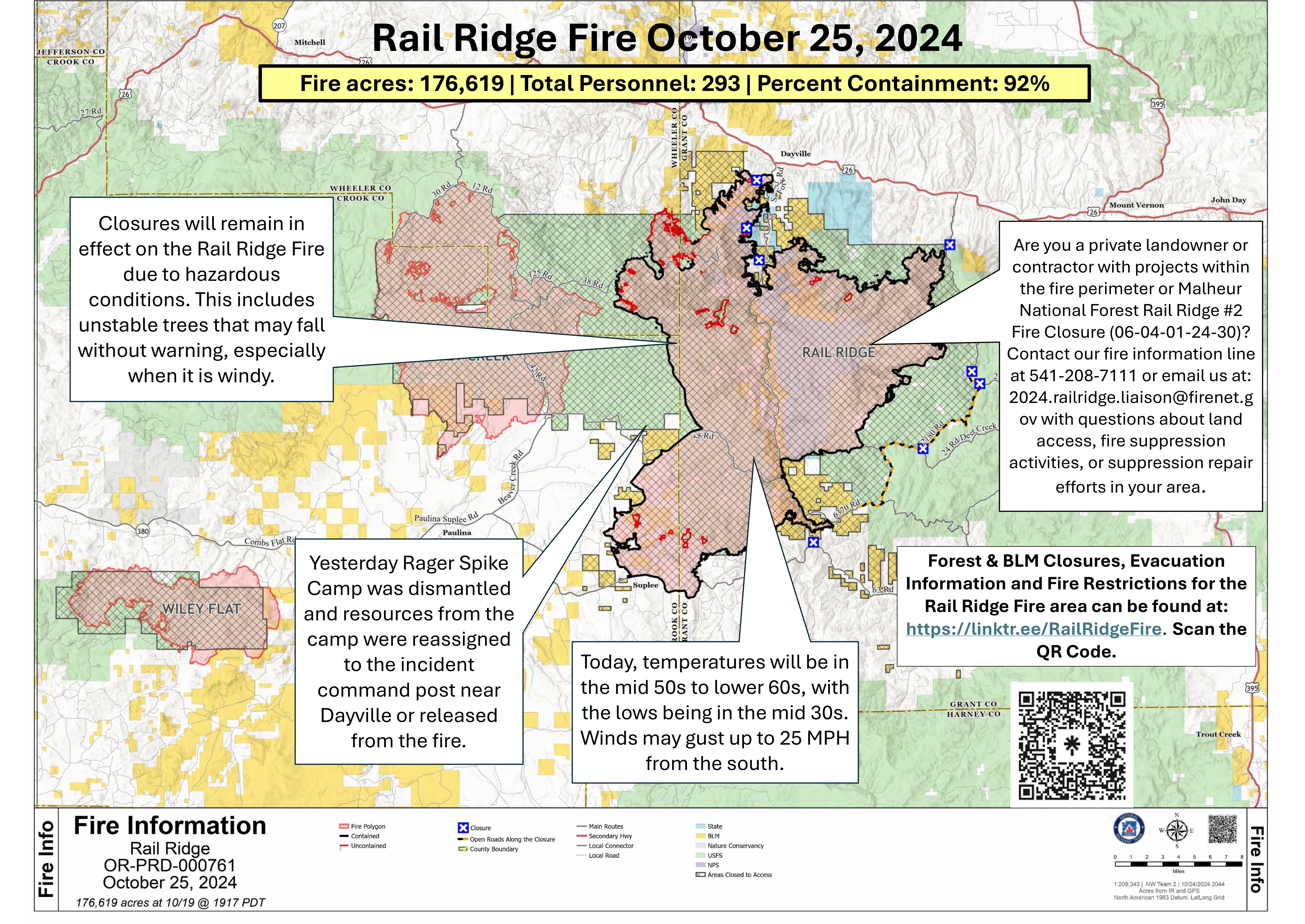
Acres: 176,619 ~ Containment: 92% ~ Start Date: 09/02/24 ~ Cause: Lightning ~ Personnel: 293
**The next Rail Ridge Fire update will be posted Sunday, October 27.**
Hunting and Fire Closure Areas: Closures will remain in effect on the Rail Ridge Fire due to hazardous conditions. Hazards include ground instability, difficult to recognize dangerous hotspots that may be underground, and unstable trees that may fall unexpectedly. Rail Ridge Fire managers encourage forest users to make sure intended camping and hunting areas are not closed due to wildfire activity. Closures of areas of the Rail Ridge Fire have impacted hunting grounds on the Ochoco and Malheur National Forests, BLM lands, and areas managed by ODFW.
Forest access roads are still being utilized by fire crews and equipment completing repair work. Fire Area Closures remain in place for both firefighter and public safety, and public cooperation is appreciated as fire personnel continue project efforts. For more information on closures as well as Wheeler County and Grant County evacuation information, visit https://linktr.ee/RailRidgeFire.
Private Landowners: Are you a private landowner or contractor with projects within the fire perimeter or Malheur National Forest Rail Ridge #2 Fire Closure (06-04-01-24-30)? Contact our fire information line at 541-208-7111, or email us at: 2024.railridge.liaison@firenet.gov with questions about land access, fire suppression activities, or suppression repair efforts in your area.
Operations: Today’s objectives are to continue repairs to Forest Road (FR) 24 and FR 070. Fire personnel are hauling logs from the shaded fuel break off of FR 3850. Grading operations are ongoing on FR 5840 and FR Battle Creek. Yesterday Rager Spike Camp was dismantled and resources from the camp were reassigned to the incident command post near Dayville or released from the fire.
Weather and Fire Behavior: Today, temperatures will be in the mid 50s to lower 60s, with the lows being in the mid 30s. Winds may gust up to 25 MPH from the south. On Saturday we are expecting warmer, dryer conditions with temperatures possibly reaching the 70s. Rain showers and mountain snow will return to the area on Sunday.
USFS & BLM Closures / Evacuation Information / Fire Restrictions / Social Media for the Rail Ridge Fire area can be found at: https://linktr.ee/RailRidgeFire.
Yellow Lake Fire Update 10 25 2024
Related Incident: Yellow Lake Fire
Publication Type: News
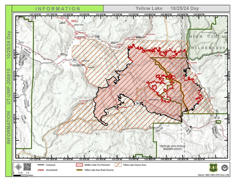
Yesterday, containment on the Yellow Lake Fire area increased to 45%. Now the entire southern perimeter is contained. This is despite a dry front that came through yesterday bringing gusts up to 45 mph on the ridges. The fire did not move beyond the control line in any part of the fire.
The two main efforts of work on the ground continue to be extinguishing areas of heat and repairing damage done by the fire and fire suppression efforts. There are places around the perimeter that have required more attention often due to steep slopes, heavy fuels, and intensive use of heavy equipment. Examples of these areas are Lambert Hollow on the westside, Tim’s Hole on the south side, and the ridge above the North Fork of the Duchesne.
A significant struggle has been the northern perimeter. This jagged line from the Soapstone area, around Iron Mine Mountain, and over to the North Fork of the Duchesne has resisted containment due mostly to the remote rugged terrain. Infrared radiation detected a number of heats near the line that crews have been extinguishing. Because of their work, the line has not moved in over a week even with the prevailing winds coming from the south and southwest testing it.
Major suppression repair work around Heart Lake and West Fork of the Duchesne on the south side of the fire are expected to be finished today. A mini excavator will be coming into the fire today to repair a dozer line above Silver Meadows.
The Burn Area Erosion Response (BAER) team will have an intensive few days on the ground as they assess damage done by the fire. More snow is expected on Monday night around the footprint of the fire. The BAER team hopes to have some of their site visits completed by the next snow.
To request a permit to access property within the forest closures to retrieve important items, livestock, or winterize buildings, please contact the liaison officer at 2024.yellowlake.liaison@firenet.gov.
Forest Closures:
- Updated October 18, 2024, the Yellow Lake Fire closure area has been reduced on the Uinta-Wasatch-Cache National Forest. This Order shall remain in effect until November 25, 2024, unless rescinded.
https://www.fs.usda.gov/alerts/uwcnf/alerts-notices
- Updated October 19, 2024, the Yellow Lake Fire closure area has been reduced on the Ashley National Forest. This closure will remain in place through December 31, 2024, or until rescinded. https://www.fs.usda.gov/alerts/ashley/alerts-notices
Pack Trail Daily Update October 25 2024 10 25 2024
Related Incident:
Publication Type: News
PACK TRAIL FIRE
Friday, October 25, 2024 Update
Fire Information Phone: 307-395-2351 8am-8pm
Email: 2024.Packtrail@firenet.gov
Total Acres: 89,921 Confined: 70% Total Personnel: 631
Operations – On the north side of the Pack Trail Fire, crews continue to complete fire suppression repair where there is little fire activity. Cold trailing continues along the fire edge as safety hazards allow. On the east flank, crews continue to break down structure protection equipment along Highway 26. Firefighters will assess and improve confinement lines along the 540 Road and the Lava Burn Scar connecting to natural features on Lava Mountain. On the southwestern flank, crews continue to secure the fire’s edge, cold trailing from Park Creek west toward Bacon Creek and Bang Creek. The precipitation and cold temperatures continue to aid suppression efforts on the fire. Helicopters are being utilized in the backcountry to backhaul unnecessary equipment and supplies.
Safety – Despite the recent precipitation, Teton Interagency Fire Managers are maintaining the Very High Fire Danger Rating for Grand Teton National Park, the Bridger-Teton National Forest, the Shoshone National Forest, and the National Elk Refuge. This precipitation was not a fire season-ending event. Due to wind, fuels will begin to rapidly dry out when the snow melts. Residents and visitors are reminded to exercise extreme caution when dealing with fires or other possible ignition sources.
Please use caution while driving in these areas, especially on narrow secondary roads. Always expect to encounter fire vehicles and heavy equipment in and around the fire area. Check with WY-DOT for possible closures due to fire activity, especially if you are planning to travel on US-26 across the Continental Divide. Closures are not expected, but with active fire in the area checking status before travel is recommended.
“If you fly, we can’t.” Remember that flying a personal drone over a fire area during a temporary flight restriction is illegal and can be an extremely dangerous threat to both our aviators and firefighters on the ground.
Weather—Today will be mostly cloudy, with temperatures of 47-52 degrees and minimum relative humidities of 20-25%. Winds from the south to southwest will be 4-9 MPH with gusts up to 16 MPH. High pressure will return to the area for the weekend, and with that, we will have clear skies and lower humidities. Snow and rain showers are predicted for the early part of next week. To learn more about air quality, visit Fire.AirNow.Gov.
Evacuations – Evacuation areas have been reduced to a Level 1 “Ready” status for the Union Pass subdivision, Lava Mountain Lodge, Triangle C Ranch, and Old Mackenzie Ranch. All other evacuation areas have been rescinded. See the Fremont County Emergency Management Facebook Page for alerts and updates. See the Teton County Emergency Management website updates and to sign up for emergency alerts through Everbridge.
Road Closures – The Union Pass Road is closed on the Pinedale Ranger District (BTNF) from Mosquito Lake to the Moon Lake Road on the Wind River District (SHO). Moon Lake Road is also closed.
Forest Closures - Closure Order #04-03-24-317 is in effect from October 14, 2024, at 12:00 p.m. through November 15, 2024 at 12:00 a.m. unless rescinded. This order supersedes previous orders, including #04-03-24-316, prohibiting the same or similar acts in the same described area.
For more information, visit: Facebook: USDA Forest Service - Bridger-Teton National Forest, USDA Forest Service - Shoshone National Forest Pack Trail Inciweb: https://inciweb.wildfire.gov/incident-information/wybtf-pack-trail-fire
Elk Fire Update 10 25 2024
Related Incident: Elk Fire 2024
Publication Type: News
Elk Fire Update
Friday, October 25, 2024 - 9:00 a.m.
Rocky Mountain Complex Incident Management Team 1
Dan Dallas, Incident Commander
Special Notes: Given firefighter progress made on suppressing fire activity, predicted future weather, fuel moistures, and lateness of the season, it is unlikely the Elk Fire will grow significantly. The small increase in acres yesterday is due to more accurate mapping. Over the next few days, fire managers will begin taking steps to align the firefighting workforce with expected fire behavior and the remaining work. This will include releasing some resources and transitioning to local leadership while ensuring continuity of objectives and actions.
A community meeting is planned for 6 p.m. Monday, October 28th, at the Sheridan Junior High School, located at 500 Lewis Street. The meeting will be recorded and posted to Facebook and virtual connection will be available through Facebook live streaming at: https://www.facebook.com/bighornnf.
Current Situation: Yesterday, lower elevations received up to ¼ inch of rain while higher elevations received 1-3 inches of snow. These moist conditions resulted in slick and muddy roads, presenting an increased hazard to firefighters. Despite road conditions, firefighters made progress increasing containment as fire activity continued to be minimal. On contained fireline, suppression repair operations were completed on the north side and additional progress was made on east side dozer lines. Heavy equipment operations also continued strengthening indirect firelines.
Today will begin a warming and drying trend expected to last through Sunday, allowing for accelerated progress as roads dry out and the possibility for increased fire activity. Several recent precipitation events across the fire over the last week have kept fire activity low as fine fuel (pine needles and grass) moistures were high. With predicted weather, these fine fuels will dry out, allowing fire activity to pick up slightly. Smoldering and creeping is also likely in heavy fuels (trees and logs) where moisture levels are low and heat has been retained. Firefighters will continue to focus on suppression repair supported with heavy equipment across several divisions while also securing uncontained firelines.
Division A: This division remains unstaffed and aircraft are observing fire activity. No change in tactics will occur today.
Divisions Z, P, M, K, I: Suppression repair work was completed in Divisions Z and P allowing heavy equipment resources to be assigned to other sections of the fire. Divisions M and P were combined with the bulk of work remaining on the eastern edge on the southern end of Division M through Division I. Slick roads prevented access in some areas although work will resume as roads dry out. Actions of the last several days, reducing suppression related impacts to natural resources, will continue today.
Division H: Heavy equipment continued with shaded fuel break development along the Red Grade Road and Forest Road 26 yesterday, and this work will be ongoing today.
Divisions D, F: Firefighters were focused on suppression repair, which included rehabilitating dozer lines in proximity to the Burgess Work Center and Hay Creek, and chipping previously cut vegetation along firelines. Indirect line construction on Forest Road 15 continued. Today, work will be unchanged.
Weather, Fuels, and Fire Behavior: Across the fire area, temperatures will rise more than 10 degrees from yesterday and will be in the upper 40s at higher elevations and range from 65-75 degrees in lower elevations. Humidity will be in the 30-40% range and winds will be light. Fire activity will be minimal with some smoldering, but generally struggling to burn due to retained moisture from yesterday’s precipitation.
Evacuation Notices: A Ready Evacuation status exists for several areas in proximity to the Elk Fire. For additional information about evacuation status, go to Johnson County and Sheridan County respective websites: Johnson County Emergency Management’s Facebook page https://www.facebook.com/JohnsonCoWYEMC and Sheridan County Emergency Management website www.tinyurl.com/2s38bcc5. You may also contact Sheridan County Sheriff’s Office (307-672-3455) or Sheridan County Emergency Management (307-752-2174).
Closures and Advisories: A Temporary Flight Restriction is in place over the Elk Fire. Wildfires are a no-fly zone for unauthorized aircraft, including drones. If you fly, we can’t. For more information, visit http://knowbeforeyoufly.org.
US Highway 14 between Burgess Junction and Dayton is open, restrictions are in place for some commercial vehicles based on weight and size. Red Grade Road and County Road 89 from Dayton to Beckton Junction are closed. County Road 335 is closed from the intersection of County Road 335 and Brinton Road to the west. Additional information may be obtained at https://www.wyoroad.info/.
Bighorn National Forest closure Order No. 02-02-06-24-08 remains in effect. The order and map can be viewed here: https://www.fs.usda.gov/alerts/bighorn/alerts-notices .
Elk Fire Statistics:
Size: 96,935 acres | Containment: 58% | Total Personnel: 458 | Location: West of Sheridan, WY
Reported: September 27, 2024 | Cause: lightning
###
Evergreen Forest Fire Update for Oct 25 2024 10 25 2024
Related Incident:
Publication Type: News
Evergreen Forest Fire Update
Friday, October 25, 2024
MNICS Team C - Incident Commander-Mike Hill transitioning to MN DNR Incident Commander-Randy West
Inciweb: https://inciweb.wildfire.gov/incident-information/mnmns-evergreen- forest
Email: 2024.evergreenforest@firenet.gov
Fire Quick Facts
Size: 167 acres Containment: 90%
Location: Pine City, MN
Cause: Under investigation
Resources: 1 crew, 3 engines, & 6 tracked vehicles
Start Date: 10/17/2024 Total Personnel: 47
Command of the fire transitions back to the MN DNR today. Next Update will be next week.
Current Status: Today at noon, command of the fire will transition back to the Minnesota Department of Natural Resources. Firefighting resources have mopped up 150 feet from the fire’s perimeter and will continue to hold, secure, and reinforce containment lines. The fire is smoldering in timber, logging slash, brush and leaf litter. Firefighters are monitoring leaf drop for potential spotting across containment lines. Firefighter and public safety remain the main priorities for the incident.
Closures: An Emergency Closure Order for all recreation activity remains in effect through the weekend and likely longer to ensure public safety and support firefighting operations. The closure area includes the Chengwatana State Forest Road. Closure information is available on the Inciweb and MNICS website: https://mnics.org/wpress/dnr-temporarily-closing-a- portion-of-chengwatana-state-forest-due-to-wildfire/.
Planned Actions: Resources will continue to hold and secure containment lines. Firefighters will continue mop up along the fire’s perimeter, working inward. Resources will monitor and suppress new hot spots or areas of concern from newly fallen leaf litter. Tracked equipment is being used to traverse the difficult terrain.
Background: The Evergreen Forest Fire was reported on October 17, 2024, on the Chengwatana State Forest, 10 miles east of Pine City, MN. The fire is burning actively in hardwood timber with leaf litter, on Minnesota Department of Natural Resources (DNR) managed land.
Fire Weather Forecast & Air Quality Info: Today, a chance of sprinkles after 1pm, then mostly sunny. High of 56. Breezy, northwest wind 5-9 mph, with gusts up to 21 mph. Tonight-A chance of sprinkles before 1am, otherwise partly cloudy with a low of 28. Northwest wind 5-6 mph, becoming light. Tomorrow-Sunny. High of 50. Winds from the southwest will change to the south 5-10 mph, with gusts up to 15 mph. Air quality is forecasted for “good” for Friday and Saturday. https://www.pca.state.mn.us/air- water-land-climate/air-quality-forecast
Air Operations: Aircraft are available and may be brought in to help support firefighting efforts. A reminder - flying drones over the fire is prohibited. If drones are detected near the fire, any air operations supporting the fire will stop. All media requests, including video, must be coordinate through the Incident Contact listed on the Inciweb page.
Cooperating Agencies: Minnesota Department of Natural Resources, U.S. Fish and Wildlife Service, U.S. Forest Service, National Park Service, Pine County Sheriff’s Department, Pine County Emergency Management, Pine City Fire Department, and Chengwatana Township.