
Pack Trail Daily Update October 27 2024 10 27 2024
Related Incident:
Publication Type: News
Sunday, October 27, 2024 Update
Fire Information Phone: 307-395-2351 8am-8pm
Email: 2024.Packtrail@firenet.gov
Total Acres: 89,930
Confined: 70%
Total Personnel: 503
Operations – On the north and east sides of the Pack Trail Fire, crews continue to complete fire suppression repair; rehabilitating dozer and handlines, road grading, and ditching. Cold trailing continues along the fire perimeter as safety hazards allow. Crews continue to break down and back haul remaining structure protection equipment along Highway 26. On the southwestern flank, crews continue to secure the fire’s edge, cold trailing and extinguishing any remaining visible smoke. Crews are cleaning ditches as the chipping of slash from shaded fuel breaks is complete from Union Pass to the Strawberry Warming Hut area. Crews are repairing fence around Bacon Creek. Precipitation and cold temperatures continue to aid suppression efforts on the fire. Helicopters are being utilized in the backcountry to backhaul unnecessary equipment and supplies.
Safety – Despite the recent and predicted precipitation, Teton Interagency Fire Managers are maintaining the Very High Fire Danger Rating for Grand Teton National Park, the Bridger-Teton National Forest, the Shoshone National Forest, and the National Elk Refuge. This precipitation was not a fire season-ending event. Due to wind, fuels will begin to rapidly dry out when the snow melts. Residents and visitors are reminded to exercise extreme caution when dealing with fires or other possible ignition sources.
Please use caution while driving in these areas, especially on narrow secondary roads. Always expect to encounter fire vehicles and heavy equipment in and around the fire area. Check with WY-DOT for possible closures due to fire activity, especially if you are planning to travel on US-26 across the Continental Divide.
“If you fly, we can’t.” Remember that flying a personal drone over a fire area during a temporary flight restriction is illegal and can be an extremely dangerous threat to our aviators and firefighters on the ground.
Weather—Today will be mostly sunny, with temperatures of 54-59 degrees and minimum relative humidities of 18-23%. Winds from the south to southwest will be 8-13 MPH with gusts up to 28 MPH. High pressure will remain in the area today before a cold front moves into the area on Monday and Tuesday bringing with it rain and snow showers. Accumulations of measurable snow (3-7 inches) are predicted for upper elevations on the fire. To learn more about air quality, visit Fire.AirNow.Gov.
Evacuations – Evacuation areas have been reduced to a Level 1 “Ready” status for the Union Pass subdivision, Lava Mountain Lodge, Triangle C Ranch, and Old Mackenzie Ranch. All other evacuation areas have been rescinded. See the Fremont County Emergency Management Facebook Page for alerts and updates. See the Teton County Emergency Management website updates and to sign up for emergency alerts through Everbridge.
Road Closures – The Union Pass Road is closed on the Pinedale Ranger District (BTNF) from Mosquito Lake to the Moon Lake Road on the Wind River District (SHO). Moon Lake Road is also closed.
Forest Closures - Closure Order #04-03-24-317 is in effect from October 14, 2024, at 12:00 p.m. through November 15, 2024 at 12:00 a.m. unless rescinded. This order supersedes previous orders, including #04-03-24-316, prohibiting the same or similar acts in the same described area.
For more information, visit: Facebook: USDA Forest Service - Bridger-Teton National Forest, USDA Forest Service - Shoshone National Forest Pack Trail Inciweb: https://inciweb.wildfire.gov/incident-information/wybtf-pack-trail-fire
Shoe Fire Daily Update for 10 27 2024
Related Incident: Shoe Fire
Publication Type: News
![]()
SHOE FIRE
DAILY UPDATE
October 27, 2024
Email: 2024.shoe@firenet.gov
Incident Website: https://inciweb.wildfire.gov/incident-information/cashf-shoe-fire
Forest Website: https://www.fs.usda.gov/stnf
Fire Weather Forecast: https://www.weather.gov/wrh/CAFW?area=ECC005
Fire Information Line: 530-338-0317 (Staffed 8:00 AM – 8:00 PM)
Quick Facts:
Location: Shasta County, CA │ Start Date: Wednesday, October 9, 2024, at 6:57 PM │ Cause: Human
Size: 5,124 │ Containment: 60%│ Vegetation: Timber, Chapparal │ Total Personnel Assigned: 839
Aggressive suppression actions over the past few weeks have contributed to an increase in containment. Yesterday, scattered heat lingered in interior areas where heavy logs were smoldering. However, minimal smoke was observed throughout the majority of the fire area. Crews have thoroughly mopped up and gridded much of the fire perimeter that shows little to no heat. Firefighters installed water bars on hand lines and removed excess hose and equipment to be sent back to supply caches. Helicopter crews flew the fire area to assess and verify several temporary landing sites that could be utilized for an emergency.
Today, rain showers will subdue fire behavior and help to keep the fire within the exiting footprint. Excavators continue to repair dozer lines to promote proper drainage on slopes by installing water bars and covering dozer lines with woody debris. This work is essential given the coming rains and potential for erosion and sediment movement into water ways. Masticators are assisting with fire suppression repair and road graders have begun repairing roads due to wear from increased travel by fire resources.
WEATHER: A cold storm system will result in higher humidity and temperatures lowering into the mid to low 50s. Winds will be gusty out of the southwest, up to 20-25 mph on the ridges. Rainfall amounts between 0.25-0.40 inches will be possible between Sunday morning and Monday afternoon. More precipitation is expected later in the week, with rain in the lower elevation and snow possible above 4000 feet.
SMOKE: Updates on smoke conditions can be found under the following link: https://outlooks.wildlandfiresmoke.net/outlook/59ecb6c0?
CLOSURES AND SAFETY:
- Fenders Ferry Road at Pit River 7 Bridge: West-Bound Fenders Ferry Road (Also known as 34N17 - Forest Service Road 27) at the Pit River Bridge/Pit 7
- Ferry Road is closed at McCloud Bridge: East-Bound Fenders Ferry Road at the McCloud River Bridge
- A Temporary Flight Restriction is in place over the fire area https://tfr.faa.gov/save_pages/detail_4_2632.html. Drones are prohibited from flying in fire areas. If you fly, we can’t.
- A temporary Forest closure is in effect https://www.fs.usda.gov/detailfull/stnf/alerts-notices/?cid=stelprdb5392380
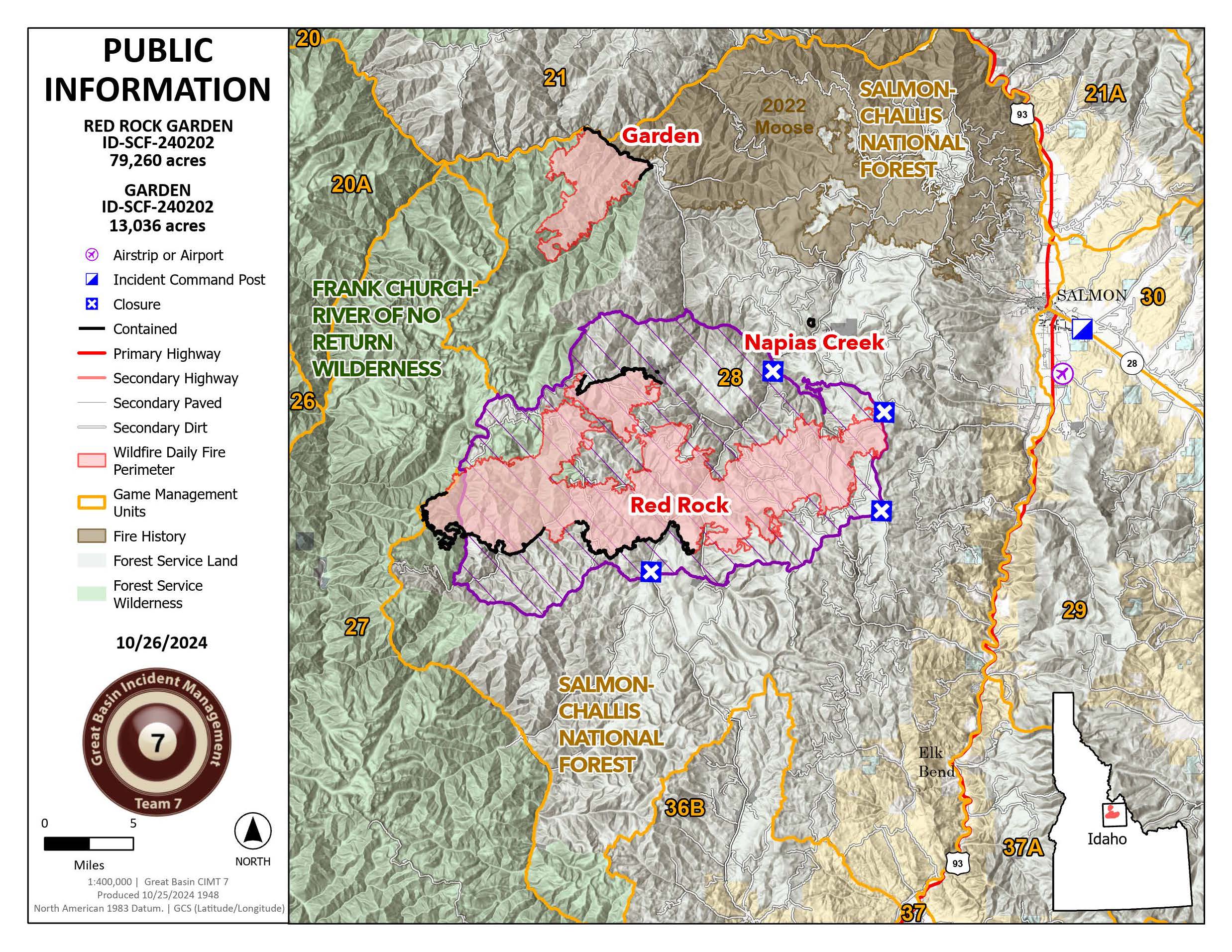
Red Rock Fire Update 10 27 2024
Related Incident:
Publication Type: News
Red Rock Fire
Operations:
Thanks to a favorable weather day, crews have made further progress increasing completion by an additional 8 percent. Fire Managers continue to work closely with local resource advisors to finish repairs and focus the efforts of fire resources prior to the incoming weather. Crews have almost completed the removal of pumps, hoses, and portable water tanks along multiple areas of the fire. Additionally, several pieces of equipment will be finishing repairing dozer line and other areas impacted by fire suppression activities.
Additional Information
Featured Information:
Weather changes have significantly reduced fire activity, prompting a multifaceted suppression strategy for the Red Rock Fire that combines containment and confinement tactics.

- Containment involves establishing control lines expected to halt the fire's spread.
- Confinement uses natural features—such as rock bands, ridges, burn scars, or changes in fuel types—to limit growth.
Both strategies are expressed as percentages, reflecting overall progress. The Red Rock Fire will be reported as completion percentages, with a continued focus on protecting critical assets and ensuring the safety of firefighters and the public.
Weather:
Today will be the beginning of a trend of dropping temperatures, and snow to the upper elevations of the fire. This snow line with be decreasing almost to the valley floor as the system moves through on Monday with snow amounts of up to 4” possible.
The Red Rock Closure Order, Number: 04-13-24-027 remains in effect. Please adhere to closure orders, as this is crucial for the safety of both the public and firefighters. Even in areas with minimal fire activity, crews are continuing to operate heavy equipment and make repairs. Barricades and closures will be posted at road intersections and forest boundaries. In coordination with the Lemhi County Sheriff's Office and the Salmon-Challis National Forest, residents of Yellowjacket and Panther Creek may access their properties via the road, after checking in with the road guard. For more info: https://www.fs.usda.gov/alerts/scnf/alerts-notices.
Elk Fire Daily Update Sunday 10 27 2024
Related Incident: Elk Fire 2024
Publication Type: News
Elk Fire Update
Sunday, October 27, 2024 – 9:00 a.m.
Rocky Mountain Complex Incident Management Team 1
Dan Dallas, Incident Commander
Information Phone: 307-303-7642
Hours: 8 a.m. to 8 p.m.
Email:2024.Elk@firenet.gov
InciWeb: https://inciweb.wildfire.gov/incident-information/wybhf-elk-fire-2024
Facebook:https://www.facebook.com/bighornnf
Information Linktree:https://linktr.ee/2024ElkFire
Special Notes: A community meeting is planned for 6 p.m. Monday, October 28th, at the Sheridan Junior High School, located at 500 Lewis Street. The meeting will be recorded and posted to Facebook and virtual connection will be available through Facebook live streaming at: https://www.facebook.com/bighornnf.
Current Situation: Firefighters took advantage of yesterday’s dry and warm conditions, which allowed for the continuation of suppression repair work and strengthening of indirect firelines. Fire acreage did expand slightly due to field verification of infrared mapping. No actual fire growth occurred. Little change in tactics will occur today, and smoke will once again be noticeable as fuels are consumed in the fire’s interior. Warm, dry temperatures are predicted again, and wind gusts will be escalating throughout the day, ranging from 30-40 mph. These winds will be a good test of firelines, although they pose an increased risk to firefighters due to greater potential for falling burned trees or snags. Extra caution will be required. Firefighters will be striving to complete work where feasible before rain and snow begin tomorrow evening, as significant amounts are predicted.
Division A: This division continues to be unstaffed and observed by aircraft.
Divisions Z, P, M, K, I: Firefighters saw some amplified fire behavior in Division I yesterday, although little change was observed in other divisions. Previous day’s operations will continue being implemented as firefighters try to complete as much suppression repair work as possible before the winter weather arrives.
Division H: Heavy equipment working on the shaded fuel break made headway moving past Long Park on the Red Grade Road and Forest Road 26. More progress is expected today.
Divisions D, F: Suppression repair supported with chipping operations occurred and is expected to conclude tomorrow.
Weather, Fuels, and Fire Behavior: Temperatures will be above normal again today ranging from the 60s to lower 70s depending on elevation. Humidity will be below 20% and winds will range from 12-17 mph. Wind gusts will increase throughout the day and be active overnight as the winter weather storm is pulled into the area. Smoke will continue to be visible due to some active fire behavior where fine fuels are exposed to sunlight, wind, and in proximity to heavy fuels that have held heat. Fire spread outside the current perimeter is unlikely due to the minimal presence of heat sources near firelines.
Evacuations: All evacuations for the Elk Fire have been lifted.
Closures and Advisories: A Temporary Flight Restriction is in place over the Elk Fire. Wildfires are a no-fly zone for unauthorized aircraft, including drones. If you fly, we can’t. For more information, visit http://knowbeforeyoufly.org.
Red Grade Road is closed. US Highway 14 between Burgess Junction and Dayton is open, restrictions are in place for some commercial vehicles based on weight and size. Additional information is at: https://www.wyroad.info/.
Bighorn National Forest closure Order No. 02-02-06-24-08 remains in effect. The order and map can be viewed here: https://www.fs.usda.gov/alerts/bighorn/alerts-notices.
Elk Fire Statistics: Size: 98,185 acres | Containment: 73% | Total Personnel: 529 | Location: West of Sheridan, WY
Reported: September 27, 2024 | Cause: lightning
Final Update 10 27 2024
Related Incident:
Publication Type: News
Fire crews wrapped up much of the treatment on the North Hart Prescribed Fire in Valle Vidal today. Here’s the latest:
- With the assistance of a helicopter, crews completed ignitions on the remaining acres of the 1,871-acre unit. Some clean-up ignitions may occur on Sunday.
- Personnel will pivot to a long-term patrol and monitor plan as fuels continue to burn. Smoke will continue to be visible from the area but not as heavy as during ignitions.
- The completion of ignitions today adds to a large continuous area of forest, now about 24,000 acres, that has been treated with fire over the past several years. The ponderosa and dry mixed conifer forests of the Valle Vidal need regular fire to maintain ecosystem health.
- Like yesterday, fire personnel from various partner agencies participated in today’s work: Vermejo Reserve/Colfax County Fire Dept., Red River Fire Dept. the Nature Conservancy/Ember Alliance and National Park Service. Students from the National Interagency Prescribed Fire Training Center also helped.
- Additionally, fire staff from across the Carson National Forest, as well as from archeology and recreation, came together to make this project happen.
Project Background
The North Hart Prescribed Fire is a cross-boundary burn between Carson National Forest and Vermejo Reserve. It’s the first project on the forest that uses a congressionally authorized tool known as a Wyden Agreement to collaboratively conduct restoration work across boundaries to protect, restore and enhance fish and wildlife habitat.
The unit is about evenly split between Forest Service and Vermejo Reserve lands. The area last experienced fire in 2002 during the Ponil Complex Fire, and this work helps maintain the health of fire-dependent ponderosa stands and grasslands.
The public can learn more about prescribed fires on the Carson National Forest at fs.usda.gov/goto/CarsonRx.
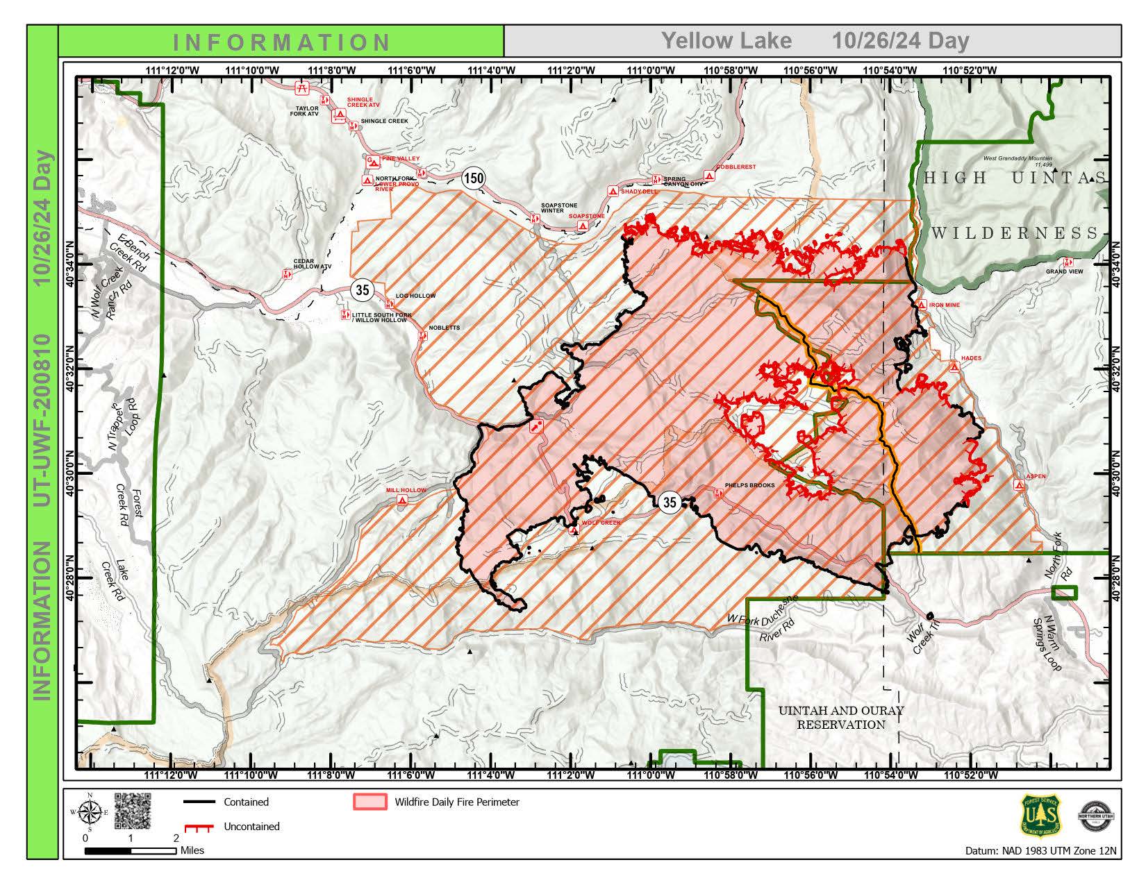
Yellow Lake Fire Update 10 26 2024
Related Incident: Yellow Lake Fire
Publication Type: News
Size at time of update: 33,041 Acres
Containment: 45%
Personnel: 244
Start: Saturday, September 28, 2024
Cause: Human Caused (Under Investigation)
Location: 10 miles southeast of Francis, Utah
As the area dries out between storms, firefighters on Yellow Lake Fire continue to experience smoldering, creeping, and single tree torching. Most of this activity is occurring within the interior and not threatening the line, but there are still significant heat sources showing on the infrared flights.
Temperatures rose to 60 degrees yesterday and are expected to again today, with low humidity. Thankfully, winds were not as strong, allowing crews to continue to directly suppress heat sources.
Containment will likely continue to creep upwards, as crews work their way around the uncontained perimeter. Most of the areas of uncontained line are in steep, rugged terrain that is difficult to access. Firefighters walk the perimeter cold-trailing, using their hand to feel for heat sources and drown and stir any that are identified.
Firefighters continue to work in the contained portions of the fire to repair the areas from damage from the fire as well as suppression efforts, such as dozerline and handline. Heavy equipment has been assisting crews in rehabilitating these areas to minimize the impact and visibility of these lines.
As the Northern Utah Team works diligently, full containment is not likely going to be reached before the predicted storm arrives Monday. These winter storms assist in cooling and slowing the fire, as was seen with the storm last week. However, rain and snow also limit crew access to the fire. The heavy equipment will work until Monday, when it will be removed due to the incoming snow.
The Burn Area Emergency Response (BAER) team will have an intensive few days on the ground as they assess damage done by the fire. More snow is expected on Monday night around the footprint of the fire. The BAER team hopes to have some of their site visits completed by the next snow.
To request a permit to access property within the forest closures to retrieve important items, livestock, or winterize buildings, please contact the liaison officer at 2024.yellowlake.liaison@firenet.gov.
Forest Closures:
- Updated October 18, 2024, the Yellow Lake Fire closure area has been reduced on the Uinta-Wasatch-Cache National Forest. This Order shall remain in effect until November 25, 2024, unless rescinded.
https://www.fs.usda.gov/alerts/uwcnf/alerts-notices
- Updated October 19, 2024, the Yellow Lake Fire closure area has been reduced on the Ashley National Forest. This closure will remain in place through December 31, 2024, or until rescinded. https://www.fs.usda.gov/alerts/ashley/alerts-notices
Pack Trail Daily Update October 26 2024 10 26 2024
Related Incident:
Publication Type: News
PACK TRAIL FIRE
Saturday, October 26, 2024 Update
Fire Information Phone: 307-395-2351 8am-8pm
Email: 2024.Packtrail@firenet.gov
Total Acres: 89,921
Confined: 70%
Total Personnel: 588
Operations – On the north and east sides of the Pack Trail Fire, crews continue to complete fire suppression repair. Cold trailing continues along the fire edge as safety hazards allow. Crews continue to break down structure protection equipment along Highway 26. On the southwestern flank, crews continue to secure the fire’s edge, cold trailing and extinguishing any remaining visible smoke. Crews are chipping slash in shaded fuel breaks and cleaning ditches along forest roads. Precipitation and cold temperatures continue to aid suppression efforts on the fire. Helicopters are being utilized in the backcountry to backhaul unnecessary equipment and supplies.
Safety – Despite the recent and predicted precipitation, Teton Interagency Fire Managers are maintaining the Very High Fire Danger Rating for Grand Teton National Park, the Bridger-Teton National Forest, the Shoshone National Forest, and the National Elk Refuge. This precipitation was not a fire season-ending event. Due to wind, fuels will begin to rapidly dry out when the snow melts. Residents and visitors are reminded to exercise extreme caution when dealing with fires or other possible ignition sources.
Please use caution while driving in these areas, especially on narrow secondary roads. Always expect to encounter fire vehicles and heavy equipment in and around the fire area. Check with WY-DOT for possible closures due to fire activity, especially if you are planning to travel on US-26 across the Continental Divide.
“If you fly, we can’t.” Remember that flying a personal drone over a fire area during a temporary flight restriction is illegal and can be an extremely dangerous threat to our aviators and firefighters on the ground.
Weather—Today will be mostly sunny, with temperatures of 53-58 degrees and minimum relative humidities of 18-23%. Winds from the southwest to west will be 6-11 MPH with gusts up to 20 MPH. High pressure will remain in the area on Sunday before a cold front moves into the area on Monday bringing with it rain and snow showers for the early part of next week. To learn more about air quality, visit Fire.AirNow.Gov.
Evacuations – Evacuation areas have been reduced to a Level 1 “Ready” status for the Union Pass subdivision, Lava Mountain Lodge, Triangle C Ranch, and Old Mackenzie Ranch. All other evacuation areas have been rescinded. See the Fremont County Emergency Management Facebook Page for alerts and updates. See the Teton County Emergency Management website updates and to sign up for emergency alerts through Everbridge.
Road Closures – The Union Pass Road is closed on the Pinedale Ranger District (BTNF) from Mosquito Lake to the Moon Lake Road on the Wind River District (SHO). Moon Lake Road is also closed.
Forest Closures - Closure Order #04-03-24-317 is in effect from October 14, 2024, at 12:00 p.m. through November 15, 2024 at 12:00 a.m. unless rescinded. This order supersedes previous orders, including #04-03-24-316, prohibiting the same or similar acts in the same described area.
For more information, visit: Facebook: USDA Forest Service - Bridger-Teton National Forest, USDA Forest Service - Shoshone National Forest Pack Trail Inciweb: https://inciweb.wildfire.gov/incident-information/wybtf-pack-trail-fire
Shoe Fire Daily Update for 10 26 2024
Related Incident: Shoe Fire
Publication Type: News
SHOE FIRE
DAILY UPDATE
October 26, 2024
Email: 2024.shoe@firenet.gov
Incident Website: https://inciweb.wildfire.gov/incident-information/cashf-shoe-fire
Forest Website: https://www.fs.usda.gov/stnf
Fire Weather Forecast: https://www.weather.gov/wrh/CAFW?area=ECC005
Fire Information Line: 530-338-0317 (Staffed 8:00 AM – 8:00 PM)
Quick Facts:
Location: Shasta County, CA │ Start Date: Wednesday, October 9, 2024, at 6:57 PM │ Cause: Human
Size: 5,129 │ Containment: 52%│ Vegetation: Timber, Chapparal │ Total Personnel Assigned: 902
Fire activity was minimal yesterday with interior areas of the fire smoldering and producing very little smoke. Firefighters continued to add depth to containment lines by gridding for heat as they progressed deeper into the interior of the fire area and extinguished hot spots. Crews sifted through dozer berms checking for heat and extinguishing smoldering and underground fire. Additional heavy equipment resources arrived to engage in fire suppression repair in the coming days. Excess hose and equipment continued to be backhauled from the fire area. Today, firefighters will vigilantly patrol and monitor for flare ups, actively grid burned areas for heat and fire, and continue mop-up operations to fully extinguish remaining hot spots. Chipping and masticating will resume along contingency lines and fire suppression repair needs are being identified by resource advisors. Firefighters assigned to the Shoe Fire will also remain available to assist with any new wildfire starts in the nearby area.
WEATHER: Conditions will remain dry and warm with temperatures in the low to mid 70s. Cloud cover will start moving into the area in the afternoon accompanied by gusty south-southwest winds along ridges. Light rain is anticipated across the fire area Sunday morning as a Pacific frontal system moves onshore with around a quarter of inch of rain expected through Sunday evening.
EVACUATIONS: Due to improving conditions on the Shoe Fire, the Shasta County Sheriff’s Office removed the evacuation order for zone LKH-1448-B yesterday. Forest area closures are in affect as outlined below.
SMOKE: Updates on smoke conditions can be found under the following link: https://outlooks.wildlandfiresmoke.net/outlook/59ecb6c0?
CLOSURES AND SAFETY:
- Fenders Ferry Road at Pit River 7 Bridge: West-Bound Fenders Ferry Road (Also known as 34N17 - Forest Service Road 27) at the Pit River Bridge/Pit 7
- Ferry Road is closed at McCloud Bridge: East-Bound Fenders Ferry Road at the McCloud River Bridge
- A Temporary Flight Restriction is in place over the fire area https://tfr.faa.gov/save_pages/detail_4_2632.html. Drones are prohibited from flying in fire areas. If you fly, we can’t.
- A temporary Forest closure is in effect https://www.fs.usda.gov/detailfull/stnf/alerts-notices/?cid=stelprdb5392380
Elk Fire Daily Update Saturday 10 26 2024
Related Incident: Elk Fire 2024
Publication Type: News
Elk Fire Daily Update
Saturday, October 26, 2024 – 9:00 a.m.
Rocky Mountain Complex Incident Management Team 1
Dan Dallas, Incident Commander
Information Phone: 307-303-7642
Hours: 8 a.m. to 8 p.m.
Email:2024.Elk@firenet.gov
InciWeb: https://inciweb.wildfire.gov/incident-information/wybhf-elk-fire-2024
Facebook:https://www.facebook.com/bighornnf
Information Linktree:https://linktr.ee/2024ElkFire
Special Notes: A community meeting is planned for 6 p.m. Monday, October 28th, at the Sheridan Junior High School, located at 500 Lewis Street. The meeting will be recorded and posted to Facebook and virtual connection will be available through Facebook live streaming at: https://www.facebook.com/bighornnf.
Today only, individuals who received authorization by submitting a request form will be entering the National Forest closure area to retrieve camper trailers and other personal property or check on their cabins. Please drive carefully, especially where firefighters are sharing the roadways.
Current Situation: Containment rose to 73% yesterday as firefighters continued progress on both line construction and suppression repair efforts. Suppression repair is sizeable as more than 155 miles of dozer lines were constructed to stop fire spread when it was actively burning and growing. Over 65 miles have been completed so far. Suppression repair is the first phase of wildfire recovery and is an important component to repairing damage and minimizing soil erosion. The second and third phases of post wildfire recovery are emergency stabilization through Burned Area Emergency Response (BAER), followed by Long-Term Recovery and Reforestation, respectively. BAER is ongoing and consists of doing rapid assessment of burned watersheds to identify and act on imminent post-wildfire threats to human life, safety, property, and critical natural or cultural resources on forest lands. Long-term recovery and reforestation include taking non-emergency actions to improve fire-damaged lands that are unlikely to recover naturally such as reforestation, restoring burned habitat, or treating noxious weeds.
Today, smoke will be visible due to the warmer and drier conditions. Firefighters will be working areas that show smoke and continuing to secure the fire perimeter where necessary. Suppression repair will be ongoing and includes backhauling unneeded supplies and equipment. Weather conditions will be advantageous for road access and operations overall as firefighters work to complete indirect line construction and suppression repair in advance of the incoming winter storm arriving Monday.
Division A: No change; aircraft are monitoring this division as it is unstaffed.
Divisions Z, P, M, K, I: Further division consolidation occurred yesterday with Z, P, and M now being one division. Given the likelihood for snow early next week, firefighters will be striving to complete as much outstanding suppression repair operations as possible before the storm arrives Monday. Crews will continue to work into the fall as possible, and any work not completed will resume in spring once conditions allow the safe return of firefighters and heavy equipment access.
Division H: Fuels reduction operations along the Red Grade Road and Forest Road 26 are progressing. Heavy equipment resources are directed to this division as work is completed on others areas of the fire. Operations will continue today.
Divisions D, F: Suppression repair and chipping operations were ongoing throughout most of the division. Firefighters continued to secure indirect fireline along Forest Road 15. These operations will resume today.
Weather, Fuels, and Fire Behavior:
Weather conditions will warm even more today, reaching the mid-70s in lower elevations and the upper 50s at high elevations. Humidity will be low and in the 20% range possibly dropping into the teens. Winds will be light, similar
to yesterday, with gusts up to 22 mph. Increased smoke will be evident from more active fire behavior, compared to previous days. Fine fuels have dried with yesterday’s warm temperatures and will carry some fire where heat has
been retained. Overall, fire spread will be minimal because of residual moisture content in both vegetation and soils (especially in shaded areas and north facing slopes) from storms over the last week.
Evacuations:
All evacuations for the Elk Fire have been lifted.
Closures and Advisories:
A Temporary Flight Restriction is in place over the Elk Fire. Wildfires are a no-fly zone for unauthorized aircraft, including drones. If you fly, we can’t. For more information, visit http://knowbeforeyoufly.org.
Red Grade Road is closed. US Highway 14 between Burgess Junction and Dayton is open, restrictions are in place for some commercial vehicles based on weight and size. Additional information is at: https://www.wyroad.info/.
Bighorn National Forest closure Order No. 02-02-06-24-08 remains in effect. The order and map can be viewed here: https://www.fs.usda.gov/alerts/bighorn/alerts-notices.
Elk Fire Statistics:
Size: 96,955 acres | Containment: 73% | Total Personnel: 453 | Location: West of Sheridan, WY
Reported: September 27, 2024 | Cause: lightning
Red Rock Fire Update 10 26 2024
Related Incident:
Publication Type: News
Red Rock Fire
Operations:
Taking advantage of the break in weather, crews have made great progress increasing completion by an additional 18 percent. Fire Managers are working closely with local resource advisors to prioritize repairs and focus the efforts of resources prior to the incoming weather. Along the Ridge Road, equipment is continuing to remove downed trees that were cut as part of containment lines. Crews will be finishing the removal of pumps, hoses, and portable water tanks in the Yellowjacket area. Additionally, multiple pieces of equipment will be attempting to finish repairing dozer line across the southern end of the fire.
Additional Information
Featured Information:
Weather changes have significantly reduced fire activity, prompting a revised suppression strategy for the Red Rock Fire that combines containment and confinement tactics.
Containment involves establishing control lines expected to halt the fire's spread, while confinement uses natural features—such as rock bands, ridges, burn scars, or changes in fuel types—to limit growth. Both strategies are expressed as percentages, reflecting overall progress. The Red Rock Fire will be reported as completion percentages, with a continued focus on protecting critical assets and ensuring the safety of firefighters and the public.
Weather: Ahead of the cold front, today’s weather will be warmer with clear skies. Tomorrow will bring dropping temperatures, and snow to the upper elevations of the fire. This snow line with be decreasing almost to the valley floor as the system moves through on Monday.
Closures: The Red Rock Closure Order, Number: 04-13-24-027 remains in effect. Please adhere to closure orders, as this is crucial for the safety of both the public and firefighters. Even in areas with minimal fire activity, crews are continuing to operate heavy equipment and make repairs. Barricades and closures will be posted at road intersections and forest boundaries. In coordination with the Lemhi County Sheriff's Office and the Salmon-Challis National Forest, residents of Yellowjacket and Panther Creek may access their properties via the road, after checking in with the road guard. For more info: https://www.fs.usda.gov/alerts/scnf/alerts-notices.
Evacuations:
All evacuation zones for the Red Rock and Garden fires have been lifted.