
Diamond Complex and Middle Fork Daily Update 08 01 2024
Related Incident: Middle Fork Fire
Publication Type: News
The Diamond Complex on the Umpqua National Forest is estimated at 5,622 acres and 11% contained, with 554 people assigned. The Middle Fork fire within Crater Lake National Park is 728 acres and 1% contained with 46 people assigned. The park remains open. There are fire personnel in the area, so visitors should use caution when traveling within the park.
The Umpqua National Forest increased Public Use Restrictions to Level 3 across all ranger districts of the forest in response to the drying conditions and increased fire activity. More information can be found at bit.ly/3xIZZdK. Broken Arrow, Diamond Lake, and Thielsen View Campgrounds are open and taking reservations through www.recreation.gov
The Trail fire, east of Hwy 138 on the west slope of Mt. Thielsen, is 839 acres and 40% contained. Yesterday, firefighters strengthened fire lines and patrolled the fire. The fire will be monitored from the air and firefighters will respond as needed.
The Lemolo fire, north of Lemolo Lake on Bunker Hill, is 873 acres and 0% contained. Firefighters continued strategic burning operations to strengthen containment on the north edge and made good progress to tie the containment line on the western flank to the Lemolo Lake Road.
The Pine Bench fire, north of Hwy 138 near Dry Creek, is 2,117 acres and 10% contained. Crews continue to hold and mop up along the FS 4775 Road and patrol the 900 Road and Hwy 138. Work is underway to build indirect contingency fire line to the east and north of the fire, to be used if the fire were to move out of the Boulder Creek Wilderness.
Crews on both the Watson fire, 236 acres and 50% contained, and Loafer fire, 37 acres and 50% contained, will continue to mop up these fires.
Bear Trap, 64 acres and 50% contained, 2 miles south of Hwy 138 near Bear Trap Mountain now has a control line around the entire fire and crews are mopping up.
Ooya, 190 acres and 0% contained, north of Hwy 138 about 1 mile northeast of Bird Point. Work is underway to establish safe access to begin active work on the fire. Helicopter bucket drops are helping to keep the fire in check until crews can get to the fire to mop up. There is significant power infrastructure to the south of this fire, making it a high priority as firefighters are reassigned from other fires.
Brodie, 121 acres and 0% contained, about 5 miles south of Hwy 138 and south of Devils Canyon. Teams of fallers and a roadside chipping operation are underway to establish safe and effective access for firefighters, who are employing a mix of direct and indirect line to contain the fire.
Other fires within the complex consist of: Pig Iron near Pig Iron Mountain north of Hwy 138, is 27 acres and 95% contained, Rough, 11 acres and 10% contained, Trep, 133 acres and 0% contained, about 4 miles south of Hwy 138; Garwood, 5 acres and 95% contained, about 3 miles southwest of Mt. Bailey; Slide, 0.1 acres and 95% contained, northeast of Pine Bench; Potter, 747 acres and 0% contained, north of Hwy 138 about 2 miles southeast of Potter Mountain; ; Clearwater, 0.7 acre and 100% contained, south of Hwy 138 about 5 miles northwest of Diamond Lake; Elephant, 0.7 acres and 95% contained, 2 miles southwest of Lemolo Lake; Lost, 25 acres and 0% contained, 4 miles south of Hwy 138; Sheep, 0.3 acres and 95% contained, 3 miles north of Diamond Lake; Thin, 0.6 acre and 95% contained, four miles northwest of Diamond Lake; Trap, 15 acres and 0% contained, 1 mile south of Hwy 138 near Trap Mountain; Campwood, 20 acres and 10% contained, 2 miles south of Hwy 138; Birds, 0.1 acres and 100% contained; Wood, 23 acres and 10% contained, 2 miles south of Hwy 138, Mowich, 0.4 acre and 95% contained, 1 mile north of Hwy 138, Toolbox, 0.1 acres and 95% contained, New 19, 0.1 acres and 0% contained; and Canal, 1 acre and 50% contained.
The Middle Fork fire is in the northwest corner of Crater Lake National Park. Firefighters completed line along the western flank and across the southern end of the fire to check potential fire spread. The Pacific Crest Trail from the Dutton Ridge Intersection to Hwy 138, Lightning Springs, Bald Crater Loop, Bert Creek and Boundary Springs Trails (within the park) are closed until further notice due to potentially hazardous conditions.
Weather: A warming and drying trend is underway, with temperature forecasted to reach the low 90s and relative humidity around 20%. Winds will be from the northwest at 5-8 mph with gusts to 15 mph. There is a chance for scattered thunderstorms this weekend.
Fire Behavior: Fire behavior has been largely limited to surface fire with slow spread. With hotter and drier weather, the fire will become more active, with isolated group torching, short and scattered crown runs are possible.
Smoke Outlook: Smoke production will increase with increased fire behavior. Smoke will remain in the area and may reduce visibility and hinder air operations. For the most up to date information, please visit fire.airnow.gov/
Fire prevention: As the weather warms and dries, the potential for rapid fire growth will increase in this area for the foreseeable future. Please be very careful with any potential ignition sources. Don’t park in dry grass, and make sure tow chains do not drag. Please be mindful of campfire restrictions and appropriate use of liquid fuel stoves.
Closures and Evacuations: Umpqua National Forest has issued two closures across the forest in response to fire activity to protect public and wildland firefighter safety. Emergency Fire Closure ORDER NO. 06-15-24-03 and Emergency Fire Closure ORDER NO. 06-15-02-24-01 impact all of the Cottage Grove Ranger District, most of the Diamond Lake Ranger District, and parts of the Tiller and North Umpqua Ranger Districts. The closure orders can be found here: www.fs.usda.gov/alerts/umpqua/alerts-notices. Fire danger is set at Very High and Public Use Restrictions are set at Level 3: bit.ly/3xIZZdK.
The Douglas County Sheriff’s Office has downgraded the evacuation order for the Trail fire from a Level 2: BE SET to a Level 1: Get Ready, but the Level 3: GO NOW remains in effect for the Trail fire east of Hwy 138. The Level 2: BE SET and Level 3: GO NOW evacuations for the Lemolo fire remain in place. There is still a Level 2: BE SET for the Pine Bench Fire. For more information visit the Douglas County Sheriff’s Office website: www.dcso.com/evacuations
Cougar Creek Fire Update 08 01 2024
Related Incident: Cougar Creek Fire
Publication Type: News
Cougar Creek Fire Update for August 1, 2024
Incident Commander Jeff Dimke
Complex Incident Management Team Northwest 12
509-210-2928, staffed 8 a.m. to 6 p.m.
Quick Facts
Size: 17,602 Acres Start Date: July 15, 2024 Cause: Under investigation
Location: SW of Clarkston, 1 mile west of Hwy 129 and Grand Ronde River intersection
Containment: 29% Personnel: 618 Fire Strategy: Full suppression
Resources Assigned: 11 crews, 2 helicopters, 44 engines, 19 water tenders, 23 heavy equipment
The Cougar Creek Fire is burning within a mountainous and remote area on the Umatilla National Forest bordering the Wenaha-Tucannon Wilderness. At 7 PM yesterday, Complex Incident Management Team 12 assumed operational command of the incident.
Operations: Large fixed-wing air tankers dropped multiple lines of fire retardant along the Forest Service Road (FSR) 40 up to FSR 510 in support of firefighters on the ground yesterday. Crews mopped up smoldering remnants from Tuesday’s firing operation on Hansen Ridge and FSR 4304. Fire managers met yesterday with local land managers to ensure concerns about cattle well-being are addressed in the fire management strategy. Yesterday, the night shift worked on holding and improving fire lines.
Crews may continue to conduct tactical firing operations on FSRs 40 and 43 today as conditions allow. Fire engines and crews from the Cougar Creek Fire will assist local agencies with initial attack on any new fire starts within the Temporary Flight Restriction. Given the difficult terrain near the north edge of FSR 480, firefighters will dig mixed construction line. Structural protection is in place for the residences in the Grouse Flat and Hansen Ridge areas. Crews are preparing the indirect line to the west of Grouse Flat to Three Forks trailhead and south, along with chipping on FSR 43 and 44. In areas where recent burnout operations occurred, pockets of unconsumed fuels will continue to burn in the coming days.
Evacuations and Closures: Forest closure descriptions and maps are available online on the Umatilla National Forest closure website. In Washington, evacuation notices are posted on the Asotin County Sheriff website and Asotin County Emergency Management Facebook website. Grande Ronde Road is closed from Troy, Oregon, to the Highway 129 junction in Washington. In Oregon, a level 2 evacuation is in effect for Wallowa County, including all of Grouse Flat from Bear Creek Road, north to the State boundary and the Garfield County line to Grande Ronde River. There is a Temporary Flight Restriction (TFR) in place over the fire: https://bit.ly/46v7Poj. Drone activity is prohibited under the TFR as firefighting aircraft cannot fly with unauthorized drones present.
Weather and Smoke: There are 20-25 mph gusts forecasted along the ridgelines with low relative humidity expected as the area enters another warming and drying phase. The National Weather Service issued an Excessive Heat Advisory for today through August 3; rising temperatures will lead to increasing fire potential in the coming days. There will be south-southwest wind flows beginning today. Learn more about smoke at http://wasmoke.blogspot.com/.
Oakridge Lightning Fires 2024 Daily Update Thursday 08 01 2024
Related Incident: Willamette Complex Fires - South
Publication Type: News
Fire Update – Oakridge Lightning Fires
Chalk, Coffeepot, McKinley, Moss Mountain, Tire Mountain, 208, and 217 Fires
Thursday, August 1, 2024 – 9:00 a.m.
Rocky Mountain Complex Incident Management Team 1
Dan Dallas, Incident Commander
Information Phone: (541) 208-1742
Email:2024.mossmountain@firenet.gov
Information Staffing Hours: 8 a.m. to 8 p.m.
Special Note: Complex Incident Management Teams (CIMTs) typically work for 14 days before rotating out with another team. Some CIMTs working on other Willamette NF fires will be timing out in the coming days. As a result, Rocky Mountain CIMT1 will assume overall management of the existing crews working on fires outside of the Oakridge Lightning Fires, including taking over management of the Ore Fire starting tomorrow. More details will be provided as this shift in supervision occurs.
Current Situation: Warmer and drier temperatures are forecasted for today and will remain in the area for the next several days. A slight chance of precipitation is possible later in the week; any rainfall is expected to be minimal. Fuels across the Oakridge Lightning Fires are dry and receptive. Burning lichen continues to present challenges to firefighters as it carries flames to very dry and receptive fuels in steep terrain which could provide additional challenges to suppression. Fire activity is expected to increase as smoke rises out of the area today.
The total acreage of the seven fires is 8,106 acres with 713 personnel assigned.
Information for each of the seven Oakridge Lightning Fires is provided below. Firefighting activities and suppression actions are described in detail for each double-lettered division on each fire.
Chalk Fire (3,655 acres, 40% contained)
Division AA: The Chalk Fire is holding along the 1920 Road. Line has been completed and hose is in place. Crews will continue to prepare and strengthen line while also scouting for additional strategic options.
Division KK: The successful firing operation from earlier this week is being secured along the east side of the fire. Resources will continue building and strengthening line along the 1925 Road toward Division TT.
Division TT: Prep work along 1925 Road will continue with equipment and crews strengthening existing line while also looking for additional strategic opportunities for future operations.
Coffeepot Fire (3,956 acres, 0% contained) and Moss Mountain Fire (263 acres, 0% contained)
Division PP: A spot fire on the southwest side of the fire was picked up and addressed yesterday. Crews were able to hold this spot fire overnight and will continue to secure this area today. A contingency crew is in place to assist this division in holding the Coffeepot Fire to the north of highly valued resources south of the fire.
Division RR: Primary line is in place and holding where earlier firing operations have been successful. Additional firing operations are being considered to the west, should conditions allow. Heavy material rolling downhill remains a hazard to firefighters in this difficult terrain.
Division SS: Bulldozers have pushed to the east, tying in this division with Division WW. Equipment will now work west from south of Moss Mountain toward Division PP, while also scouting locations for future strategic operations to protect private land to the south.
Division WW: Crews will continue preparing line along the 2307 Road down to the 23 Road where they expect to be able to tie in with Division SS to the south.
208 Fire (147 acres, 0% contained) and McKinley Fire (24 acres, 0% contained)
These fires continue to show minimal activity over the past several days. The 208 Fire, located entirely in Wilderness, has shown little to no growth. The McKinley fire is being patrolled for any issues that might arise.
Tire Mountain Fire (23 acres, 100%) and 217 Fire (38 acres, 100% contained)
These fires are contained. Staff will continue to patrol and ensure line is holding.
Weather and Fire Behavior:
Much warmer and drier this morning and for the rest of the week. Atmospheric instability will present issues which could allow for a smoke column to form and for fire activity to increase. If the smoke clears, this atmospheric instability may create low level gusts, which has the potential to significantly increase fire activity.
Due to higher temperatures, lower humidity, and potential atmospheric instability, fire activity may increase across all active fires today. Previous spot fires resulting from lichen carrying flames to very receptive fuel indicate that additional spot fires may occur.
Evacuations:
For evacuation information please visit: https://www.LaneCountyOR.gov/2024wildfires
To sign up for evacuation alerts please visit: https://www.LaneAlerts.org
Closures and Fire Restrictions:
Area, road, trail, and recreation site closures are in place on the Willamette National Forest in the vicinity of many active fires. Temporary road barricades are in place to restrict traffic across the fire areas.
For specific closure information follow this link:
https://www.fs.usda.gov/detail/willamette/alerts-notices/?cid=fseprd552029
Fire restrictions on the Willamette National Forest may be found at this link: https://www.fs.usda.gov/alerts/willamette/alerts-notices/?aid=81487
Temporary Flight Restrictions (TFR) are in place over the Chalk and Moss Fires.
Wildfires are a no-fly zone for unauthorized aircraft, including drones. If you fly, we can’t. For more information, visit http://knowbeforeyoufly.org.
For More Information:
Phone: (541) 208-1742
Email: 2024.mossmountain@firenet.gov
InciWeb: https://inciweb.wildfire.gov/incident-information/orwif-oakridge-lightning-fires-2024
Facebook: https://www.facebook.com/OakridgeLightningFires2024/
Total Fire Personnel: 713
Fire Cause: Lightning
Location: North & South of Oakridge, OR
Easy Fire Update 08 01 2024
Related Incident: Easy Fire
Publication Type: News
Easy Fire Update for August 1, 2024
Incident Commander Lonnie Click
Complex Incident Management Team Northwest 3
(541) 861-5808, staffed 8 a.m. to 8 p.m. 2024.pioneer@firenet.gov
Quick Facts
Size: 719 acres
Start Date: July 17, 2024
Location: 17 miles west of Mazama, WA
Containment: 0%
Personnel Assigned: 127
Cause: Lightning
Resources Assigned: 5 crews 7 engines
CURRENT SITUATION: Fire activity was moderate yesterday with continued smoldering within the fire area. The fire is burning on extremely steep slopes where burning logs can roll downhill, further spreading the fire downslope. Crews successfully managed one of these burning debris roll outs that occurred about 100 feet above State Route 20 and kept the fire from encroaching closer to the highway. Firefighters successfully implemented helicopter crew transport to the higher elevations of the Easy Fire, minimizing extensive travel times and exposure risk due to fuel and topography. Work continued along the edge of State Route 20 to chip and clear vegetation away from the highway.
State Route 20 remains open to through traffic with a pilot car escorting vehicles through mileposts 148-157 from 7 a.m. to 8:30 p.m. daily. Expect 30 minutes delays as firefighters continue removing trees and debris from the roadway and conduct full suppression tactics on the Easy Fire. Please do not stop or pull over between mileposts 148-157. With wildfire and firefighting operations still active, the highway may need to close again on short notice. Be sure to check https://wsdot.com/Travel/Real-time/Map/ for the latest information on State Route 20.
TODAY’S ACTIVITIES: As a warming and drying trend builds in the Northwest, fire activity is expected to increase. Crews will continue to use helicopter transport to higher elevation areas on the north side of the Easy Fire. Firefighters will begin preparing the north side of the Easy Fire for potential strategic firing operations from the ridge to the main fire. Firing operations would further secure the fire spread upslope and help prevent additional fire from crossing the ridgeline. Crews will also continue work to bolster handlines in higher elevation areas on both the north and south side of the Easy Fire.
A Temporary Flight Restriction is in place for all aircrafts not involved in wildfire suppression operations. Do not fly a personal drone over or near the Easy Fire. Any incursions create a safety hazard to fire aircraft and require air operations to stop and would be a violation of Federal Aviation Administration regulations.
WEATHER: Temperatures today will increase again reaching the low 100s as a warming and drying builds in the Northwest. Forecasts predict mostly sunny skies with some cumulus buildups in the afternoon and generally warmer and drier. Winds will be west to northwest 1-4 mph and increase to 5-10 mph after 9:00 a.m.
CLOSURES: The Okanogan-Wenatchee National Forest has closures in place for trails within the fire area: https://bit.ly/EasyFireClosures. This closure includes a portion of the Pacific Crest Trail. Campfires are prohibited. There is a Temporary Flight Restriction (TFR) in place over the fire: https://tfr.faa.gov/save_pages/detail_4_6779.html. Unauthorized drone activity is prohibited under the TFR.
EVACUATIONS: There are no evacuations in place for the Easy Fire. Anyone recreating in the area should be vigilant of surroundings and stay out of closed areas.
Facebook: https://www.facebook.com/profile.php?id=61560760893080
Fire Information Line: 541-861-5808, 8 AM to 8 PM
Email: 2024.easy@firenet.gov
Red Fire Update Daily Update 08012024 08 01 2024
Related Incident: Red Fire
Publication Type: News
Red Fire
August 1, 2024
Daily Fire Update
Online: https://inciweb.wildfire.gov/incident-information/ordef-red-fire
Facebook – 2024 Red Fire Information
Fire Information Line: 541-208-1766, 8:00 AM – 8:00 PM
Email: 2024.red@firenet.gov
Red Fire Quick Facts
Size: 447 acres Origin: 5 miles west of Crescent Lake Junction, Oregon County: Klamath
Start Date: July 17, 2024 Cause: Lightning Containment: 0% Total Personnel: 289
Operations: Yesterday, fire crews completed efforts to reduce the grass, brush, small trees, and low-level limbs that serve as ladder fuels around Odell Lake Resort. The shaded fuel break between Crescent Lake and Odell Lake is nearing 60% completion. Firefighters worked with a dozer on Forest Service Road 6010 to improve the access route, and felling crews continued efforts to clear snags and hazards that will make the road more accessible for heavy equipment. Over 550 structure assessments have been completed along the south, west, and north sides of Crescent Lake.
Today, ladder fuel removal continues between Forest Service Road 60 and residences. Crews will begin the shaded fuel break along the north side of Forest Service Road 60, increasing protection of residences and structures around Crescent Lake. Work on the shaded fuel break between Crescent Lake and Odell Lake will continue moving north today. A Deschutes National Forest resource advisor is working with the firefighters to protect significant habitats, resources, and water quality.
Firefighters are closely monitoring weather conditions today as increased fire activity on the Red Fire is expected due to warming temperatures, low humidity, and increased winds this afternoon. Smoke may become more visible today.
Round Mountain & Wickiup Fires: Please be aware fire operations will continue around these fires.
Round Mountain Fire is 108 acres and 75% contained. Firefighters continue to patrol, mop-up, and complete repair work.
The Wickiup Fire is 168 acres and 85% contained. Firefighters continue to patrol and mop-up.
* Deschutes County Sheriff’s Office lifted the evacuation order around the Wickiup Fire.
The Deschutes County Sheriff's Office has dropped all evacuation levels around the Wickiup Fire. This includes the Haner Park area and the Deschutes National Forest between Forest Service Road 4262 and Forest Service Road 44, south of South Century Drive (FS 42) and Burgess Road (FS 43). Temporary emergency closures around the Wickiup Fire decreased to open Bull Bend & Wyeth Campgrounds and Tenino Boat Launch. Temporary emergency closures remain in effect for areas around the Wickiup Fire and Round Mountain Fire.
Closures – The Deschutes National Forest has implemented an emergency closure around Crescent Lake and in the Diamond Peak Wilderness. Closure information is available at: https://www.fs.usda.gov/alerts/deschutes/alerts-notices/?aid=89091
Evacuation Notices – The WILDFIRE! Level 1 – BE READY to Evacuate notice issued by Klamath County Emergency Management for the Crescent Lake, Odell Lake, and Crescent Junction area remains in effect (INCENDIO FORESTAL! Nivel 1 - ESTÉ PREPARADO para evacuar de las siguientes zonas: Crescent Lake, Odell Lake, Crescent Junction). For information, or to sign up for alerts, visit: www.klamathcounty.org/300/emergency-management
Fire Restrictions – Stage 2 Public Use Fire Restrictions which prohibit open fires, including in developed campgrounds, are in effect for the Deschutes National Forest. Visit the Deschutes National Forest’s website fs.usda.gov/detail/deschutes/home/?cid=stelprdb5297376 for more information. The Industrial Fire Precaution Level is currently Level IV “General Shutdown”.
Weather: Highs in the mid-90s. Relative humidity diminishes to 18% and wind gusts up to 20 mph in the afternoon.
Smoke: Smoke from the Red Fire and other area fires will continue to impact air quality. Air quality information can be found at https://fire.airnow.gov/.
Actualizacin diaria del incendio Retreat 1 de agosto 08 01 2024
Related Incident: Retreat
Publication Type: News
Retreat Fire
Información sobre incendios: 509-213-4890 Correo electrónico: 2024.retreat@firenet.gov
inciweb.wildfire.gov/incident-information/wases-retreat
1 de Agosto de 2024
Equipo 1 de Northern Rockies , Comandante del Incidente Brent Olson
Ubicación: 14 millas al suroeste de Naches, WA
Fecha de inicio: 23 de Julio de 2024
Causa: Bajo investigación
Tamaño: 31.514 acres
Contención: 37%
Recursos: 561 personas en total; 8 excavadoras; 11 equipos manuales; 40 camiones de bomberos.
Mensaje Clave:
Las operaciones de fuego han terminado en el lado este del incendio. Las cuadrillas de bomberos trabajarán para limpiar y asegurar las líneas de control en el lado sur y este del incendio.
En los próximos días están previstas operaciones de fuego para asegurar las líneas de control indirecto en los lados norte y oeste del incendio. Habrá un aumento del humo asociado a estas operaciones de fuego que será visible desde las comunidades adyacentes al incendio.
El corredor de la autopista 12 permanece cerrado a la circulación pública tanto para los bomberos como para la seguridad pública. Árboles de gran tamaño afectados por el fuego han estado cayendo sobre la autopista en momentos inesperados. Los equipos y cuadrillas de bomberos siguen trabajando en varios lugares. Se espera que la autopista permanezca cerrada varios días más.
Situación Actual:
El Retreat Fire está siendo completamente administrado con arreglo a una estrategia de supresión total que da prioridad a la seguridad pública y de los bomberos.
Las operaciones de fuego se completaron desde Hatton Road hacia el norte hasta French Road, conectando las líneas de control en el lado este del incendio. La contención aumentó a lo largo de los lados sureste y este del incendio mientras los equipos continuaban limpiando y asegurando la línea. Los bomberos continuarán patrullando y extinguiendo los puntos calientes a lo largo de las líneas de trabajo hacia la contención adicional más cercana a las comunidades de Tieton y Cowiche. Las temperaturas más cálidas y secas permitieron que las operaciones de fuego comenzaran en el lado norte del incendio trabajando a lo largo de la carretera Bethel Ridge (325) como una línea indirecta desde las direcciones este y oeste con equipos de bomberos especializados. Las operaciones de fuego generaron humo en la zona del incendio, pero su objetivo es construir una línea sólida de control a lo largo de todo el lado norte del incendio con el objetivo a largo plazo de lograr una contención adicional.
Los bomberos continuaron patrullando y extinguiendo los puntos calientes a lo largo del lado sur del incendio trabajando principalmente y directamente a lo largo del borde del incendio. Las cuadrillas y el equipo de bomberos continuaron construyendo una línea de control desde la autopista 12 hacia el sur hasta Jump Off Lookout en la esquina suroeste del incendio. Los vientos de levante de última hora de la tarde provocaron algunos pequeños focos de incendio en la zona situada justo al oeste del incendio. Las cuadrillas de bomberos y un helicóptero estaban cerca y pudieron responder y controlar los focos de incendio. El turno de noche patrulló y vigiló estos focos de incendio durante la noche.
Los equipos de protección de estructuras y los camiones de bomberos continuaron patrullando y extinguiendo puntos calientes cerca de viviendas e infraestructuras a lo largo del corredor de la autopista 12 afectado por el incendio, así como retirando árboles caídos y rocas. Las cuadrillas de estructuras también continuaron evaluando y preparando bombas y aspersores alrededor de las estructuras en Camp Ghormley y a lo largo de la carretera de Lost Lake al oeste de la zona del incendio.
Meteorología y Comportamiento del fuego:
Ayer se observaron temperaturas más cálidas y condiciones más secas sobre la zona del incendio con vientos impulsados por el terreno. La tendencia al calentamiento y el secado continuará hoy. Las temperaturas oscilarán entre los 80 y los 90 grados y la humedad relativa disminuirá hasta el 20-30 por ciento. Los vientos soplarán principalmente en superficie y del sureste, a unos 8 a 14 mph con rachas de 15 a 20 mph.
Ayer se inició una tendencia al calentamiento y al secado del clima. En las elevaciones más bajas con artemisa y hierba, el fuego se propagó por la superficie quemando árboles individuales y grupos. En las coníferas mixtas, la actividad del fuego aumentó con el movimiento del fuego terrestre y el incendio de un solo árbol con focos de corto alcance. En la zona del incendio existen tres tipos principales de combustible: salvia/hierba, fondos de roble y bosques de ponderosa. La hierba en los tipos de combustible apropiados está completamente curada y fácilmente disponible para la ignición de fuego. Aunque los robles no están ardiendo, los incendios intensos de pastos bajo estos árboles podrían producir grandes brasas capaces de manchar a corta distancia.
Cierres y Evacuaciones:
Para obtener la información más actualizada sobre evacuaciones, visite la Administración de Emergencias del Condado de Yakima en este enlace: Sitio web de la Administración de Emergencias de Yakima.
-La autopista US 12 permanece cerrada entre la Y de la autopista 410 y la cumbre del puerto en el punto kilométrico 151.
-Cierre de incendios en el Bosque Nacional de Okanogan-Wenatchee: www.fs.usda.gov/alerts/okawen/alerts-notices/?aid=89192.
-La Región Sureste del Departamento de Recursos Naturales del Estado de Washington (DNR) ha cerrado temporalmente el Bosque Estatal de Ahtanum debido al aumento de la actividad del incendio adyacente Retreat Fire que arde cerca de Rimrock Lake. El público puede acceder a la información más actualizada sobre cierres en www.dnr.wa.gov/ahtanum.
El Departamento de Pesca y Vida Silvestre de Washington ha cerrado al público la mayor parte de la zona de Oak Creek debido al incendio de Retreat Fire. Está previsto que la zona natural de Oak Creek permanezca cerrada hasta el 23 de Agosto para garantizar la seguridad pública y facilitar las labores de extinción. Encontrará más información en Áreas silvestres | Departamento de Pesca y Vida Silvestre de Washington.
CALIDAD DEL AIRE Y HUMO
Las condiciones y previsiones sobre la calidad del aire y el humo pueden consultarse en https://www.airnow.gov/.
Recursos para los residentes antes, durante y después del incendio:
Hay muchos recursos en línea disponibles para los residentes de Washington afectados por incendios forestales.
Apoyo a los residentes afectados por los incendios forestales: https://afterthefirewa.dreamhosters.com/
Programas para propietarios de viviendas del DNR de Washington:https://wildfireready.dnr.wa.gov/
https://www.dnr.wa.gov/cost-share
Gwen Fire Daily Update 08 01 2024
Related Incident: 2024 Gwen Fire
Publication Type: News
Rocky Mountain Complex Incident Management Team Three
Bill Waln, Incident Commander
Location: 5 miles east of Lapwai, Idaho Date Reported: July 24, 2024 Cause: Lightning
Size: 28,805 acres Containment: 65% Total Personnel: 307
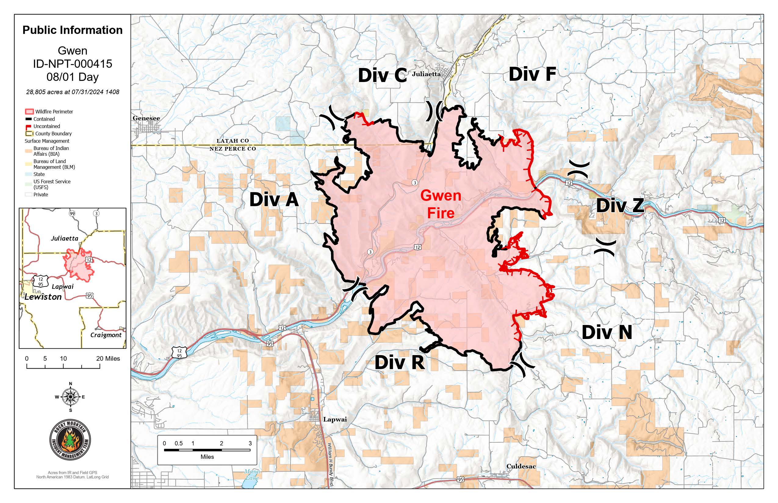
Current Situation: (Refer to the map for Division locations)
- Firefighters worked the north, west and south fire perimeter (Divisions R, A, and C) by mopping up and securing the firelines, resulting in an increase of the fire containment to 65 percent.
- In Division C above Little Potlatch Creek, crews will assess smoldering, fire-weakened trees on slopes near the fire perimeter. Firefighters will remove hazard trees where it is safe to do so.
- Unmanned Aircraft Systems (UAS) will continue to scout for hot spots and document areas disturbed by suppression activities. Fixed wing aircraft will also conduct infrared surveillance to verify ground and UAS findings. Yesterday’s infrared flights confirmed minimal to no hot spots.
- Crews will work along the eastern fireline in Divisions F, Z and N, seeking out and mopping up hot spots. The Structure Protection Group will continue to mop up and secure structure protection around structures inside the fire footprint and along the Highway 12 and Highway 3 corridors.
- There are a few isolated, burning trees and areas where smoldering material inside the fire footprint continues to produce visible smoke.
- Clearwater Electric is continuing their efforts to fully restore power and will be working along the Highway 3 corridor. Be aware there may be temporary delays along the highway. For additional information go to https://www.facebook.com/ClearwaterPower/.
Evacuations: All evacuations are now level 1 (Ready)
Air Quality Information: Please visit https://fire.airnow.gov/ for resources on smoke and air quality. Air quality monitors indicate unhealthy for sensitive groups in the Lapwai area.
Weather and Fire Behavior: Increased temperatures will reach from the high 90s to low 100s, and relative humidity will decrease into the high teens and low twenty percentiles. Northeast winds at 4-9 mph will switch to the southwest at 3-7 mph with gusts up to 12 mph after noon today over the fire except for the area down-valley east of Cherry Lane where the winds will remain northeasterly.
Closures: All roads and highways are open to the public. Hazards remain along the highway, please use extreme caution when traveling in and around the fire area.
GWEN FIRE INFORMATION
Fire Information Phoneline: (208) 843-3534 (Time: 7am-7pm) Email: 2024.Gwen@firenet.gov
Facebook: @IdahoDepartmentofLands InciWeb: inciweb.wildfire.gov
Pyramid and Slate Fires Smoke Outlook 08 01 2024
Related Incident: Pyramid and Slate Fires
Publication Type: Announcement
Ore Fire Update 08 01 2024
Related Incident: Ore Fire
Publication Type: News
Ore Fire Update
Thursday, August 1, 2024 – 9:30 a.m.
Size: 1539 acres | Reported Date: July 16, 2024 | Cause: Under Investigation | Containment: 29%
Total Assigned Personnel: 188 | 6 engines | 1 hand crew | 4 dozers | 18 water tenders | 8 masticators
(Blue River, Ore.) – Fire suppression efforts continue on the Ore Fire, which is burning 7 miles northeast of Blue River, Oregon. Challenges include steep and rugged terrain, rolling rocks and debris and fire-weakened trees. Firefighter and public safety remain the number one priority on the incident. Fire managers are focusing on activities with a high probability of success while minimizing risk to firefighters and protecting values such as communities, infrastructure and forest, recreation and cultural resources.
On Friday, August 2 at 7:00 a.m., command of the Ore Fire will transition to Rocky Mountain Complex Incident Management Team 1 (Rocky Mountain 1). Due to the limited availability of additional incident management teams, all fires on the Willamette National Forest will be combined under a central command structure. A dedicated group of fire managers will remain focused on directing operations on the Ore Fire. While the incident command post for the fire will be relocated, crews and equipment will continue to operate out of Strube Flats. Rocky Mountain 1 will be providing regular communications about the incident.
Yesterday, firefighters continued to mop up and patrol the fire perimeter along the FS 1509 and FS 15 Roads, ensuring rolling debris did not cause spot fires across the line. Hose lays and sprinklers were repositioned from areas of containment to where the fire perimeter is progressing. Additionally, heavy equipment operators played a vital role in widening the FS 1509 and FS 1513 Roads, increasing the likelihood that these features will be successful in stopping fire spread to the north.
Today, fire managers from the incoming team will shadow their counterparts to gain an understanding of current conditions and operations. Line construction will continue, connecting spur roads and natural landscape features from north to south using a combination of handline and dozer line. Chipping of removed woody debris and other fuel mitigation efforts are ongoing along the roadways. Firefighters working on day and night shifts will continue to hold the fire perimeter to the south, preventing fire spread into critical infrastructure and identified values at risk.
Incident Commander Chris Orr and the rest of Northwest Complex Incident Management Team 10 extend their gratitude to our cooperators and partners for their collaboration and assistance. The team also thanks the local residents, business owners and visitors for their appreciation and support during this assignment.
Weather: Under sunny skies, temperatures will climb into the 90s, reaching the upper 90s in unshaded valleys. Isolated dry thunderstorms are possible Friday into Saturday. Thunderstorms may produce showers and gusty outflow winds.
Safety: With incoming hot and dry conditions, fire danger is increasing. The public can help prevent the next wildland fire by observing outdoor burning bans and avoiding other common ignition causes. Fire restrictions are in effect. For additional information, visit https://www.fs.usda.gov/main/willamette/fire. A Temporary Flight Restriction (TFR) was expanded to include the Tidbits Mountain area. Unstaffed Aerial Systems (UAS or drones) are prohibited over the fire area within the TFR. Find out more at: If You Fly, We Can't | US Forest Service (usda.gov)
Smoke: The Ore Fire is producing minimal smoke. However, numerous fires are burning throughout the state, decreasing air quality. A daily smoke outlook can be found at https://wildlandfiresmoke.net. Being prepared for smoke is important. For more information, go to: www.airnow.gov/wildfires/be-smoke-ready.org.
Forest Closures: Closures on the Willamette National Forest have been established around fire-impacted areas, including the following sites: Buck Mountain Trail, Tidbits South and West Trail, Gold Hill Trail, Mona Campground, Lookout Campground, and Saddle Dam Boat Launch. For a complete list of recreation and roads in the Ore Fire closure order, visit https://www.fs.usda.gov/alerts/willamette/alerts-notices.
Badland Complex Daily Update 08 01 2024
Related Incident: Badland Complex 2024
Publication Type: News
Badland Complex Fire Update
Aug. 1, 2024
Rocky Mountain Area Complex Incident Management Team Two
Jared Hohn, Incident Commander
Current Situation:
The Badland Complex remains at 54,563 acres with 73% contained and 270 personnel assigned.
The Coyote Fire is now 100% contained with the completion of containment line to the Snake River to the east along the southern perimeter. The fire will now move into patrol status, supported by an engine and personnel. Expect to see dust devils on this fire which can be mistaken for smoke.
Today, smoke from the Park Fire in California and the Telephone Fire near Burns, Oregon will move into the area. It will block some of the sun’s radiant heat on the Thompson fire, slowing the drying process for vegetation.
The Thompson Fire is now 31,556 acres and 51% contained. Yesterday, crews gained more containment on the northern perimeter near Durkee Creek. Today, a crew from Alaska join the Gila hotshots, hand crews and skidgines. These crews will focus their efforts on completing work to secure handline between Manning Creek Road and Lookout Mountain Road. Expect to see smoke from interior pockets of unburned fuel, which may be visible from I-84.
The Powder, Chalk, Sheep Mountain, Daly, and Crandall Fires are all 100% contained and are in patrol status.
Weather: Yesterday was the first in a series of warmer, drier conditions. Today will begin warmer and drier with more smoke drifting from fires burning in the southwest. The warming trend will continue throughout the day with temperatures in the 100s in the valleys and 90s in the lower elevations. Today will also bring very little wind and an occasional gust of up to 15 mph.
Smoke Information: Air quality is expected to be worse tomorrow as smoke from local and regional fires increase and as the wind patterns become favorable for impacts from the Park Fire in California. For current Oregon air quality conditions, please visit https://oraqi.deq.state.or.us/home/map.
Evacuations: Multiple areas have been reuced to a Level 2 (BE SET) or are no longer under any evacuations. Learn more at https://www.facebook.com/profile.php?id=100064434892363. Sign up for Baker County emergency alerts at https://public.alertsense.com/SignUp/publicUser.aspx?regionid=1357
Closures: Check for highway closures at https://www.tripcheck.com/DynamicReports/Report/RoadConditions. All BLM Vale District Recreation Sites along the Snake River between Oxbow and Huntington and on Lookout Mountain are closed. This includes Spring Recreation Site, Swedes Landing, and Bassar Diggins Campground.
Fire Restrictions: Fire Restrictions are in effect. Get details at https://www.blm.gov/sites/default/files/docs/2024-07/orwa-fpo-val-071024.pdf.
Temporary Flight Restrictions: A temporary flight restriction (TFR) is in effect over the fire area to provide a safe environment for firefighting aircraft operations. View a map of the TFR and details at https://tfr.faa.gov/save_pages/detail_4_7614.html. Fire aviation response is halted or delayed if an unauthorized aircraft enters the TFR. Temporary flight restrictions also apply to unmanned aircraft systems or drones. If you fly, we can’t! Learn more about how to use drones safely and responsibly at Home - Know Before You Fly.
Fire Info Phone: 541-362-1507 Hours: 7:00 a.m. to 7:00 p.m. Email: 2024.badlandcomplex@firenet.gov
Facebook: Facebook Badland Complex Fires 2024 Media Line: 541-249-5894
Inciweb: https://inciweb.wildfire.gov/incident-information/orvad-badland-complex-2024