
Pyramid and Slate Fires Smoke Outlook 08 05 2024
Related Incident: Pyramid and Slate Fires
Publication Type: Announcement
Cougar Creek Fire Update 08 05 2024
Related Incident: Cougar Creek Fire
Publication Type: News
Cougar Creek Fire Update for August 5, 2024
Incident Commander Jeff Dimke
Complex Incident Management Team Northwest 12
509-210-2928, staffed 8 a.m. to 6 p.m.
Quick Facts:
Size: 20,712 Acres
Start Date: July 15, 2024
Cause: Under investigation
Location: SW of Clarkston, 1 mile west of Hwy 129 and Grand Ronde River intersection
Containment: 35%
Personnel: 488
Fire Strategy: Full suppression
Resources Assigned: 8 crews, 3 helicopters, 32 engines, 13 water tenders, 29 heavy equipment
The Cougar Creek Fire is burning within a mountainous and remote area on the Umatilla National Forest bordering the Wenaha-Tucannon Wilderness.
Operations: Precipitation and cooler temperatures moderated fire activity, allowing firefighters to begin constructing an indirect fireline north from Saddle Butte. Heavy equipment cleared vegetation and debris along FSR 40 while firefighters removed hazardous trees on the east side of the road. Fire crews continued to strengthen and deepen firelines north of Saddle Butte and just west of FSR 40 to prevent the fire’s entry into the wilderness. Firefighters are scouting the ridgeline to the east of FSR 40 to assess the viability of stopping the fire on the ridge above the road. Heavy and medium helicopters dropped 20,000 gallons of water yesterday on spot fires on the western fire flank, while firefighters continued working to secure these spot fires below FSR 40. Firefighters will continue securing the spot fires and hope to finish that work today.
Firefighters on the northern portion of the fire continued to hold and secure the area that was burned out Saturday night, while chippers grind activity fuels along FSR 43 to clear roadside debris. Due to the milder weather, fire activity will decrease over the next two to three days, allowing a window of opportunity for firefighters to make progress with more favorable conditions. Risks to structures in the Grouse Flat area continue to decrease as the south flank holds firm. Due to completing their work on the southern fire flank, some heavy equipment in this area will be transferred to higher-priority assignments.
Evacuations and Closures: Forest closure descriptions and maps are available online on the Umatilla National Forest closure website. In Washington, evacuation notices are posted on the Asotin County Sheriff website and Asotin County Emergency Management Facebook website. Grande Ronde Road is closed from Troy, Oregon, to the Highway 129 junction in Washington. A level 2 evacuation remains in effect for all of Grouse Flat from Bear Creek Road north to the State boundary and the Garfield County line to Grande Ronde River. The TFR remains in effect: https://bit.ly/4duptei. Drone activity is prohibited under the TFR as firefighting aircraft cannot fly with unauthorized drones present. Please respect road and area closure orders and use extra caution while driving for your safety as well as our firefighters.
Weather and Smoke: The forecast calls for isolated showers and thunderstorms with dry lightning in the fire vicinity throughout the day. Temperatures this week will rebound to at or below seasonal averages, with relative humidity and overnight recoveries both remaining low. Air quality in the region remains at Moderate quality. Learn more about smoke at http://wasmoke.blogspot.com/.
Actualizacin diaria del incendio Retreat 5 de agosto 08 05 2024
Related Incident: Retreat
Publication Type: News
Retreat Fire
Información sobre incendios: 509-213-4890 Correo electrónico: 2024.retreat@firenet.gov
inciweb.wildfire.gov/incident-information/wases-retreat
5 de Agosto de 2024
Equipo 1 de Northern Rockies , Comandante del Incidente Brent Olson
Ubicación: 14 millas al suroeste de Naches, WA
Fecha de inicio: 23 de Julio de 2024
Causa: Bajo investigación
Superficie: 41.279 acres
Contención: 49%
Recursos: 563 personas en total; 6 excavadoras; 12 equipos manuales; 39 camiones de bomberos.
Mensajes Clave:
Ayer se registraron condiciones meteorológicas más secas en el incendio, con temperaturas cálidas y bajos niveles de humedad relativa. Una zona interior del incendio, cerca de la autopista 12, se activó a última hora de la tarde de ayer, lo que obligó a las cuadrillas de Protección de Estructuras y a los camiones de bomberos a responder con el apoyo de helicópteros que lanzaban agua desde un cubo.
El corredor de la autopista 12 permanece cerrado a la circulación pública tanto para los bomberos como para la seguridad pública. Arboles de gran tamaño afectados por el incendio siguen cayendo sobre la autopista en momentos inesperados y el fuego permanece activo a lo largo de la autopista. Se espera que la autopista permanezca cerrada varios días mas.
Situación Actual:
El Retreat Fire está siendo completamente administrado con una estrategia de supresión total que da prioridad a la seguridad pública y de los bomberos.
Las cuadrillas de Protección de Estructuras siguieron trabajando en la limpieza de árboles y el astillado de maleza y ramas a lo largo del corredor de la autopista 12. También vigilaron la actividad de los incendios en el corredor y respondieron en casos necesario. En la esquina suroeste del incendio, las cuadrillas de bomberos continuaron limpiando y manteniendo la línea de control buscando y extinguiendo los puntos calientes. Además, la maquinaria pesada empezará a trabajar en un cortafuegos a lo largo de las carreteras forestales 1200 y 1201. Esta se está desarrollando como línea alternativa y forma parte de la estrategia global de extinción de incendios. La construcción de un cortafuegos de sombra implica eliminar los combustibles del suelo, despejar la madera muerta y derribada, y ralear algunos árboles para hacer una línea de control más defendible si un incendio se desplaza a la zona.
Los bomberos continuaron limpiando y manteniendo los lados sur y este del incendio. Los equipos de bomberos han progresado grandemente y seguirán patrullando y limpiando para asegurar aún más estas líneas. Se espera que sean necesarios algunos días más de trabajo en estas líneas y las cuadrillas de bomberos seguirán garantizando su seguridad.
Ayer, los equipos de bomberos reanudaron las operaciones de fuego a lo largo del lado norte del incendio y avanzaron a buen ritmo a lo largo del día. Mientras los equipos de tierra trabajaban hacia el oeste, se volvió a utilizar la ignición aérea para rellenar las zonas interiores. Las condiciones meteorológicas fueron mejores que el día anterior logrando los resultados previstos.
Las zonas no quemadas situadas entre el borde activo del incendio y la línea indirecta del lado norte siguieron ardiendo durante todo el día, lo que contribuyó a parte del humo visible desde la zona del incendio.
Meteorología y Comportamiento del Fuego:
Habian nubes esta mañana temprano con algunos chubascos cerca de la zona del incendio. La pauta cambiará un poco, con más viento del sur y sureste durante el día. Las velocidades del viento serán de 5-11 mph con rachas de 24 mph. Se esperan temperaturas máximas de 78 a 84 grados en las crestas y niveles mínimos de humedad del 20-26%.
Los combustibles de salvia/hierba a una altitud aproximada de 4200 pies y por debajo se han curado en su mayor parte con la propagación del fuego a zonas más dispersas que anteriormente no se consumían. A mayor altitud, la salvia y la hierba están parcialmente curadas y arderán con humedad relativa baja y viento. La hojarasca por encima de los 1.500 metros de altitud está seca y arde por completo. Los incendios intensos de pastos bajo los robles podrían producir grandes brasas capaces de manchar a corta distancia.
Cierres y Evacuaciones:
Para obtener la información más actualizada sobre evacuaciones, visite la Administración de Emergencias del Condado de Yakima en este enlace: Sitio web de la Administración de Emergencias de Yakima.
- La autopista 12 permanece cerrada entre la Y de la autopista 410 y la cima del puerto en el punto kilométrico 151.
- Cierre de incendios en el Bosque Nacional Okanogan-Wenatchee : www.fs.usda.gov/alerts/okawen/alerts-notices/?aid=89192.
- La Región Sureste del Departamento de Recursos Naturales del Estado de Washington (DNR) ha cerrado temporalmente el Bosque Estatal de Ahtanum debido al aumento de la actividad del incendio adyacente Retreat Fire que arde cerca de Rimrock Lake. El público puede acceder a la información más actualizada sobre cierres en www.dnr.wa.gov/ahtanum.
- El Departamento de Pesca y Vida Silvestre de Washington ha cerrado al acceso público la mayor parte de la zona silvestre de Oak Creek debido al incendio de Retreat Fire. Está previsto que la zona natural de Oak Creek permanezca cerrada hasta el 23 de Agosto para garantizar la seguridad pública y facilitar las labores de extinción. Encontrará más información en Áreas silvestres | Departamento de Pesca y Vida Silvestre de Washington.
CALIDAD DEL AIRE Y HUMO
Las condiciones y previsiones sobre la calidad del aire y el humo pueden consultarse en https://www.airnow.gov/.
Recursos para los residentes antes, durante y después del incendio:
Hay muchos recursos en línea disponibles para los residentes de Washington afectados por incendios forestales.
Apoyo a los residentes afectados por los incendios forestales: https://afterthefirewa.dreamhosters.com/
Programas para propietarios de viviendas del DNR de Washington:https://wildfireready.dnr.wa.gov/
Courtrock Fire Update Monday 08 05 2024
Related Incident: Courtrock Fire
Publication Type: News
Acres: 20,018 acres
Start Date: July 21st, 2024
Cause: Lightning
Fuels: Timber, grass, brush
Containment: 57%
Resources: 415
Resources are Available to Assist in Case of New Fire Starts
MONUMENT, Ore. –In the aftermath of the lightning storm that moved through eastern Oregon on Sunday near the Courtrock Fire, resources that are assigned to the main Courtrock Fire are now aiding local agencies in initial attacks as reports of smoke or new fires start coming in.
Overview: Firefighters were busy on Sunday extinguishing and removing burning material near control lines. Additional operational resources and overhead are arriving to the Long Creek Incident Command Post today to aid in the mop-up and containment efforts. The area of the fire that did experience some activity over the weekend was in the upper eastern area and well within the interior. This activity poses no threat to the fire’s edge, and the growth will continue to consume the available fuels that are still within the Courtrock Fire perimeter.
On the eastern edge of the fire, headway is being made improving the depth of the control line. An infrared flight, which detects a fire’s intensity and activity, was conducted Saturday night. The data revealed significantly fewer heat signatures compared to the previous night. This reduction in heat was a result of the hard work of the firefighters, both during the night and day shifts. Work continues today to further extinguish hotspots within the perimeter.
Weather: Temperatures will be similar to Sunday, mid-80s up to around 100 degrees across the fire area. Calm winds out of the north/northeast are expected, with ridgeline gusts from 15-20 mph. No significant weather concerns are forecasted, though there is a slight chance for thunderstorms to the east of the fire area this afternoon.
Evacuations: No Level 3 (Go Now) evacuations are in effect.
- For Grant County evacuation information, visit Grant County Emergency Management Office’s Facebook page, or sign up for the Grant County Emergency Alert System at https://member.everbridge.net/825462649520134/login.
- For Morrow County evacuation information, visit the link below.
Shelters:
- Evacuation center is set up at Grant Union High School, 911 S Canyon Blvd., John Day, OR 97845.
Closures:
- The U.S. Forest Service has issued closures for the Malheur National Forest. For Malheur National Forest closures information, visit https://www.fs.usda.gov/news/malheur/news-events•
Retreat Fire Update 08 05 2024
Related Incident: Retreat
Publication Type: News
Retreat Fire
Washington State Department of National Resources
Fire Information: 509-213-4890 Email: 2024.retreat@firenet.gov
inciweb.wildfire.gov/incident-information/wases-retreat
August 5, 2024
Northern Rockies Team 1, Incident Commander Brent Olson
Location: 14 miles southwest of Naches, WA
Start Date: July 23, 2024
Cause: Under Investigation
Size: 41,279 acres
Containment: 49%
Resources: 563 Total Personnel; 6 Dozers; 12 Hand Crews; 39 Engines
Key Messages:
Dryer weather conditions were experienced on the fire yesterday with hot temperatures and low relative humidity levels. An interior area of the fire near Highway 12 became active late yesterday afternoon requiring Structure Protection crews and engines to respond with support from helicopter bucket water drops.
The Highway 12 corridor remains closed to public travel for both firefighter and public safety. Fire affected large trees continue to fall across the highway at unexpected times and the fire remains active along the highway. The highway is expected to remain closed for several days.
Current Status:
The Retreat Fire is being managed under a full suppression strategy prioritizing public and firefighter safety.
Structure Protection crews continued to work on clearing trees and chipping brush and branches along the Highway 12 corridor. They also monitored fire activity in the corridor and responded as necessary. On the southwest corner of the fire, crews continued to mop up and hold the control line by seeking out and extinguishing hot spots. Additionally, heavy equipment will start working on a shaded fuels break along Forest Roads 1200 and 1201. This is being developed as an alternate line and is part of the overall fire suppression strategy. Constructing a shaded fuels break involves removing brush and ground fuels, clearing out dead and downed wood, and thinning out some trees to make a control line more defensible if a fire moves into the area.
Firefighters continued to mop up and hold the south and east sides of the fire. Crews have been making good progress and will continue to patrol and mop up to further secure these lines. A few more days of work is expected to be needed along these lines and crews will continue to ensure that they remain secure.
Yesterday, crews resumed firing operations along the northern side of the fire and made good progress throughout the day. As ground crews worked their way to the west, aerial ignition was again utilized to fill in the interior areas. Weather conditions were better than the previous day to achieve the intended outcomes.
Unburnt areas located between the active fire edge and the north side indirect line continued to burn throughout the day which contributed to some of the smoke visible from the fire area.
Weather and Fire Behavior:
Clouds moved in early this morning with some showers near the fire area. The pattern will shift some, with more south and southeast wind during the day. Wind speeds will be 5-11 mph with gusts to 24 mph. High temperatures of 78 to 84 degrees are expected on the ridges and minimum humidity levels will be 20-26%.
Sage/grass fuels at approximately 4200 foot elevation and below are mostly cured with fire spread into more sparse areas that previously did not consume. At higher elevations sage and grass are partially cured and will burn with low end relative humidity and wind. Timber litter above 5000 foot elevation is dry and burning fully. Intense grass fires below the oak trees could produce large embers capable of short-range spotting.
Closures and Evacuations:
For the most up-to-date information on evacuations, please visit Yakima County Emergency Management located at this link: Yakima Emergency Management website.
- US Hwy 12 remains closed between the Y at Hwy 410 and the summit of the Pass at milepost 151.
- Okanogan-Wenatchee National Forest Retreat Fire Closure: www.fs.usda.gov/alerts/okawen/alerts-notices/?aid=89192.
- The Washington State Department of Natural Resources (DNR) Southeast Region has temporarily closed the Ahtanum State Forest due to increased activity from the adjacent Retreat Fire burning near Rimrock Lake. The public can access the most up-to-date closure information at www.dnr.wa.gov/ahtanum.
- Washington Department of Fish and Wildlife has closed the majority of the Oak Creek Wildlife Area to public access due to the Retreat Fire. The Oak Creek Wildlife Area is scheduled to remain closed until Aug. 23 to ensure public safety and facilitate firefighting efforts. More information can be found at Wildlife Areas | Washington Department of Fish & Wildlife.
AIR QUALITY AND SMOKE
Air quality and smoke conditions and forecasts can be found at https://www.airnow.gov/
Resident Resources Before, During, and After the Fire:
There are many online resources available for Washington residents who are affected by wildfire.
Support for residents being affected by wildfires: https://afterthefirewa.dreamhosters.com/
Washington DNR Homeowner programs: https://wildfireready.dnr.wa.gov/
https://www.dnr.wa.gov/cost-share
Daily Operational Video for the Sand Stone and Deer Fires 08 05 2024
Related Incident: Sand Stone
Publication Type: Announcement
Daily Operational Video for the Sand Stone and Deer Fires
Facebook link: https://fb.watch/tMHKfWhe_t/
Daily Update for the Sand Stone and Deer Fires 08 05 2024
Related Incident: Sand Stone
Publication Type: News
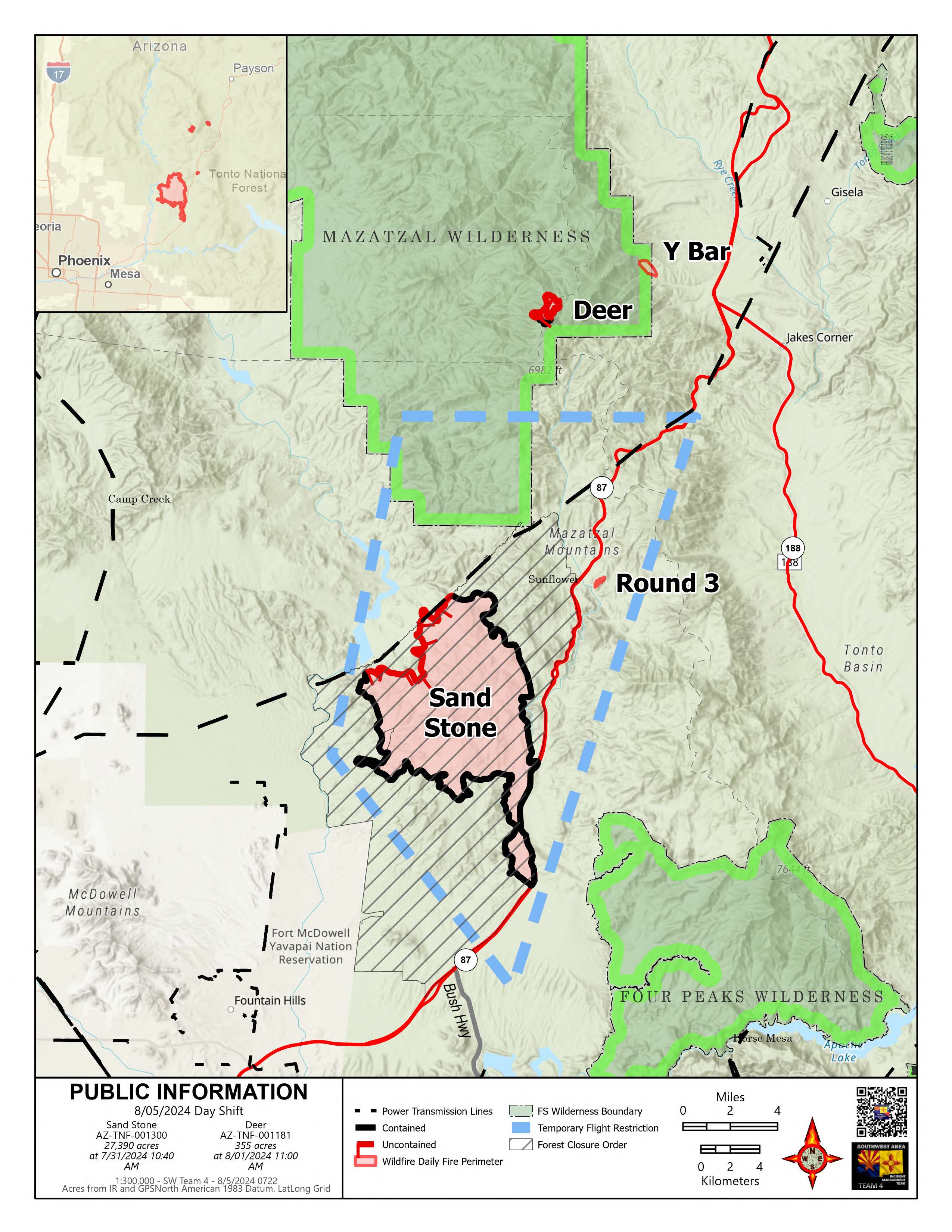
Multiple new fire starts near the Sand Stone and Deer Fire areas
Daily Update – Monday, August 5, 2024
Highlights: Due to record-breaking temperatures, outflow winds, and over 800 cloud-to-ground lightning strikes, several new fires started near the Sand Stone and Deer Fire areas yesterday. The Southwest Incident Management Team 4 is responding to two new fire starts within their designated planning area. The Y Bar Fire is located approximately 5 miles east of the Deer Fire and initially estimated at 150 acres. The Round 3 Fire is located near Bushnell, east of State Route 87 and mapped at 33 acres. Firefighting resources have been dispatched to fully suppress these two new lightning-caused fires. Overnight, crews were able to successfully stop the forward progress of the Round 3 Fire. Today, firefighters are continuing to respond to the Y Bar Fire. Crews will conduct an aerial reconnaissance flight early this morning to assess the progress of all fires and look for any additional new starts. Firefighting resources are also assisting with multiple other new fire starts across the Tonto National Forest, as needed.
Total personnel on all incidents: 353
Sand Stone Fire: Acres: 27,390 Containment: 78% Start Date: 7/25/2024 Fuels: Grass, brush
Operations: Despite weather conditions, the Sand Stone Fire showed little activity yesterday. Ground crews previously engaged with mastication, suppression repair, and other preparatory efforts are being redirected to immediate suppression actions on the new fires identified yesterday. Available helicopters assisted with water bucket drops as weather conditions allowed. Ground crews continued their work into the night to take advantage of every opportunity to contain these new starts. Additional resources, including aviation support, have been ordered to aid in the fire suppression efforts. An additional initial attack crew remains positioned near the community of Sunflower to manage any potential threats to structures. Drivers should use caution and be aware of firefighters working along State Route 87.
Deer Fire: Acres: 355 Containment: 18% Start Date: 7/17/2024 Fuels: Grass, brush, timber
Operations: Minimal fire activity was present on the Deer Fire yesterday. Preparation activities were redirected due to lightning in the area and new fire starts requiring support from ground resources. Firefighters worked overnight to protect structures near Y Bar Ranch. Crews will remain staged around Deer Creek and Rye to protect these values from the nearby Deer and Y Bar Fires.
Weather: An Excessive Heat Warning remains in effect for the Sand Stone Fire area into this evening with above normal temperatures occurring at the higher-elevation Deer Fire. Afternoon thunderstorms are also expected to develop near the fire area today with gusty outflows. A disturbance may bring an increase in moisture and slightly cooler temperatures with more widespread showers and thunderstorms on Tuesday and Wednesday. A return to monsoon conditions with hot temperatures and scattered afternoon thunderstorms is likely for the second half of the week.
Smoke: Smoke may be visible from Fountain Hills, Sunflower, Rio Verde, Goldfield, and unincorporated communities in the Rio Verde Foothills. An interactive smoke map is available at https://fire.airnow.gov/.
Closures: The Tonto National Forest has issued a closure order for the Sand Stone Fire. More information can be found on the Tonto National Forest website: https://www.fs.usda.gov/alerts/tonto/alerts-notices/. Trail users should avoid using the Arizona National Scenic Trail near the fire area.
Safety: The health and safety of firefighters and the public are always the first priority. A temporary flight restriction (TFR) is in place over the area, which includes uncrewed aircraft or drones. Flying drones near wildfires is dangerous for pilots and firefighters and can bring wildfire suppression efforts to a halt. Know before you fly. If you fly, we can’t. More information can be found at: https://uas.nifc.gov/.
More Information: https://inciweb.wildfire.gov/incident-information/aztnf-sand-stone /
480-409-9683 / https://www.facebook.com/TontoNationalForest / 2024.sandstone@firenet.gov
Ore Fire Update 08 05 2024
Related Incident: Ore Fire
Publication Type: News
Current Situation: The Ore Fire is one of 10 fires being managed by the Rocky Mountain Complex Incident Management Team 1, all of which are on the Willamette National Forest. Fire suppression efforts continue on the Ore Fire, which is burning 7 miles northeast of Blue River, Oregon. Currently the fire is 1874 acres and 29% contained. Firefighters continue to strengthen and build primary and contingency lines around the northwestern and northeastern sides of the fire. Heavy equipment operators will continue to remove woody debris and other fuels, and chipping operations will continue. Firefighters will be working closely with Resource Advisors to minimize the impact of fire suppression activities.
Division A: Containment line is complete, and crews will continue securing and patrolling firelines.
Division D: The secondary contingency line is near completion and hose lays and sprinklers have been strategically placed near areas of increased fire activity. Crews are utilizing strategic firing operations to reinforce containment lines and are continuing to patrol and secure firelines.
Division J/W: Work continues on completing contingency lines with heavy equipment clearing trees and fuels, chipping operations have continued as part of this work.
Division Z: Crews built on to previous days’ progress, further securing and patrolling firelines. Contingency lines were strengthened and monitoring and patrolling continues across the division.
Weather & Fuel Conditions: Fire activity may pick up and be more visible due to drier fuels being more susceptible to ignition and spread. Today, warmer and drier conditions are predicted with temperatures in the high 80s and humidity around 30%. Winds will remain light and variable throughout the day.
Evacuations, Closures, and Fire Restrictions: Area, road, trail, and recreation site closures are in place on the Willamette National Forest in the vicinity of many active fires. Temporary road barricades are in place to restrict traffic across the fire areas. For specific closure information follow this link: https://www.fs.usda.gov/detail/willamette/alerts-notices/?cid=fseprd552029
Fire restrictions on the Willamette National Forest may be found at this link: https://www.fs.usda.gov/alerts/willamette/alerts-notices/?aid=81487
Daily Smoke Outlook reports can be found at this link: https://outlooks.airfire.org/outlook/ed63b240
Wildfires are a no-fly zone for unauthorized aircraft, including drones. If you fly, we can’t. For more information, visit http://knowbeforeyoufly.org.
Ore Fire Statistics:
Size: 1874 acres
Containment: 29%
Total Personnel: 188
Location: 7 Miles NE of Blue River, OR
Reported: 07/17/2024
Cause: Undetermined
For More Information:
Information Phone: (541) 208-1262
Email: 2024.ore@firenet.gov
InciWeb: https://inciweb.wildfire.gov/incident-information/orwif-ore-fire
Facebook: https://www.facebook.com/OreFireInformation2024
Linktree: https://linktr.ee/2024_Willamette_Complex
Miller Peak Fire Daily Update August 5 2024 08 05 2024
Related Incident:
Publication Type: News
KEY MESSAGE
Heavy equipment is working on cleaning up residual fuels from indirect line on Moccasin Ridge. The trees were initially removed to create a fire break to stop fire progression during the first few days of the initial attack.
CURRENT STATUS
Crews will continue to search out and mop up hot spots on the eastern edge of the fire. Saturday evening an Unmanned Aircraft System (UAS) flew over the fire and containment lines with heat sensing equipment to search for areas of residual heat. Any areas of concern found by the UAS will be dealt with by remaining crews. Hotspots/smoke continue to appear despite the precipitation and crews are continuing to look for more with the coming hot and dry weather.
WEATHER AND FIRE BEHAVIOR
Sunday's cooler temperatures and higher relative humidity will be replaced by warmer daytime temperatures and much lower relative humidity to start the week. Cloud cover this afternoon will diminish overnight with mostly clear skies today. There is a slight chance of strong to severe storms containing strong winds and hail this afternoon. Also, there will be a slight chance of thunderstorms early on Tuesday morning
CLOSURES
The temporary flight restriction is still in effect over the fire area. An area and road closure around the fire is in effect due to hazardous conditions resulting from fire activity. Stage II fire restrictions are in effect in the area. Specific closure information and maps are posted on InciWeb at https://inciweb.wildfire.gov/incident-information/mtlnf-miller-peak-fire and https://www.fs.usda.gov/alerts/lolo/alerts-notices as they are implemented.
Grouse Fire Update 08 05 2024
Related Incident: Grouse
Publication Type: News
Incident Commander: D. Hammack; O. Olander(T)
Location: 10 miles southwest of Wise River, MT
Start Date: 7/25/2024
Cause: Undetermined
Size: 2,300 acres
Resources on Site: 2 hotshot crews; 3 type 2 hand crews; 9 engines; 2 skidgens; 1 dozer
Total Personnel: 234
KEY MESSAGES:
A Community Meeting will be held on Monday, August 5, 2024 at the Wise River Community Foundation Building at 6:00 p.m. MDT. An Area/Road/Trail Closure is in effect for the vicinity of the fire perimeter on the west side of the Pioneer Mountains Scenic Byway.
The Pioneer Mountains Scenic Byway remains OPEN. Those recreating or traveling in the fire area are encouraged to be aware of the situation and to pay attention to increased fire traffic. If traveling in the area please slow down, drive 35 MPH, and yield to firefighting equipment, engines, and vehicles.
CURRENT STATUS/PLANNED ACTIONS:
After flying the fire yesterday with the type-three helicopter, the fire perimeter was mapped the fire at 2600 acres. Fire activity has increased to the south towards Pettengill Creek and north towards Grouse Lakes.
The Flathead Interagency Hotshot Crew (IHC) continue constructing fireline on the east flank of the fire progressing west and will continue securing the fire’s edge. Hand crews continue to secure and “mop-up” all residual heat adjacent to private lands near Pettengill Road. The Bonneville Interagency Hotshot Crew (IHC) continues to work with structure protection equipment (pumps, hoses, and sprinklers) near residences in the Pettengill Creek area. Additional resources are expected to extend structure protection, improving fireline from Pettengill Creek towards Reservoir Creek. These actions are to keep the fire west of the Pioneer Mountains Scenic Byway and north of Pettengill Creek to protect private property in the Pettengill Creek Drainage.
Fire managers will scout for opportunities on the southern and southwest flanks of the fire in the Pettengill Creek and Reservoir Creek drainages. Smoke is still visible throughout the Pioneer Mountains Scenic Byway and Wise River vicinity.
WEATHER AND FIRE BEHAVIOR:
Sunday was cooler with increased humidity. Fire behavior was moderated but the fire still made a push north towards Grouse Lakes. Today, there is a 30 percent chance of showers and thunderstorms in the afternoon. Temperatures will be warmer than yesterday which may increase fire activity. Active fire behavior is expected to continue with movement primarily up the Grouse Creek drainage and sub-drainages.
CLOSURES AND RESTRICTIONS:
The Beaverhead-Deerlodge National Forest has issued an Area/Road/Trail Closure (Closure #01-02-03-24-05) effective July 31, 2024. This Order is for public and firefighter safety during fire suppression efforts of the Grouse Fire. Closure information and maps are posted on the Forests’ website and the fire’s Inciweb page as they are in place. https://inciweb.wildfire.gov/incident-information/mtbdf-grouse.
A Temporary Flight Restriction (TFR) is in place over the fire area.
The Forest is in Stage 1 Fire Restrictions. Campfires are allowed only in a permanent metal fire grate/ring provided by the Forest Service in a designated, developed recreation site. Smoking is restricted to vehicles, in buildings, or in an area clear of flammable materials. Devices with an on/off switch that use LPG fuels are allowed in an area clear of flammable materials within 3 feet of the device.