
WEST MOUNTAIN COMPLEX Wapiti and Bulltrout Fires Update 08 06 2024
Related Incident: Bulltrout Fire
Publication Type: News
Fire Location:
- Wapiti: 2 miles SE of Grandjean
- Bulltrout: 35 miles NE of Lowman
Size:
- Wapiti: 448 acres
- Bulltrout: 271 acres
Containment:
- Wapiti: 0%
- Bulltrout: 55%
Personnel:
- Wapiti: 51
- Bulltrout: 95
Start Date:
- Wapiti: 7/24/2024
- Bulltrout:7/25/2024
Cause:
- lightning
Incident Commander:
- Mike Johnston, Great Basin Complex Incident Management Team #7
---
Summary: The Wapiti and Bulltrout fires resulted from a lightning storm on Wednesday, July 24, 2024.On July 31st an incident management team was delegated the West Mountain Complex which includes the Boulder, Wapiti and Bulltrout Fires on the Boise National Forest and the Wolf Creek Fire on the Payette National Forest. A full suppression strategy is being utilized on these lightning-caused fires. Firefighter and public safety remain the top priority for fire managers.
Weather | Anticipated Fire Behavior: Temperatures in the fire areas will remain in the 70s today, with relative humidities dipping to less than 20%. Strong westerly winds are expected, with sustained speeds of around 15mph. Stronger gusts are possible.
Actions: Resources are identified and prepared for initial attack. Aircraft will be ready to support firefighters on the ground for any new fire starts.
Wapiti Fire: With a potential increase in fire activity expected, firefighting crews remain engaged in implementing appropriate tactics give the fuel and terrain with the highest probability of success protecting the private property in the area. The predicted change in wind direction will produce gusty and erratic winds that will increase fire activity.
Bulltrout Fire: The Bulltrout Fire continues to burn in isolated areas in steep terrain with areas of heavy dead and down fuel. Containment increased again on the fire yesterday. The decrease in acreage reflects more accurate mapping. Firefighting crews continue to work to strengthen containment lines, mop up, and initiate repair.
Important Information: For the Wapiti Fire, the Boise and Sawtooth National Forests have issued a closure order for roads, trails and lands encompassing the Wapiti Fire. The closure was enacted to protect public safety and support fire suppression activities. The closure affects interior travel on several National Forest System roads such as NFS Grandjean Road #524 and the Warm Springs Air Strip. Additional information about these closures can be found at https://tinyurl.com/2u8v3pf7
For the Bulltrout Fire, the Boise and Salmon‐Challis National Forests have issued a closure order for roads, trails and lands encompassing the Bulltrout Fire. The closure was enacted to protect public safety and support fire suppression activities. This closure includes National Forest System (NFS) Roads #579, #582 and several others. There are no disruptions in access to the Boundary Creek Boat Launch. NFS Road #579 is open in its entirety from Highway 21 to NFS Road #568 to the Boundary Creek Boat Launch. Risk to responders and public safety remain the highest priority for the incident management team. Additional information about these closures can be found at: https://tinyurl.com/2u8v3pf7. The Boise National Forest is working on a reduction on the closure order area. This information will be shared when the new order is finalized.
The evacuation of the Grandjean area and the Sawtooth Lodge remains in place and the incident management team is in close coordination with the Boise County Sheriff’s Office.
For timely information on evacuations, check out your county’s emergency alert system. For Boise County, sign up for notifications from Alert Sense at: https://public.alertsense.com/SignUp/?regionid=1163.
Both fires are adjacent to Highway 21 which is a popular travel route in Central Idaho. With the influx of vehicles in the area from fire and support personnel, please use extreme caution when traveling along Highway 21 between Stanley and Lowman, to help ensure fire crews safety while working.
The Boise National Forest, Idaho Department of Lands, and Bureau of Land Management are in Stage 1 fire restrictions on state, endowment, private and federal lands within the West Central Mountains Fire Restrictions Zone. For more information on the restrictions and a map visit: https://www.idl.idaho.gov/fire-management/fire-restrictions-finder/
Limepoint and Cliff Mountain Smoke Report for August 6 2024 08 06 2024
Related Incident: Limepoint Fire
Publication Type: Announcement
Fire
The Limepoint fire grew 484 acres and now stands at 25,803 acres burned with 8% containment. For more information on Limepoint/Cliff Mountain and West Mountain Complex (Boulder, Wolf Creek, Bull Trout, Wapiti) wildfire incidents, please visit Inciweb (https://inciweb.wildfire.gov/incident-
information/).
Smoke
Expect a shift in smoke movement pattern today as winds will move from SW to W through today's progression. Initially, smoke will follow the Snake River Corridor SW then shift toward the NE as the temperatures increase. Smoke from very active northern California fires will move smoke through upper level transport winds producing haze over the Outlook area. New Oregon fire starts close to the Idaho border in combination with established incidents (Telephone, Whiskey Mountain Falls, and Crazy Creek) will keep most communities in the MODERATE. The Boulder and Wolf Creek fires continue to add acreage burned yet at a pace that will not greatly influence AQI in Cascade today. Expect
MODERATE with some USG in that community.
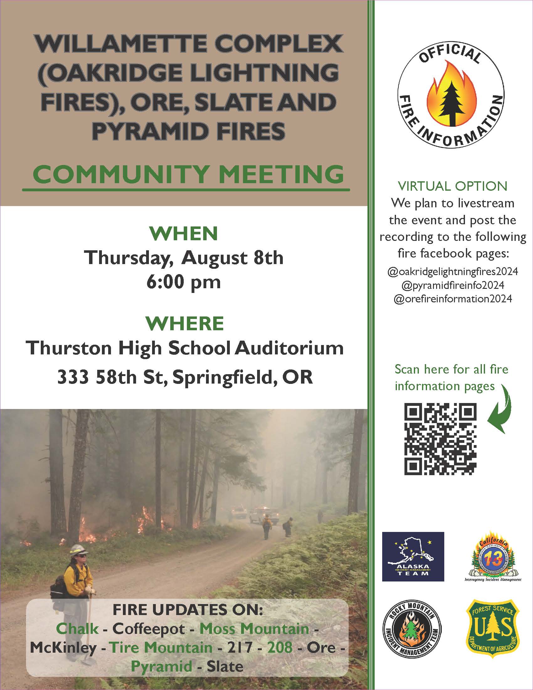
Community Meeting for Public Meeting Thursday 08 08 2024
Related Incident: Willamette Complex Fires - SouthOre FirePyramid and Slate Fires
Publication Type: Announcement
Community Meeting
WILLAMETTE COMPLEX, (OAKRIDGE LIGHTNING, FIRES), ORE, SLATE AND, PYRAMID FIRES
Thursday, August 8, 2024
6pm
Thurston High School Auditorium
333 58th St, Springfield, OR
VIRTUAL OPTION
We plan to livestream the event and post the recording to the following fire Facebook pages:
@oakridgelightningfires2024
@pyramidfireinfo2024
@orefireinformation2024
Settings - change map background and toggle additional layers
Filter - control incident types displayed on map.
Zoom to your location
Reset map zoom and position
Could not determine your location.
Show Legend
 Wildfire
 Prescribed Fire
 Burned Area
Response
Burned Area
Response Other
Other
Clair
Unit Information
Incident Contacts
Settings - change map background and toggle additional layers
Filter - control incident types displayed on map.
Zoom to your location
Reset map zoom and position
Could not determine your location.
Show Legend
- Wildfire
- Prescribed Fire
- Burned Area
Response
- Other
Bartlett
Unit Information
Incident Contacts
Settings - change map background and toggle additional layers
Filter - control incident types displayed on map.
Zoom to your location
Reset map zoom and position
Could not determine your location.
Show Legend
- Wildfire
- Prescribed Fire
- Burned Area
Response
- Other
Wally
Unit Information
Incident Contacts
Leeds Creek Fire Area Road and Trail Closure 08 06 2024
Related Incident:
Publication Type: Closures
Pursuant to 16 U.S.C. § 551 and 36 C.F.R. § 261.50 (a) and (b), the following are prohibited on the National Forest System (NFS) area, roads, and trails in the Pinedale and Wind River Ranger Districts, Bridger-Teton and Shoshone National Forests from August 5, 2024 - October 31, 2024.
Monday Evening Update for the Park Fire 08 05 2024
Related Incident: Park Fire
Publication Type: News
Park Fire Incident Update
Morning of Monday, August 5, 2024
For more information on the Park Fire, please visit: https://inciweb.wildfire.gov/incident-information/calnf-park-fire
Size: 406,579 acres with 34% containment; Personnel: 6,586
Lassen National Forest:
The Park Fire has burned 95,743 on the Lassen National Forest.
As expected, the #ParkFire became more active today as hotter and drier weather conditions persisted. Wind, terrain and dense dry fuels combined to push the fire up the Mill Creek drainage. The fire crossed Tamarack Road into the South Fork Antelope Creek drainage. Crews and aircraft worked aggressively to slow and contain the increased fire activity. With the increased fire activity, a mandatory evacuation order has been issued for 720-A in Tehama County.
CAL FIRE:
Today the Park Fire burned actively in heavy, receptive fuel beds, including abundant dead and down fuels in mature stands with more complete consumption in timber nursery stands, understory, and brush. Extremely low humidity was observed across the fire, dipping to 8% in the active portions of the fire. Daytime highs ranged from 102 degrees in the lower elevations to the mid-90s in the higher elevations. Skies were sunny and morning smoke lifted, allowing the inversion to break in Mill Creek around midday.
While there were evacuations lifted in both Tehama and Butte Counties, there was one zone that was upgraded to an Evacuation Order west of the intersection of Highways 32 and 36 in Tehama County.
High temperatures will persist through the week, reaching to between 90-100 degrees through mid-week. However, by the weekend, there may be a slight cooling trend and uptick in humidity.
The Butte County Local Assistance Center opened at 9AM today and will be available for two weeks. 2156 Pillsbury Road Suite 100 Chico, CA 95926
For more information on the Park Fire please visit:
- CALFIRE Park Fire: https://www.fire.ca.gov/incidents/2024/7/24/park-fire
- Butte County Sheriff: https://www.facebook.com/bcsonews
- CAL FIRE Tehama-Glenn Unit/ Tehama County Fire Dept: https://www.facebook.com/CALFIRETGU
- CAL FIRE Shasta-Trinity Unit/Shasta County Fire Department: https://www.facebook.com/CALFIRESHU
- Butte County, CA: https://www.facebook.com/ButteCounty
Swawilla I Bridge Creek Fires Daily Update 08 05 2024
Related Incident: Bridge Creek
Publication Type: News
Update for Swawilla I and Bridge Creek Fires
EVACUATION LEVELS: The town of Keller, the Highway 21 corridor, Mt. Tolman, Buffalo Lake and McGinnis Lake are now in Level 2 evacuation.
ROADS: All roads in evacuation level 2 areas are open, including Hwy 21, Peter Dan/Manilla and Cache Creek.
The Keller Ferry is open and fully operational.
The Southern Area Blue Complex Incident Management Team assumed command of both fires at 6:00 this morning. The Blue Team would like to thank the Northern Rockies Team 6 for a smooth transition and the Colville Tribes for a warm welcome.
Swawilla I Fire
Firefighters will focus on improving containment lines and extinguishing hot spots on the northern section of the fire. A structure protection group will continue patrolling the fire line near Keller. Crews will continue extinguishing heat along control lines, mopping up around homes, and monitoring the fire perimeter on the entirety of the Swawilla I Fire.
Bridge Creek Fire
The fire is 100 percent contained. Suppression repair, including seeding and erosion control, will continue over the next few days. Once suppression repair is complete, Bridge Creek Fire suppression repair resources will be reassigned to the Swawilla I Fire.
Fire Weather
Hot and dry weather is expected to persist through Tuesday. The remainder of the week will see temperatures top out in the mid-80s and relative humidity ranging from 20 to 25 percent.
Safety Message
Due to the unstable weather system moving through the area, smoke should lift into the atmosphere relatively quickly. However, remaining pockets of unburned fuels in the interior of the fire will continue to ignite resulting in continued smoke in the area over the next several days. The persistent smoke may be unhealthy for sensitive groups. Visit airnow.govfor air quality in your area and take precautions for protecting your health.
Please slow down when driving all roads leading to and from the fires. There is a considerable amount of firefighting traffic and slow-moving equipment along roads and the potential for poor visibility due to lingering smoke.
No drones are allowed within our Temporary Flight Restrictions (TFR). Remember, if you fly, we can’t!
Additional Information and Maps at https://inciweb.wildfire.gov/
https://www.facebook.com/CCTENV, https://www.facebook.com/CCTBroadcasts
Airnow.gov