
Settings - change map background and toggle additional layers
Filter - control incident types displayed on map.
Zoom to your location
Reset map zoom and position
Could not determine your location.
Show Legend
 Wildfire
 Prescribed Fire
 Burned Area
Response
Burned Area
Response Other
Other
Crozier Fire
Unit Information
Incident Contacts
Snag Fire Alert Warm Lake Highway Closure Likely 08 10 2024
Related Incident:
Publication Type: News
Alert: Anyone who remains in the Warm Lake area should be prepared for a full closure of the Warm Lake Highway and have enough fuel to exit the area to the south via the Deadwood area towards Highway 21 or to the north via Lick Creek Road towards McCall.
Ingress along the Warm Lake Highway on the east side of Scott Valley is closed. Currently, westbound traffic toward Cascade along the Warm Lake Highway is allowed. Residents and recreators in the area will be notified of the closure. Residents not currently at their homes will be granted one-time access into the Warm Lake area to retrieve animals and other property if they can provide a valid address.
As a reminder, the South Fork Road remains closed due to construction unrelated to the Snag Fire.
Crazy Creek Fire Daily Update for August 10 2024 08 10 2024
Related Incident: Crazy Creek
Publication Type: News
Crazy Creek Fire containment grows;
incident management transferred to California Incident Management Team 1
Daily Update August 10, 2024
Fire Information Phone: 541-208-1768 (8 a.m.-8 p.m.)
Email: 2024.crazycreek@firenet.gov
Acres*: Crazy Creek – 81,085, 60% contained
Kitty Creek – 73, 100% contained
*Acreage changes may occur due to overnight operations and infrared mapping.
Location: Crazy Creek: 5 miles north of Paulina, Oregon; 498/Kitty Creek: 7 miles south of Mitchell, Oregon
Start Date: July 22, 2024 Personnel: 629
Resources: 14 crews | 1 helicopter | 24 engines | 11 bulldozers | 16 water tenders | 3 masticators | 27 skid steers
Highlights: Containment of the Crazy Creek Fire grew to 60 percent, from 50 percent reported Friday, Aug. 9. California Incident Management Team 1 assumed command of the fire at 6 a.m. today.
Firefighters on the southern and western portions of the fire worked to strengthen containment lines by extinguishing pockets of residual heat and adding depth to the containment line by burning vegetation from the containment line back toward the fire. Available crews and resources were shifted to assist firefighters on the northeast portion of the fire, particularly to bolster containment lines in the Bear Mountain and East Wolf Creek areas. Crews completed protection perimeters around recreation structures located along Forest Road 5820 at the eastern perimeter of the fire.
Evacuations: Evacuation orders remain in effect for areas in Crook and Wheeler Counties for areas in or near the fire. Level 3 evacuations have extended from the Forest Boundary to Highway 380. Level 2 evacuations have extended south of Highway 380. For further information, please refer to the Crook County Office of Emergency Management evacuation map.
Weather: Hot, dry weather continues through the weekend across the region with temperatures in the high 80s to low 90s, light wind and low humidity.
Importance of Fire Prevention: All public lands in Central Oregon, to include the Ochoco National Forest, are in Stage 2 Public Use (Fire) Restrictions. All open flames, including woodstoves and charcoal briquette fires, are prohibited. In times of high fire danger, it is crucial for everyone to follow fire prevention measures to avoid additional strain on overburdened resources. The public's cooperation in adhering to fire bans and restrictions is vital to prevent new fires from starting and to help our firefighters focus on containing the existing fires. Learn more at https://www.fs.usda.gov/alerts/ochoco/alerts-notices/?aid=89068.
Fire Restrictions and Closures: The Ochoco National Forest has implemented a forest closure for the Paulina Ranger District. More information can be found at fs.usda.gov/alerts/ochoco/alerts-notices/?aid=89203. Bureau of Land Management has issued a temporary closure for public lands in Crook and Grant Counties. More information is available at https://www.blm.gov/sites/default/files/docs/2024-08/orwa-fpo-pri-paulina080224.pdf.
More Information:
- InciWeb: https://inciweb.wildfire.gov/incident-information/orocf-crazy-creek
- Facebook: Facebook.com/Crazy Creek Fire
- Central Oregon Wildfire Information: https://centraloregonfire.org/
- Crook County Emergency Information Map: https://arcg.is/1ij0vb
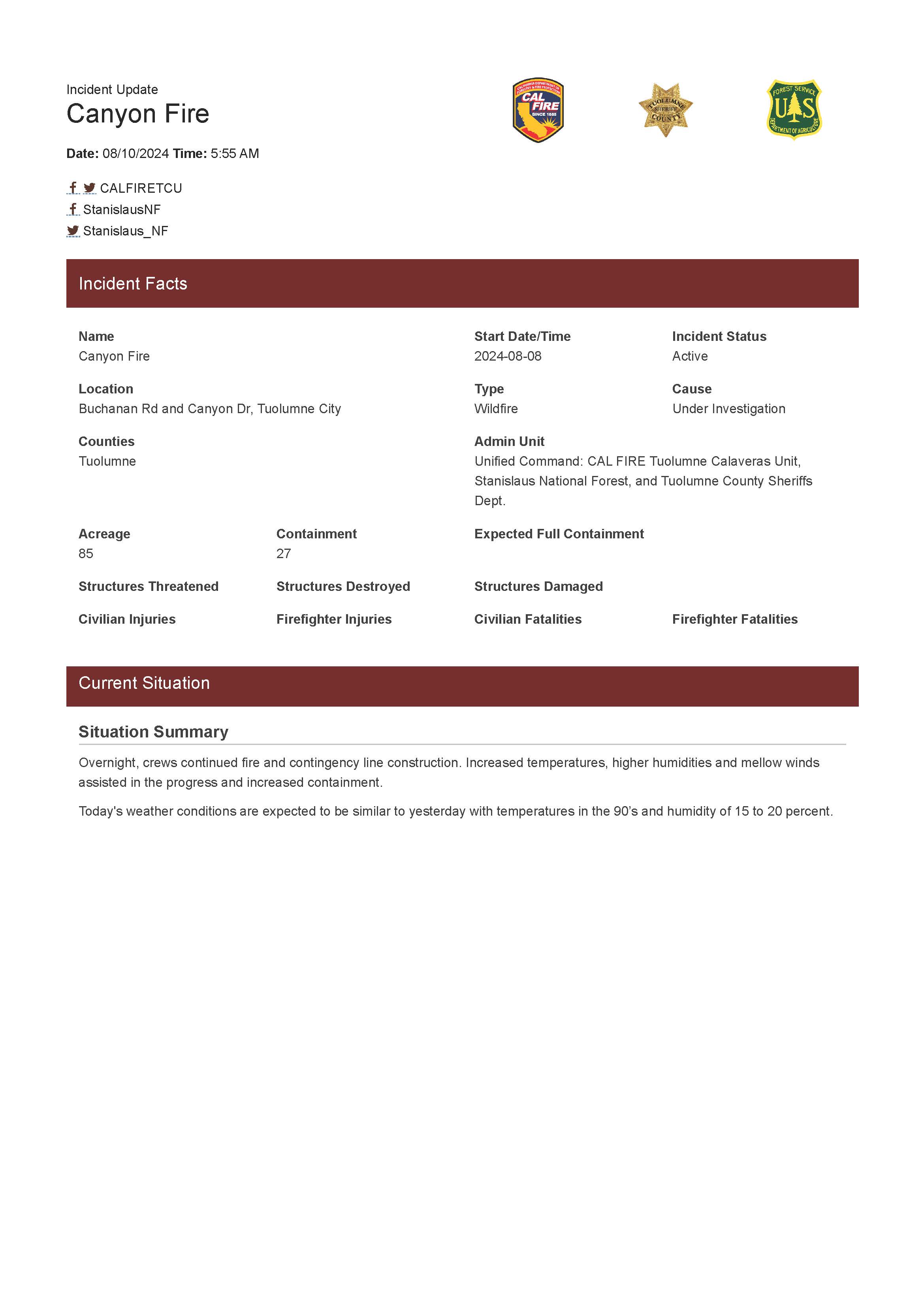
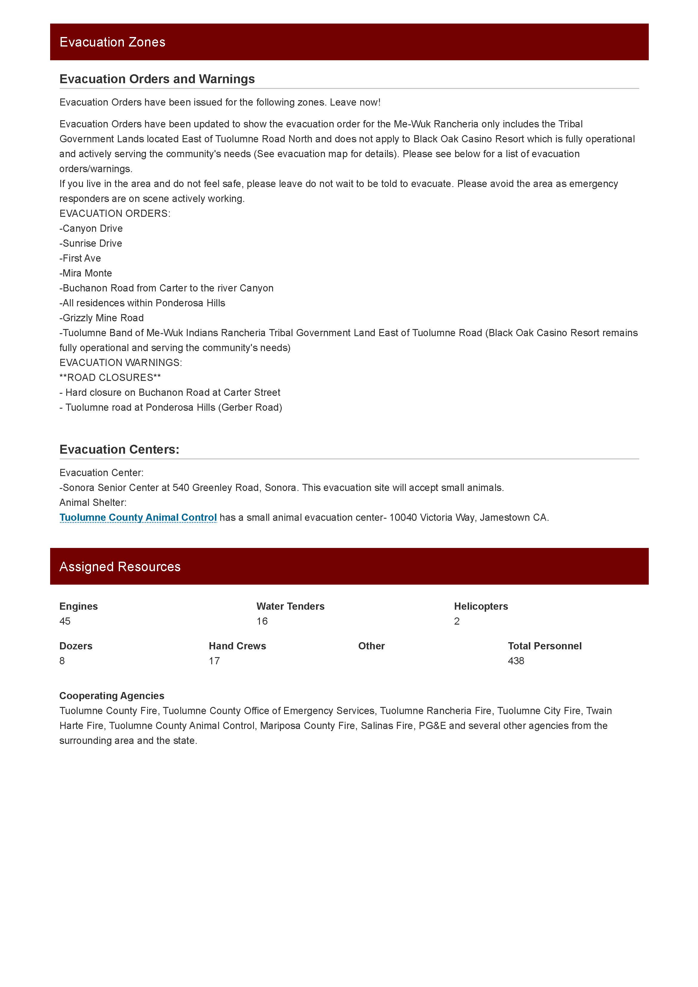
Canyon Fire Update 08 10 2024
Related Incident: Canyon Fire
Publication Type: News
Crews worked overnight to enhance containment lines and ensure the fire remained within the 85-acre footprint. Today crews will patrol the firelines and improve them where needed. Mop-up (200 feet of black adjacent to the containment line) and rehab of dozer lines also began today.
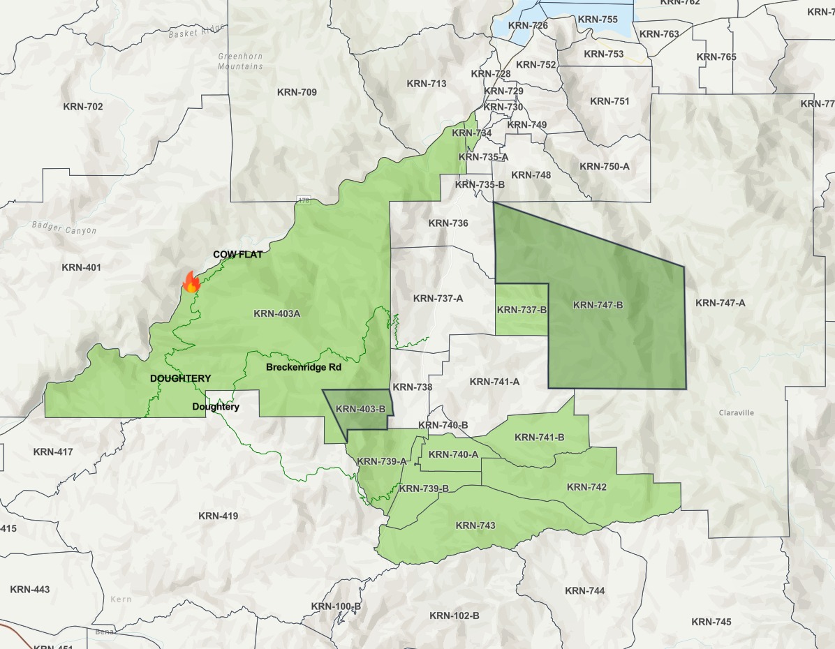
Borel Fire Evacuation Update 08 10 2024
Related Incident: Borel Fire
Publication Type: Announcement
This is a message from the Kern County Fire Department
Haga clic aqui para Espanol: https://ahas1.com?es5616
For ASL interpretation follow the link: https://ahas1.com?5616
This is an update to the Borel Fire
The evacuation orders for Zones KRN-403-B and KRN-747-B have been LIFTED. There are no further advisories in place at this time.
Click on the link below for health and safety information for safely returning home: https://kernpublichealth.com/returning-home-after-a.../
Follow the link to view the updated map: https://go.genasys.com/pzhl3
If you have an emergency, call 9-1-1.
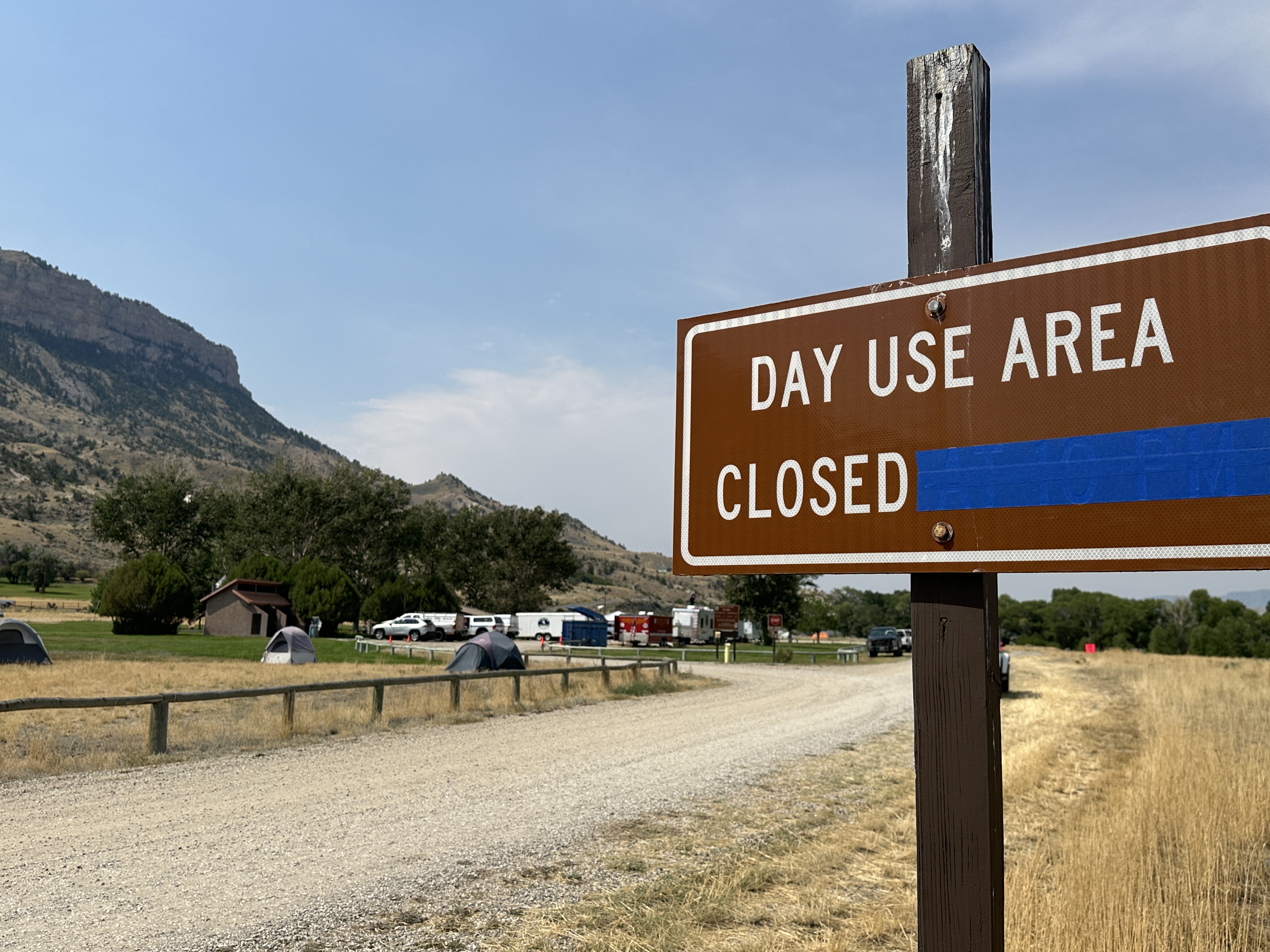
Clearwater Fire Incident Command Post 08 10 2024
Related Incident:
Publication Type: News
The Clearwater Fire has set up an Incident Command Post (ICP) at the day use area at Buffalo Bill State Park North Fork Campground. As a result, the day use area is currently temporarily closed for public use. However, the remainder of the campground is open to the public.
How do administrators choose an Incident Command Post location? Much of that depends on the size and scope of the fire. Some factors considered include immediate available space adequate for quick setting up a “temporary city,” a safe location from fire activity so the base camp won’t need to be relocated if fire activity picks up, drive time and traffic patterns for crews to get to the fire area, and a quiet space for firefighters to sleep and recover.
The Bill Cody State Park graciously offered the use of the day use camping area which met the criteria for the Clearwater Fire. Prior to crews arriving at ICP, and before driving to the fire, vehicles have undercarriage washing to prevent the spread of weeds. Following check in, all personnel are briefed on the area food storage orders, grounds sanitation efforts, and other ICP guidelines. The Clearwater Team is grateful for the hospitality from the Buffalo Bill State Park crew and generosity of the use of campground facilities.
Click here to see a photo of the day use area with part of the fire camp in the background.
All closures lifted on Badland Complex 08 10 2024
Related Incident: Badland Complex 2024
Publication Type: Announcement
All closures associated with the Badland Complex have been lifted. Baker County Sheriff's Office has reopened Snake River Road. All BLM recreation sites are open, including Spring Rec, Swede's Landing and Bassar Diggins campgrounds.
All evacuation orders lifted on Badland Complex 08 10 2024
Related Incident: Badland Complex 2024
Publication Type: Announcement
Baker County Sheriff's Office has lifted all evacuations associated with the Badland Complex Fires.
All closures lifted on Badland Complex 08 10 2024
Related Incident: Badland Complex 2024
Publication Type: Closures
All closures have been lifted on the Badland Complex. Baker County Sheriff's Office has reopened Snake River Road. All BLM recreation sites are open, including Spring Rec, Swede's Landing and Bassar Diggins campgrounds.