
Daily Update on Clearwater Fire for Sunday 08 11 2024
Related Incident:
Publication Type: News
Fire Location: 11 miles west of Wapiti, WY
Size: 1,896 acres
Containment: 43%
Personnel: 142
Start Date: 7/19/24
Cause: Lightning
Incident Commander (IC): Ron Steffens, Wyoming Type 3 Team
Operations
Much of yesterday’s work focused in the Elk Fork Campground area, where crews cut burned trees that could be a safety hazard when the campground eventually reopens. Crews also cleared brush and other debris and improved handline south into the Elk Fork drainage. The incident management team continues seeking opportunities to minimize spread on the fire’s southern perimeter.
Due to heavy fuels in steep, inaccessible terrain, the fire is likely to burn and smolder for some time in conifer forest, brush, and dead and down logs even if cooler temperatures and precipitation prevail.
Closures
Elk Fork Campground is closed indefinitely; Wapiti Campground and Clearwater Campground are closed until fire conditions allow otherwise. A road and trail closure are in effect at NFS Road #424, Elk Fork Road and NFS Trail # 760, Elk Fork Trail. Click here to view the closure order (#021404-24-03). For safety reasons, the public is asked to respect closed campgrounds and trails. A temporary flight restriction (TFR) is in effect until August 19, 2024.
Weather | Anticipated Fire Behavior
Today’s weather shows a chance of thunderstorms in the afternoon. Thunderstorms will create gusty and erratic winds which may create smoke dispersal in the area and winds may affect fire behavior and growth.
Safety Information
The Shoshone National Forest implemented Stage 1 fire restrictions due to very dry conditions of fuels and continued hot, dry weather. Click here to view a copy of Stage 1 Fire Restrictions order (#02-14-04-24-04).
A USFS law enforcement officer continues to monitor traffic on Highway 14 to ensure drivers are traveling at a safe speed and watching for fire crews working near or on the roadway.
Fire activity remains high throughout the western U.S. and Canada, resulting in widespread smoke. Use the Air Now link to check air quality conditions; click here to view an overview map of fire activity.
Photos
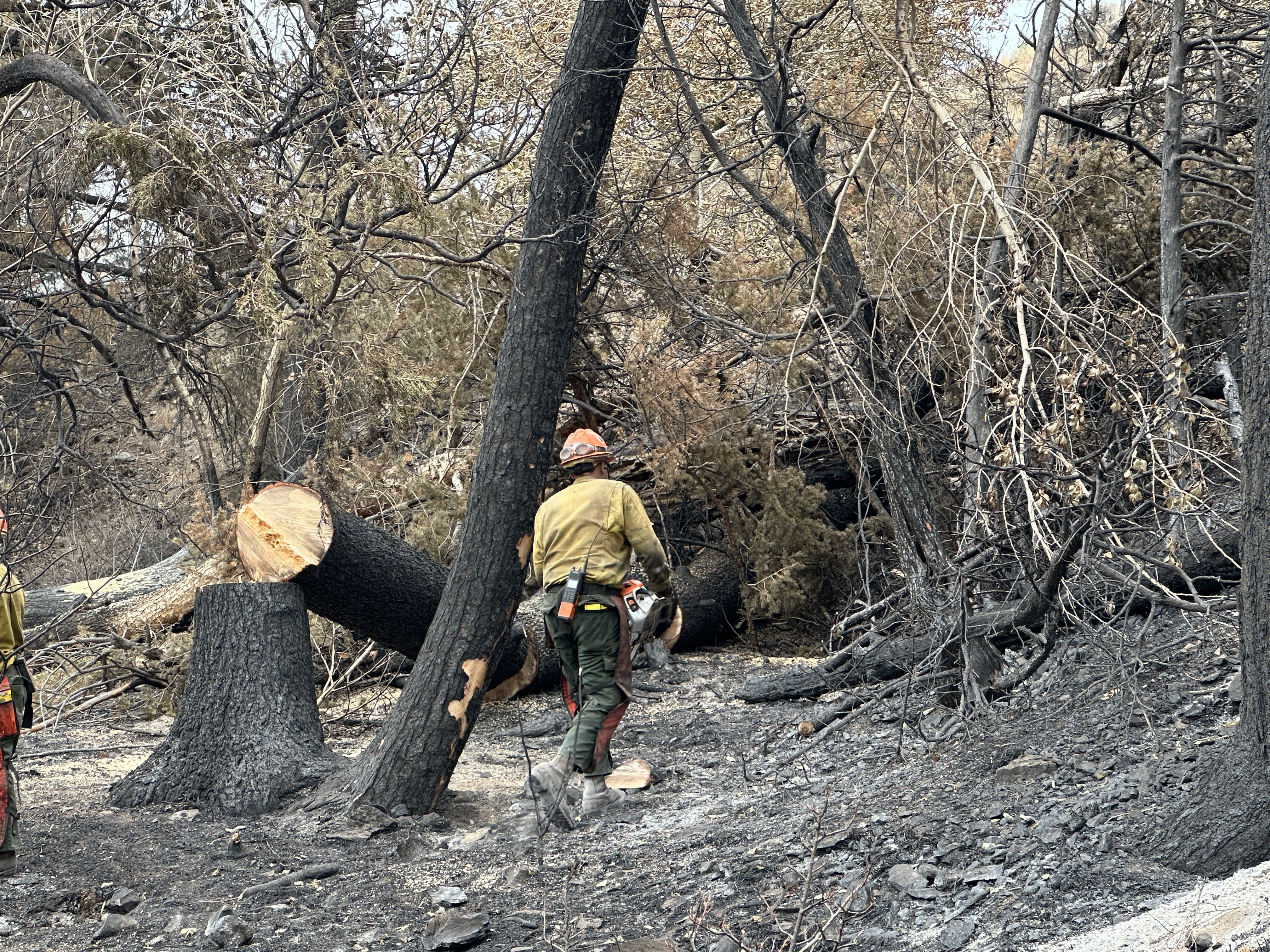
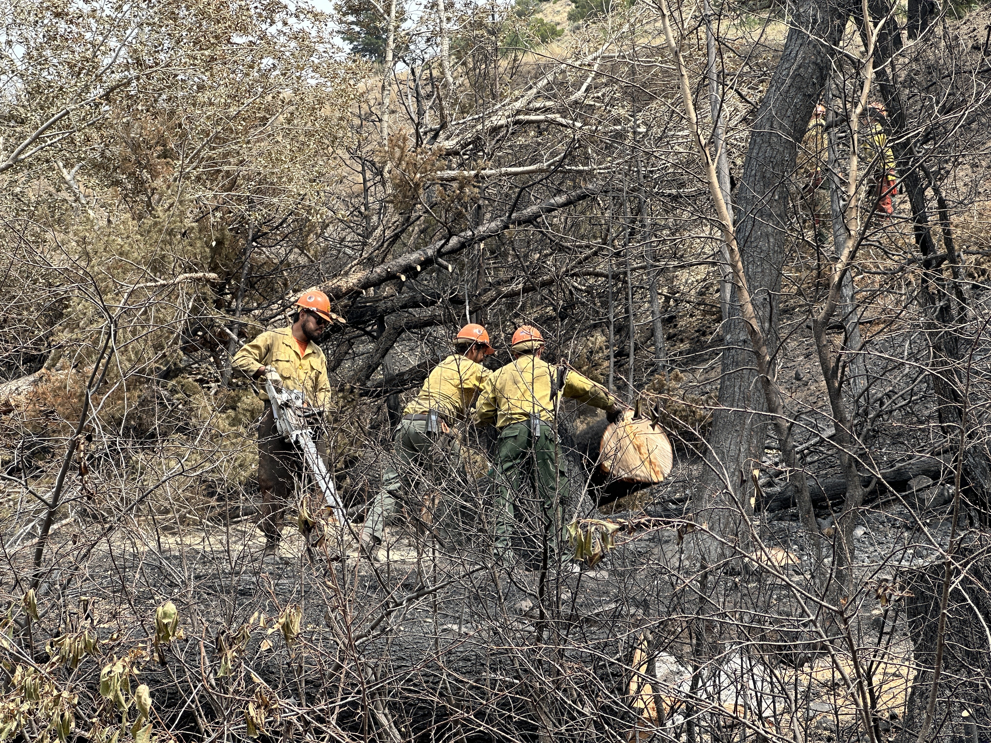
Below are links to several pictures of the Horseshoe Meadow crew working in the Elk Fork Campground on Saturday, August 10. (Note: Due to the size of the files, each picture may take a few seconds to load.)
- A member of the Horseshoe Meadow crews fells a burned tree in the Elk Fork Campground for safety mitigation
- A Horseshoe Meadow crew works on felling and moving burned trees in the Elk Fork Campground
WEST MOUNTAIN COMPLEX Snag and Dollar Fires Update 08 11 2024
Related Incident: Dollar Fire
Publication Type: News
Fire Location
- Dollar: 18 miles NE of Cascade, Idaho
- Snag: 11 miles E of Cascade, Idaho
Size
- Dollar: 1,377 acres
- Snag: 10,571 acres
Containment
- Dollar: 0%
- Snag: 0%
Personnel
- Dollar: 0
- Snag: 21
Start Date
- Both Fires: 8/5/2024
Cause
- Both Fires: lightning
Incident Commander
Tony DeMasters, Great Basin Complex Incident Management Team #2
---
Snag Fire: https://inciweb.wildfire.gov/incident-information/idbof-snag-fire
Last night, firefighters patrolled the Warm Lake Highway to monitor fire behavior. In the Warm Lake residential area, firefighters worked to stage equipment, such as water pumps and hose, if needed for future structure protection actions. A confinement strategy is underway to create a containment boundary around the southern fire perimeter to protect the resources around Horsethief. Indirect line to the south will be utilized to further this containment boundary. Fire movement continues in all directions, with the biggest growth occurring in the northeast corner. Incident responder and public safety remain the highest priority while also protecting energized power lines along the Warm Lake Highway leading to Yellow Pine, private structures, and the Warm Lake Highway itself.
Dollar Fire: https://inciweb.wildfire.gov/incident-information/idbof-dollar-fire
The Dollar Fire saw minimal growth yesterday. The fire line reached an old burn scar to the top of the eastern ridgeline, and the fire is expected to burn itself out in that area. Firefighters are keeping an eye on the fire’s movement towards the Dollar Trailhead and a nearby drainage.
SNAG FIRE EVACUATION INFORMATION
The Valley County Sheriff’s Office issued a “ready” evacuation order for Warm Lake residents and the North Shore Lodge at Warm Lake on August 7th. This map can be found on Inciweb: https://tinyurl.com/42auxnk8. A second “ready” evacuation order was issued on August 8th for the Horsethief area, including the YMCA Camp, and areas of Scott Valley. This map can also be found on Inciweb, with the relevant areas outlined in purple: https://tinyurl.com/4vfj657x.
Ingress along the Warm Lake Highway on the east side of Scott Valley is closed. Currently, westbound traffic toward Cascade along the Warm Lake Highway is allowed. Residents and recreators in the area will be notified of the closure. Residents not currently at their homes will be granted one-time access into the Warm Lake area to retrieve animals and other property if they can provide a valid address. Anyone who remains in the area should be prepared for a full closure of the Warm Lake Highway and have enough fuel to exit the area via the Deadwood area or Lick Creek Road. As a reminder, the South Fork Road remains closed due to construction unrelated to the Snag Fire.
Review the READY, SET, GO evacuation procedure for Valley County: https://www.co.valley.id.us/ReadySetGo
For timely information on evacuations, check out your county’s emergency alert system.
- Valley County: https://www.co.valley.id.us/CompleteEmergencyNotificationandAlerting
- Adams County: https://public.alertsense.com/SignUp/PublicUser.aspx?regionid=1077
FOREST CLOSURES
Snag Fire Closures: The Boise National Forest has issued closure order # 0402-04-100 for the National Forest System (NFS) roads, trails, and lands around the Snag Fire.
For maps and more detailed descriptions of the closures on the Payette National Forest, please visit: https://www.fs.usda.gov/alerts/payette/alerts-notices
For maps and more detailed descriptions of the closures on the Boise National Forest, please visit: https://www.fs.usda.gov/alerts/boise/alerts-notices
Fire Restrictions: Stage 1 Fire Restrictions have been issued for the Payette Fire Restrictions Area on the Payette National Forest and the West Central Mountains Fire Restrictions Area on the Boise National Forest. For more information on the restrictions and a very helpful interactive map, visit https://www.idl.idaho.gov/fire-management/fire-restrictions-finder/
Important Links
- Payette National Forest: https://www.fs.usda.gov/payette
- Payette National Forest Facebook: https://www.facebook.com/PayetteNationalForest
- Boise National Forest: https://www.fs.usda.gov/boise
- Boise National Forest Facebook: https://www.facebook.com/BoiseNationalForest
- Idaho Department of Lands: https://www.idl.idaho.gov/fire-management/
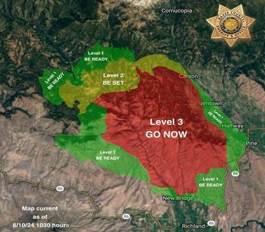
Evacuations Update for Town Gulch Fire Baker County Sheriffs Office 08 10 2024
Related Incident: Town Gulch
Publication Type: Announcement
Level 3 (GO NOW): The area South of FS Road 7735, 77 road to where it crosses Summit Creek then south of Carson Creek to the Pine Valley floor. The area west of Carson Creek from West Carson Road to Valley View Lane, sest of Mining Channel ditch from Valley View Lane to Jackson Lane, west of Foothill Ditch from Jackson Lane to the ODF Boundary Line, then west of the ODF boundary line to Highway 86. The area North of the ODF Boundary from Highway 86 to the 77 Road to Immigrant Gulch, north of where the Brooks Ditch crosses the Eagle Valley Rural Fire Protection District Boundary to Summit Creek where it meets Summit Creek Road, north of Summit Creek Road to Eagle Creek Road, then north of the Idaho Power line from Eagle Creek Road to Sparta Lane. The area east of Sparta Lane from the Idaho Power Line to Mitchell Road. East of Mitchell Road to Eagle Creek. Then east of 7737 to the 7737 and 7735 intersection.
Level 2 (BE SET): North of Shanghai Creek on the west side of the fire and then north of Carson creek on the east side of the fire. The area east of the headwaters of Puzzle Creek to Dempsey Creek, then east of Paddy Creek. The area south of the FS Road 7725/77 intersection to Fuller Creek. The area west of Cornucopia Highway between Fuller Creek and West Carson Lane.
Level 1 (BE READY): West of the Cornucopia Highway starting near the intersection of the Cornucopia Highway and Allstead Lane all the way to Highway 86. West of Highway 86 to Immigrant Gulch. North of the intersection of Immigrant Gulch and Highway 86. North of the rock pit and the Tobin Ditch to Carnahan Lane. North of Sparta Lane from Old Foothill Road to the intersection of Sparta Lane and the Idaho Power line. From this intersection, the boundary becomes the Idaho Power Line to Thorn Gulch over to Gem Mine Road. East of Sparta Butte Road, FS Road 7005 to Forshey Meadow and then east of the FS Road 70 to the FS Road 7015. South of Empire Gulch on the west side of the fire and the intersection of Allstead Road and the Cornucopia Highway on the east side of the fire.
Basin PostFire BAER Assessment Report Summary Released 08 11 2024
Related Incident: Basin Post-Fire BAER
Publication Type: News
FOREST SERVICE: BASIN POST-FIRE BAER ASSESSMENT REPORT SUMMARY RELEASED
The Forest Service—Sierra National Forest completed a BAER post-fire assessment of the Basin Post-Fire burned area and affected watersheds to determine their response, soil conditions, potential threats, and recommended BAER emergency stabilization measures and actions on National Forest System (NFS) lands. BAER emergency treatments and activities are designed to decreased possible impacts to critical values from the burned areas during rainstorm events such as: life and safety, property, critical natural resources, and cultural resources.
NOTE: Attached below as “Related Information” is a PDF document called “Basin Post-Fire BAER Assessment Report Summary_PUBLIC”.
BAER SAFETY MESSAGE: Everyone near and downstream from the burned areas should remain alert and stay updated on weather conditions that may result in heavy rains and increased water runoff. Flash flooding may occur quickly during heavy rain events--be prepared to act. Current weather and emergency notifications can be found at the National Weather Service website: www.weather.gov/hnx/.
Canyon Fire Evening Update for 8102024 08 11 2024
Related Incident: Canyon Fire
Publication Type: News
Firefighters spent the day validating handlines and widening those needing additional work. Hose lays are also in place all around the perimeter of the fire. Crews began mopping up today, cooling hot spots and smoldering areas within 200 feet of the containment lines. In addition, suppression repair started today.
The steep terrain within the Tuolumne River Canyon continues to be the most difficult challenge for firefighters.
Fire behavior continues to be low to moderate, with a slow rate of spread. The weather was hot and dry again today, but is expected to cool tomorrow. Winds were generally light throughout the day, gusting to 14 mph in the late afternoon.
All Evacuation Warnings were lifted at 1800 today.
.jpg?VersionId=JTrkXu7rcPX1YEN.GqQJQlb7gPWVozW.)
Hunting and Fire Danger in Oregon 08 11 2024
Related Incident: Falls FireTelephone Fire
Publication Type: News
Hunting and Fire Danger in Oregon - Oregon Department of Fish and Wildlife (ODFW)
Hunters, anglers, wildlife watchers: What to know about wildfires. Wildfire season is hitting Oregon hard. Here's what hunters and anglers should know:
"As early season hunters know, dry conditions and the associated wildfire danger can have a large impact on your hunting opportunity. Check below for resources for finding fire closures and restrictions, and for ODFW's policy on tag refunds and restoration of preference points."
You can check for the latest fire updates and closures using the links on the ODFW webpage. This page will also describe ODFW policies on refunding tags and reinstating preference points. Also check out the ODFW Facebook Page.
CLOSURES and ACCESS:
ODFW does not close hunting seasons due to fire danger. But hunters may face access restrictions as areas close due to active fires, firefighting activity or fire danger. Know before you go – use these links to check for closures beforehand.
* National Forests in Oregon (U.S. Forest Service)
* Oregon Department of Forestry fire restrictions
* Private forestland closure information
A&H properties in NE Oregon remain closed indefinitely due to significant fire danger.
_____
Stay safe and informed, and thank you for your continued support.
Fire Information Line: 541-208-4370, staffed 8 a.m. to 8 p.m.
Email: 2024.Falls@firenet.gov
Falls and Telephone Fires Facebook Page
#fallsfire2024
#TelephoneFire2024
#Oregonwildfires2024
Saturday Evening Update for the Park Fire 08 10 2024
Related Incident: Park Fire
Publication Type: News
Park Fire Incident Update Evening of Saturday, August 10, 2024
For more information on the Park Fire, please visit: https://inciweb.wildfire.gov/incident-information/calnf-park-fire
Size: 429,135 acres with 37% containment | Personnel: 6,067
Lassen National Forest:
Today, on the #ParkFire, firefighters held the fire within the planning area through use of aircraft and direct line construction specifically in the area of Turner Mountain, while firefighters continue to mop-up and secure control lines around the fire's perimeter. Crews have used infrared capabilities provided by Unmanned Aircraft Systems (UAS) to locate areas of heat within and along the fire's edge. Lower temperatures and higher humidity aided in the fire fight throughout the day.
Tonight, ground crews will find and extinguish hot spots along the perimeter and aggressively build direct line on any new growth with support from night-capable aircraft. The collaborative, risk-informed strategies, and tactics from all our partners are being implemented under unified authority.
The #ParkFire has burned 113,600 acres on the Lassen National Forest.
CAL FIRE:
Fire suppression repair efforts continue on many parts of the fire, including mop-up and patrol. Diligent effort is being made by firefighters to mitigate spot fires surrounding the perimeter as some spot fires have been present.
In the northeast section of the fire, firefighters are going direct, and the fire is holding at the perimeter at this time. Interior islands and pockets of fuel continue to burn out. The fire is burning in heavy, receptive fuel beds composed of mature timber, dead and down fuels with the Mill Creek Plateau having significantly more brush than other areas.
The weather is expected to stay cooler than previous days and there should be some humidity recovery in the coming week. Tomorrow afternoon there could be some southwest wind gusts between 20 – 25 mph which could challenge fire suppression in those areas.
For more information on the Park Fire please visit:
- CALFIRE Park Fire: https://www.fire.ca.gov/incidents/2024/7/24/park-fire
- CAL FIRE Shasta-Trinity Unit/Shasta County Fire Department: https://www.facebook.com/CALFIRESHU
- CAL FIRE Tehama-Glenn Unit/ Tehama County Fire Dept: https://www.facebook.com/CALFIRETGU
- Butte County, CA: https://www.facebook.com/ButteCounty
- Butte County Sheriff: https://www.facebook.com/bcsonews
- Plumas County Sheriff: https://www.facebook.com/plumascountysheriff
- Shasta County Sheriff: https://www.facebook.com/ShastaSheriff
- Tehama County Sheriff: https://www.facebook.com/profile.php?id=100088640404140
Level 2 Evacuation Alert 882024 08 08 2024
Related Incident:
Publication Type: Announcement
On Wednesday, August 7th the Boise County Sheriff's Department issued a Level 1 "Get Ready" evacuation alert for the areas along Middlefork Road in Garden Valley. On Thursday, August 8th, the evacuation level was upgraded to Level 2 "Get Set" for the area along Middlefork Road just North of Stump Ranch Road to include Lightning Creek Road and Thunder Road areas. This alert is step one of three, Level 1 "Get Ready", Level 2 "Get Set", Level 3 "Go". Emergency vehicle traffic may be in the area attempting to contact property owners to cascade information.
An AlertSense (reverse 911) has been sent to residents within the mapped area. We encourage all County residents to subscribe to AlertSense. There is a link to AlertSense on the https://www.boisecounty.us/sheriffs-office/ to subscribe. Please do not call into Dispatch for directions on how to subscribe as dispatchers are fielding many calls at this time.