
Prescribed fire planned for March 20th 2021
Related Incident:
Publication Type: Announcement
Cancelled due to unfavorable conditions
The Hoosier National Forest is planning on conducting a prescribed fire today. A map of this location can be found attached to this announcement.
Wolf - 242 acres - Brown County, located off of Axsom Branch Road
Prescribed fire planned for March 9th 2021
Related Incident:
Publication Type: Announcement
The Hoosier National Forest is planning on conducting a prescribed fire today. A map of this location can be found attached to this announcement.
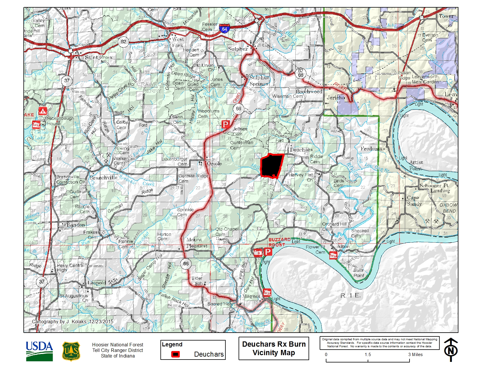
Deuchars - 348 acres - Crawford County. Located off of Deuchars Road.
Prescribed fire planned for March 8th 2021
Related Incident:
Publication Type: Announcement
The Hoosier National Forest is planning on conducting a prescribed fire today. A map of this location can be found attached to this announcement.
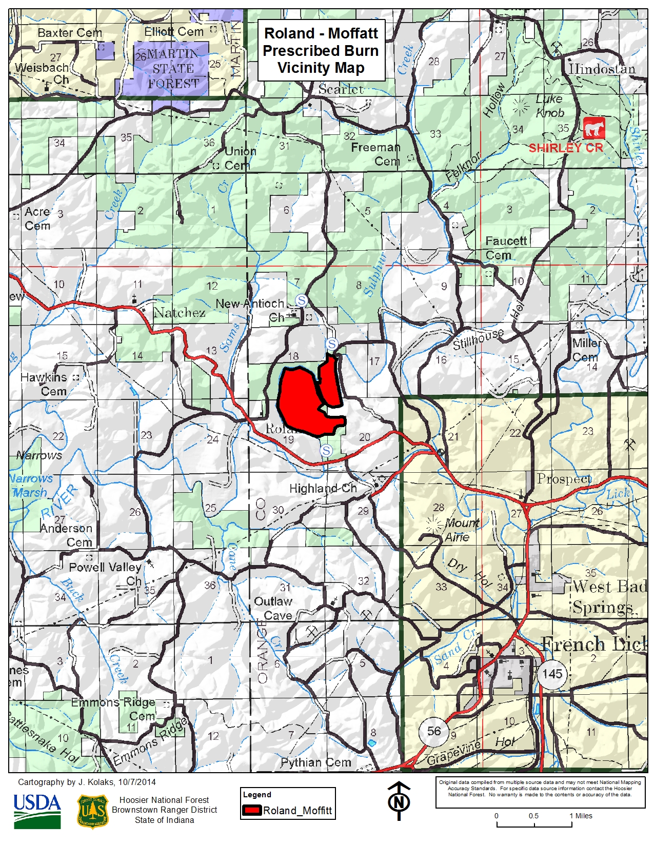
Rolland-Moffatt - 397 acres - Orange County. Located off of Rolland Road.
Prescribed fires planned for March 7th 2021
Related Incident:
Publication Type: Announcement
The Hoosier National Forest is planning on conducting 2 prescribed fires today. A map of these locations can be found attached to this announcement.
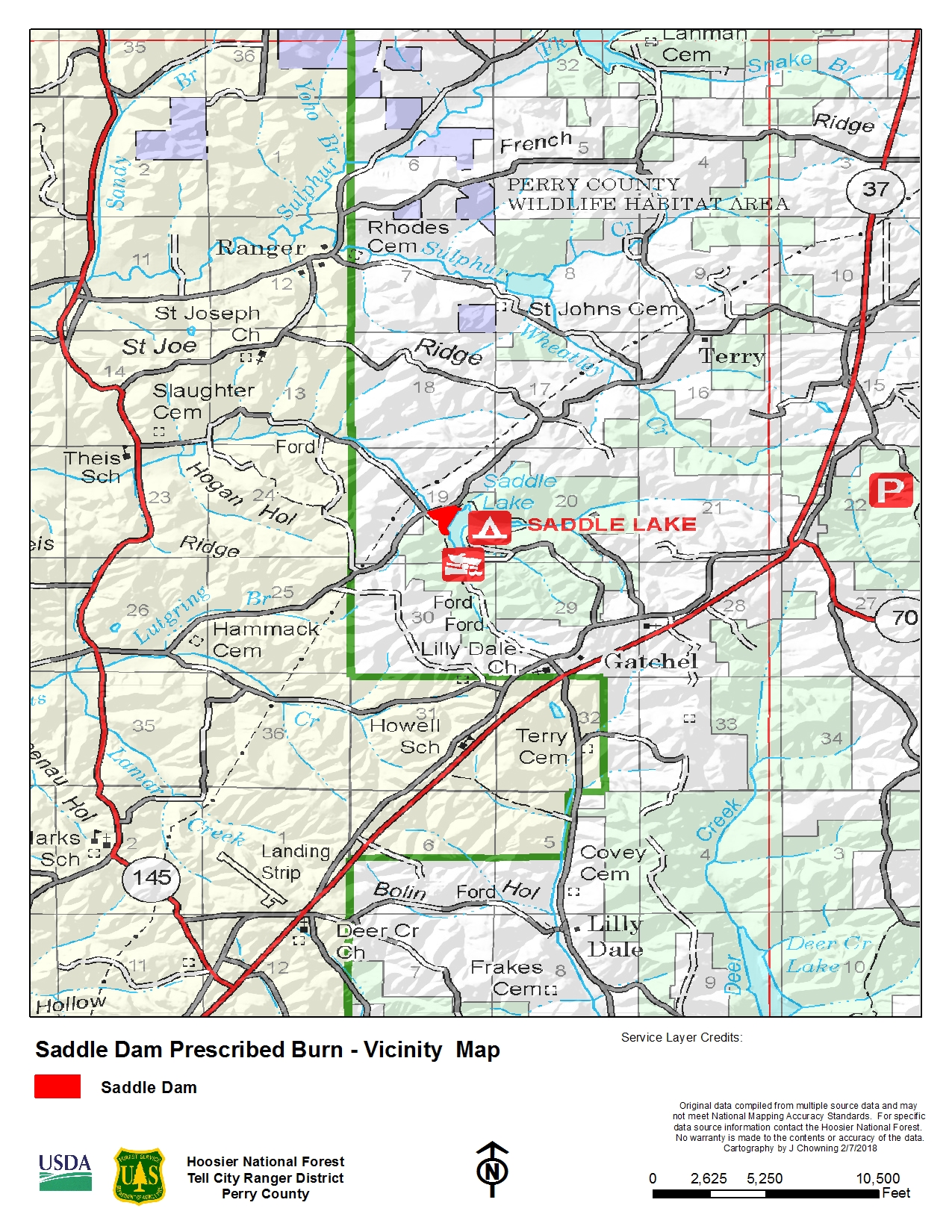
Saddle - 16 acres - Perry County. Located off of Locust Road.
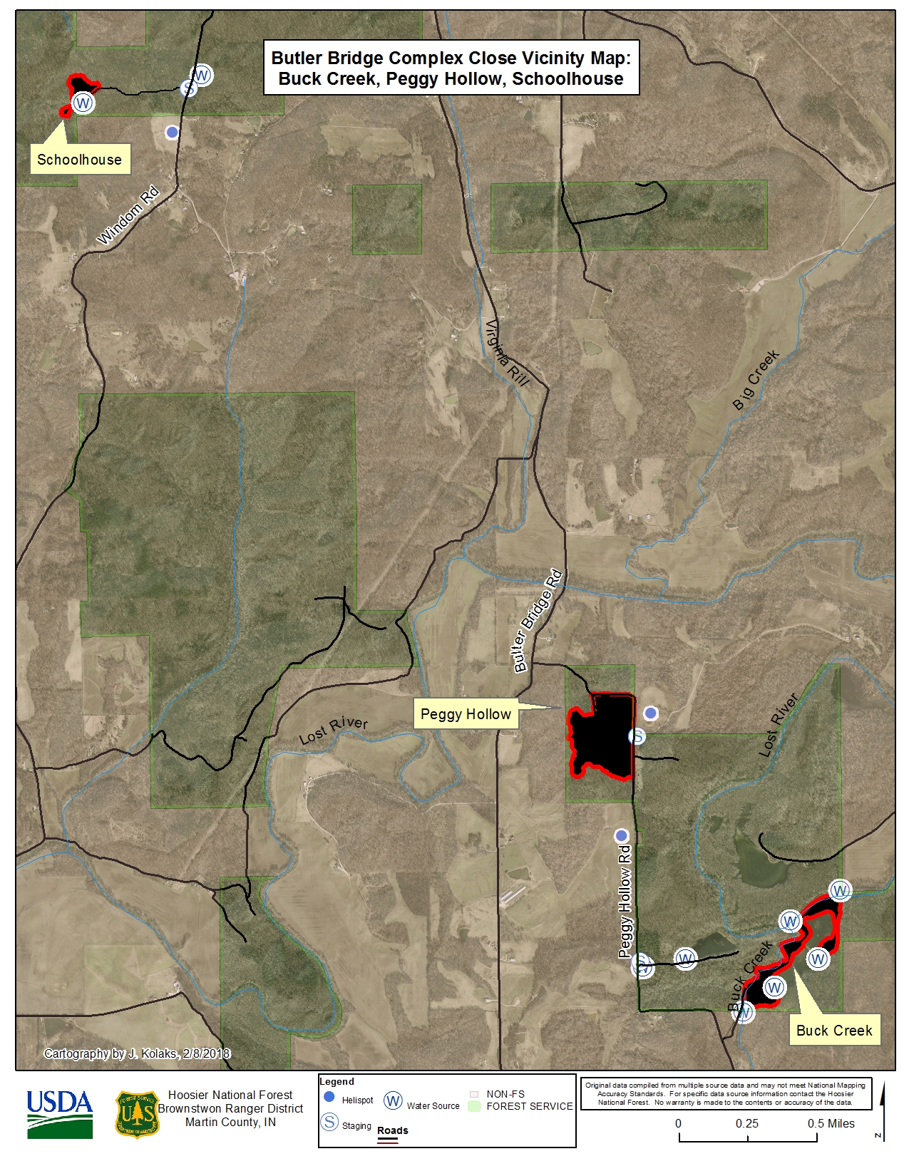
School House - 5 acres - Martin County. Located off of Windom Road.
Prescribed fire planned for March 6th 2021
Related Incident:
Publication Type: Announcement
The Hoosier National Forest is planning on conducting a prescribed fire today. A map of this location can be found attached to this announcement.
Blanton - 215 acres - Orange County - Located off of County Rd 500 near the Wesley Chapel Methodist Church.
Prescribed fires planned for March 5th 2021
Related Incident:
Publication Type: Announcement
The Hoosier National Forest is planning on conducting 2 prescribed fires today. A map of these locations can be found attached to this announcement.
Bottle - 40 acres - Orange County
Johnson Schoolhouse - 134 acres - Orange County
Hoosier National Forest to conduct Prescribed Burns
Related Incident:
Publication Type: News
Hoosier National Forest to conduct prescribed burns
Bedford, Indiana. March 4, 2021 —The U.S. Forest Service has begun to conduct seasonal prescribed burns to maintain, restore or improve early successional habitat, maintain wetlands, restore unique barrens ecosystems, and regenerate oak and hickory. Prescribed burns also improve soil health by recycling nutrients and reduce fuel loads, thereby lowering the risk of catastrophic wildfire.Approximately 5-6,000 acres are planned to receive prescribed burning in the spring of 2021 on National Forest System lands in the following counties: Brown, Crawford, Jackson, Martin, Monroe, Orange, and Perry.U.S. Forest Service fire managers utilize National Weather Service data to determine the best days to burn to achieve desired goals and to maximize safety. Many specific conditions must be met for a burn to occur, including fuel moisture, wind speed and direction, and relative humidity, among other factors. Decisions are generally made the day of the burn once parameters have been measured or forecasted. Therefore, advance specific notification for a particular burn can be difficult. Forest staff notifies the public in the immediate area of the prescribed burn. The public is advised to check the forest’s social media accounts for announcements of burns at www.facebook.com/HoosierNF/ and https://twitter.com/HoosierNF. Maps and additional details of the burn areas will be available at the following website: https://inciweb.nwcg.gov.All designated burn areas will not be accessible to the public on the day of the burn and for some time after the burn until the area is considered safe. If any hazards are identified within the burn area, the area may be inaccessible for several days for public safety. Burning may affect access to hunting areas. For your safety, please contact the Indiana Interagency Coordination Center dispatch (812-547-9262) if you plan to hunt or camp in or near prescribed burn areas.An unfortunate side effect of prescribed burning is smoke. Fire managers burn only under atmospheric conditions specified in a burn plan and rely on scientific data to choose days in which the impacts of smoke are minimized. Smoke plumes from a prescribed fire usually rise high into the air where the smoke dissipates. When smoke is present, motorists should reduce speeds and turn on headlights.All burns are done under carefully planned prescriptions and protocols to mitigate the risk of an escaped fire and smoke exposure to communities. All planned activities have been carefully coordinated with county emergency management agencies. Forest neighbors who wish to benotified of a specific date of a burn, or those who wish to report medical conditions that could be affected by smoke, may contact the Indiana Interagency Coordination Center Dispatcher at 812-547-9262.USDA is an equal opportunity provider, employer, and lender.
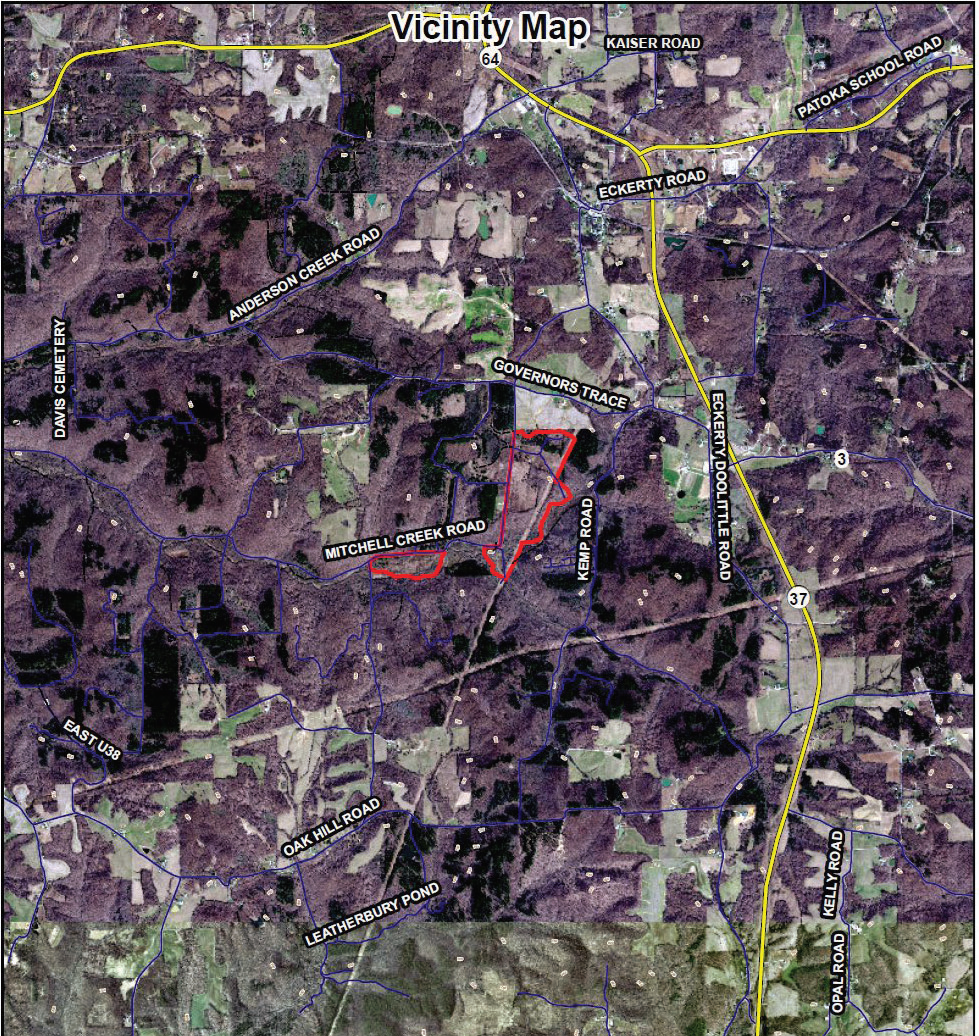
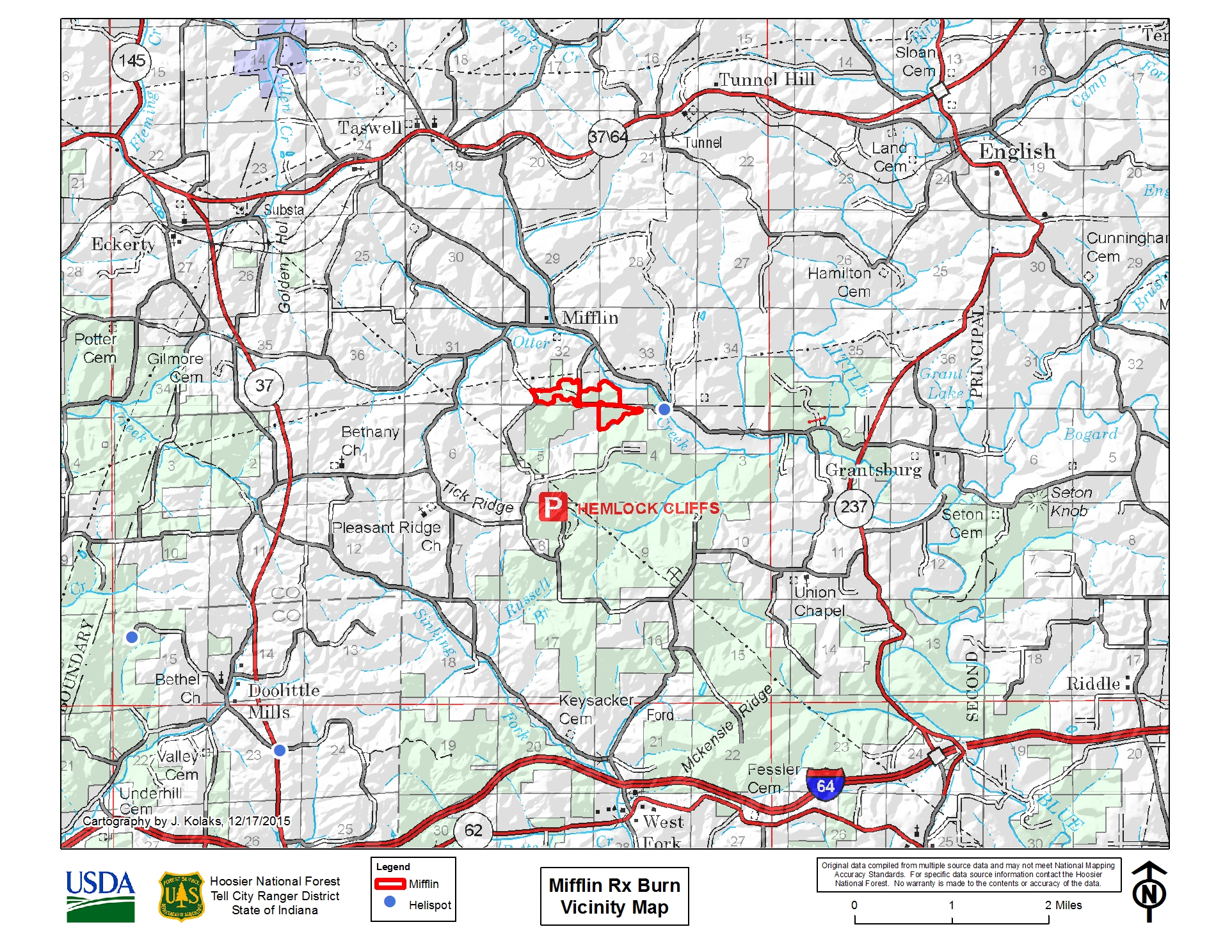
Prescribed fire planned for March 4th 2021
Related Incident:
Publication Type: Announcement
The Hoosier National Forest is planning on conducting a prescribed fire today. A map of this location can be found attached to this announcement.
Mifflin - 46 acres - Crawford County - North of Hemlock Cliffs, off Old Felker Road near Mifflin.
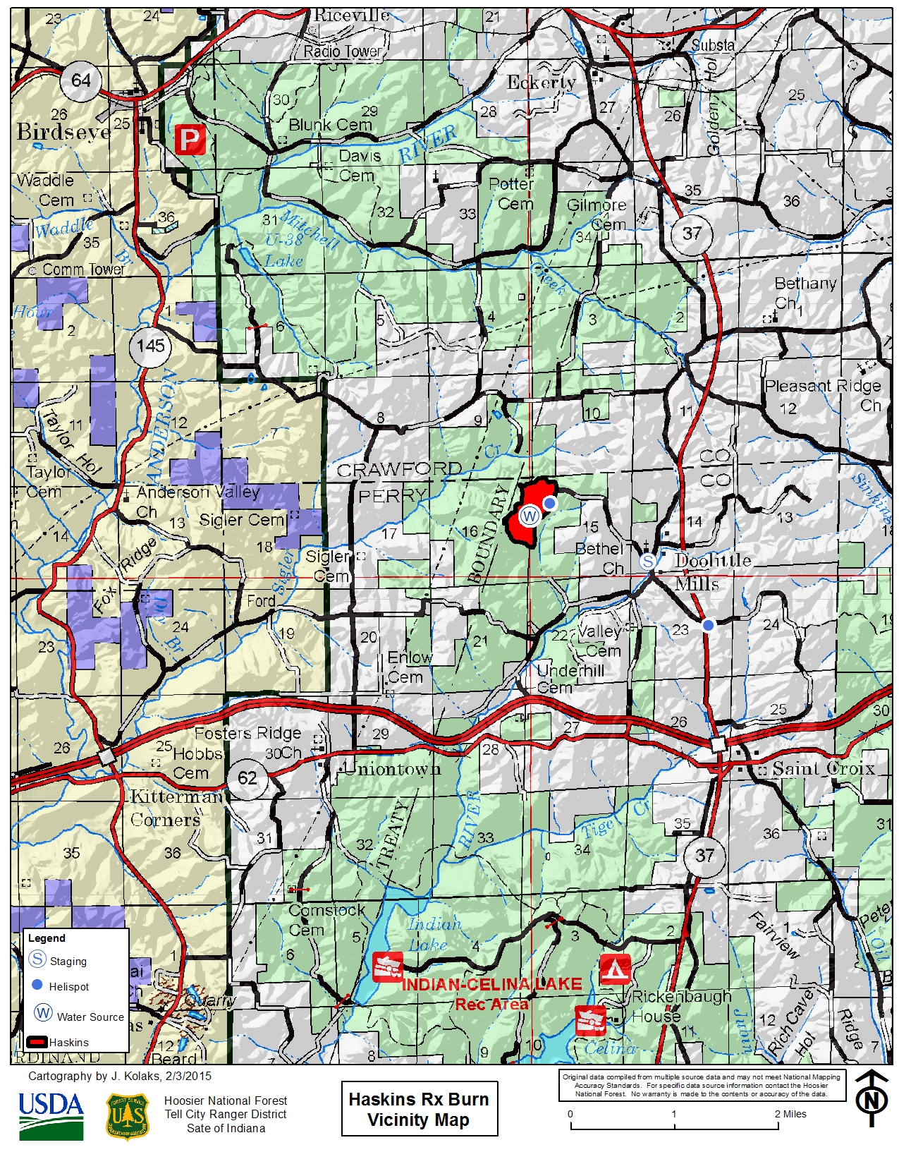
Prescribed fire planned for March 3rd 2021
Related Incident:
Publication Type: Announcement
The Hoosier National Forest is planning on conducting a prescribed fire today. A map of this location can be found attached to this announcement.
Haskins - 113 acres - Perry County, just south of Crawford County line. Located west of Doolittle Mills.
Cave Fire Update November 27 2019
Related Incident:
Publication Type: News
Cave Fire Update
November 27, 2019 9:30 a.m.
Cause: Unknown
Size: 4,330 acres
Containment: 20%
Personnel: 886
Injuries: 0
.
Road Closure and Evacuations: Hwy 154 remains closed. An update from the Santa Barbara County Sheriff’s office is expected today regarding road closures and evacuation areas. Visit www.ReadySBC.org for more information.
Current Fire Restrictions: The Los Padres National Forest currently does not allow open fires, wood or charcoal fires are prohibited in all areas of the forest, to include developed campgrounds. Additional Details are available on the Alerts and Notices page of the Los Padres National Forest Website.