
North Complex Fire AM Update 9132020
Related Incident:
Publication Type: News
North Zone:
Fire activity was calm last night with humidity increasing and smoke laying over the area. Firefighters will continue firing operations today while conditions allow in the Lookout Rock and Ontop Mine areas. Crews will continue to secure what was already fired, with the goal of meeting indirect bulldozer lines where the 2018 Camp Fire scar is located. Structure protection groups are in place surrounding the fire’s perimeter to protect nearby communities, taking extra care in getting through the next incoming wind event.
South Zone:
Fire activity was also calm last night in the south zone as firefighters worked to improve containment lines. Near McCarthy’s Bar, crews will continue scouting for the best opportunities to bring fire between ridgelines and current containment lines. Crews will continue constructing hand line from the west shore of Little Grass Valley Reservoir, moving south along Mooreville Ridge and Sly Creek Reservoir. West Zone: Please see CAL FIRE Team 4 updates at: www.fire.ca.gov/incidents/2020/8/18/north-complex-fire/
Video operational updates along with live broadcasts can be viewed on Plumas National Forest’s Facebook page.
Evacuations and Road Closures
Mandatory evacuation orders and advisories are in place for Butte, Plumas, and Yuba Counties. Check the appropriate county’s Facebook page for their latest information.
Weather and Air Quality
A low-pressure system will bring an extended period of gusty southwest winds this afternoon through Thursday. Gusty winds up to 30 mph will test containment lines. Winds and low humidities will cause a Fire Weather Watch to go into effect on Monday. Significant smoke will remain in the region, but may drift northeast as winds push from the southwest. Smoke outlook: fires.airfire.org/outlooks/EasternSierra or www.airnow.gov/
Forest Closures
Due to unprecedented and historic fire conditions throughout the state, the USDA Forest Service Pacific Southwest Region has closed all eighteen National Forests in California, including the Plumas National Forest. https://www.fs.usda.gov/Internet/FSE_DOCUMENTS/fseprd801413.pdf
Meetings are being broadcast daily through Zoom:
Cooperators Meeting daily at 10 A.M.: https://usfs.zoomgov.com/j/1602646317
Planning Meeting daily at 7 P.M.: https://usfs.zoomgov.com/j/1600484186
North Complex PM Update 09122020
Related Incident:
Publication Type: News
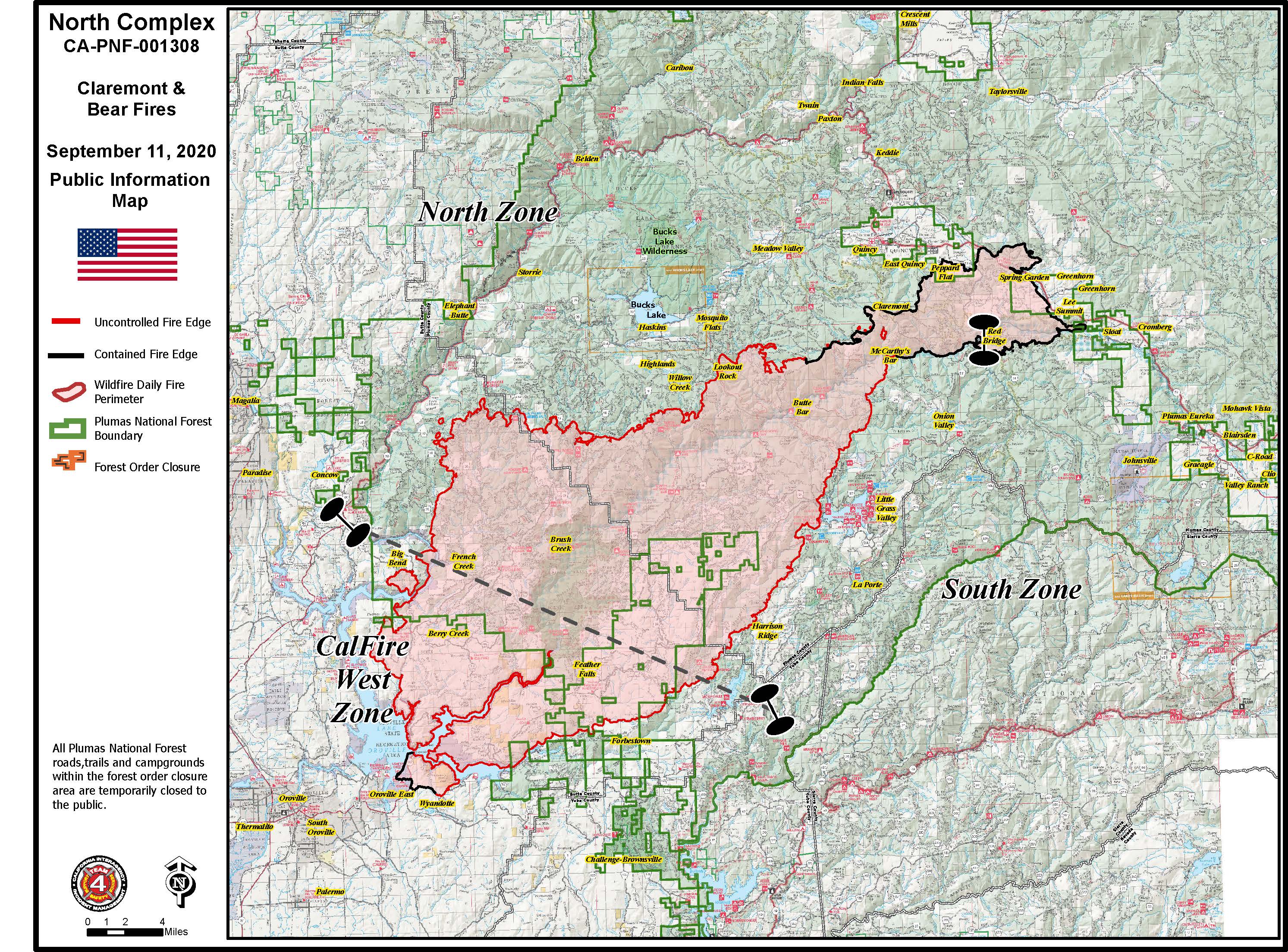
Current Situation
North Zone:
Firefighters continued to make good progress on securing containment lines and there was no significant fire growth. Firing operations will be focused around the Lookout Rock and On-top Mine areas. Structure protection groups continue to work in communities surrounding the fire’s perimeter.
South Zone:
The most activity was located on the western side of Little Grass Valley, where firefighters continue to scout for opportunities to establish direct and indirect line construction. West Zone: This area is being managed by CAL FIRE/Butte County: https://www.fire.ca.gov/incidents/2020/8/18/north-complex-fire/#incident-overview.
Both a detailed morning video operations update for the North and South Zones, and a live virtual joint press conference tonight at 6 p.m. can be viewed on Plumas National Forest’s Facebook page.
Evacuations and Road Closures
Mandatory evacuation orders and evacuation advisories are in place for Butte, Plumas, and Yuba Counties. Check the appropriate county’s Facebook page for their latest information.
Weather and Air Quality
Southwest winds will increase from yesterday with afternoon gusts of up to 18 mph. Significant smoke will remain in the region and will reduce visibility and keep temperatures below normal.
Smoke outlook: fires.airfire.org/outlooks/EasternSierra or www.airnow.gov/
Forest Closures
Due to unprecedented and historic fire conditions throughout the state, the USDA Forest Service Pacific Southwest Region has closed all eighteen National Forests in California, including the Plumas National Forest. https://www.fs.usda.gov/Internet/FSE_DOCUMENTS/fseprd801413.pdf
Meetings are being broadcast daily through Zoom: · Cooperators Meeting daily at 10 A.M.: https://usfs.zoomgov.com/j/1602646317 · Planning Meeting daily at 7 P.M.: https://usfs.zoomgov.com/j/1600484186
Please also see related files for CalFire Team 4's Update
North Complex Smoke Outlook 9122020
Related Incident:
Publication Type: News
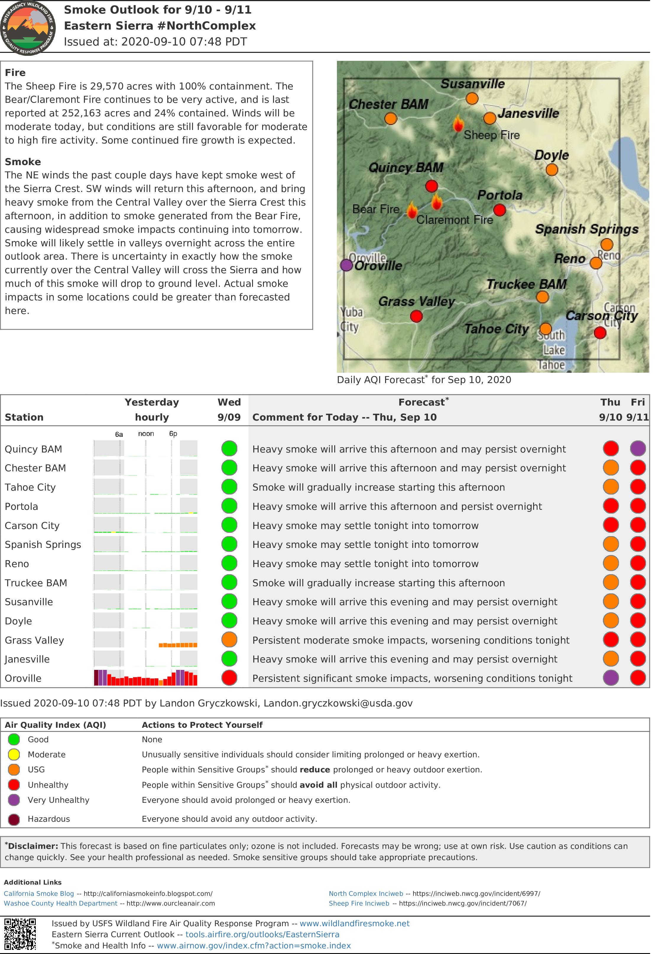
Fire
Smoke
North Complex AM Update 09122020
Related Incident:
Publication Type: News
Current Situation
North Zone:
Firefighters continued to make good progress on securing containment lines and there was no significant fire growth. Firing operations will be focused around the Lookout Rock and Ontop Mine areas. Structure protection groups continue to work in communities surrounding the fire’s perimeter.
South Zone:
The most activity was located on the western side of Little Grass Valley, where firefighters continue to scout for opportunities to establish direct and indirect line construction.
West Zone:
This area is being managed by CAL FIRE/Butte County: https://www.fire.ca.gov/incidents/2020/8/18/north-complex-fire/#incident-overview.
Both a detailed morning video operations update for the North and South Zones, and a live virtual joint press conference tonight at 6 p.m. can be viewed on Plumas National Forest’s Facebook page.
Evacuations and Road Closures
Mandatory evacuation orders and evacuation advisories are in place for Butte, Plumas, and Yuba Counties. Check the appropriate county’s Facebook page for their latest information.
Weather and Air Quality
Southwest winds will increase from yesterday with afternoon gusts of up to 18 mph. Significant smoke will remain in the region and will reduce visibility and keep temperatures below normal.
Smoke outlook: fires.airfire.org/outlooks/EasternSierra or www.airnow.gov/
Forest Closures
Due to unprecedented and historic fire conditions throughout the state, the USDA Forest Service Pacific Southwest Region has closed all eighteen National Forests in California, including the Plumas National Forest. https://www.fs.usda.gov/Internet/FSE_DOCUMENTS/fseprd801413.pdf
Meetings are being broadcast daily through Zoom:
Cooperators Meeting daily at 10 A.M.: https://usfs.zoomgov.com/j/1602646317
Planning Meeting daily at 7 P.M.: https://usfs.zoomgov.com/j/1600484186
North Complex Evening Update September 11th 2020
Related Incident:
Publication Type: News
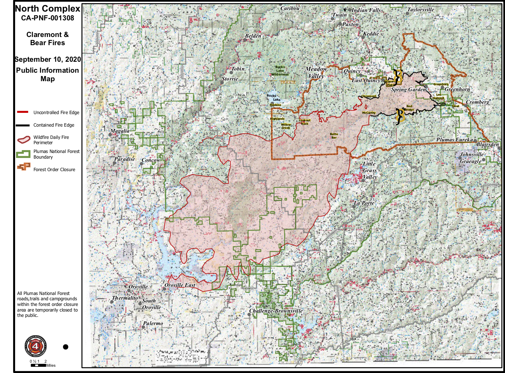
Current Situation
North Zone: Crews continue to create a buffer to slow fire progression and protect the Bucks Lake, Haskins, and Highlands areas. The fire remains 5 miles from the Meadow Valley and Tollgate areas. Fire line in the northeast part of the fire is holding well.
Evacuations and Road Closures
Weather and Air Quality
Forest Closures
Meetings are being broadcast daily through Zoom:
North Complex Fire AM Update 9112020
Related Incident:
Publication Type: News
Current Situation
North Zone: Crews detected and successfully responded to spot fires on the north edge of the fire last night. Today, crews will continue the multi-day project of constructing line to connect to Highway 70 in an area north of Elephant Butte and continue to reinforce structure protection in communities.
Evacuations and Road Closures
Yuba County Sheriff’s Office: https://www.facebook.com/yubacountysheriff
Forest Closures
Cooperators Meeting daily at 10 A.M.: https://usfs.zoomgov.com/j/1602646317
Planning Meeting daily at 7 P.M.: https://usfs.zoomgov.com/j/1600484186
Smoke Outlook for the North Complex September 11 2020
Related Incident:
Publication Type: News
Fire
The Bear/Claremont Fire is now 244,203 acres and 23% contained. The reduction of acres is due to improved mapping. Heavy smoke above the fire led to reduced fire activity yesterday and crews were able to make some progress. Winds will be light to moderate today, but conditions are still favorable for moderate to high fire activity.
Smoke
Winds will be light for most of the day, which will cause smoke to persist throughout the day across the area. Some temporary improvement is likely this afternoon. Smoke will settle into valleys tonight and then slowly dissipate the following morning and afternoon. The area will continue to see smoke coming over the Sierra from the Central Valley, causing widespread impacts. Additionally, SW winds this afternoon will transport smoke from the Bear/Claremont Fire to areas from Chester to Reno. Tahoe City, Truckee, and Carson City will be impacted by smoke from the Fork Fire and the Slink Fire.
North Complex Evening Update September 10 2020
Related Incident:
Publication Type: News
Current Situation
North Zone: From Lee Summit to Claremont Peak, the fire remains in the current footprint. Crews are engaged with tactical firing operations near Lookout Rock and reinforcing structure protection in the Bucks Lake, Haskins, and Highlands areas. Crews are prepping existing roads and building dozer lines to tie in with old fire scars and contingency lines from the Camp Fire. This will eventually tie in with Highway 70 north of Elephant Butte.
Evacuations and Road Closures
Butte County Sheriff’s Office: https://www.facebook.com/bcsonews
Plumas County Sheriff’s Office: https://www.facebook.com/plumascountysheriff
Yuba County Sheriff’s Office: https://www.facebook.com/yubacountysheriff
Planning Meeting daily at 7 P.M.: https://usfs.zoomgov.com/j/1600484186
North Complex Fire AM Update 09102020
Related Incident:
Publication Type: News
Current Situation
Evacuations and Road Closures
Butte County Sheriff’s Office: https://www.facebook.com/bcsonews
Plumas County Sheriff’s Office: https://www.facebook.com/plumascountysheriff
Yuba County Sheriff’s Office: https://www.facebook.com/yubacountysheriff
Typical southwest breezes will return this afternoon with warm and dry conditions. A smoke inversion is likely to increase smoky conditions. For specific smoke impacts to your area, visit www.airnow.gov.
Forest Closures
https://www.fs.usda.gov/Internet/FSE_DOCUMENTS/fseprd801413.pdf
Planning Meeting daily at 7 P.M.: https://usfs.zoomgov.com/j/1600484186
Smoke Outlook for 09102020
Related Incident:
Publication Type: News
The Sheep Fire is 29,570 acres with 100% containment. The
Smoke
The NE winds the past couple days have kept smoke west of