
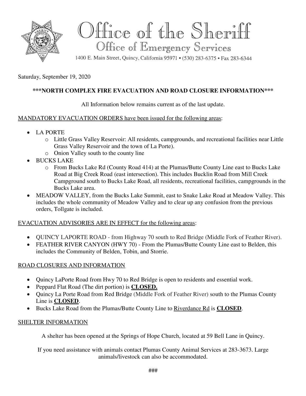
Plumas Co Sheriffs Evacuation Information Updated 9192020
Related Incident:
Publication Type: Announcement
For the most current fire, Evacuation and Road Closure information for Plumas County related to the #NorthComplexFire, click on the Related Information link below. This post supersedes and/or affirms all earlier posts.
Butte Co Sheriffs Evacuation Information Updated 9192020 1000AM
Related Incident:
Publication Type: Announcement
Butte County Sheriff’s Office Evacuation Information
Updated 9/19/2020 10:00 am
EVACUATION ORDERS:
Berry Creek above Simmons Rd, Brush Creek, and Feather Falls communities
EVACUATION WARNINGS
Highway 162 from Bidwell Bar Bridge to Simmons Rd. Simmons Rd to Big Ridge Rd, including all roads that connect with Simmons Rd. Big Ridge Rd will remain closed.
Highway 70 from the West Branch bridge north to Pulga Rd. All areas east to the north fork of the Feather River including the community of Yankee Hill and the Big Bend area.
Area enclosed by Highway 162 from Miner’s Ranch Rd to Forbestown Rd to the Butte County line on the north. Swedes’ Flat Rd on the south. Miner’s Ranch Rd to Swedes’ Flat Rd on the west perimeter. County line on the east perimeter.
Highway 162 from Forbestown Rd, north to the Bidwell Bar bridge to include both sides of the roadway.
Areas north of Forbestown road to Lumpkin Rd including Lake Haven Way and Faye Mar Rd., all of Stringtown Rd and connecting roads.
ROAD CLOSURES:
SR-162 @ SIMMONS RD
SIMMONS RD @ BIG RIDGE RD
SR-162 @ BIDWELL BAR BRIDGE
LUMPKIN ROAD NORTH OF FAYE MAR DR
SR-70 @ FOUR TREES ROAD
FORBESTOWN ROAD @ LOWER FORBESTOWN ROAD
FORBESTOWN ROAD @ WESTAR COURT
This information is updated as soon as practical. For the latest information, check for BCSO “code red” and Facebook/Twitter updates.
North Complex Smoke Outlook 09192020
Related Incident:
Publication Type: News
Fire
The North Complex Fire grew 2,630 acres and is now 289,951 acres at 58% containment. The fire remained active in a few places yesterday, but crews continued to make progress increasing containment. Today expect a slight increase in fire activity due to a higher risk environment from decrease in relative humidity and warmer temperatures
Smoke
Smoke and air quality conditions yesterday overall where in a the good to moderate ranges except Susanville which saw unhealthy smoke levels. Today expect smoke in the morning with a diurnal wind flow decreasing smoke as the day warms. We will have good air quality for communities west of the fire including Oroville and Grass Valley. Reno area which will continue to see smoke from the Creek and SQF Fires with some improvement in air quality from yesterday changing from USG to moderate today. Smoke from the North Complex will flow mainly in the NE direction and may settle into communities such as Susanville in the late afternoon.
H & S
Think of the AQI as a yardstick that runs from 0 to 500. The higher the AQI value, the greater the level of air pollution and the greater the health concern. For example, an AQI value of 50 or below represents good air quality, while an AQI value over 300 represents hazardous air quality.
https://www.airnow.gov/aqi/aqi-basics/
North Complex AM Update 09192020
Related Incident:
Publication Type: News
Incident Start Date: 8/17/2020 Size: 289,951 acres Containment: 58%
Engines: 252 Handcrews: 51 Dozers: 86 Helicopters: 24 Water Tenders: 94 Total Personnel: 2,815
Fatalities: 15 Structures Damaged/Destroyed: 1,454
Current Situation
South Zone:
Mop-up and construction of dozer line from Sly Creek Reservoir up to Onion Valley will continue today. An incoming west-southwest wind pattern will test containment lines in east-west oriented drainages along the entire east flank of the fire. Handline built along Fingerboard Ridge west of LaPorte Road is now ready for tactical firing when weather conditions are favorable. The eastern portion of the fire continues to hold within containment lines.
North Zone:
Today priorities will be tying in containment lines between Willow Creek and Red Mountain, and from Red Mountain west across Granite Basin to Four Trees, working to defend nearby communities. Firing operations will start once these indirect containment lines are built to box in the fire’s edge.
From Four Trees down to Big Bend, crews also made great progress in mop up efforts. Today they plan to continue securing any embers that spot over the north side of Oro-Quincy Road.
West Zone: See CAL FIRE Team 4 updates at: www.fire.ca.gov/incidents/2020/8/18/north-complex-fire/
Twice daily video operational updates are available to watch on the Plumas National Forest Facebook Page, and once daily Zoom broadcasts of Planning and Cooperator meetings on Inciweb (links above).
Evacuations and Road Closures
Orders and Advisories are still in place for communities in Butte, Plumas, and Yuba Counties. Please check your respective county’s websites and Facebook pages for the latest on evacuations and road closures. You can also sign up with your county for reverse 911 notifications by registering with the CODE RED system.
Weather and Air Quality
Winds gradually diminished last night along with lower temperatures and higher humidity. A gradual warming/ drying trend will begin today pushing into next week. High will be 79 degrees and humidity between 23-40%.
Smoke outlook: fires.airfire.org/outlooks/EasternSierra or www.airnow.gov/
Plumas National Forest, forest-wide closure: https://www.fs.usda.gov/alerts/plumas/alerts-notices
California Interagency Incident Management Team 4 is implementing measures to prevent the spread of COVID-19 in both the fire area and surrounding communities.
North Complex Fire PM Update 9182020
Related Incident:
Publication Type: News
Current Situation
North Zone:
Firefighters contained the large 200-acre spot fire at Grizzly Lake area today, and monitored for any spot fires from Willow Creek west to Red Mountain and Frog Rock. Tonight and into tomorrow they will focus on tying in containment line between Willow Creek and Red Mountain, and from Red Mountain across Granite Basin to Four Trees, working to defend nearby communities. Firing operations will start once these indirect containment lines are built to box in the fire’s edge.
From Four Trees down to Big Bend, crews also made great progress in mop up efforts.
Twice daily video operational updates are available to watch on the Plumas National Forest Facebook Page, and once daily Zoom broadcasts of Planning and Cooperator meetings on Inciweb (links above).
Evacuations and Road Closures
Plumas National Forest, forest-wide closure:https://www.fs.usda.gov/alerts/plumas/alerts-notices
North Complex Smoke Outlook 9182020
Related Incident:
Publication Type: News
Fire
The North Complex Fire grew 6546 acres and is now 287,321 acres at 41 % containment. The fire remained active in a few places yesterday, but crews continued to make progress. Today expect a slight decrease in fire activity due to a moderate risk environment from increase in relative humidity and less wind speed.
Smoke
Smoke and air quality conditions should be better than yesterday with the exception of the Reno area which will continue to see smoke from the Creek and SQF Fires with little improvement in air quality changing from USG to moderate today. Smoke from the North Complex will flow mainly to the NE direction transporting smoke towards the Susanville area. Areas North and South of the fire will see improvements in air quality from USG to Moderate ranges. Expect good air quality throughout the day in the Grass Valley and Oroville area.
H&S
When looking at this Smoke Outlook think of it as a tool to plan your day. If the area that you reside in has poor air quality and you desire outdoor activity, think about going to an area that is green (good air quality) if you want outdoor recreation. https://fires.airfire.org/outlooks
North Complex Fire AM Update 9182020
Related Incident:
Publication Type: News
Current Situation
South Zone: Slightly calmer weather last night helped firefighters gain depth on mop up and containment on hand lines. Crews continued constructing indirect hand line tying into the middle fork of the Feather River along Fingerboard Ridge.
North Zone: Last night fire activity was fairly calm. Crews worked on containing the spot fires north of Red Mountain but there was no significant growth. Firefighters will continue to hold and mop-up in that area today, preventing threats to current containment lines and getting around slopovers.
In the western portion of the fire, crews held the fire in check and plan to continue preparing Oro-Quincy Highway from the Four Trees area to Big Bend. West Zone: See CAL FIRE Team 4 updates at: www.fire.ca.gov/incidents/2020/8/18/north-complex-fire/
Several structure protection groups are in place surrounding the most active areas of the fire perimeter to protect nearby communities. Strategic firing operations and aircraft support will take place as weather conditions allow.
Twice daily video operational updates are available to watch on the Plumas National Forest Facebook Page, and once daily Zoom broadcasts of Planning and Cooperator meetings on Inciweb (links above).
Evacuations and Road Closures
Orders and Advisories are still in place for communities in Butte, Plumas, and Yuba Counties. Please check your respective county’s websites and Facebook pages for the latest on evacuations and road closures. You can also sign up with your county for reverse 911 notifications by registering with the CODE RED system.
Weather and Air Quality
Southwest winds brought gusts up to 35 last night with the incoming cold front. Today winds are expected to gradually diminish throughout the afternoon but may have gusts up to 20 mph. Smoke outlook: fires.airfire.org/outlooks/EasternSierra or www.airnow.gov/ Forest-wide closure extended: https://www.fs.usda.gov/Internet/FSE_DOCUMENTS/fseprd804760.pdfNorth Complex Fire PM Update 9172020
Related Incident:
Publication Type: News
Current Situation
South Zone:
Firefighters continue to make progress gaining containment from Sly Creek Reservoir to Little Grass Valley.
Winds were strong earlier in the day within the steep terrain of Onion Valley. Crews worked hard to continue constructing indirect hand line tying into the middle fork of the Feather River along Fingerboard Ridge. This is a parallel ridgeline west of LaPorte Road. Helicopters were able to make drops in this active area of the fire to assist ground crews in inaccessible terrain. Smoke produced from this area of the fire blew northwest into Quincy and its surrounding communities east along highway 70.
North Zone:
Efforts to contain spot fires north of Red Mountain and Willow Creek continued today with hand crews and bulldozers. Crews are working hard to contain the spot fire using existing roads, while also preparing indirect containment lines west to Oro-Quincy Highway. Helicopters were also able to get in the air today to assist ground crews with the large spot fire near Grizzly Lake.
In the western portion of the fire, crews held the fire in check and plan to continue preparing Oro-Quincy Highway from the Four Trees area to Big Bend. West Zone: See CAL FIRE Team 4 updates at: www.fire.ca.gov/incidents/2020/8/18/north-complex-fire/
Several structure protection groups are in place surrounding the most active areas of the fire perimeter to protect nearby communities.
Twice daily video operational updates are available to watch on the Plumas National Forest Facebook Page, and once daily Zoom broadcasts of Planning and Cooperator meetings on Inciweb (links above).
Evacuations and Road Closures
The Evacuation Advisory status in Meadow Valley and Tollgate was moved into an Evacuation Order at 10:00 a.m. by the Plumas County Sheriff’s office.
Orders and Advisories are still in place for communities in Butte, Plumas, and Yuba Counties. Please check your respective county’s websites and Facebook pages for the latest on evacuations and road closures. You can also sign up with your county for reverse 911 notifications by registering with the CODE RED system.
Weather and Air Quality
Southwest winds increased this afternoon, bringing gusts up to 35 mph and pushing smoke and ash outfall northeast. Tonight, the incoming cold front will bring more gusty and erratic winds at times up to 25 mph. Smoke outlook: fires.airfire.org/outlooks/EasternSierra or www.airnow.gov/ Forest-wide closure extended: https://www.fs.usda.gov/Internet/FSE_DOCUMENTS/fseprd804760.pdf
North Complex Smoke Outlook 9172020
Related Incident:
Publication Type: News
Fire
The North Complex Fire grew 7,440 acres and is now 280,775 acres at 36% containment. The fire remained very active in a few places yesterday, but crews continue to make progress. Active fire behavior is expected this afternoon due to predicted wind gusts from a trough moving into the area.
Smoke
Smoke and air quality conditions today will be similar to yesterday trending toward less smoke in the afternoon due to the increase in SW winds. Smoke from the North Complex will continue to be transported towards areas between Chester and Janesville, including Susanville, Greenville, and Westwood. The Reno, Carson City, and Tahoe areas will continue to see smoke from the Creek and SQF Fires. This afternoon, expect increased SW winds to lead to some improvement in air quality, except for areas directly downwind of the North Complex which will continue to see smoke impacts.
Plumas County Mandatory Evacuation Order
Related Incident:
Publication Type: Announcement
PLUMAS COUNTY MANDATORY EVACUATION ORDER
A MANDATORY Evacuation order has been issued for the Community of Meadow Valley due to a wildfire. This includes all areas in between Big Creek/Bucks Lake Road intersection, east to Snake Lake Road. You should leave the area immediately! If you remain, emergency personnel may not be able to help you. An evacuation center is being set up at the Springs of Hope Church located at 59 Bell Lane Quincy. Emergency personnel will be going door to door to conduct in person notifications.