
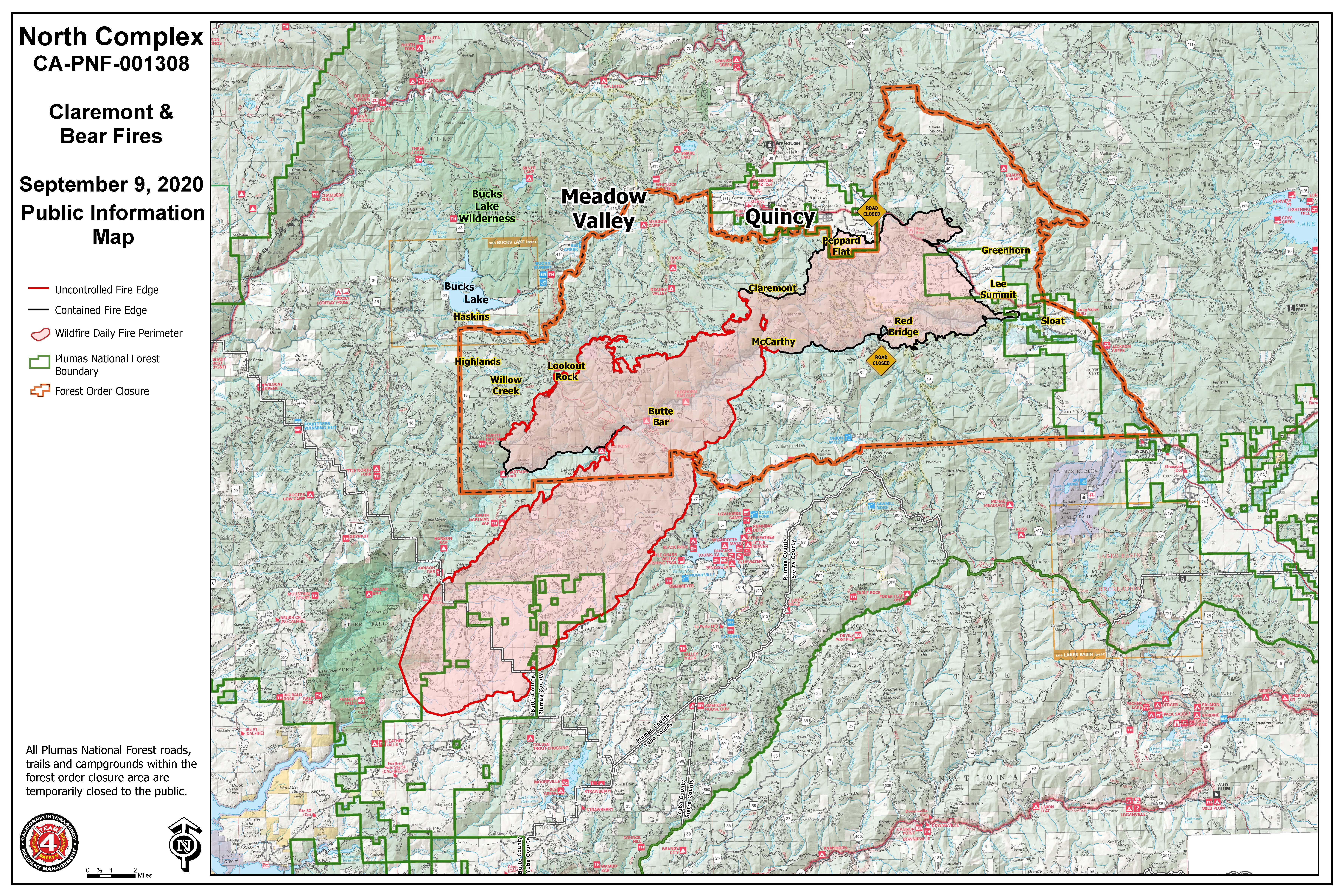
Morning Update for September 9 2020
Related Incident:
Publication Type: News
Current Situation
The North Complex Fire experienced extreme fire behavior and growth throughout the night after jumping the
Middle Fork of the Feather River yesterday morning. Topography, high winds, and dry fuels aligned to produce unprecedented fire behavior. Spread rates of 1,000 acres per 30 minutes resulted in an additional 80,000 acres being added to the North Complex to the southwest of the original footprint. This is an evolving incident; maps and current fire size are constantly being updated and will be shared when available.
Firefighter and public safety remains the highest priority. Multiple communities have been evacuated with a likelihood of additional evacuations today. In light of this quickly evolving situation, the most up-to-date information will be found at the sheriff office websites shown below for Plumas, Butte, and Yuba counties.
A Virtual Community Meeting will be broadcast tonight on Facebook at 6 p.m.
Evacuations and Road Closures
Mandatory evacuation areas continue to be expanded. Evacuation shelters have been established. Check the appropriate county’s Facebook Page for their latest information as the situation is being constantly updated.
Mandatory evacuation areas continue to be expanded. Evacuation shelters have been established. Check the appropriate county’s Facebook Page for their latest information as the situation is being constantly updated.
Plumas County Sheriff's Office
Butte County Sheriff's Office
Yuba County Sheriff's Office
Weather and Air Quality
A Red Flag Warning remains in effect. Very dry air and gusty east/northeast winds will persist through the morning before decreasing and shifting east by early afternoon. For specific smoke impacts to your area, visit https://www.airnow.gov.Forest Closures
A USFS order prohibits the use of any ignition (campfires, gas stoves, etc.) and the closure of all developed campgrounds and day-use sites on National Forests in California. No overnight camping of any kind, including dispersed camping, is allowed on the Plumas National Forest except within the wilderness area and alongside the Pacific Crest Trail. An earlier order remains in effect closing all trails, roads, and campgrounds around the North Complex Fire.
Plumas NF: https://www.fs.usda.gov/alerts/plumas/alerts-notices.
Lassen NF: https://www.fs.usda.gov/alerts/lassen/alerts-notices
Meetings are being broadcast daily through Zoom:
-
A Virtual Community Meeting will be broadcast tonight on Facebook at 6 p.m. (note time change from some earlier announcements)
-
Cooperators Meeting Daily at 10 a.m.: https://usfs.zoomgov.com/j/1602646317
-
Planning Meeting Daily at 7 p.m.: https://usfs.zoomgov.com/j/1600484186
Smoke Outlook 992020
Related Incident:
Publication Type: News
Fire
The Sheep Fire remains 29,570 acres with 90% containment. The Bear/Claremont fire spotted across the Middle Fork Feather River and made a substantial run towards Lake Oroville. Winds will be moderate today, but conditions are still favorable for active fire behavior. Continued fire growth is expected. Updated acres are not available as of the publishing of this Outlook. Please visit the Inciweb or Facebook websites for updates (Inciweb link below).
Smoke
NE and E winds today will bring heavy smoke towards the Oroville area and the Central Valley. Areas north and east of the fire will continue to see Good air quality. Tomorrow, winds will shift back to the SW, bringing smoke over the Sierra and impacting all of the Outlook area, especially tomorrow night.
Fire Weather Alert
A Red Flag Warning is currently in effect through 5pm Wednesday due to gusty winds and low humidity. More information: www.weather.gov/sto/
Butte County EVACUATION WARNING 150 AM
Related Incident:
Publication Type: Announcement
EVACUATION WARNING 9.9.20 1:50 am The Butte County Sheriff’s Office is issuing an EVACUATION WARNING for the area of Highway 70 at Garden Dr., south to Lower Honcut Rd., Lower Honcut Rd. East to Bangor and everything East to the borders of the current immediate evacuation orders.
A map of the areas affected can be found by clicking on the link below. www.sartopo.com/m/bd55
Butte County EVACUATION ORDER 1225 am
Related Incident:
Publication Type: Announcement
Butte County - EVACUATION ORDER 9.9.20 12:25 a.m. The Butte County Sheriff's Office is issuing an IMMEDIATE EVACUATION ORDER for Cherokee Road at Highway 70, south to Thompson Flat Cemetery Road, and all areas east to Lake Oroville.
A Temporary Evacuation point has been established at Church of the Nazarene 2238 Monte Vista Avenue in Oroville.
Yuba County Evacuation Update Midnight
Related Incident:
Publication Type: Announcement
Mandatory Evacuations have been expanded in Yuba County. The map is difficult the read, but evacuations begin along the northern Yuba County border from Strawberry Valley to Forbestown and south to Rackerby and Brownsville-Challenge all the way over the upper portion of Bullards Bar Reservoir. Take routes to the south to move away from the fire zone.
Please take this evacuation seriously and begin moving immediately, to allow plenty of time to get to safety. The Yuba-Sutter Fairgrounds in Yuba City is prepared to receive evacuees.
Butte County EVACUATION ORDER 9820 1100 pm
Related Incident:
Publication Type: Announcement
Butte County - EVACUATION ORDER 9.8.20 11:00 p.m.The Butte County Sheriff’s Office is upgrading the EVACUATION WARNING to an IMMEDIATE EVACUATION ORDER for the communities of Kelly Ridge and Copley Acres.
All previous EVACUATION WARNINGS are now EVACUATION ORDERS.
Butte County EVACUATION ORDER 1038 pm
Related Incident:
Publication Type: Announcement
Butte County - EVACUATION ORDER 10:38 p.m.
The Butte County Sheriff’s Office is upgrading the EVACUATION WARNING to an IMMEDIATE EVACUATION ORDER for residents living east of Miners Ranch Road at Highway 162 and Oro-Bangor Highway, which includes Bangor and part of the Mt. Ida area. A map of the affected areas can be found here: www.sartopo.com/m/bd55
Evening Update for Sept 8 2020
Related Incident:
Publication Type: News
Current Situation
Today was a critical fire day with extreme fire behavior. The fire jumped the Middle Fork of the Feather River around 10 a.m. A dry cold front passing over the fire with very high winds and low humidities rapidly drove the high-intensity crown fire to the southwest. Firefighters are focusing efforts on structure protection within the evacuated communities and holding current anchor points tonight.
The eastern half of the North Complex Fire experienced active burning within the interior today, but containment lines held.
A Virtual Community Meeting will be held tomorrow, Wednesday September 9 at 5 p.m. The meeting can be viewed at https://www.facebook.com/USFSPlumas.
Evacuations and Road Closures
Mandatory evacuation orders of 20,000 residents were issued by Plumas, Butte, and Yuba county sheriffs’ offices. Evacuation shelters have been established. Check the appropriate county’s Facebook Page for their latest information. · Plumas County Sheriff’s Office: https://www.facebook.com/plumascountysheriff · Butte County Sheriff’s Office: https://www.facebook.com/bcsonews · Yuba County Sheriff’s Office: https://www.facebook.com/yubacountysheriff
Temporary evacuation staging areas have been established at:
· Dobbins Alcouffee Center, located at 9185 Marysville Rd, Oregon House, CA
· Yuba-Sutter Fairgrounds at 442 Franklin Ave, Yuba City, CA
Evacuation advisories remain in effect for the Bucks Lake area and Quincy LaPorte Road from Highway 70 south to Thompson Creek.
Weather and Air Quality
A Red Flag Warning is in effect through Wednesday at 5 p.m. Critical Fire Weather conditions are occurring due to gusty winds and low humidity. Winds of 10-15 mph with gusts to 35 mph are forecasted over the fire area tonight. For specific smoke impacts to your area, visit www.airnow.gov.
Forest Closures
A USFS order prohibits the use of any ignition (campfires, gas stoves, etc.) and the closure of all developed campgrounds and day-use sites on National Forests in California. No overnight camping of any kind, including dispersed camping, is allowed on the Plumas National Forest except within the wilderness area and alongside the Pacific Crest Trail. An earlier order remains in effect closing all trails, roads, and campgrounds around the North Complex Fire. Plumas NF: https://www.fs.usda.gov/alerts/plumas/alerts-notices. Lassen NF: www.fs.usda.gov/alerts/lassen/alerts-notices
Meetings are being broadcast daily through Zoom:
· Virtual Community Meeting Wednesday, September 9 at 5 p.m. View at https://www.facebook.com/USFSPlumas · Planning Meeting Daily at 7 p.m.: https://usfs.zoomgov.com/j/1600484186 · Cooperators Meeting Thursday, September 10 at 10 a.m.: https://usfs.zoomgov.com/j/1602646317
Sheep Fire
The Sheep Fire is 29,570 acres with 95% containment. For future updates on the Sheep Fire, go to https://inciweb.nwcg.gov/incident/7067/.
Evacuation staging area update
Related Incident:
Publication Type: Announcement
Ponderosa Community Center Evacuation staging area is closing. Evacuees can continue to the Alcouffe Center in Oregon House or the Yuba Sutter Fairgrounds for assistance if needed. The current evacuation order remains in effect.
North Complex Midday Update September 8 2020
Related Incident:
Publication Type: News
Current Situation
Today at approximately 10 a.m., North Complex fire air attack identified a spot fire south of the Middle Fork of the Feather River near Horseshoe Bend. Within an hour the spot fire was estimated to be 1,000 acres. Wind speeds up to 45 mph are carrying the fire quickly to the southwest through tree crowns. At 3 p.m. the spot fire was estimated to be 20,000 acres and moved fifteen miles to the southwest.
Plumas County Sheriff’s Office: https://www.facebook.com/plumascountysheriff
Butte County Sheriff’s Office: https://www.facebook.com/bcsonews
Yuba County Sheriff’s Office: https://www.facebook.com/yubacountysheriff
For the latest Operational Update video explaining the situation as of 3 p.m., see https://www.facebook.com/USFSPlumas/videos/652183065679319
A Red Flag Warning is in effect through Wednesday at 5 p.m. Critical Fire Weather conditions are occurring due to gusty winds and low humidity.
Plumas NF: https://www.fs.usda.gov/alerts/plumas/alerts-notices.
Lassen NF: www.fs.usda.gov/alerts/lassen/alerts-notices
Meetings are being broadcasted daily through Zoom:
Planning Meeting (Daily at 7 p.m.): https://usfs.zoomgov.com/j/1600484186
Cooperators Meeting (Thursday, September 10 at 10 a.m.): https://usfs.zoomgov.com/j/1602646317