
Air Quality and Smoke Report 9172020
Related Incident:
Publication Type: Announcement
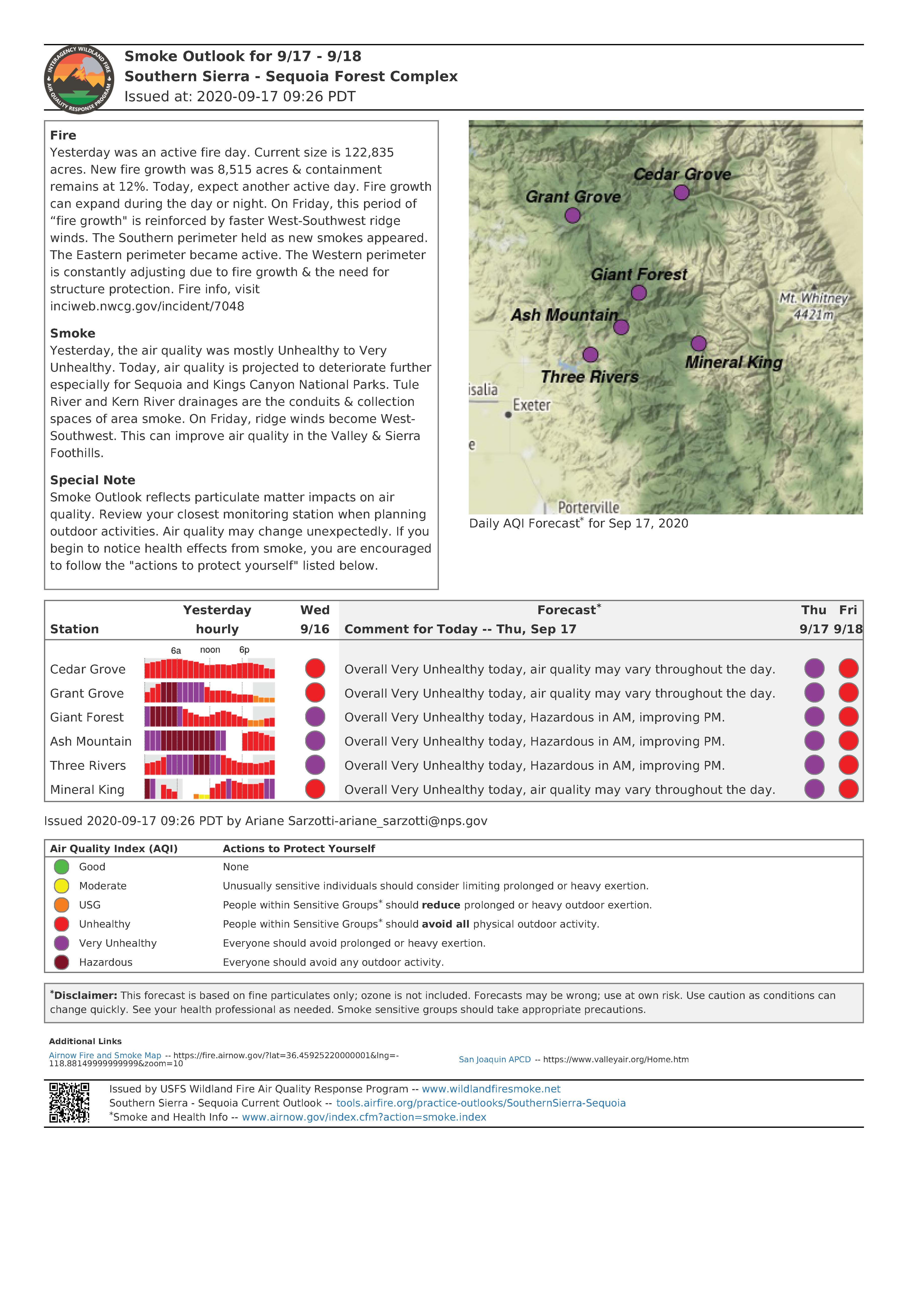
Fire
Yesterday was an active fire day. Current size is 122,835
acres. New fire growth was 8,515 acres & containment
remains at 12%. Today, expect another active day. Fire growth
can expand during the day or night. On Friday, this period of
“fire growth" is reinforced by faster West-Southwest ridge
winds. The Southern perimeter held as new smokes appeared.
The Eastern perimeter became active. The Western perimeter
is constantly adjusting due to fire growth & the need for
structure protection. Fire info, visit
inciweb.nwcg.gov/incident/7048
Smoke
Yesterday, the air quality was mostly Unhealthy to Very
Unhealthy. Today, air quality is projected to deteriorate further
especially for Sequoia and Kings Canyon National Parks. Tule
River and Kern River drainages are the conduits & collection
spaces of area smoke. On Friday, ridge winds become West-
Southwest. This can improve air quality in the Valley & Sierra
Foothills.
Special Note
Smoke Outlook reflects particulate matter impacts on air
quality. Review your closest monitoring station when planning
outdoor activities. Air quality may change unexpectedly. If you
begin to notice health effects from smoke, you are encouraged
to follow the "actions to protect yourself" listed below.
Air Quality and Smoke Report 9162020
Related Incident:
Publication Type: Announcement
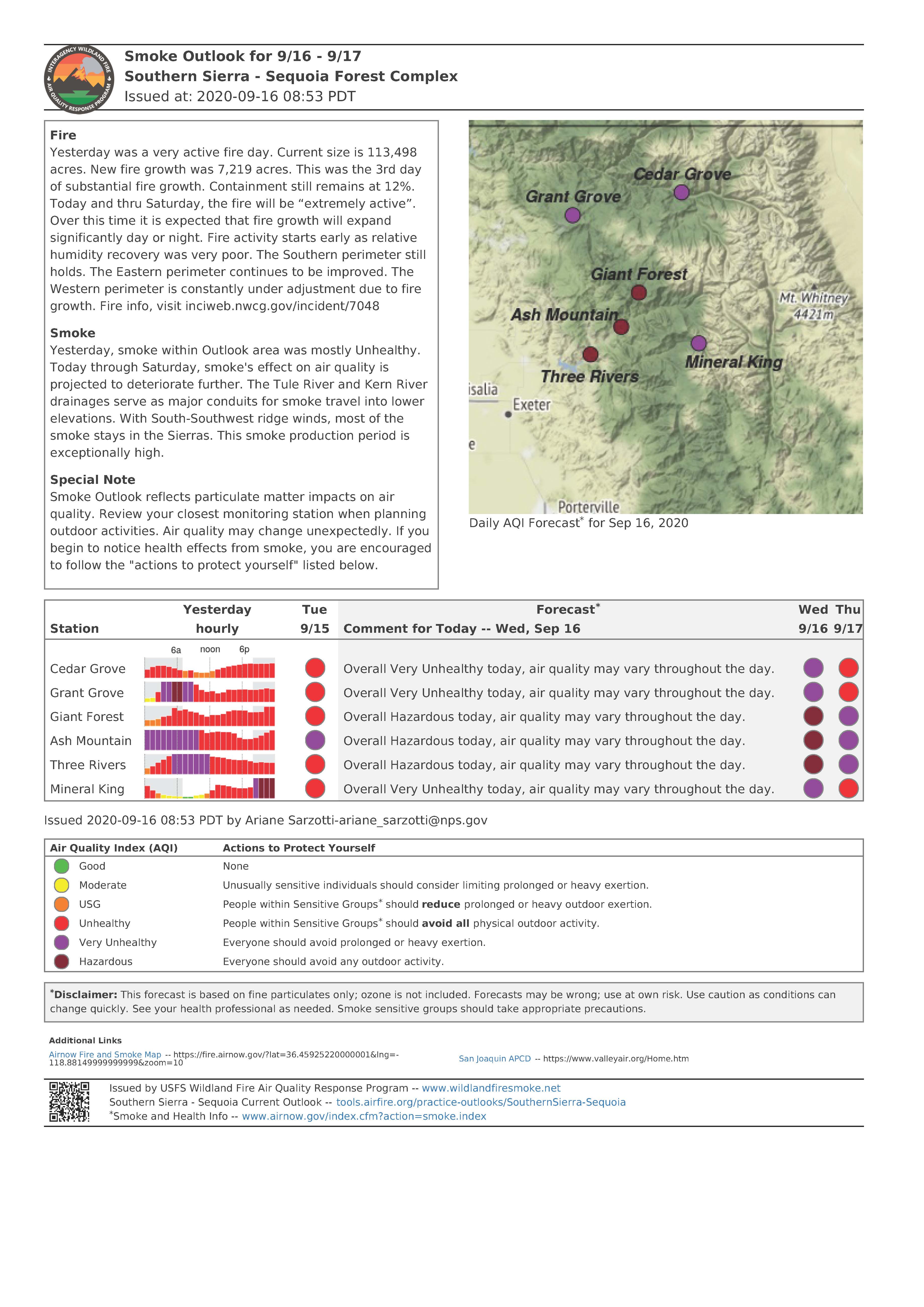
Fire
Yesterday was a very active fire day. Current size is 113,498
acres. New fire growth was 7,219 acres. This was the 3rd day
of substantial fire growth. Containment still remains at 12%.
Today and thru Saturday, the fire will be “extremely active”.
Over this time it is expected that fire growth will expand
significantly day or night. Fire activity starts early as relative
humidity recovery was very poor. The Southern perimeter still
holds. The Eastern perimeter continues to be improved. The
Western perimeter is constantly under adjustment due to fire
growth. Fire info, visit inciweb.nwcg.gov/incident/7048
Smoke
Yesterday, smoke within Outlook area was mostly Unhealthy.
Today through Saturday, smoke's effect on air quality is
projected to deteriorate further. The Tule River and Kern River
drainages serve as major conduits for smoke travel into lower
elevations. With South-Southwest ridge winds, most of the
smoke stays in the Sierras. This smoke production period is
exceptionally high.
Special Note
Smoke Outlook reflects particulate matter impacts on air
quality. Review your closest monitoring station when planning
outdoor activities. Air quality may change unexpectedly. If you
begin to notice health effects from smoke, you are encouraged
to follow the "actions to protect yourself" listed below.
Air Quality and Smoke Information 9152020
Related Incident:
Publication Type: Announcement
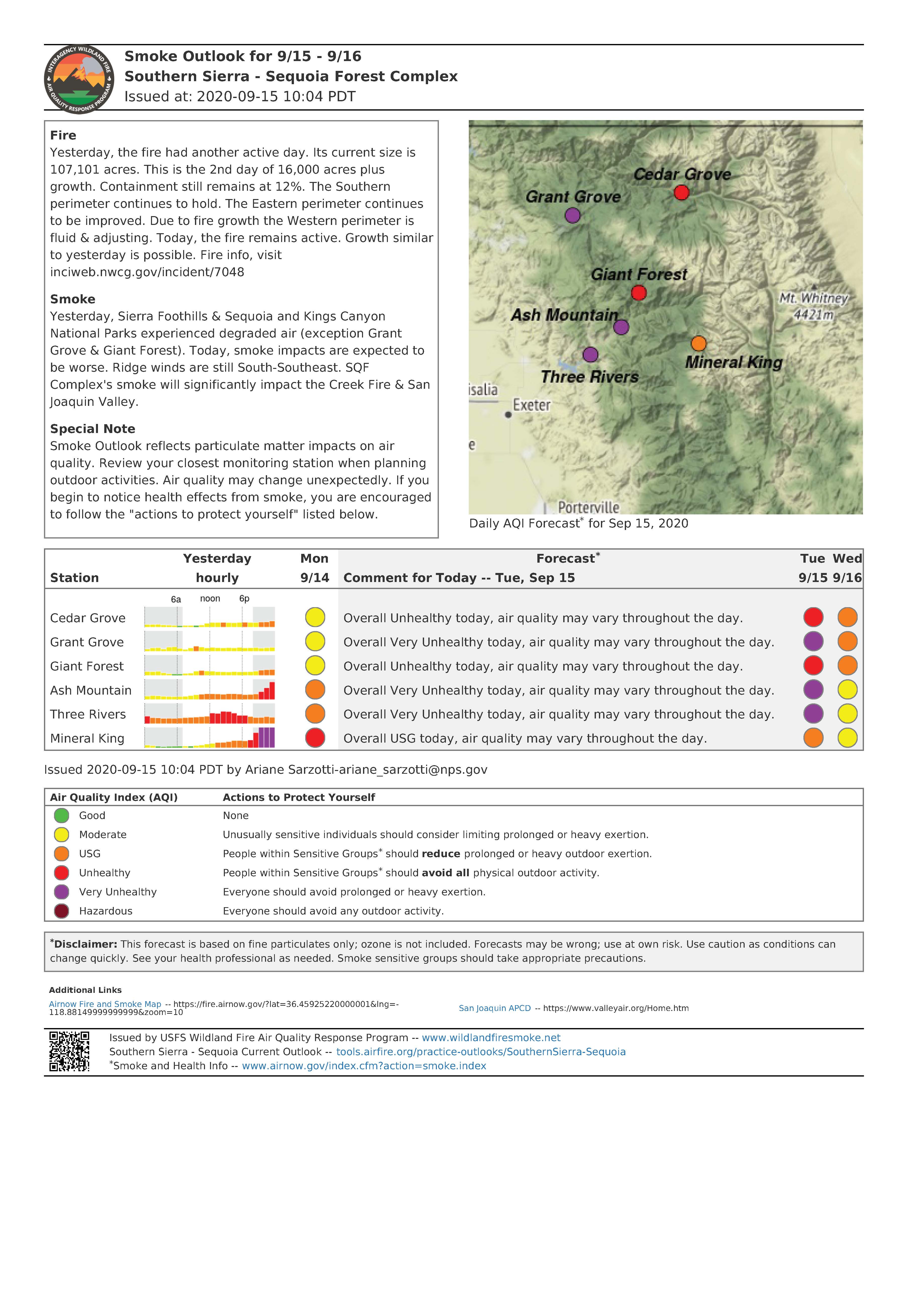
Fire
Yesterday, the fire had another active day. Its current size is
107,101 acres. This is the 2nd day of 16,000 acres plus
growth. Containment still remains at 12%. The Southern
perimeter continues to hold. The Eastern perimeter continues
to be improved. Due to fire growth the Western perimeter is
fluid & adjusting. Today, the fire remains active. Growth similar
to yesterday is possible. Fire info, visit
inciweb.nwcg.gov/incident/7048
Smoke
Yesterday, Sierra Foothills & Sequoia and Kings Canyon
National Parks experienced degraded air (exception Grant
Grove & Giant Forest). Today, smoke impacts are expected to
be worse. Ridge winds are still South-Southeast. SQF
Complex's smoke will significantly impact the Creek Fire & San
Joaquin Valley.
Special Note
Smoke Outlook reflects particulate matter impacts on air
quality. Review your closest monitoring station when planning
outdoor activities. Air quality may change unexpectedly. If you
begin to notice health effects from smoke, you are encouraged
to follow the "actions to protect yourself" listed below.
Air Quality and Smoke Information 9142020
Related Incident:
Publication Type: Announcement
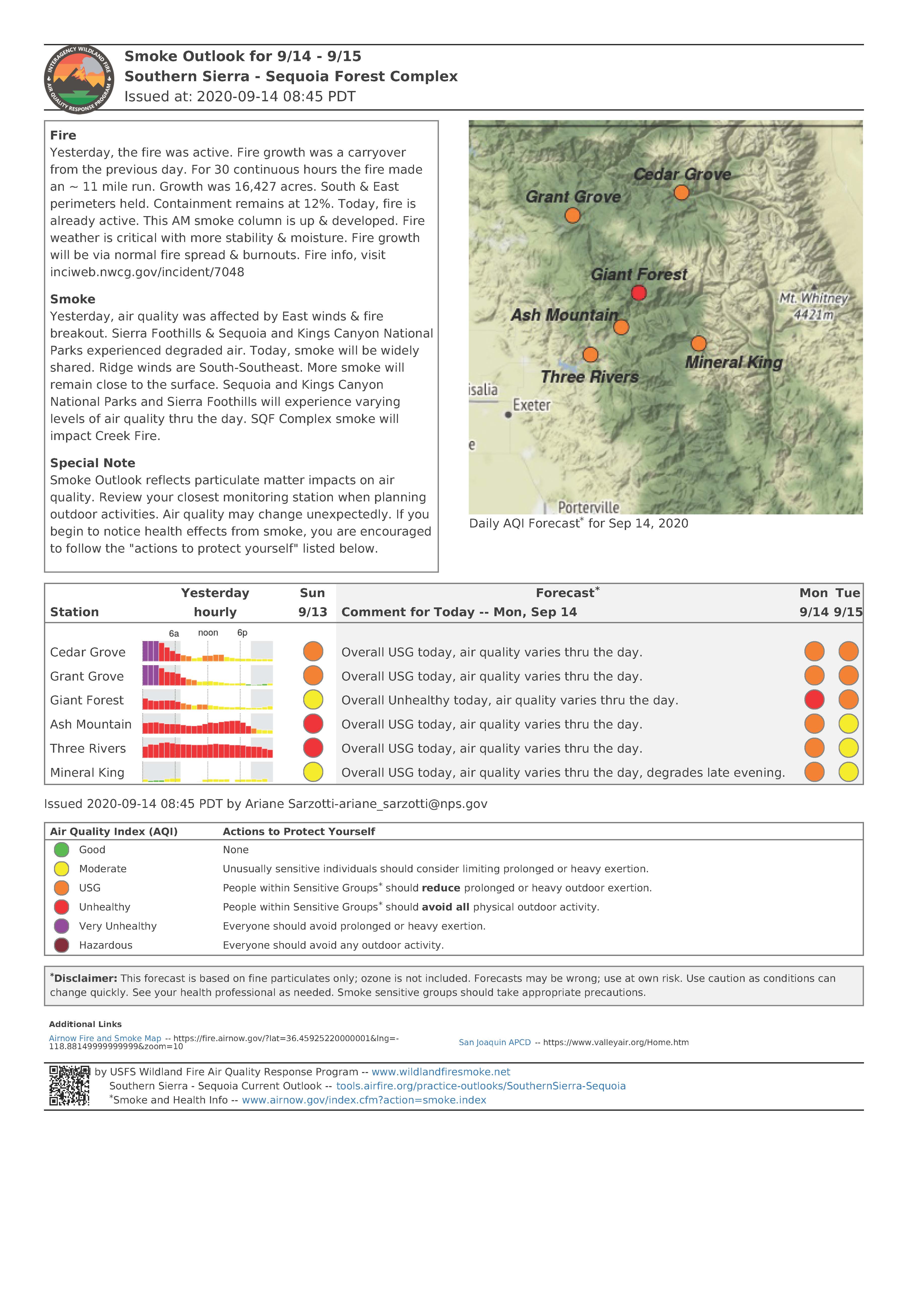
Fire
Yesterday, the fire was active. Fire growth was a carryover from the previous day. For 30 continuous hours the fire made an ~ 11 mile run. Growth was 16,427 acres. South & East perimeters held. Containment remains at 12%. Today, fire is already active. This AM smoke column is up & developed. Fire weather is critical with more stability & moisture. Fire growth will be via normal fire spread & burnouts. Fire info, visit inciweb.nwcg.gov/incident/7048
Smoke
Yesterday, air quality was affected by East winds & fire breakout. Sierra Foothills & Sequoia and Kings Canyon National Parks experienced degraded air. Today, smoke will be widely shared. Ridge winds are South-Southeast. More smoke will remain close to the surface. Sequoia and Kings Canyon National Parks and Sierra Foothills will experience varying levels of air quality thru the day. SQF Complex smoke will impact Creek Fire.
Special Note
Smoke Outlook reflects particulate matter impacts on air quality. Review your closest monitoring station when planning outdoor activities. Air quality may change unexpectedly. If you begin to notice health effects from smoke, you are encouraged to follow the "actions to protect yourself" listed below.
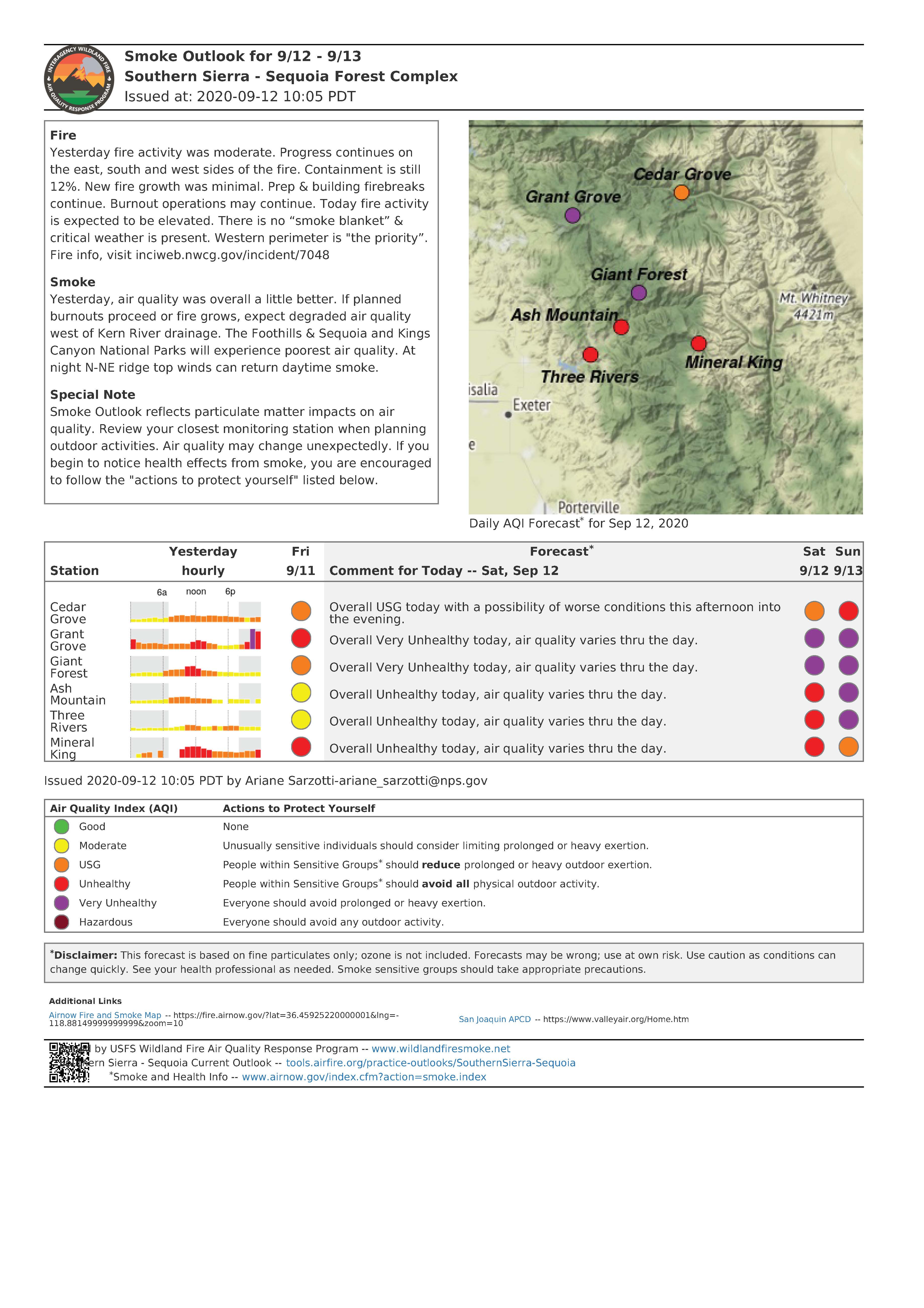
Air Quality for Sequoia and Kings Canyon National Parks 9132020
Related Incident:
Publication Type: Announcement
Fire
Yesterday fire activity was moderate. Progress continues on
the east, south and west sides of the fire. Containment is still
12%. New fire growth was minimal. Prep & building firebreaks
continue. Burnout operations may continue. Today fire activity
is expected to be elevated. There is no “smoke blanket” &
critical weather is present. Western perimeter is "the priority”.
Fire info, visit inciweb.nwcg.gov/incident/7048
Smoke
Yesterday, air quality was overall a little better. If planned
burnouts proceed or fire grows, expect degraded air quality
west of Kern River drainage. The Foothills & Sequoia and Kings
Canyon National Parks will experience poorest air quality. At
night N-NE ridge top winds can return daytime smoke.
Special Note
Smoke Outlook reflects particulate matter impacts on air
quality. Review your closest monitoring station when planning
outdoor activities. Air quality may change unexpectedly. If you
begin to notice health effects from smoke, you are encouraged
to follow the "actions to protect yourself" listed below.
Fires Continue to Burn in Sequoia and Kings Canyon National Parks
Related Incident:
Publication Type: News
SEQUOIA AND KINGS CANYON NATIONAL PARKS, Calif. September 9, 2020 – Two fires are being monitored in Sequoia and Kings Canyon National Parks within the designated wilderness. Both fires are naturally caused lightning strikes. The fires are slow-growing and display creeping and smoldering behavior deep within the wilderness boundaries, offering no threat to human safety or loss of property.
Considering the location and activity of the Moraine and Rattlesnake Fires, Sequoia and Kings Canyon National Parks are utilizing a less intensive suppression strategy. The Moraine Fire, 575 acres and 70% contained, is being managed with minimal impact suppression techniques while using the natural landscape to assist in efforts. Natural rock features, trails and other natural barriers are acting as containment lines to allow firefighters to focus on other large fires in the region.
The Rattlesnake Fire, 1060 acres and 0% contained, is also being managed using similar tactics as the Moraine Fire. Rattlesnake Fire continues to grow each day but is displaying steady fire activity at this time. Due to this growth, Sequoia National Park has expanded the previous area closure. Beginning at the south boundary of Sequoia National Park with the intersection of the Great Western Divide, north along the Great Western Divide to Kaweah Gap, southeast to Chagoopa Plateau along the base of the Kaweah Peaks to the Kern Canyon, north to Junction Meadow and the Colby Pass Trail (not included), east along the High Sierra Trail (not included) to the John Muir Trail/PCT (not included), south along the PCT (not included) to the park boundary, and west along the park boundary back to the point of origin.
The Generals Highway, the main road through the parks, remains open at this time allowing visitors access to the giant sequoias in both Sequoia and Kings Canyon National Parks.
For more information on Rattlesnake Fire, including a closure map, please go to: inciweb.nwcg.gov/incident/7131/
For more information on the Moraine Fire, please go to: inciweb.nwcg.gov/incident/7089/
-NPS-
About Sequoia and Kings Canyon National Parks’ Fire Management Program
For over fifty years, our mission has been to use the full range of options and strategies available to manage fire in the parks. This includes protecting park resources, employees, and the public from unwanted fire; building and maintaining fire resilient ecosystems; reducing the threat to local communities from wildfires emanating from the parks or adjacent lands; and recruiting, training, and retaining a professional fire management workforce.
Air Quallity and Smoke Information
Related Incident:
Publication Type: Announcement
The parks are experiencing an increase in smoke concentrations due to area wildfires.
For additional information regarding air quality and wildland fire smoke please visit the website below which has an interactive version automatically updates the hourly PM2.5 data.
https://wildlandfiresmoke.net/outlooks/SouthernSierra-Sequoia
Also, check smoke conditions at the following areas:
Lad 1 Fire Final Update
Related Incident:
Publication Type: News
The Lad #1 Fire is 192 acres, 100% contained. State resources will continue to monitor throughout the day before turning back over to the local fire departments to monitor.
Lad 1 Fire September 2 1115 AM Update
Related Incident:
Publication Type: News
Lad #1 Fire: 192 acres, 90% contained
Location: approximately 3 miles south of Barnhart, Texas
Resources have returned to continue fire suppression efforts. Engine crews will continue to patrol and mop up of hot spots close to the fire perimeter.
Lad 1 Fire September 1 830 PM Update
Related Incident:
Publication Type: News
Lad #1 Fire: 192 acres, 90% contained
Location: approximately 3 miles south of Barnhart, Texas
Resources made progress on containment line construction and fire suppression today. Crews will return tomorrow for patrol and mop up of hot spots close to the fire perimeter.