
Creek Fire Incident Briefing via Facebook Live
Related Incident:
Publication Type: Announcement
Creek Fire Incident Briefing will be aired this evening starting at 7 PM on the Sierra National Forest Facebook page > https://www.facebook.com/SierraNF
Sierra National Forest Closure effective Monday September 7
Related Incident:
Publication Type: Closures

Creek Fire continues 207 people safely evacuated
Related Incident:
Publication Type: News
The Creek Fire a fast-moving fire burning on both Districts of the Forest. The fire which started near the communities of Big Creek and Huntington Lake, moved very quickly prompting several evacuations.
Early Saturday afternoon the fire crossed the San Joaquin River and made a run into the Mammoth Pool area. Prompting some members of the public to shelter in place near Wagner’s Store and Campground. With assistance of the California Army National Guard, 207 people were safely evacuated and have been assessed for medical needs.
The fire burned actively overnight. Crews will be challenged today by steep rugged terrain, heavy fuel loading and high temperatures. Additional resources have been ordered including a Type 1 Incident Management Team. Evacuations and closures remain in effect.
Mandatory Evacuations in place for the communities of Big Creek, Huntington Lake, Shaver Lake and Cascadel Woods.
Evacuation warnings now in effect from Cressman Road -Auberry Road from the top of the four lanes to Powerhouse to the San Joaquin River.-Also included are Jose Basin, Alder Spring, Mono Wind Casino, Meadow Lakes and Mile High.An evacuation warning means there is a potential threat to life and / or property. Those who require additional time to evacuate and those with pets / livestock should leave now.
The Creek Fire burns on the Sierra National Forest
Related Incident:
Publication Type: News
Creek Fire
This vegetation fire is burning on the Sierra National Forest. The fire is located near the San Joaquin River and the communities of Big Creek and Huntington Lake. The cause is under investigation. Fire crews, engines, dozers and aircraft are at scene. Crews are challenged today by steep rugged terrain, heavy fuel loading and high temperatures. Additional resources have been ordered including a Type 1 Incident Management Team. Evacuations and closures remain in effect.
Creek Fire Update
Low Humidity Expected through Thursday
Related Incident:
Publication Type: News
FOR IMMEDIATE RELEASE
9:00 am – September 16, 2020
Low Humidity Expected Through Thursday
McCall, ID, September 16, 2020 – Weather remains warm and extremely dry over the Payette National Forest, allowing for significant fire growth for both the Porphyry and Woodhead fires when the smoke inversion from California lifts. As of Monday morning’s infrared mapping flight, the Woodhead was 83,940 acres, doubling in size over the last 48 hours. Growth to the south and southwest has been stymied by early suppression efforts, but evacuations and limited access for the safety of public and fire personnel are in still in place. The most active portions of the fire remain on the north and northeast flanks. An area closure remains in effect, and has been expanded north/northeast following fire growth. Roide’s Type 2 Incident Management Team is managing the fire and sending out daily updates. Follow the Woodhead Fire on Inciweb for more information.
The Porphyry Fire continues to burn in the Frank Church River of No Return Wilderness, 5 miles east of Hettinger Ranch. Twenty-one personnel are currently assigned to the fire and it is being managed by a Type 3 Incident Command Organization. An infrared mapping mission the night of September 15, 2020 updated the size to 12,925 acres. The fire continues to see growth to the east/northeast with southwest winds. Warm and dry weather, as well as a high Haines Index for atmospheric instability, may hamper suppression efforts for the next 48 hours. The most significant growth has been in the drainage of the South Fork of Chamberlain Creek. It is anticipated, however, that moisture will arrive over the region Friday, bringing winds but much cooler temperatures and higher relative humidity.
An area closure remains in effect for the Porphyry Fire. Agency administrators urge South Fork boaters to move quickly through the section impacted by the fire, and for hunters to remain away from the closure area. There are no current threats to structures, but Golden Hand Mine is in the current path of the fire. Fire personnel are focusing on point protection preparations.
Travelers and recreationalists are reminded to remain alert and aware of fire activity. Know before you go and be cognizant of fire and construction impacts to roads and trails.
Use of unauthorized unmanned aerial systems (UAS), or drones, in a fire area endangers the lives of pilots and firefighters. Never fly unmanned aircraft over or near a fire. Remember, if you fly, we can’t.
Wildfires can produce high quantities of smoke. In the midst of fire activity, firefighters can do little to reduce smoke impacts. Affected communities should remain aware of smoke advisories and conditions. Learn more at https://airnow.gov.
September 15 2020 News Release
Related Incident:
Publication Type: News
Fire Information
Contact: Fire Information 208-634-0820
FOR IMMEDIATE RELEASE
2:00 pm – September 15, 2020
Smoke Inversion Mitigating Extreme Fire Growth
McCall, ID, September 15, 2020 – Smoke from California and Oregon fires is once again impacting Central Idaho and helping to minimize fire activity on the Woodhead and Porphyry fires. A break in the inversion on the evening of September 13, 2020 lead to significant growth on Woodhead early on September 14th; prompting further evacuations and a change to the area closure. Roide’s Type 2 Incident Management Team is managing the fire and sending out daily updates. Follow Inciweb for more information.
The Porphyry Fire continues to burn in the Frank Church River of No Return Wilderness. Nineteen personnel are currently assigned to the fire and it is being managed by a Type 3 Incident Command Organization. As of September 13, 2020 the fire area was mapped at 9,750 acres, but no mapping flights have been procured since. A helicopter reconnaissance mission the evening of September 14th showed that progression had slowed toward Hand Camp in the Beaver Creek drainage. Primary fire activity and growth is on the NE corner of the fire in the Mosquito Lake area and the headwaters of the South Fork of Chamberlain Creek. There are no structures threatened at this time.
An area closure remains in effect for the Porphyry Fire; agency administrators urge South Fork boaters to move quickly through the section impacted by the fire, and for hunters to remain away from the closure area. A public meeting is scheduled at the Yellow Pine Community Center tonight at 6pm. The meeting will focus on the Boise National Forest’s Buck Fire, burning to the south of Yellow Pine, with updates from the Porphyry Incident Commander at the end.
Travelers and recreationalist are reminded to remain alert and aware of fire activity. Know before you go and be cognizant of fire and construction impacts to roads and trails.
Use of unauthorized unmanned aerial systems (UAS), or drones, in a fire area endangers the lives of pilots and firefighters. Never fly unmanned aircraft over or near a fire. Remember, if you fly, we can’t.
Wildfires can produce high quantities of smoke. In the midst of fire activity, firefighters can do little to reduce smoke impacts. Affected communities should remain aware of smoke advisories and conditions. Learn more at https://airnow.gov.
Community Meeting in Yellow Pine
Related Incident:
Publication Type: Announcement
A community meeting is scheduled today, September 15, 2020 at 6:00 p.m. in Yellow Pine, at the Yellow Pine Community Center. The Buck Fire is located on the Boise National Forest. The Buck Fire incident management team will be hosting the meeting in conjunction with the Porphyry Fire Incident Commander. Fire information related to these fires will be made available and fire officials will be there to discuss fire activity, closure's and impacts to the area, and will be available to answer questions for the public.
Porphyry Closure Update
Related Incident:
Publication Type: Closures
UNITED STATES DEPARTMENT OF AGRICULTURE
FOREST SERVICE
PAYETTE NATIONAL FOREST
TERMINATION OF ORDER
FOREST DEVELOPMENT AREA, ROADS, AND/OR TRAILS
Pursuant to 36 CFR 261.50(a)and (b), the prohibitions listed in the order described below and applicable on the Payette National Forest, and signed by the Forest Supervisor of the Payette National Forest, is hereby terminated effective immediately.
Number Related To Date Signed Signed By
0412-533 Porphyry Fire September 7, 2020
Susan Howle
Deputy Forest Supervisor
0412-555 Porphyry Fire – Version #2 September 11, 2020
Linda L. Jackson
Deputy Forest Supervisor
________________________________
LINDA L. JACKSON DATE
Forest Supervisor
Payette National Forest
September 7 2020 News Release
Related Incident:
Publication Type: News
FOR IMMEDIATE RELEASE
11:00 am – September 7, 2020
Area Closure in Effect for Porphyry Fire
McCall, ID, September 7, 2020 – A return to seasonable temperatures has brought an increase in fire behavior on the sole remaining fire from August’s lightning busts. After a Red Flag Warning for low humidity and gusty winds on Saturday, the Porphyry Fire has grown to 5,768 acres as of early Monday morning. The fire is expected to remain active through the holiday weekend due to a dry cold front entering the region Sunday night, bringing with it sustained winds over the fire area. An area closure is in effect as of 11:00 am today.
Fire Updates
Porphyry: McCall Ranger District, Frank Church River of No Return Wilderness - Porphyry Creek drainage; 20 miles north of Yellow Pine and 5 miles east of Hettinger Ranch. The fire, started on August 25, 2020 by lightning, is 5,768 acres with no safe access at this time for fire personnel. The fire is burning actively under dry and windy conditions. On September 7, 2020 an area closure took effect; which includes the following trails. The public is reminded to remain cognizant of fire activity in the area and be alert even when outside of the closure area.
National Forest System (NFS) Trail # 122: NFS Trail # 122 is closed beginning at the junction with the NFS Trail #180 at the Hettinger Ranch and terminating approximately 8 miles downriver at Chicken Creek.
NFS Trail #125: NFS Trail #125 Porphyry Creek the entire 5.7 miles of this trail are closed, from the southern intersection with NFS Trail #122 at the Porphyry Creek Bridge, continuing east/northeasterly to the junction of NFS trails at Chicken Peak.
NFS Trail #003: NFS Trail #003 Mosquito Ridge is closed from the trailhead at NFS Road #373 Pueblo Summit Road running northerly 12.6 miles and terminating at the junction located at Fourway Junction with NFS Trail # 020 at the northern boundary of the closure area
NFS Trail # 123: NFS Trail # 123 Rattlesnake is closed. Beginning at the trailhead located off of the Pilot Peak Lookout Access Road (NFS Road #341) traveling northerly along the ridgeline that comprises the boundary of the Frank Church River of No Return Wilderness to Rattlesnake Peak, continuing northerly along the wilderness boundary, then traveling east/northeasterly to the South Fork Salmon River, following 50’ off of the southern side of the Rattlesnake trail and terminating at the lowermost switchback on this trail where it turns southerly and heads up river across from the Hettinger Ranch.
NFS Trail #018: NFS Trail #018 Horse Heaven Trail is closed beginning at the junction with NFS Trail #020 Hen Creek and continuing 2.5 miles south to its junction with NFS Trail # 003, and 125 at Chicken Peak.
NFS Trail #019: NFS Trail #019 is closed beginning at the western junction with NFS Trail #003 Mosquito Ridge Trail and continuing 2.5 miles east to its junction with NFS Trails #014 and 015 at Cow Corrals.
NFS Trail #016; NFS Trail #016 Beaver Creek Trail is closed beginning at the junction with NFS Trail #014 Boulder Creek and continuing Northwesterly 4.33 miles to its junction with the NFS Trail #003 Mosquito Creek Trail.
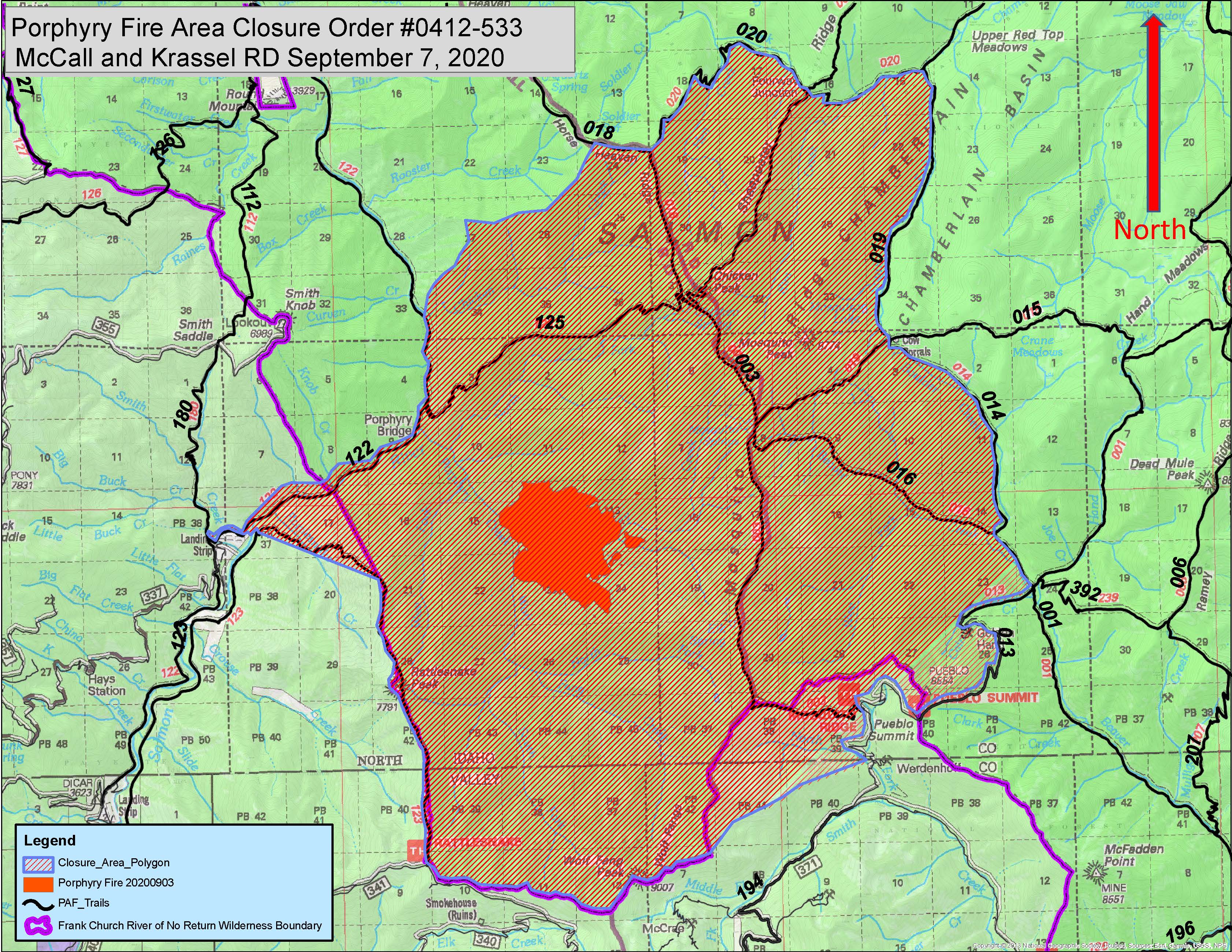
Porphyry Fire Recreation Area Closure
Related Incident:
Publication Type: Closures
Order Number: 0412-533
UNITED STATES DEPARTMENT OF AGRICULTURE FOREST SERVICE
PAYETTE NATIONAL FOREST MCCALL AND KRASSEL RANGER DISTRICTS
PORPHYRY FIRE RECREATION AREA CLOSURE
Public Safety
PROHIBITIONS:
Pursuant to Title 36 CFR 261.50 (a) and (b), the following acts are prohibited in the Area, and on the Trails described in this Order, located within the administrative boundaries of the Krassel and McCall Ranger Districts, Payette National Forest. This Order will be in effect when signed and shall remain in effect through October 15, 2020, at 00:01 AM, unless rescinded earlier by the Forest Supervisor.
1. Going into or upon the Area described below. 36 CFR 261.53(e).
2. Being on the Trails described below. 36 CFR 261.55(a).
EXEMPTIONS:
Pursuant to 36 CFR 261.50(e) the following persons are exempt from this Order:
1. Persons with a special use authorization or other Forest Service authorization specifically exempting them from the effect of this Order.
2. Any Federal, State, or local officer, or member of an organized rescue or fire fighting force in the performance of an official duty.
3. Federal or State administrative personnel in the performance of an official duty.
AREA AND TRAIL DESCRIPTIONS
The Porphyry Fire Area is closed to all public entry beginning at the Rattlesnake Trailhead in Township 21N Range 8E Section 9; continuing north along the Frank Church River of No Return Wilderness Boundary, set 50’ to the western side of the NFS Trail #123 Rattlesnake Trail, to Rattlesnake Peak;; continuing northerly along the Wilderness boundary into T22N, R8E, Section 21 and turning West/Northwesterly towards the South Fork Salmon River, set 50’ off of NFS Trail #123 Rattlesnake Trail to the last switchback on this trail before crossing the South Fork Salmon River to the Hettinger Ranch Property line located at T22N, R8E, Section 18; continuing along private property line boundary with USFS lands westerly to the junction of NFS Trail #122 and 180; continuing along the NFS Trail #122 South Fork Salmon River Trail approximately 8 miles east/northeasterly to the Chicken Creek drainage located at T23N, R8E, Section 33; continuing northeasterly along the ridgeline towards NFS Trail #018, set 50’ off of the trail all the way to the Fourway Junction at T23N, R9E, Section 16; continuing easterly following 50’ off of NFS Trail # 020 Hen Creek, to its junction with NFS trail #019 Chamberlain Creek; continuing Southerly and following the NFS Trail #019, set 50’ off the western side of this trail to the Cow Corrals junction; continuing south/southeasterly, set 50’ off of NFS Trail #014, to the junction with NFS Trail #’s 013 and 239; continuing westerly and following 50’ set off of NFS Trail #013 to the Pueblo Summit Trailhead located at T22N, R9E, Section 34; continuing south/southwesterly, paralleling the NFS Road #373 Pueblo Summit to the Idaho County, Valley County line at T22N, R9E, Section 34/T21N, R9E, Section 3; continuing along the ridgeline west/southwesterly to the Wilderness boundary at T21N, R9E, Section 7; continuing westerly along the Wilderness boundary and terminating at the Rattlesnake TH located at T21N, R8E, Section 9.
Trails
National Forest System (NFS) Trail # 122: NFS Trail # 122 is closed beginning at the junction with the NFS Trail #180 at the Hettinger Ranch and terminating approximately 8 miles downriver at Chicken Creek.
NFS Trail #125: NFS Trail #125 Porphyry Creek the entire 5.7 miles of this trail are closed, from the southern intersection with NFS Trail #122 at the Porphyry Creek Bridge, continuing east/northeasterly to the junction of NFS trails at Chicken Peak.
NFS Trail #003: NFS Trail #003 Mosquito Ridge is closed from the trailhead at NFS Road #373 Pueblo Summit Road running northerly 12.6 miles and terminating at the junction located at Fourway Junction with NFS Trail # 020 at the northern boundary of the closure area.
NFS Trail # 123: NFS Trail # 123 Rattlesnake is closed. Beginning at the trailhead located off of the Pilot Peak Lookout Access Road (NFS Road #341) traveling northerly along the ridgeline that comprises the boundary of the Frank Church River of No Return Wilderness to Rattlesnake Peak, continuing northerly along the wilderness boundary, then traveling east/northeasterly to the South Fork Salmon River, following 50’ off of the southern side of the Rattlesnake trail and terminating at the lowermost switchback on this trail where it turns southerly and heads up river across from the Hettinger Ranch.
NFS Trail #018: NFS Trail #018 Horse Heaven Trail is closed beginning at the junction with NFS Trail #020 Hen Creek and continuing 2.5 miles south to its junction with NFS Trail # 003, and 125 at Chicken Peak.
NFS Trail #019: NFS Trail #019 is closed beginning at the western junction with NFS Trail #003 Mosquito Ridge Trail and continuing 2.5 miles east to its junction with NFS Trails #014 and 015 at Cow Corrals.
NFS Trail #016; NFS Trail #016 Beaver Creek Trail is closed beginning at the junction with NFS Trail #014 Boulder Creek and continuing Northwesterly 4.33 miles to its junction with the NFS Trail #003 Mosquito Creek Trail.
The described Area and Trails are shown on the Map attached hereto as Exhibit A, and are within the McCall and Krassel Ranger Districts, Payette National Forest, Valley County, Idaho, Boise Meridian.
PURPOSE:
The Area and Trails described above are closed to public entry in order to provide for public safety during wildfire suppression activities.
IMPLEMENTATION:
This Order will be in effect when signed and shall remain in effect through October 15, 2020, at 00:01 AM, unless rescinded earlier by the Forest Supervisor.
A Map identifying the above-described Area and Trails is attached hereto as Exhibit A, and is made part of this Order.
Violation of the above prohibition(s) is punishable by a fine of not more than $5,000.00 for an individual, or $10,000 for an organization, and/or imprisonment for not more than six (6) months. [Title 16 USC 551, Title 18 USC 3571 (b)(6), Title 18 USC 3581 (b)(7).]
Further information regarding this Order may be obtained at the McCall Ranger District office in McCall, ID, 208-634-0400 or the Payette National Forest Supervisor’s Office in McCall, ID, 208-634-0700.
Done at McCall, ID this day of September 2020.
Date: 2020.09.07
:03 -06'00'

Linda L. Jackson
Forest Supervisor Payette National Forest
Digitally signed by SUSAN HOWLE