
Morning Update Sept 22
Related Incident:
Publication Type: News
CURRENT STATUS:
Wind conditions cause ash to uplift, creating clouds over the burn area. It can be expected that ash clouds will continue to form until a large precipitation event occurs. Firefighters continue to patrol and respond to smoke reports in the interior of the fire. Structure assessments have been completed, over 270 assessments were performed. Line improvement is occurring on the North perimeter of the fire, as full suppression remains an objective of the fire. Containment remains at 83%, and acreage remains at 8,224.
WEATHER / FIRE BEHAVIOR
A chance of showers and thunderstorms will remain throughout the day, producing minimal wetting rain and high wind events gusting up to 50 mph. Temperatures will continue to be warm today, reaching high 70's. Overnight recovery of conditions continues to be unsubstantial. A fire weather watch will occur Thursday. Fire behavior remains low, but large fuels continue to smolder and sustained creeping through the duff and litter layer is still occurring.
CLOSURES
The Forest has updated the area closure. The new closure area includes roads and trails within National Forest System lands south of the Bridger Bowl Ski Area and east of the Bridger Ridge Trail #513, including Pine Creek Trail #538. Popular trails such as Sypes, Middle Cottonwood, Truman Gulch, Bridger Ridge Trail and access to the "M" are now open for recreational use. Please use extreme caution when entering areas within the burn zone and continue to respect the fire closure boundary. Bridger Canyon Road is open to the public. Travelers should SLOW DOWN and watch for fire traffic.
SAFETY MESSAGE
Recreating in burn zones can be dangerous. Watch out for hazards such as falling trees, loosened soil, burned-out holes in the ground and loose boulders and logs.
Morning Update Sept 20 2020
Related Incident:
Publication Type: News
CURRENT STATUS:
Acreage remains at 8,224. Containment remains at 83%. The south side of the fire, along with large portions of the east and west flanks and a large spot fire are contained. Firefighters continue responding to smoke reports in the interior of the fire. Structure assessments continue outside of the fire area, progressing from Jackson Creek to the south and east. Over 220 structure assessments have been completed so far. The data collected will be used to document future fire risk. Resources no longer needed will demobilize and travel home or be available for reassignment.
WEATHER/ FIRE BEHAVIOR:
Cooler temperatures over the weekend with rainfall is aiding firefighting efforts. Cloudy conditions, with occasional rain showers are expected today, with a warming and drying trend to ease into the week. Winds could gust to 25 mph. Large fuels will continue to smolder and creeping is expected. Fire behavior is low, given the cooler, damp conditions.
CLOSURES/NOTIFICATIONS;
Bridger Canyon Road is open to the public. Travelers should SLOW DOWN and watch for fire traffic. The current Forest area closure includes, roads and trails to all human entry within the Bridgers, west of Hwy 86 and south of a line from Brackett Creek intersection (the Y), extending to the west through Ross Peak to the western Forest boundary. Popular trails include Middle Cottonwood, Bridger Foothills, Sypes, all Bridger Bowl trails to the ridge and all trails south of Brackett Creek and up and over Ross Peak remain closed. Trail users should refrain from attempting to run the ridge or loop Bridger Foothills trail, many connector trails remain closed. The Forest is in the process of re-evaluating the current closure.
SAFETY MESSAGE:
There is a temporary flight restriction in place over the fire area. Wildfires are a NO DRONE ZONE. If you fly, we can't. Flying a drone near a wildfire can shut down all air operations.
The Gallatin County Emergency Management Office encourages all residents to be prepared for future emergencies, by signing up to receive emergency notifications through the Community Notification System. Information can be found at https://www.readygallatin.com/public-warning/community-notification-system/.
Personal responsibility and prevention of the next ignition is of utmost importance in preventing the next wildfire. Take extra precaution when having campfires; put them dead out and cold to the touch before leaving. Refrain from parking vehicles on dry grass and make sure all power equipment is in good working condition.Bridger Foothills Fire Final Morning Update
Related Incident:
Publication Type: News
Current Status:
This will be the final update for the Bridger Foothills Fire. Updates will occur on an as needed basis from here on out. On Friday, October 2 (today) the fire transitioned back to the local district and Type 4 Incident Commander Paul Monforton. Resources on the fire will continue to grid, patrol and extinguish any remaining smokes. Gridding includes firefighters spreading out in a linear fashion and searching out hot areas, stump holes or remaining root systems that may be holding heat. Personnel have also placed water bars to help control erosion on the Bridger Ridge Trail, these efforts will occur again in the spring. Starting today, heavy equipment will be operating within the burn zone. Please respect the current closure.
Weather / Fire Behavior
Dry weather conditions will continue, with temperatures remaining in the 70's dropping to 40's overnight. Winds generally 5-10 with gusts to 15 mph. No precipitation is forecasted.
Closures:
The Forest's area closure includes roads and trails within National Forest System lands heading south of the Bridger Bowl Ski Area and east of the Bridger Ridge Trail #513, including Pine Creek Trail #538. All other trails are open. The Bridger Ridge Trail and M trails are open. Please use extreme caution when entering areas within the burn zone and continue to respect the fire closure boundary. Bridger Canyon Road is open to the public. Travelers should SLOW DOWN and watch for fire traffic.
Safety Message
While the weather may be getting cooler, fire season is not over. If you are using a recreational fire, make sure it is DEAD OUT and cold to the touch before leaving your campsite. Fuels in the area remain dry and receptive to ignitions. Be alert and careful while recreating in or near a burn zone. There are tree felling operations going on along the edge of the burn. Strong winds can cause fire damaged trees to fall over. Stay on trail, and try to move through the area as quickly as possible to avoid exposure to hazards.
Resources for Bridger Foothills Residents Impacted by Fire
Related Incident:
Publication Type: News
Resources for Bridger Canyon Residents
(1) Resources for Home Preparation/Mitigation:
- Ready Set Go Montana – Attached PDF Guide
- FireSafe Montana – Home Owners Resources
- https://firesafemt.org/home-and-landowners
- DNRC Wildfire Preparedness Site Visit
- http://dnrc.mt.gov/divisions/forestry/fire-and-aviation/fire-prevention-and-preparedness/home-fire-risk
(2) Resources for Post- Fire Flooding:
- DNRC Floodplain Management
- http://dnrc.mt.gov/divisions/water/operations/floodplain-management/disaster-and-recovery
- http://dnrc.mt.gov/divisions/water/operations/floodplain-management/insurance
(3) Resources for Post – Fire Forestry Assistance:
- DNRC Forestry Assistance Program
- http://dnrc.mt.gov/divisions/forestry/forestry-assistance/forest-stewardship
- Contact Chuck Barone to discuss property assessment and planning for rehabilitation and recovery efforts on private land.
Chuck Barone - DNRC Service Forester (406) 559-4507
Bozeman Unit - Central Land Office
2273 Boot Hill Court,
Suite 110
Bozeman, MT 59715
- Contact Craig Campbell if your property was damaged due to suppression efforts during the Bridger Foothills Fire by fire personnel and equipment.
Craig Campbell – DNRC Bozeman Unit Manager
(406) 556 – 4507
(4) Resources for Post – Fire Stream Impacts:
- Gallatin Conservation District
- http://gallatincd.org/?page_id=14
(406) 282-4350
Sarah@gallatincs.org
- Department of Environmental Quality (DEQ)
- http://deq.mt.gov/Water/Resources/
Bridger Foothills Fire Update Sept 28 2020
Related Incident:
Publication Type: News
Fire Stats: Location: 3 mi NE of Bozeman, MT Start Date: September 4 Size: 8,224 Percent Contained: 83% Cause: Lightning Total Personnel: 23 Engines: 1 Helicopters: 1 Water Tender: 0
Bridger Foothills Fire started on an extremely dry and windy Friday prior to Labor Day. Initial attack resources responded in force, but given weather and fuel conditions the fire quickly spread. A frontal passage Saturday, September 5 pushed the fire to over 7,000 acres. The fire has shown minimal growth in recent days & suppression repair continues.. No significant weather hazards are expected over the next week. Temperatures are on the chilly side this morning, particularly in valley locations with light winds. Firefighters will continue to patrol, mop up, and look for remaining smokes. Skies will remain mostly clear. Expect breezy west to northwest winds gusting 15 to 25 mph during the afternoon. A weak cold front is expected on Wednesday, bringing temperatures back into the 60s for North- central Montana. Otherwise, expect consistent high temperatures in the lower 70s and lows near 40 all week.
Current Status:
No significant weather hazards are expected over the next week. Temperatures are on the chilly side this morning, particularly in valley locations with light winds. Firefighters will continue to patrol, mop up, and look for remaining smokes. Skies will remain mostly clear. Expect breezy west to northwest winds gusting 15 to 25 mph during the afternoon. A weak cold front is expected on Wednesday, bringing temperatures back into the 60s for North- central Montana. Otherwise, expect consistent high temperatures in the lower 70s and lows near 40 all week.
Weather / Fire Behavior:
Fair weather prevails throughout the week. Temperatures will remain near, to above average, with highs in the 60s and 70s. Some areas could see moderate wind gusts to 25 mph during the afternoon hours. Fire behavior remains low, with no expected growth
Closures:
The Forest's area closure includes roads and trails within National Forest System lands south of the Bridger Bowl Ski Area and east of the Bridger Ridge Trail #513, including Pine Creek Trail #538. All other trails are open. Please use extreme caution when entering areas within the burn zone and continue to respect the fire closure boundary. Bridger Canyon Road is open to the public. Travelers should SLOW DOWN and watch for fire traffic.
Safety:
Be careful. Be watchful. There are tree felling operations going on along the edge of the burn. Strong winds can cause fire damaged trees to fall over. Be cautious when recreating in a burn zone, stay on the trail, and try to move through the area as quickly as possible to avoid exposure to hazards.
Anothe
gradual warming and drying trend begins Monday with clear weather predicted through much of the week. High temperatures are forecast to be in the 60s. No precipitation expected for the week.
Florida to Montana
Related Incident:
Publication Type: News
Florida to Montana
Lending a Hand to Neighbors in Need, During the Fire Season and Beyond

Bozeman, MT - FNF – The National Forests in Florida and the Flathead National Forest, along with most of the National Forests in Idaho and Montana, have a long-standing agreement, helping out across jurisdictions and fire seasons. “Most years firefighters from the Flathead, Custer Gallatin and a variety of other National Forests in Idaho and Montana come and help us burn in Florida and we make our way up here for the Montana fire season,” said Jessica Vincent, Engine Boss and crew lead for the current Florida - Flathead Crew.
This crew of 8 firefighters, known as Engine 651 is here on the Custer Gallatin National Forest, helping with the Bridger Foothills Fire. Four of the crew are from Florida and four from the Flathead National Forest in NW Montana. Joining us from each of the National Forests in Florida, the Osceola National Forest, the Apalachicola, and the Ocala Forests. The crew consists of a former beach lifeguard, an Army veteran, a Navy veteran and heavy equipment operator, another who spent years working with troubled youth, a first-year firefighter, timber strike team forestry technicians, and the son of a smokejumper, saying ‘fire is in the blood’. The crews experience ranges from first year to 19 + years in fire. Bringing all that experience together you are looking at 72 years of assorted life and fire experience coming to Bozeman, MT and working together to help our Neighbors on the Bridger Foothills Fire.
The crew is enjoying the views and topography of the Bridger Mountains we call home. A couple of the crew noted “seeing snow for the first time!” Another, Haley, her first year in fire says, “she loves the dynamic of fighting fire and being in snow.” As the seasons change here in Bozeman and the fall equinox passes us by, the crew has enjoyed the evenings and big skies of Montana with sunsets and wildlife often times coming off the line with those sunset backdrops.
Interagency Across the Nation
The Fire family is pretty small once you get involved, working across the nation and in recent examples across the world, wildland firefighters have common training protocols and come together in stressful situations to do what they are trained for. Working under the ICS system or Incident Command System, firefighters can be deployed across the nation and are quickly briefed on an area. Taking into account the particular fire, topography, fuels, weather, terrain, local factors and more.
This Florida - Flathead crew as they have heartedly been dubbed, had to acclimate to the elevation and the weather, but in many ways are enjoying the lower humidity (compared to Florida) and the cooler temperatures. The views are also making the trip an experience not forgotten. “It was pretty neat the other day getting above, in the open areas and seeing the mountains beyond,” (the Absaroka and Crazy Mountains from the crew’s viewpoint). Max, a Flathead Timber Crew Member who has also spent time in Bozeman adds “that’s one of the best things about living here in Montana, those views!”
If you see our fire crews out continuing to mop-up the Bridger Foothills Fire give them a hearty Montana welcome and sincere thank you. We’ve appreciated their hard work and hope they take in some of our local Montana living and culture while here. Stay safe out there.
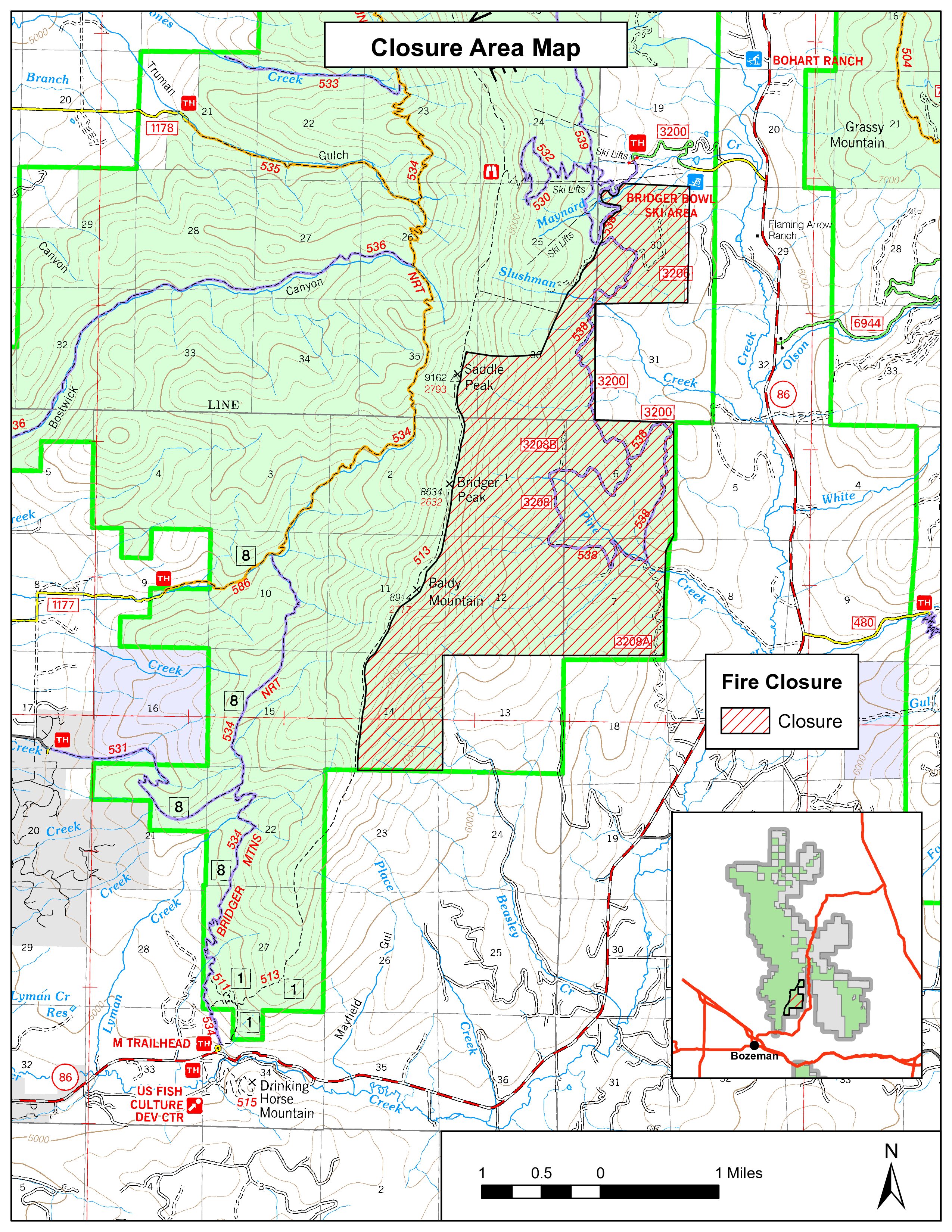
Bridger Foothills Fire Closure Order September 21
Related Incident:
Publication Type: Closures
UNITED STATES DEPARTMENT OF AGRICULTURE
FOREST SERVICE CUSTER GALLATIN NATIONAL FOREST
BOZEMAN RANGER DISTRICT – BOZEMAN, MONTANA
FOREST ORDER AREA CLOSURE – BRIDGER FOOTHILLS FIRE
For Protection of Public Health and Safety
Pursuant to 16 U.S.C. § 551 and 36 C.F.R. § 261.50(a), the following acts are prohibited on the National Forest System lands as depicted on the attached map within the Bozeman Ranger District, Custer Gallatin National Forest, within Gallatin County, Montana
PROHIBITIONS:
1. Going into or being upon an area 36 C.F.R. § 261.52(e)
AREA CLOSURE DESCRIPTION:
The closure applies to National Forest System (NFS) lands within the Bozeman Ranger District, Custer Gallatin National Forest shown in Attachment A including the following roads and trails:
#538 Pine Creek - Bridger Bowl to South
And is generally described as the National Forest System (NFS) lands south of the Bridger Bowl Ski area operating area and east of the Bridger Ridge Trail #513.
PURPOSE:
This closure is for public health and safety due to fire activity associated with the Bridger Foothills Fire.
IMPLEMENTATION:
This Order will be in effect on the date signed and shall remain in effect until October 15, 2020 or until rescinded.
EXEMPTIONS:
Pursuant to 36 CFR 261.50(e), the following persons are exempt from this Order:
1) Persons with a special use authorization or other Forest Service authorization specifically exempting them from the effect of this order.
2) Any Federal, State, or local officer, or member of an organized rescue or fire fighting force in the performance of an official duty;
3) Persons with a permit specifically authorizing the otherwise prohibited act or omission.
4) Owners or lessees of land in the area;
5) Residents in the area;
6) Any Federal, State, or local officer, or member of an organized rescue or fire fighting force in the performance of an official duty; and
7) Persons engaged in a business, trade, or occupation in the area.
VIOLATION:
Violation of these prohibitions is punishable by a fine of not more than $5,000 for an individual or $10,000 for an organization, imprisonment for not more than 6 months, or both. (16 U.S.C. §551 and 18 U.S.C. §§ 3559, 3571 and 3581(b)(7).
INFORMATION:
Further information regarding this Order may be obtained at the Bozeman Ranger District Office located at Bozeman, Montana. (406) 522-2520. Executed in Bozeman, Montana, this 21st day of September, 2020
MARY ERICKSON
Forest Supervisor
Custer Gallatin National Forest
Bridger Foothills Fire Update September 20
Related Incident:
Publication Type: News
Incident Commander Bob Culbreth, IC(T) Caleb Schreiber
INCIDENT STATISTICS:
Location: 3 mi NE of Bozeman, MT
Start Date: September 4
Size: 8,224
Percent Contained: 83%
Cause: Lightning
RESOURCES ASSIGNED:
Total Personnel: 101
Engines: 5
Structure Assessment Group
Helicopters: 2
Water Tender: 1
SUMMARY:
Bridger Foothills Fire started on an extremely dry and windy Friday prior to Labor Day. Initial attack resources responded in force, but given weather and fuel conditions the fire quickly spread. A frontal passage Saturday, September 5 pushed the fire to over 7,000 acres. The fire has shown minimal growth in recent days & suppression repair continues.
COOPERATING AGENCIES:
Gallatin County
Montana DNRC
Custer Gallatin NF
CURRENT STATUS:
Acreage remains at 8,224. Containment remains at 83%. The south side of the fire, along with large portions of the east and west flanks and a large spot fire are contained. Firefighters continue responding to smoke reports in the interior of the fire. Structure assessments continue outside of the fire area, progressing from Jackson Creek to the south and east. Over 220 structure assessments have been completed so far. The data collected will be used to document future fire risk. Resources no longer needed will demobilize and travel home or be available for reassignment.
WEATHER/ FIRE BEHAVIOR:
Cooler temperatures over the weekend with rainfall is aiding firefighting efforts. Cloudy conditions, with occasional rain showers are expected today, with a warming and drying trend to ease into the week. Winds could gust to 25 mph. Large fuels will continue to smolder and creeping is expected. Fire behavior is low, given the cooler, damp conditions.
CLOSURES/NOTIFICATIONS:
Bridger Canyon Road is open to the public. Travelers should SLOW DOWN and watch for fire traffic. The current Forest area closure includes, roads and trails to all human entry within the Bridgers, west of Hwy 86 and south of a line from Brackett Creek intersection (the Y), extending to the west through Ross Peak to the western Forest boundary. Popular trails include Middle Cottonwood, Bridger Foothills, Sypes, all Bridger Bowl trails to the ridge and all trails south of Brackett Creek and up and over Ross Peak remain closed. Trail users should refrain from attempting to run the ridge or loop Bridger Foothills trail, many connector trails remain closed. The Forest is in the process of re-evaluating the current closure.
SAFETY MESSAGE:
There is a temporary flight restriction in place over the fire area. Wildfires are a NO DRONE ZONE. If you fly, we can't. Flying a drone near a wildfire can shut down all air operations.
The Gallatin County Emergency Management Office encourages all residents to be prepared for future emergencies, by signing up to receive emergency notifications through the Community Notification System. Information can be found at https://www.readygallatin.com/public-warning/community-notification-system/.
Personal responsibility and prevention of the next ignition is of utmost importance in preventing the next wildfire. Take extra precaution when having campfires; put them dead out and cold to the touch before leaving. Refrain from parking vehicles on dry grass and make sure all power equipment is in good working condition.Bridger Foothills Fire Update September 19
Related Incident:
Publication Type: News
Northern Rockies Incident Management Team 5
Joe Sampson, Incident Commander
INCIDENT STATISTICS
Location: Custer Gallatin NF, 3 miles NE of Bozeman, MT
Start date: September 4, 2020
Size: 8,224 acres
Percent Contained: 83%
Cause: Lightning
Resources Assigned:
• Total personnel: 196
• Engines: 5
• Type 2 Hand crews: 4
• Helicopters: 2
• Water tenders: 1
SUMMARY:
The Bridger Foothills Fire started around 3 pm on September 4, 2020. Initial attack forces responded, but were unable to suppress the fire, given the extreme dry and windy conditions.
By that night the fire had grown to about 400 acres. Local resources attempted extended attack on Saturday, but a frontal passage with strong winds pushed the fire to an estimated 7,000 acres. The fire has shown minimal fire behavior on the perimeter in recent days, with interior smokes still visible. Firefighters continue to patrol, mop-up hot spots and secure the fire edge. Resource advisors are evaluating the fire area and coordinating suppression repair.
SAFETY:
There is a Temporary Flight Restriction in place over the fire area.
Wildfires are a NO DRONE ZONE. If you fly, we can't. Flying a drone near a wildfire can shut down all air operations.
COOPERATING AGENCIES:
Gallatin County
Montana DNRC
Custer Gallatin NF
CURRENT STATUS:
Acreage remains at 8,224 acres. Containment remains at 83%. The south side of the fire, a large portion of the east and west sides, and the large spot east of the fire are contained.
Northern Rockies Team 5 will transfer command of the fire to a local incident management organization, effective tomorrow morning.
Fire personnel and an engine responded to a report of a hot spot early this morning at 4:30 a.m., just south of Pine Creek along the eastern edge of the fire. The heat was interior to the fireline and did not pose a threat. Crews patrolled and "mopped-up" hot spots interior to the fire's edge on all flanks. Fire personnel and local Fire Department representatives continued to assess structures outside the fire area, progressing from Jackson Creek to the south and east. Over 220 structure assessments have been completed so far. The data collected will be used to document the fire risk for those structures in the event of future fires. Resources no longer needed are demobilizing and traveling home, as the organization downsizes over the next few days.
WEATHER/FIRE BEHAVIOR:
The fire experienced good relative humidity recovery overnight. Much cooler temperatures (low 60s) and cloudy conditions are expected today, with relative humidity in the 50-54% range. Winds associated with the cold front could gust to 20 mph in the afternoon. Smoke from other fires in the western U.S. will linger in the Bozeman area, but is expected to be somewhat less. There is a 90% chance of wetting rain, up to .1 inch. The extended forecast for next week calls for a return to warmer and drier conditions.
Large fuels will continue to smolder, and creeping fire behavior is expected in duff and lighter fuels. Expected fire behavior is low, given the cooler, damp conditions.
CLOSURES/NOTIFICATIONS:
Bridger Canyon Road in its entirety is OPEN to the public. Travelers should SLOW DOWN and watch for fire traffic, as firefighting resources remain in the area.
The Forest has modified the area closure order for National Forest System lands in the Bridger Foothills Fire area. This closes the area, roads, and trails to all human entry within the Bridgers, west of Highway 86 and south of a line from the Brackett Creek intersection ("the Y") extending to the west through Ross Peak to the western Forest boundary. Popular trails like Middle Cottonwood, Bridger Foothills, Sypes Canyon, all Bridger Bowl trails to the ridge and all trails south of Brackett Creek and up and over Ross Peak remain closed. Trail users should refrain from attempting to run the ridge or loop the Bridger Foothills trail; many connector trails are still closed. Visit the Inciweb page, Closures tab, for a detailed description and map of the modified closure.
The Gallatin County Emergency Management Office encourages all residents to be prepared for future emergencies, by signing up to receive emergency notifications through the Community Notification System. Information can be found at https://www.readygallatin.com/public-warning/community-notification-system/.
Personal responsibility and prevention of the next ignition is of utmost importance in preventing the next wildfire. Take extra precaution when having campfires; put them dead out and cold to the touch before leaving. Refrain from parking vehicles on dry grass and make sure all power equipment is in good working condition.
Bridger Foothills Fire update September 18
Related Incident:
Publication Type: News
Northern Rockies Incident Management Team 5
Joe Sampson, Incident Commander
INCIDENT STATISTICS
Location: Custer Gallatin NF, 3 miles NE of Bozeman, MT
Start date: September 4, 2020
Size: 8,224 acres
Percent Contained: 83%
Cause: Lightning
Resources Assigned:
• Total personnel: 173
• Engines: 5
• Type 2 Hand crews: 3
• Helicopters: 2
• Water tenders: 1
SUMMARY:
The Bridger Foothills Fire started around 3 pm on September 4, 2020. Initial attack forces responded, but were unable to suppress the fire, given the extreme dry and windy conditions.
By that night the fire had grown to about 400 acres. Local resources attempted extended attack on Saturday, but a frontal passage with strong winds pushed the fire to an estimated 7,000 acres. The fire has shown minimal fire behavior on the perimeter in recent days, with interior smokes still visible. Firefighters continue to patrol, mop-up hot spots and secure the fire edge. Resource advisors are evaluating the fire area and coordinating suppression repair.
SAFETY:
There is a Temporary Flight Restriction in place over the fire area.
Wildfires are a NO DRONE ZONE. If you fly, we can't. Flying a drone near a wildfire can shut down all air operations.
COOPERATING AGENCIES:
Gallatin County
Montana DNRC
Custer Gallatin NF
CURRENT STATUS:
Acreage remains at 8,224 acres. Containment remains at 83%. The south side of the fire, a large portion of the east and west sides, and the large spot east of the fire are contained. Crews were successful at gaining some containment on the northern flank, where the burn was "dirty" and left a jagged edge.
Crews patrolled and "mopped-up" hot spots interior to the fire's edge on all flanks. Fire personnel and local Fire Department representatives continued to assess structures outside the fire area, starting north of the fire and progressing southward. The data collected will be used to document the fire risk for those structures in the event of future fires. Heavy equipment will work to repair and smooth out roads and dozer lines used for the suppression operation. Resources no longer needed are demobilizing and traveling home, as the organization downsizes.
Personnel utilized an Unmanned Aircraft System (UAS) to locate hot-spots along the fire perimeter on the northern flank. The system detected an area of interior heat in a pocket of green fuel inside the fireline; crews were able to locate the specific area and address the heat.
WEATHER/FIRE BEHAVIOR:
The fire experienced moderate relative humidity recovery overnight. Slightly warmer temperatures (high 70s) are expected today, with relative humidity in the 15-19% range. Winds will increase ahead of a cold front, potentially gusting to 25 mph in the afternoon. Smoke from other fires in the western U.S. will linger in the Bozeman area, but is expected to be somewhat less today.
Large fuels will continue to smolder, and creeping fire behavior is expected in duff and lighter fuels. Expected fire behavior is low; however, potential for fire remains high, due to extremely dry fuels and near critical weather conditions. The forecast calls for much cooler weather and a chance of rain showers through the weekend.
CLOSURES/NOTIFICATIONS:
Bridger Canyon Road in its entirety is OPEN to the public. Travelers should SLOW DOWN and watch for fire traffic, as firefighting resources remain in the area.
The Forest has modified the area closure order for National Forest System lands in the Bridger Foothills Fire area. This closes the area, roads, and trails to all human entry within the Bridgers, west of Highway 86 and south of a line from the Brackett Creek intersection ("the Y") extending to the west through Ross Peak to the western Forest boundary. Popular trails like Middle Cottonwood, Bridger Foothills, Sypes Canyon, all Bridger Bowl trails to the ridge and all trails south of Brackett Creek and up and over Ross Peak remain closed. Trail users should refrain from attempting to run the ridge or loop the Bridger Foothills trail; many connector trails are still closed. Visit the Inciweb page, Closures tab, for a detailed description and map of the modified closure.
The Gallatin County Emergency Management Office encourages all residents to be prepared for future emergencies, by signing up to receive emergency notifications through the Community Notification System. Information can be found at https://www.readygallatin.com/public-warning/community-notification-system/.
With the near critical fire weather conditions, personal responsibility and prevention of the next ignition is of utmost importance in preventing the next wildfire. Take extra precaution when having campfires; put them dead out and cold to the touch before leaving. Refrain from parking vehicles on dry grass and make sure all power equipment is in good working condition.