
Please contact local organizations before making donations
Related Incident:
Publication Type: Announcement
During emergency incidents it’s a natural and generous desire to wish to help and support the responders. In order to be most effective, please check with the intended receiving organization to ensure the item(s) are needed or what would be most useful. Federal responders are well supplied with food, water, and other supplies and are not in need of donations. Organizations such as Red Cross, volunteer fire departments, etc. are good groups to support; again, please check with them prior to arriving with items. Thank you.
Related Info: Visit https://wildlandfire.az.gov/wildfire-resources for additional info on How You Can Help
Go notification for T11 Ranch Beverly Hills So of Hwy 70
Related Incident:
Publication Type: Announcement
Mescal Fire Advisory- "Go" notification for T11 Ranch and Beverly Hills South of Highway 70
The San Carlos Apache Tribal Emergency Response Commission has announced a "GO" - evacuate notification for the following areas:
- T-11 Ranch
- Beverly Hills
- Residents on the South side of US Highway 70
The Following areas remain on SET - Be Alert
- North of Highway 70
- Cutter
- Apache Gold Casino
SET - Be Alert
Know there is significant danger in your area.
Residents should consider voluntarily relocating to a shelter or with family/friends outside the affected area. Residents should avoid close contact with those who are sick and should practice public health recommendations when relocating.
Grab your emergency go kit.
Keep in mind unique needs for your family or special equipment for pets and livestock. Stay aware of the latest news and information from public safety and public health officials.
Temporary Shelters have been set up at the High Desert Middle School, Apache Gold Casino Convention Center & Pavilion. Both locations accepts pets. The Apache Gold Casino RV Park is accepting evacuees from both the Telegraph and Mescal Fires. For more information, please call: 928.475.2008
For more information on Ready Set Go, please visit https://ein.az.gov/ready-set-go
Source: San Carlos Apache Tribe Emergency Response Commission Facebook page
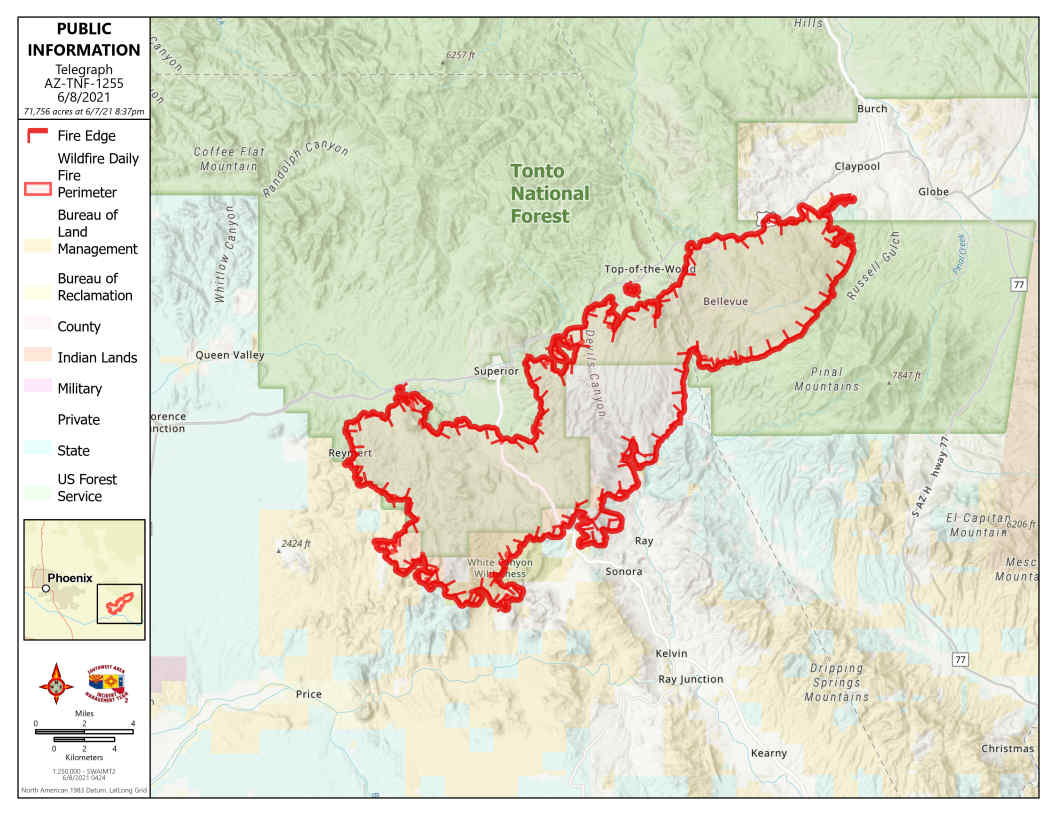
Telegraph Fire Morning Update June 8 2021
Related Incident:
Publication Type: News
Fire Information Public Phone Line: 480-608-2054
NEW Fire Information Media Phone Line: 949-573-5408
Email: 2021.Telegraph@firenet.gov/
InciWeb: https://inciweb.nwcg.gov/incident/7512/
NEW Facebook: https://www.facebook.com/Telegraphfireinformation/
Telegraph Fire Morning Update – June 8, 2021
FOR CURRENT EVACUATION INFORMATION, residents are advised to monitor Facebook pages for Pinal County Sheriff’s Office: https://www.facebook.com/PinalCountySO/ and Gila County Health and Emergency Management: https://www.facebook.com/gilacohealthem/ Notifications can change rapidly. Residents in areas affected by the fire should remain vigilant and be prepared to evacuate. Evacuation notifications are issued when danger is imminent and life threatening.
Acres: 71,756
Percent Containment: 0%
Date/Time Detected: Friday, June 4, 2021, 1:30 pm
Structures burned: 0
Number of Personnel: 741
Cause: Human, under investigation
Origin/Location: South of Superior, Arizona
Yesterday and last night firefighters and air operations worked on securing values at risk threatened by hot spots and active fire, primarily on the northeast portion of the fire, from Picket Post Mountain east to Six Shooter Canyon by building dozer and handlines, burnouts as needed and structure protection. Today the fire is expected to be active and aggressive, driven by gusty winds that could cause active runs to the northeast. Crews will continue building fire line and scout for natural barriers, roads, old fire lines and mine pits that they can tie together to stop the fire spread. Crews will also utilize burnouts to secure the fire’s perimeter.
EVACUATION SHELTERS: High Desert Middle School in Globe and Skyline High School in Mesa.
Gila County Emergency Management has activated a call center for information on sheltering if you evacuate due to wildfire: 928-910-4009 8am-5pm.
READY,SET,GO! INFORMATION: https://ein.az.gov/ready-set-go/
PINAL COUNTY EMERGENCY NOTIFICATION SYSTEM - Sign up for emergency notifications here: https://member.everbridge.net/892807736724089/login/
GILA COUNTY EMERGENCY NOTIFICATION SYSTEM - Sign up for emergency notifications here:
https://member.everbridge.net/892807736724090/login/
CLOSURE AREAS: Tonto National Forest Closure has revised its Closure Order and Map: https://www.facebook.com/TontoNationalForest/
Bureau of Land Management Emergency Fire Closure Order and Map: https://www.facebook.com/BLMArizona/
ROAD CLOSURES: Arizona Department of Transportation Interactive Map: https://az511.gov/
Check out links for new Telegraph FB page and to Operations Video
Related Incident:
Publication Type: Announcement
WE HAVE A NEW FACEBOOK PAGE. Click here to visit: https://www.facebook.com/Telegraphfireinformation/
The #TelegraphFire information you were accessing on the Tonto National Forest Facebook page is moving to a new #TelegraphFire-specific page on Facebook. The official Tonto National Forest FaceBook page will continue to post Telegraph Fire information as well https://www.facebook.com/Telegraphfireinformation/ will be the official public Facebook Page containing only verified fire information. It is monitored and an attempt is made to answer questions promptly.
Click here to watch todays Video Operations Briefing with Operations Chief Todd Able: Telegraph Fire Video Operations Briefing
Click here to visit: https://www.facebook.com/Telegraphfireinformation/Telegraph Fire Evening Update June 7 2021
Related Incident:
Publication Type: News
Fire Information Public Phone Line: 480-608-2054
NEW Fire Information Media Phone Line: 949-573-5408
Email: 2021.Telegraph@firenet.gov
InciWeb: https://inciweb.nwcg.gov/incident/7512/
Facebook: https://www.facebook.com/TontoNationalForest/
Telegraph Fire Evening Update – June 7, 2021
FOR CURRENT EVACUATION INFORMATION, residents are advised to monitor Facebook pages for Pinal County Sheriff’s Office: https://www.facebook.com/PinalCountySO and Gila County Health and Emergency Management: https://www.facebook.com/gilacohealthem Residents in areas affected by the fire should remain vigilant and be prepared to evacuate.
Acres: 61,211
Percent Containment: 0%
Date/Time Detected: Friday, June 4, 2021, 1:30 pm
Structures burned: 0
Cause: Human, under investigation
Origin/Location: South of Superior, Arizona
he Telegraph Fire is showing active growth today and is burning in abnormally dry and continuous surface fuels consisting of grass, cacti, and brush in low to mid-elevations with heavy loads of manzanita and oak brush on the upper slopes. Firefighters worked today to protect the values at risk within the Oak Flat Campground, Top-of-the-World, Pinto Valley Mine infrastructure, as well as communities of Miami, Claypool and Central Heights. Additional crews focused on keeping the fire south of U.S. Route 60.
EVACUATION INFORMATION: At the time of this release, these areas have received notifications:
The following areas in Gila County are in “GO!” mode: Miami south of US 60 from Dairy Canyon to Mackey’s Camp; Lower Central Heights -Russell Road from Coyote Trail through Russell Gulch; Ice House Canyon, Kellner Canyon, and Six Shooter Canyon (from the Community Center south); and the east side of El Capitan.
Gila County areas in “SET-Be Alert” status: Claypool on the south side of Highway 60 from the 60/188 jct. to Miami, Central Heights area between the188 jct. to De Marcos. This includes Central Heights, Little Acres, Miami Gardens and Copper Country Mobile Home Park, South Globe, all areas south of Hwy 60 and Hwy 70 from De Marcos to the70-77 jct., West side of El Capitan and Dripping Springs.
Last night the Gila County Sheriff’s Office issued a “GO!” notification for Miami-area residents west of Miami town limits and a “SET-Be Alert” notification for Miami, all Claypool residences on the south side of Hwy 60 from 60/88 jct. west through Miami, Little Acres, Russell Rd./Russell Gulch, and Cobre Valley Medical Center. Top-of-the-World -and Oak Flat Campground remain in “GO!”status. The Town of Superior remains in “Set-Be alert” status. Notifications are changing rapidly. Residents should remain vigilant and be prepared for evacuations.
EVACUATION SHELTERS: High Desert Middle School in Globe and Skyline High School in Mesa.
READY,SET,GO! INFORMATION: https://ein.az.gov/ready-set-go
PINAL COUNTY EMERGENCY NOTIFICATION SYSTEM - Sign up for emergency notifications here: https://member.everbridge.net/892807736724089/login
GILA COUNTY EMERGENCY NOTIFICATION SYSTEM - Sign up for emergency notifications here: https://member.everbridge.net/892807736724090/login
CLOSURE AREAS: Tonto National Forest Closure has revised its Closure Order and Map: www.facebook.com/TontoNationalForest/
The Globe Ranger District office is closed indefinitely.
Bureau of Land Management Emergency Fire Closure Order and Map: www.facebook.com/BLMArizona/
ROAD CLOSURES: Arizona Department of Transportation Interactive Map: https://az511.gov/The Gila County Animal Shelter is at capacity
Related Incident:
Publication Type: Announcement
The Gila County Animal Shelter is at capacity. They are currently working on alternative solutions at this time. Please refrain from taking your animals at this time. We will update as information changes.
Telegraph Fire Evacuations for Gila County
Related Incident:
Publication Type: News
As a result of the Telegraph and Mescal fires the Gila County Sheriff’s office, the Miami Police Department, and the Globe Police Department in coordination with the Gila County Office of Emergency Management are issuing the following Set and Go evacuation notices.The following areas have been placed in GO MODE:•Miami south of HWY 60 from Dairy Canyon to Mackey’s Camp. •Lower Central Heights – Russel Rd. from Coyote Trail through Russel Gulch. •Ice House Canyon, Kellner Canyon, and Six Shooter Canyon (from the Community Center South). •The East Side of El Capitan. GO! Evacuate. The danger in your area is imminent and life-threatening.•Residents should evacuate immediately to a shelter or with family/friends outside of the affected area. Residents should avoid close contact with those who are sick and should practice public health recommendations when relocating. •If you choose to ignore this advisement, you must understand emergency services may not be able to assist you further.•Follow instructions from emergency personnel, stay on designated evacuation routes and avoid closed areas.The following areas have been placed in SET MODE:•Claypool on the south side of Highway 60. From the 60/188 junction to Miami. •Central Heights area between the 188 junctions to De Marcos. This includes Central Heights, Little Acres, Miami Gardens, and the Copper Country Mobile Home Park. •South Globe, all areas south of Highway 60 and Highway 70 from De Marcos to the 70-77 junction. •West Side of El Capitan and Dripping Springs. Set! Be Alert. Know there is significant danger in your area.•Residents should consider voluntarily relocating to a shelter or with family/friends outside the affected area. Residents should avoid close contact with those who are sick and should practice public health recommendations when relocating. •Grab your emergency go kit.•Keep in mind unique needs for your family or special equipment for pets and livestock.•Stay aware of the latest news and information from public safety and public health officials. At this time the Red Cross Evacuation Center is located at the High Desert Middle School – 4000 High Desert Drive, Globe, AZ 85501. Casino RV and Pavilion open for RV and Camp trailers. Large animals and livestock can be relocated to the Burch Stockyards. For questions about animal sheltering please contact John Castaneda: 928-701-1028 Sincerely,Carl Melford Gila County Emergency Manager
Expanded Forest Closure Tonto NFTelegraph Fire 67
Related Incident:
Publication Type: Closures
DUE TO INCREASED FIRE DANGER AND RAPIDLY CHANGING CONDITIONS, THE TONTO NATIONAL FOREST HAS EXPANDED ITS FOREST CLOSURE FOR THE GLOBE DISTRICT
UNITED STATES DEPARTMENT OF AGRICULTURE FOREST SERVICE
TONTO NATIONAL FOREST GLOBE RANGER DISTRICT
Telegraph Fire Public Safety Closure Order
PROHIBITIONS
EXEMPTIONS
RESTRICTED AREA
PURPOSE
IMPLEMENTATION
Expanded and Revised Tonto National Forest Closure Order
Related Incident:
Publication Type: News
DUE TO INCREASED FIRE BEHAVIOR AND THE MOVEMENT AND POTENTIAL MOVEMENT OF THE #TELEGRAPHFIRE THE BOUNDARIES OF THE TONTO NATIONAL FOREST SAFETY CLOSURE HAS EXPANDED. SEE THE DOCUMENT BELOW AND ATTACHED MAP OF THE NEW CLOSURE MAP
UNITED STATES DEPARTMENT OF AGRICULTURE FOREST SERVICE
TONTO NATIONAL FOREST GLOBE RANGER DISTRICT
Telegraph Fire Public Safety Closure Order
PROHIBITIONS
EXEMPTIONS
RESTRICTED AREA
PURPOSE
IMPLEMENTATION
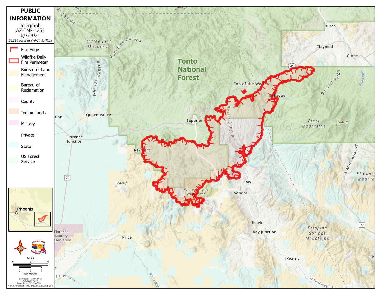
Telegraph Fire Morning Update June 7 2021
Related Incident:
Publication Type: News
Telegraph Fire Morning Update – June 7, 2021
Fire Information Public Phone Line: 480-608-2054 Fire Information Media Phone Line: 657-316-2446 Email: 2021.Telegraph@firenet.gov
InciWeb: https://inciweb.nwcg.gov/incident/7512/ Facebook: https://www.facebook.com/TontoNationalForest/
Acres: 56,626
Percent Containment: 0%
Date/Time Detected: Friday, June 4, 2021, 1:30 pm
Structures burned: 0
Cause: Human, under investigation
Origin/Location: South of Superior, Arizona
This morning a “GO!” Notification was issued for Miami Residents South of Hwy 60 from Dairy Canyon to Mackey’s Camp. This does not include Claypool.
Dry grasses and manzanita brush are burning actively after dark due to night-time downslope winds. Last night, fire crews remained active, monitoring the fire, continuing burnout operations and securing the area where the fire crossed
U.S. Route 60 yesterday in the Devil’s Canyon area.
Today firefighters will continue work to keep the fire south of US 60, west of State Route 77 and protect local communities and other values at risk.
EVACUATION INFORMATION: This morning a “GO!” was issued for Miami residents South of US 60 from Dairy Canyon to Mackey’s Camp. Last night the Gila County Sheriff’s Office issued a “GO!” notification for Miami area residents west of Miami town limits and a “SET-Be Alert” notification for Miami, Claypool, parts of Central Heights and the Cobre Valley Regional Medical Center. Top-of-the-World and Oak Flat Campground remain in “GO!” status. The Town of Superior is currently in “SET-Be Alert” status.
Pinal County Sheriff’s Office: https://www.facebook.com/PinalCountySO
Gila County Sheriff’s Office: https://www.facebook.com/Gila-County-Sheriffs-Office-641987809193824 Evacuation Shelters: High Desert Middle School in Miami and Skyline High School in Mesa.
READY,SET,GO! INFORMATION: https://ein.az.gov/ready-set-go
PINAL COUNTY EMERGENCY NOTIFICATION SYSTEM: Sign up for emergency notifications here:
https://member.everbridge.net/892807736724089/login
CLOSURE AREAS: Tonto National Forest Closure has revised its Closure Order and Map: https://www.facebook.com/TontoNationalForest/
Bureau of Land Management Emergency Fire Closure Order and Map: https://www.facebook.com/BLMArizona/
ROAD CLOSURES: Arizona Department of Transportation Interactive Map: https://az511.gov/