
Update on Marsh Creek Fire 09 07 2024
Related Incident: Marsh Creek
Publication Type: News
Crews continue to remove hazardous fuels between the fire and private property in the Canyon Creek community, which is located approximately 3 miles east of the fire. So far crews have been successful removing fuels in the North Fork of the Prickly Pear drainage and McQuithy Gulch. Additionally, crews have begun fuels work in the South Fork of Poorman drainage, located approximately 3 miles northeast of the fire. As this work begins, crews and equipment remain staged in North and South Fork of Prickly Pear Road as well as McQuithy Gulch. Other areas further from the fire have been identified for treatment, if needed based on fire activity, include the South Fork of the Prickly Pear drainage and Marsh Creek road.
The fire is burning in remote, rugged terrain with little to no access for firefighting resources. These areas pose challenges in responding to potential medical emergencies, jeopardizing the safety and well-being of firefighters and other responders. Crews continue to be focused on the nearest identified critical value at risk, homes closest to the fire, primarily on the northeast, eastern and southeastern sides, and will continue to adjust tactics if the fire behavior increases.
Fire behavior is anticipated to be active this afternoon based on predicted weather—temperatures in the low 80s, relative humidity levels in the mid-teens and winds at about 10 mph—smoke will be visible.
Huckleberry Ridge Fire Update 09 07 2024
Related Incident:
Publication Type: News
Huckleberry Ridge Fire
Daily Update
September 7, 2024
Reported: September 4th at 3:45 p.m. | Size: 343 acres | Cause: Under investigation
Total Personnel: 230| Engines/Tenders:15 | Hand Crews: 8
Safety: Please be aware that hunting season has started, and many people are out in the woods. For anyone hunting, please stay out of the fire area and be aware there is substantial firefighting activity in the area with a lot of vehicle traffic.
Update: The Huckleberry Ridge Fire is burning eight miles from the nearest structure and eleven miles from the nearest community. No infrastructure is at risk at this time. The fire acreage was moved to 343 acres due to the most current aerial mapping of the fire area done this morning. Crews continued monitoring the fire overnight. There was continued fire growth throughout area burning through steep terrain, especially along the southwest side of the fire near the East Fork Chehalis River. Crews will continue to look for a solid place for roads, handline and dozer line to help box in the fire.
More resources arrived this morning including another engine strike team and a hot shot hand crew. These crews will be used to help with spread out resources covering more ground around the fire perimeter. The fire still has air resources assigned and they are actively flying the fire.
Objectives for Today: Crews will continue to scout for opportunities to slow and stop the spread of the fire. They will be working to anchor around the edges of the fire, securing it from forward progression. Hand crews will continue to work where the terrain is inaccessible for heavy equipment and in other areas, we will cut in dozer lines where it is safe to do so.
Evacuations: There are still no evacuations, but we continue to ask that the community stay out of the area of the fire, be alert, and stay aware of the danger that exists in your area.
Closures: No road or trail closures.
Weather: Today you may see some fog and hazy clouds in the area. There is also an air quality alert this morning. Temperatures may reach into the mid-80’s today with some light variable winds.
Air Space Restrictions: A Temporary Flight Restriction (TFR) is in place over the fire. If you fly, we can’t.
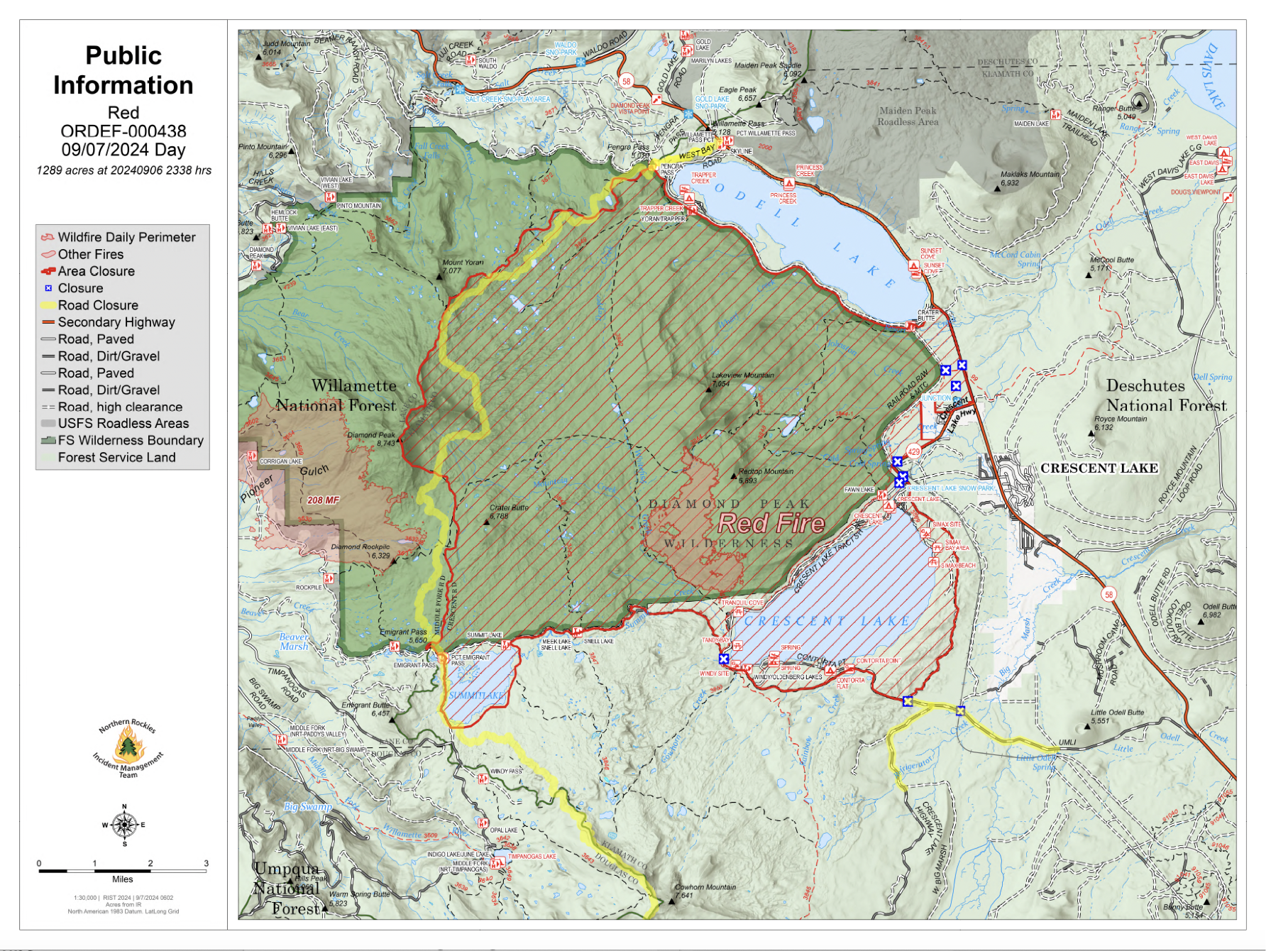
Septmber 7 2024 Red Fire Daily Update 09 07 0024
Related Incident: Red Fire
Publication Type: News
Size: 1,289 acres Location: 5 miles west of Crescent Lake Junction, OR County: Klamath
Start Date: July 17, 2024 Cause: Lightning Containment: 0% Total Personnel: 97
Activities – There was increased fire activity yesterday due to critical fire weather conditions and instability from a storm cell that moved over the area in the early evening. An overnight infrared flight mapped the fire at 1,289 acres. The fire is backing downslope into the vicinity of the Whitefish Creek Trail. Today, firefighters will continue to monitor and secure the area along the trail. Structure protection equipment remains in place along Crescent Lake. The Red Fire and Willamette Complex Fires - South incident management teams and forest leadership for the Deschutes and Willamette National Forests are coordinating, and we are monitoring the nearby 208 Fire to the west of the Cascade crest.
Strategy – A full suppression strategy is being implemented utilizing indirect tactics, shaded fuel breaks, structure protection equipment, trails, and hose lays. When the fire started, an assessment by the initial attack incident commander, local fire managers and forest staff determined the risk to responders was too great to continue with direct attack due to a lack of escape routes and safety zones, snag hazards, and firefighter safety issues in the remote location. Firefighters are continually reevaluating the safest, most effective suppression strategy based on changing weather, fuel conditions, and fire behavior. Firefighter and public safety remain the incident management team’s highest priority in managing this fire.
Closures – To provide for the safety of firefighters, equipment operators, and the public, the Deschutes National Forest emergency closure around Crescent Lake and in the Diamond Peak Wilderness is still in effect. Forest Service Road 60 is closed, and road guards have been posted for public safety. The emergency closure is being reevaluated daily as conditions continue to change. More closure information is available at: https://www.fs.usda.gov/alerts/deschutes/alerts-notices/?aid=89091.
The Pacific Crest Trail (PCT) is closed from north of Windigo Pass (Mile 1883.5) to Highway 58 (Mile 1909.5). The previous PCT detour around the fire has been decommissioned as of noon on September 4. Currently there is not a detour around the closure. A map displaying the PCT closure can be viewed on the Pacific Crest Trail Association’s (PCTA) website at: https://closures.pcta.org/closure/Mr02blDvEwX1SJ9h1H49.
The 2024 season for commercially harvesting Matsutake mushrooms opened for the Deschutes National Forest is open and will close November 4, 2024. The emergency fire closure impacts certain harvesting locations.
Incident Weather, Fire Behavior, and Smoke – Temperatures and relative humidity will again reach critical values today. Temperatures will be 80 to 85 degrees and relative humidity is forecasted to drop below 20% during the day. There is a threat of thundershowers again this afternoon with limited rainfall and gusty outflow winds. As warm and dry weather prevails, vegetation moisture will continue to drop making more fuel available and increasing surface fire activity. Active surface fire spread can be expected. Lower temperatures and high relative humidity are expected tomorrow with a cooling trend beginning on Monday.
Evacuations – The WILDFIRE! Level 1 – BE READY to Evacuate notice issued by Klamath County Emergency Management for Crescent Lake, Odell Lake, and Crescent Junction areas remains in effect (INCENDIO FORESTAL! Nivel 1 - ESTÉ PREPARADO para evacuar de las siguientes zonas: Crescent Lake, Odell Lake, Crescent Junction). Visit www.klamathcounty.org/300/emergency-management for more information or to sign up for alerts.
Fire Restrictions – Stage 2 Public Use Fire Restrictions – which prohibit open fires, including in developed campgrounds – remain in effect for the Deschutes National Forest. The Industrial Fire Precaution Level is currently Level III “Partial Shutdown.” Visit fs.usda.gov/detail/deschutes/home/?cid=stelprdb5297376 for more information.
West Mountain Fires Daily Update Sept 7 2024 Update 09 07 2024
Related Incident: Boulder FireDollar Fire
Publication Type: News
Fire Location Size Containment Assigned Personnel Inciweb Link
Boulder 6 miles SW of Cascade 4,128 24% https://tinyurl.com/ycdfv3tv
Snag 11 miles E of Cascade 32,737 13% https://tinyurl.com/4k9dk3mu
Dollar 18 NE of Cascade 4,261 3% https://tinyurl.com/bef6r3tz
Goat 11 miles SE of Cascade 5,427 0% https://tinyurl.com/2h4a3dvr
Cause: Lighting (All Fires) Total Incident Personnel 1,009
Weather | Anticipated Fire Behavior:
As thermal belts set up, temperatures remain above normal (70s - 80s today) with low humidity (low teens). There is a small (5%) chance of an isolated thunderstorm in the afternoon and evening hours today. Any storm would likely be dry and has the potential to produce gusty and erratic winds. Current weather conditions lend themselves to more active fire behavior and spotting in the coming days. Smoke is likely to settle and remain in the area. In particular, the Goat Fire is expected to see an increase in fire activity today.
Army crews from the 14th Brigade Engineer Battalion based at Joint Base Lewis McChord are imbedded with fire crews. Yesterday there were four Army crews on the Boulder Fire and two Army crews on the Snag Fire.
Boulder Fire: “Set” and “Ready” evacuation orders are in effect. Learn more at Valley County Sheriff on Facebook.
- There was some increased activity in the Olson and Brush Creek areas yesterday, and several aircraft worked to help keep fire behavior in check. Increased activity in the drainages is expected again today.
- Crews are successfully holding the 404 Road and performing some small burning operations in that area. Conditions permitting, these operations will continue today to check northern fire spread. Firefighters will improve fire lines along the 404 Road complex and near the Willow Creek area and continue assessing structures in this area.
- Fire activity is minimal on the west, and chipping operations are taking place along the 421 Road on the east.
- Aviation resources will support efforts on the ground as weather and smoke allow.
Dollar Fire:
- The Dollar Fire continues to be checked up in the old burn scars with some minimal activity on the north side. The Black Hills Wildland Fire Module continues monitoring this fire.
Snag Fire:
- Interior pockets of unburned fuel continue to burn. The fire is slowly backing down the slope on the east side, meeting the old burn scars. Other areas of the Snag Fire are slowly creeping or displaying interior burning.
- Warm Lake Road remains open from 9 a.m. to 6 p.m. with one lane of traffic and a pilot car for individuals vetted through the Valley County Sheriff’s department. (Escort request form: www.co.valley.id.us/EscortRequest. Go slow and safely along Warm Lake Road; firefighters are working along the roadway.
- Warm Lake Rd is holding well with no threat to the line but there is still some individual tree torching along the road.
- Structure prep continues near the Warm Lake Structures, and masticators are removing fuel near the South Fork of the Salmon / 474 Road and continuing south.
- Crews are mopping up and patrolling along the 409 Rd on the southeast side and along the southwest side.
Goat Fire:
- The Goat Fire was active yesterday, growing 517 acres. There was westward advancement toward the 099 Road and eastward movement toward the Sixteen to One drainage, where it is likely to align and generate active burning and visible smoke. The Goat Fire is expected to burn actively today, potentially advancing both east and west.
- Today, firefighters will hold and improve previously built fire line along the 405 Road on the north side, and crews are scouting for indirect line options south of the fire along the 041 Road system near Middle Fork drainage.
Boise National Forest:
- Closure Order #0402-04-100 Dollar/Oro Area, Trail, and Road Closure – For Forest closure areas over the Dollar fire. For more information visit: https://www.fs.usda.gov/Internet/FSE_DOCUMENTS/fseprd1199005.pdf
- Closure Order #0402-06-60 Anderson-Bulldog-Nellie Fire Area, Road, and Trail Closure – For Forest closure areas over the Goat and Snag Fires. For more information visit: https://www.fs.usda.gov/Internet/FSE_DOCUMENTS/fseprd1201349.pdf
- Closure Order #0402-04-98 Boulder Fire Area, Trail, and Road Closure – For Forest closure areas around the Boulder Fire. For more information visit: https://www.fs.usda.gov/Internet/FSE_DOCUMENTS/fseprd1197540.pdf
Payette National Forest:
- Closure Order #0412-606 Wolf Creek Burned Area Road and Trail Closure - encompassing National Forest System Trail #560 and NFS Road #1762. For more information visit: https://www.fs.usda.gov/Internet/FSE_DOCUMENTS/fseprd1202093.pdf
- Closure Order #0412-605 Dollar Fire Area and Trail Closure - north of Warm Lake Road, west of South Fork Salmon River, east of NFS Trail #101, and south of NFS Trail #99 and #100. For more information visit: https://www.fs.usda.gov/Internet/FSE_DOCUMENTS/fseprd1201446.pdf
FIRE RESTRICTIONS
The Boise National Forest is in Stage 1 Fire Restrictions. For more information visit: Boise National Forest.
EVACUATIONINFORMATION
Valley County Sheriff’s Office is responsible for issuing and enforcing evacuation orders, and for determining the boundaries of the evacuation area. Fire managers advise the sheriff when management action trigger points have been breached.
There are currently READY, SET and GO evacuation orders in place. To stay up to date with the most current information, sign up for emergency alerts, such as evacuation notices by visiting your county’s emergency alert system:
- Valley County: https://www.co.valley.id.us/CompleteEmergencyNotificationandAlerting
- Adams County: https://public.alertsense.com/SignUp/PublicUser.aspx?regionid=1077
Review the READY, SET, GO evacuation procedure for Valley County: https://www.co.valley.id.us/ReadySetGo
ROAD CLOSURES
Warm Lake Highway Closure: Piloted access continues. Warm Lake Rd will be opened for homeowners and contractors only. You will need to be on the approved list for travel. If you have already been approved, you do not need to sign up again. To be added to the approved list please visit:
- Valley County: https://www.co.valley.id.us/EscortRequest OrCall: (208) 382-5160
- Active fire behavior continues in the area, please drive slowly, be aware of crews working in the area and watch out for debris.
- National Forest System (NFS) Road 474 is now OPEN from the Boise National Forest boundary to Warm Lake.
TEMPORARY FLIGHT RESTRICTIONS
Temporary Flight Restrictions (TFR) are in place over the Boulder, Dollar, Snag, and Goat Fires. Yesterday morning, an aircraft entered the restricted zone without authorization, temporarily grounding fire aircraft and hampering firefighting efforts. Such incidents are reported to the Federal Aviation Administration (FAA) for further review. Wildfires are a no- fly zone for unauthorized aircraft, including drones. TFRs are critical for firefighter and aircraft safety. If you fly, we can’t. For more information, visit http://knowbeforeyoufly.org.
Latest version: Sept. 7, 2024
Homestead Complex and Lane 1 Fire Update 09 07 2024
Related Incident: Lane 1 Fire
Publication Type: News
Homestead Complex and Lane 1 Fires
Update for Saturday, September 7, 2024
Northwest Complex Incident Management Team 8 has taken over management of the Lane 1 Fire from Alaska Complex Incident Management Team 1 as of 7 AM today (Saturday, September 7) along with continuing to manage the Homestead Complex. The Alaska Team 1 has reached the end of their assignment duration and will be heading home. The Lane 1 Fire is located about four miles north/northwest from two of the fires on the Homestead Complex – the No Man Fire and the Horse Heaven Fire.
Homestead Complex Fire
Start Date: July 19, 2024
Size: 11,141 acres
Containment: 60%
Personnel: 560
Location: 15 miles NE of Glide, OR
Cause: Lightning
Fire Information: https://tinyurl.com/25vkhfjp
Lane 1 Fire
Start Date: July 17, 2024
Size: 25,305 acres
Containment: 97%
Personnel: 336
Location: Approx. 16 miles SE of Springfield, OR
Cause: Lightning
Fire Information: https://tinyurl.com/29k3nnly
The recent very warm and dry weather has intensified fire activity on a number of fires within the Homestead Complex and also the Lane 1 fire (as well as much of the region). Fire managers continue directing limited resources to fires based on threats to property, infrastructure, industry, and areas with the highest probability of success while providing for firefighter and public safety.
Crews have been working to locate and contain spot fires and/or line slopovers with support from helicopter bucket drops. At the same time, large areas of these fires have been contained and mopped-up and are in “clean-up” and suppression repair stages. This work includes using crews and heavy equipment to chip and haul away forest fuels near control lines. Suppression repair groups are working to minimize the fire impacts to resources, lands, and facilities resulting from firefighting operations. Firefighters are prepared to do initial attack on any new fire starts within the delegated fire operations area and to support local fire resources.
Fire Operations Summary:
Homestead Complex Fire: On the Horse Heaven Creek Fire (2,421 acres), yesterday crews were able to construct control line around most of the spot fires that crossed the 3831 Road with a few more to get line around today. Also yesterday, with the support of helicopter bucket drops, a hotshot crew built handline around the slopover that crossed the line on the northwest flank. Firing operations were completed along the northern perimeter of the planned burnout area.
On the No Man Fire (2,072 ac., containment: 28%), crews are patrolling and mopping-up. Chipping operations are continuing and suppression repair is underway.
On the Fuller Lake Fire, the fire has progressed north and joined with the Bullpup Fire at its southern flank. The priority objective for crews is to keep fire within established control lines located to the north of the Bullpup Fire in order to prevent the fire from progressing toward critical habitat for wild steelhead (the Frank and Jeanne Moore Wild Steelhead Special Management Area). Yesterday there were multiple spots across containment lines on the southern area of Fuller Lake Fire that crews were working to contain, and will continue working on today. The southeast corner of the Fuller Lake Fire has progressed south to include approximately 500 to 100 acres of the Boulder Creek Wilderness Area; and fire has crossed dozer line on the northeast corner of the fire next to the 5851 Road. Helicopter bucket drops yesterday helped control spot fires and to moderate fire behavior. Work to reinforce control lines on the 300 and 200 roads is nearing completion. On the Bullpup Fire, crews continue improving containment lines to the north, chipping, road cleanup, patrolling and mopping-up.
Three of the seven fires on the complex have now reached 100% containment, the Salmon 33 Fire (275 ac.) on August 24, 2024, the Reynolds Butte Fire (334 ac.) on August 22, 2024, and the Lost Bucket Fire (34 ac.) on July 29, 2024. Suppression repair work will continue on the Reynolds Butte and Lost Bucket fires.
On the Lane 1 Fire (20,305 ac., containment: 97%), the suppression repair continues around the fire where control lines no longer needed for containment are returned to a more natural state. This work will also make it safer for the public once closures to public managed lands are removed.
Weather: Warm and dry conditions will continue. Temperatures will approach the 90s. Winds will light from the southeast in the AM and then become northwesterly in the PM. There remains a slight possibility of a shower or isolated thunderstorm.
Closures and Fire Restrictions:
There is one large closure impacting the Cottage Grove, North Umpqua, and Diamond Lake districts. Emergency Fire Closure ORDER NO. 06-15-24-07: https://www.fs.usda.gov/alerts/umpqua/alerts-notices/?aid=88996. On August 30, 2024, the Umpqua National Forest decreased Public Use Restrictions (PURs) to Level 2, visit https://www.fs.usda.gov/detail/umpqua/news-events/?cid=FSEPRD1202470. For more information on PURs, IFPLs, or other fire management information, visit: https://www.fs.usda.gov/main/umpqua/fire
The closure order issued by Bureau of Land Management (BLM), Roseburg District, for portions of BLM land which border the Umpqua National Forest Emergency Fire Closure north of Steamboat remains in effect: https://www.blm.gov/sites/default/files/docs/2024-07/orwa-fpo-rbg-072624.pdf
There is a Temporary Flight Restriction (TFR) over the fires. Please remember, if you fly we can’t! If a drone or other aircraft enters the air space, all firefighting aviation equipment will be grounded.
Fire Information Line: 541-208-7100 (Staffed 8 a.m. to 8 p.m.)
Email: 2024.homesteadcomplex@firenet.gov
Facebook: https://www.facebook.com/HomesteadComplexFireInfo/
Actualizacin del incendio Whisky Creek Sandstone y Blister Creek 09 07 2024
Related Incident: Whisky Creek FireSandstone Fire
Publication Type: News
Tamaño de Whisky Creek: 2,621 acres | Fecha de inicio: 20 de julio |Causa: De orígen humano |Contención 25%
Tamaño de Sandstone: 702 acres | Fecha de inicio: 5 de agosto | Causa: Rayo | Contención 75%
Total de recursos: 408 | Equipos de obreros: 7 | Camiones de bomberos: 7 | Topadoras: 3 | Maquinarias pesadas: 10 | Helicópteros: 3
Los incendios Whisky Creek, Sandstone y Blister Creek arden en un terreno escarpado y accidentado en el Bosque Nacional Mt. Hood, donde los escombros rodantes y los árboles debilitados por el fuego dificultan el trabajo de extinción.
Whisky Creek:
El viernes, los vientos del este y la baja humedad relativa resultaron en una intensidad más fuerte en el incendio, ya que el fuego estuvo ardiendo en la bifurcación principal del desague de Herman Creek en el Mark O. Hatfield Wilderness. Los encargados del incendio están implementando un plan a largo plazo al aprovecharse de la huella del incendio Eagle Creek de 2017 como barrera para impedir que el fuego crezca hacia el norte y el oeste. El fuego creció un poco en el extremo sur cerca de Tomlike Mountain. Los recursos de aeronaves apoyaron al incendio de Williams Mine.
Hoy, los bomberos estarán vigilando y patrullando a lo largo del extremo este del incendio. La niveladora continuará reparando la carretera del Servicio Forestal (FSR) 2810. Una excavadora comenzó a reparar la línea de topadoras al noreste del incendio en el área de Post Canyon.
Sandstone y Blister Creek:
Ayer, en los incendios Blister Creek y Sandstone no hubo humo ni crecimiento. En el incendio Sandstone, una excavadora la limpiará zanjas y reparará carreteras a lo largo del FSR 6320 y FSR 7015. Los bomberos vigilarán ambos incendios hoy y continuarán patrullando alrededor del perímetro del incendio. Los recursos de extinción, lo que incluye seis camiones de bomberos y dos camiones de agua, siguen disponibles para ayudar con el ataque inicial de cualquier incendio nuevo
Clima: Se ha extendido la advertencia de bandera roja hasta el sábado a las 8 p.m. por causa la baja humedad relativa y el aire inestable. Durante el fin de semana las temperaturas comenzarán a bajar y para el lunes volverán a los promedios estacionales. El humo continuará asentándose en los valles por la noche, pero se despejará por la tarde. Para ver el pronóstico de humo y seguridad, consulte: oregonsmoke.org.
Cierres: Los cierres de áreas permanecerán en el Bosque Nacional Mt. Hood, el Área Escénica Nacional Columbia River Gorge y el Condado de Hood River. Los cierres se implementan para la seguridad del público y de los bomberos; el que entre en un área de cierre puede interrumpir el trabajo de extinción y reparación de los incendios, poner en peligro vidas y propiedades, y resultar en multas. Se puede encontrar información sobre el cierre en: https://linktr.ee/whisky_creek.2024.
Seguridad: El público juega un papel importante en la prevención del próximo incendio forestal; tenga cuidado con cualquier posible fuente de incendio. Para obtener consejos de prevención, consulte: https://keeporegongreen.org. La TFR sigue vigente para ambos incendios: https://bit.ly/3T59VWv. Las restricciones contra incendios están vigentes dentro del Bosque Nacional Mt. Hood. Se puede ver más información en: https://www.fs.usda.gov/main/mthood/fire.
Coffee Pot Daily Update 09 07 2024
Related Incident: Coffee Pot Fire
Publication Type: News
Unified Command: CAIIMT15 & CAL FIRE
Fire Size: 13,252 acres
Percent Contained: 27%
Primary Strategic Control Line: 96%
Personnel: 1,362
Cause: Lightning
Start Date: Saturday, August 3, 2024, at 10:05 a.m.
Location: Southeast of Three Rivers, CA
The local Arrowhead Hotshots and two Wildland Fire Module (WFM) crews; The Inyo National Forest Mammoth WFM, and the Stanislaus National Forest Summit WFM are spiked out in the northeast section of the Coffee Pot Fire. Hotshots are trained to fight the most challenging fires, often in remote and unforgiving terrain like the area of the Coffee Pot Fire. Wildland Fire Modules are highly skilled and versatile fire crews of at least seven members that provide technical expertise to meet resource and management objectives.
Spiking out is a tactic where crews camp near the fire rather than returning to base camp daily. This ensures a reduced response time, enabling fire suppression efforts without delay. Spiking out is physically demanding, usually in very remote areas, and requires careful planning to ensure the safety and well-being of the crew members.
CURRENT SITUATION: Yesterday, the Arrowhead Hotshots, Mammoth WFM, and Summit WFM began their spike out. These crews worked to slow the spread of fire and allow firefighters to strengthen control lines. Air operations supported their efforts and dropped retardant from Horse Creek down the ridge line, working to the East Fork Kaweah River. In the area south of Cedar Flat, where fire pushed past the line, crews mopped up heat sources and strengthened existing handlines. Crews backhauled equipment along the south flank of the fire and worked deeper into the burned area to bolster their mop-up efforts. On the north flank, water tenders completed retardant application along Mineral King Road while crews reinforced control lines.
Today, firefighters will work to strengthen and complete control lines to Horse Creek. Air operations will continue to enhance suppression efforts as needed. Fire crews will mop-up along Scratch Creek and continue backhauling equipment along the South Fork Kaweah River while road repair and hazardous tree mitigation is ongoing along the south flank. In the North, air operations will be utilized to keep fire intensity low as it slowly backs down to the East Fork Kaweah River. Crews will patrol along Mineral King Road and continue mop-up in the area of Lookout Point.
WEATHER: Temperatures will be slightly lower today. Thunderstorm chances are expected to be limited to the Sierra Crest. General winds remain from the southwest, while up-canyon winds are expected to develop mid-morning.
SMOKE IMPACTS: Smoke in areas closest to the fire, Hammond, Three Rivers, and Giant Forest will continue to see the greatest smoke impacts with air quality in the MODERATE range for most of the day. Areas to the North of the fire will be in the GOOD range overall. For more information on current wildfire smoke impacts in your community, please visit AirNow.gov or fire.airnow.gov.
EVACUATION NOTICES: The Tulare County Sheriff’s Office has issued Evacuation ORDERS due to current fire conditions for Genasys zones TLC-E094-C, TLC-E094-E, TLC-E094-D, and TLC-E094-B. An evacuation ORDER, also known as a mandatory evacuation, means that all residents and visitors should leave now before the fire reaches the community. If you are unable to evacuate and require assistance, please call 9-1-1. In case of sheltering needs or questions regarding sheltering, please contact the American Red Cross at 1-800-733-2767.
The Tulare County Fire Department has also issued Evacuation WARNINGS for zones TLC-E128-B, TLC-E093-A, TLC-E093-B, TLC-E095, TLC-E127-B, and TLC-E128-A. To find your zone, please refer to: protect.genasys.com.
FIRE INFORMATION: A Public Information Officer will be at the Three Rivers Village Market daily from 10:30 a.m. to 4 p.m. to provide fire information and answer questions.
BLM AND PARK CLOSURES: The portion of South Fork Drive within Sequoia and Kings Canyon National Parks and trails accessed from the road, including the Ladybug and Garfield Grove Trails, are closed. Recreational access to the Mineral King area of Sequoia National Park is closed to the public. This applies to Mineral King campgrounds, trailheads, and area trails. All other areas of the parks are open but are likely to be impacted by varying levels of smoke and poor air quality. Park closure information is available online at nps.gov/seki. The Bureau of Land Management has also issued a closure of the Case Mountain Extensive Recreation Management Area at blm.gov/press-release.
PUBLIC NOTICE: Wildfires are a no-fly zone for unauthorized aircraft, including drones. If you fly, we can’t. For more information, visit knowbeforeyoufly.org.
Gila County Issues Set Status for Communities Around Preacher Fire 09 07 2024
Related Incident: 2024 - Preacher Fire - TNF2024 - West Fire - TNF
Publication Type: Announcement
“SET” ADVISORY FOR ALL RESIDENTS OF THOMPSON DRAW 2, TONTO VILLAGE, AND DIAMOND POINT SUMMER HOMES
FOR IMMEDIATE RELEASE
Date:09/07/2024 Time: 09:00
As a result of Fire-fighting activity on the Preacher Fire, The Gila County Sheriff's has issued a “SET” status on the Ready, Set, Go model for the following areas due to anticipated fire activity.
- Thompson Draw 2
- Tonto Village
- Diamond Point Summer Homes
Fire crews will begin firing operations on Sunday, September 8th which will be conducted along the Control Road (FS 64). Crews will be starting near Tonto Village, moving toward the
west. Crews will also be starting from the junction of FS 64 and FS 65, moving east toward Tonto Village.
Although these communities are not immediately threatened, the SET notification is a preparatory measure.
SET – Be Alert
Know there is significant danger in your area.
Residents should consider voluntarily relocating with family/friends outside the affected area. Residents should avoid close contact with those who are sick and should practice public health recommendations when relocating.
- Grab your emergency go kit.
- Keep in mind unique needs for your family or special equipment for pets and livestock.
- Stay aware of the latest news and information from public safety and public health officials.
- This might be the only notice you receive. Emergency services cannot guarantee they will be able to notify everyone if conditions rapidly deteriorate. Be SET to GO.
For more information go to https://ein.az.gov/ready-set-go
To receive emergency notifications from Gila County go to: Readygila.com/alertswarnings
In the event of an emergency, please call 911.
Recording of Middle Fork Complex Community Meeting on September 6 2024 09 07 2024
Related Incident:
Publication Type: Announcement
Recording of Middle Fork Complex Community Meeting, hosted by Great Basin Team 5 on September 6, 2024
Bear Fire Incident Update 09 07 2024
Related Incident: Bear Fire, Tahoe National Forest
Publication Type: News
Location: South of Sierra Brooks off Bear Valley Rd., Tahoe National Forest
Personnel: 913
Start Date: 9/2/2024 @ 2:00 PM
Cause: Undetermined
Size: 3,325
Percent contained: 23%
Our main goal on the Bear Fire is to protect the public with care and dedication. We're committed to ensuring the safety of both you and our firefighters while managing the fire to safeguard your forests, communities, and natural areas.
Even with changes in the weather, including stronger winds and a chance of thunderstorms, there were no major weather-related issues affecting the fire. Fire crews successfully contained the fire around the Smithneck Creek State Wildlife area, which is east of Smithneck Road and north of Dodge Canyon. The crews are working hard to gain containment on the fire’s perimeter and improve the direct fire lines. Aircraft were used for water drops throughout the day.
During the night, crews concentrated on improving the direct fire lines, moping up hot spots, and continuing suppression efforts. There will be no further aircraft in the evening.
Today, we will focus on reinforcing the existing fire lines to minimize the fire's impact on nearby communities and to increase containment. Mop-up operations will continue across the area affected by the fire.
WEATHER:
Wind with a Southwest flow is expected for the next several days with a breezy pattern throughout the area. Winds gusts may reach upwards of 20mph but are not expected into critical conditions. Temperatures will remain warm. A 5% chance of thunderstorms to the east, followed by increasing southwest winds this weekend into next week.
EVACUATIONS:
Sierra County: Evacuation order and warnings remain in effect. For an interactive map of evacuations, visit: https://protect.genasys.com/search. There is a road closure at 49 and Smithneck Road that remains.
FOREST CLOSURE:
A forest closure has been issued, For more information visit the Tahoe National Forest website at: https://www.fs.usda.gov/alerts/tahoe/alerts-notices.
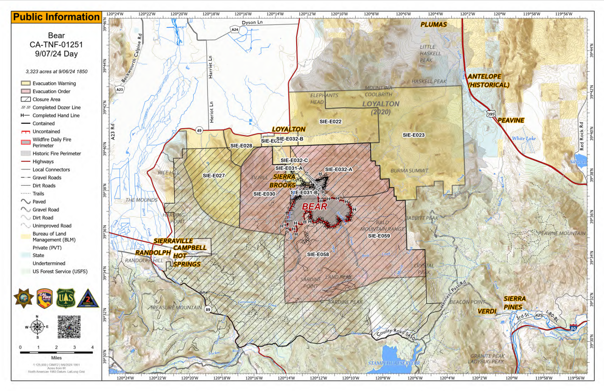
Bear Fire PIO Map for 09/07/2024