
Wapiti Fire Update September 8 2024 09 08 2024
Related Incident:
Publication Type: News
Wapiti Fire Statistics:
Size: 116,788 acres
Containment: 12%
Total Personnel: 1,477
Location: Grandjean, ID
Reported: July 24, 2024
Cause: lightning
Special Notes: Great Basin Complex Incident Management Team 7 assumed command of the fire at 7:00am Saturday morning. Great Basin Team 7 will host a public meeting for the Lowman area Sunday, Sept. 8 at 6:00 p.m. at the Lowman Fire Station. The team will attempt to livestream the meeting via Wapiti Fire Information Facebook page however, internet service is very limited. A recording will be posted after the meeting. State Highway 21 remains closed east of Lowman to Stanley from MP84 to MP130 due to wildfire activity. Highway 75 remains open. Firefighter and public safety remain the highest priority in all management decisions.
Current Situation: Crews continue to put in work in all divisions of the fire. The fire is being managed under a full suppression values-driven strategy. A values driven suppression strategy emphasizes the protection of values at risk while only placing fire personnel in locations where they will have a reasonable probability of success. Operations are being supported by aviation resources which are helping to control spot fires and suppress hot spots.
Division DD: The fire in the Sawtooth Wilderness is slowly growing towards the south and east remaining in the river drainages with rocky alpine terrain above it. Minimal resources are staffed in this division due to the limited access within the Wilderness and low fire potential.
Division HH: Crews continue to create line up to the rock scree and are anticipating areas to tie the fire into the established indirect lines. An indirect line has been completed between Iron Creek and Goat Creek.
Division KK and Structure Group East: Work continues to mop up and patrol along the entire division. The large spot east of Hwy 21 remains in patrol status. Crews are chipping cut vegetation to improve defensible space around structures and have begun repairing disturbance caused by suppression within the communities.
Division PP: Crews have completed structure prep work at Bradley Boy Scout Camp and remain staged to protect structures if needed. Fire retardant was laid down around the scout camp today to provide additional protection. Crews will also be prepping for firing operations to help keep the fire from crossing Highway 21.
Division MM: Crews continue to grid for spots, mop up, and hold established lines within the Bull Trout Lake area. An additional direct line will be constructed around the lake. Fire continues to burn on the ridge tops within the lodgepole pine and is progressing towards the north. A firing operation is planned on the northern edge of the current fire footprint, this will help crews work the fire down to Highway 21 in a predictable manner.
Division WW and Structure Group West: The Highway 21 corridor in Division WW is now the highest priority area in the fire. Structure preparation work around Sourdough Lodge and the subdivisions of Two Ravens, Ten Ax, and Seven Peaks is complete. Personnel will remain in the communities to assess structures and be in place to defend structures if needed. A mastication crew will begin work today to create a fuel break in the vicinity of the structures. The fire continues to move to the southwest towards the 8-mile creek drainage.
Division VV: Fire in this division is burning partially within the Sawtooth Wilderness and is unstaffed due to the lack of road access.
Weather, Fuels, and Fire Behavior:
Strong chance of thunderstorms in the morning, between 7 AM and 3 PM. Temperatures will reach high 70’s to low 80’s degrees with humidity remaining in the teens to twenties. There is a low chance of precipitation in this storm cycle but strong winds with gusts up to 40 mph will be present.
Expect increased activity on Tuesday, especially along the west to southwest perimeters of the fire, as dry winds come ahead of a cold front. Chances of precipitation will greatly increase going into Wednesday and Thursday, with possibilities of heavy isolated showers.
Evacuations:
For evacuation information on the Wapiti Fire, please see the Custer County Sheriff’s Facebook page at https://www.facebook.com/p/Custer-County-Sheriff-Idaho-61558947312289/ and the Boise County Sheriff’s Facebook page at https://www.facebook.com/boisecountysheriff/.
To sign up for Custer County CodeRED emergency notifications, text CUSTER to 99411 or enroll online at https://public.coderedweb.com/CNE/BF28E45537FF .
To sign up for Boise County Alert Sense emergency notification enroll online at https://public.alertsense.com/SignUp/publicUser.aspx?regionid=1163
Closures and Fire Restrictions:
State Highway 21 is still closed from MP84 to MP130 for public and firefighter safety.
A Wapiti Fire Area Closure / Forest Order: 0414-04-151 for portions of the Boise, Sawtooth, and Salmon-Challis National Forests can be found at this site: https:/www.fs.usda.gov/alerts/sawtooth/alerts-notices
Boise National Forest Stage 1 Fire Restrictions / Forest Order: 0402-00-63 can be found at this site: https://www.fs.usda.gov/alerts/boise/alerts-notices.
Sawtooth National Forest Stage 1 Fire Restrictions / Forest Order 0414-00-044 can be found at this site: https://www.fs.usda.gov/alerts/sawtooth/alerts-notices
Fire restrictions on state and private lands may be found at this site: https://www.idl.idaho.gov/fire-management/fire-restrictions-finder/.
A Temporary Flight Restriction is in place over the Wapiti Fire. Wildfires are a no-fly zone for unauthorized aircraft, including drones. If you fly, we can’t. For more information, visit http://knowbeforeyoufly.org.
For More Information:
Information Phone: 208-593-7132
Email: 2024.wapiti@firenet.gov
InciWeb: https://inciweb.wildfire.gov/incident-information/idbof-wapiti-fire
Facebook: https://www.facebook.com/wapitifireinfo2024/
Linktree: https://linktr.ee/WapitiFireInfo2024
Interactive Map: https://tinyurl.com/WapitiFireInfoMap
Sharrott Creek Fire Daily Update 09 08 2024
Related Incident:
Publication Type: News
Northern Rockies Team 3, Incident Commander Mike Behrens
Location: Three miles west of Stevensville, Montana in Ravalli County
Start Date: 8/23/2024
Cause: Lightning
Size: 3,018 Acres
Completion/Containment: 36 percent
Resources assigned: 499 people
Key messages
- Northern Rockies Complex Incident Management Team 5, Incident Commander Joe Sampson, will shadow NRCIMT 3 today and assume command of the Sharrott Creek Fire Monday at 6 a.m.
Current Status
The fire's most intense heat is on the western flank, where it's advancing slowly into the Selway-Bitterroot Wilderness, currently burning at the head of Sharrott Creek.
Firefighters continue to cool hot spots and secure the head of the Larson Creek Drainage on the northern perimeter. Crews are backhauling hoses and pumps on the northeast side. On the east perimeter, control lines are complete and reflected on the fire map as black edge. Engines will continue to patrol that line.
On the south, crews are using water to cool hot spots from the most southern point of the fire west towards the St. Mary’s Trailhead. Fire managers are optimistic about limiting the fire spread south. A rappel module remains near the St. Mary’s Trail, digging handline to tie together natural control features.
Structure protection crews are almost done backhauling sprinkler system equipment from affected neighborhoods. They also have initial attack responsibilities. A small contingent of resources continue night patrol. During the day, helicopters are supporting ground operations with water drops as needed.
Weather and Fire Behavior
Hot and dry conditions will start the day with a chance for dry thunderstorms in the afternoon. Chances of precipitation increase through the end of the week.
SMOKE
For the current smoke reports, visit https://www.airnow.gov/
EVACUATIONS, RESTRICTIONS, CLOSURES
The Ravalli Co. Sheriff’s Office has evacuation warnings in place for neighborhoods in the vicinity of the Sharrott Creek Fire. Download the Ravalli Co. Sheriff’s Office app for information or call 406-375-6650. The Bitterroot NF has an area closure from North Fork Sweeney Creek to Sweathouse Creek. See https://tinyurl.com/Sharrottclosure for the order and map. There are temporary flight restrictions (TFR) over the fire area west of Highway 93 from Bass Creek to Big Creek.
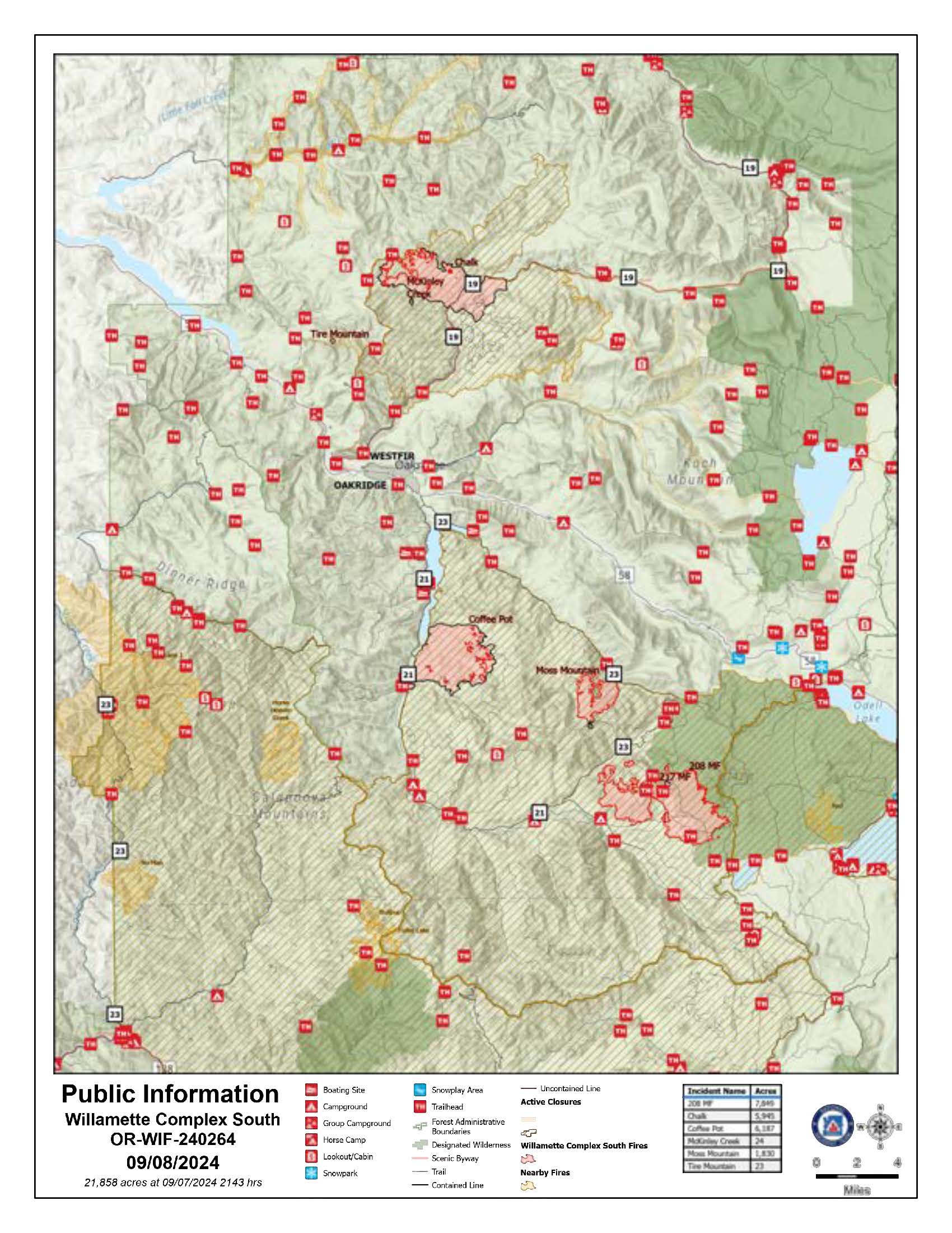
Willamette Complex South Daily Update for Sunday Sept 8th 2024 09 08 2024
Related Incident: Willamette Complex Fires - South
Publication Type: News
Willamette Complex South Update
Chalk, Coffeepot, McKinley, Moss Mountain, Tire Mountain, 208, and 217 Fires
Online: https://inciweb.wildfire.gov/incident-information/orwif-willamette-complex- fires-south
Facebook: https://www.facebook.com/WillametteComplexFires/
Email: 2024.willamettecomplex@firenet.gov Information Line: 541-208-1742
Sunday, September 8, 2024 Fire Cause: Lightning
Total Willamette Complex South Personnel: 653
Total Willamette Complex South Acres: 21,858
Resources: 3 Type 1 Hotshot crews, 5 Type 2 crews, 2 Type 2 initial attack crews, 3 helicopters, 24 engines, 4 dozers, 83 heavy equipment (masticators, skid steers, feller bunchers, etc.)
Summary
Resources provided support to the local unit on several developing incidents yesterday. A community meeting held in the evening included the following speakers: the incident commander, the fire behavior analyst, the incident meteorologist, fire operations, agency administrators, a local fire management officer and the mayor of Oakridge. The meeting recording is available on the fire’s Facebook page listed above. Today’s focus continues to be on providing initial attack support on new starts and bolstering fire line.
Chalk Fire (5,945 acres, 86% containment)
Firefighters will continue with previous day’s actions including monitoring and improving containment lines and completing control lines to the west along Forest Service Road (FSR) 1912. Similarly, monitoring of the unburned island of fuel on the northwest side of the fire continues to show declining fire activity.
Moss Mountain Fire (1,830 acres, 9% containment)
Progress continues on indirect lines to the north, west and a contingency line to the south. Crews and equipment are continuing to hold FSR 2120 to prevent fire spread south onto private timber lands. Anticipated observable fire behavior for today includes backing and flanking. Work is ongoing to secure the spot to the south of FSR 2120 into the main body of the fire. Additional indirect line construction along FSR 2120 and FSR 23 is also being prepped in anticipation of future fire spread.
208 Fire (7,849 acres, 0% containment)
Development and implementation of new primary and secondary indirect line options continue after elevated fire activity compromised previously identified lines. Fire activity continues to move towards FSR 23 to the northwest and FSR 21 ad FSR 215 to the south. Crews are strengthening these roads alongside the private timber landowners to connect line from FSR 23 to FSR 423. Felled and decked material from a nearby timber sales to the west of the fire have been protected.
Coffeepot Fire (6,187 acres, 100% contained)
McKinley Creek Fire (24 acres, 100% contained)
Tire Mountain Fire (23 acres, 100% contained)
Firefighters continue to monitor for threats to the line to maintain containment. With mop-up further along and showing reduced consumption, equipment and supplies used during suppression are being recovered from the fire area. Additionally, resource advisors are beginning to identify areas in need of repair work.
Weather and Fire Behavior
The high-pressure system and associated critical fire weather slowly left the area yesterday. Cloud cover continued which help to improve relative humidity in the area. Rain is forecasted for the area mid-week which will continue to moderate fire behavior. Expected highs for the day are in the 80s for lower and 70s higher elevations.
The Community Meeting recording is available right here on Facebook as well as on our YouTube channel: https://www.youtube.com/live/7gqAGci8cwQ?si=uUj5aBxItCnZ3F3n
Smoke Information
For local air quality information and actions to take, visit: https://fire.airnow.gov.
Closures and Fire Restrictions
For specific closure information, visit: https://tinyurl.com/WillFireClosures2024.
For current fire restrictions, visit: https://tinyurl.com/WillFireRestrictions2024
For current Temporary Flight Restrictions (TFR), visit: http://tfr.faa.gov. Wildfires are no-fly areas for unauthorized aircraft, such as drones. For more details, visit: http://knowbeforeyoufly.org/.
Closures and Fire Restrictions
- For specific closure information, visit tinyurl.com/WillFireClosures2024
- For current fire restrictions, visit tinyurl.com/WillFireRestrictions2024
- Temporary Flight Restrictions (TFR): tfr.faa.gov for up-to-date areas. Wildfires are a no-fly zone for unauthorized aircraft, including drones. For more information, visit knowbeforeyoufly.org.
Davis Fire Update 09 08 2024
Related Incident: Davis Fire
Publication Type: News
A wildfire broke out in the area of Davis Creek Regional Park around 2:30 p.m. Saturday, Sept. 7, and the park has suffered several structural losses, according to Washoe County Parks & Open Space. Washoe County has declared a state of emergency in order to draw on regional resources.
One of the structures lost to the fire was a park residence. The family was evacuated safely but the home and possessions are lost, and some pets are unaccounted for.
“Davis Creek Regional Park is home to a beloved campground and recreation area, and the loss is heartbreaking, but safety is our priority, and we are happy to report that all campers and park residents were evacuated safely,” Parks Superintendent Colleen Wallace-Barnum said. “Evacuations are in place and we ask everyone who does not need to be out on the roads to avoid the area and give fire crews room to work.”
Truckee Meadows Fire Protection District and the Humboldt-Toiyabe National Forest are in unified command in management of the fire. “Unified command” refers to a collaborative approach in incident management where multiple agencies coordinate and work together to respond to fires. Also assisting are City of Reno Fire Department, City of Sparks Fire Department, and others.
The fire is now estimated to be approximately 1,500 acres with at least 12 structures lost. A large portion of south Reno is under evacuation notice, and Virginia City Highlands is under an evacuation warning. Interstate 580 is closed in both directions between Reno and Carson City, as is Old 395 and Eastlake Boulevard.
Those in the evacuation area should not wait to leave. There is an evacuation shelter set up at the Senior Center located at 1155 E 9th Street, in Reno, and Washoe County Regional Animal Services has mobile shelters on site for small animals. Large animals can be taken to the UNR Equestrian Center in Reno or Fuji Park in Carson City for those who cannot get to Reno. Several area hotels are offering special rates for evacuees. Please call ahead to confirm availability and rates:
- The Row, Reno: $59, resort fees waived
- Nugget Casino Resort, Sparks, $100, use code EVAC24
- Best Western on Nugget Avenue, Sparks, $119, pets allowed
Those who are in an evacuation warning zone should be prepared to leave. Those who do not need to be on the road should shelter in place and avoid the area. Follow www.perimetermap.com for updates on road closures and evacuations.
Northern Nevada Public Health Issues Air Quality Advisory Due to Smoke From Davis Creek Fire 09 07 2024
Related Incident: Davis Fire
Publication Type: Announcement
Northern Nevada Public Health’s (NNPH) Air Quality Management Division (AQMD) has issued an Air Quality Advisory due to the Davis Creek Fire burning in southern Washoe County.
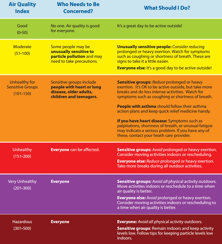
Air monitors for the most southern region have hit the “Unhealthy” range, which is 101-150 on the Air Quality Index (AQI). That means some members of the general public may experience health effects. Learn more about the AQI here.
All residents in impacted areas are encouraged to regularly monitor the air quality nearest them on AirNow.gov’s Fire and Smoke Map and limit outdoor exposure when they see or smell smoke.
More info on air quality can be found on the Northern Nevada Public Health X account.
Settings - change map background and toggle additional layers
Filter - control incident types displayed on map.
Zoom to your location
Reset map zoom and position
Could not determine your location.
Show Legend
 Wildfire
 Prescribed Fire
 Burned Area
Response
Burned Area
Response Other
Other
Davis Fire
Unit Information
Incident Contacts
Fossil Complex Evening Update 09 07 2024
Related Incident: Fossil Complex
Publication Type: News
Heat and wind push Service Fire across lines on the Fossil Complex
SPRAY, Ore. – Winds of up to 30 m.p.h. drove the Service Fire northward today, pushing it well beyond containment lines. As wind and fire intensity grew, crews withdrew from the head of the fire and relocated to continue work on cooler and safer areas of the fire. By late afternoon, the outflow winds from passing thunderstorms subsided allowing crews to reengage the fire.
A small spot fire on the Kinzua grew to 2.5 acres before crews were able to get line around it and begin securing the perimeter. The unstable winds and poor visibility today made it unsafe or aviation assets to fully engage the wind driven fire.
Elsewhere on the complex, the Holmes, Canyon and Two Cabin Fires have remained in their footprint through the day and mop up efforts progressed deeper into the black.
Critical fire weather is forecast over the next few days and will continue to test fire lines. As mop up work on the Holmes, Canyon and Two Cabins fires progresses, and additional resources arrive, more resources will become available to minimize the spread of the Service and Kinzua fires.
Fire Restrictions and Forest Closures
ODF: www.oregon.gov/odf/fire/pages/restrictions.aspx
Umatilla NF: https://www.fs.usda.gov/detail/umatilla/alerts-notices/?cid=stelprdb5382878
FIRE AT A GLANCE
Fossil Complex
Total Size: 1,342 acres
Two Cabin-251acres
Canyon-190 acres
Kinzua-96 acres
Holmes-15 acres
Service-789 acres
Containment: 0%
Cause: Lightning
Current Cost: 1.6M
All Resources
Hand Crews: 10
Engines: 6
Water Tender: 1
Dozers: 3
Skidders: 2
Skidgen: 1
Total Resources: 273
Aviation
Type 1: 1
Type 2: 2
Type 3: 3
ODF Incident Commander:
Matt Howard
Incident Management Team 2
A Division Supervisor explains occasional smoke that is routinely seen long after the main fire front has passed through an area 09 08 2024
Related Incident: Park Fire
Publication Type: Announcement
Click the link to view a Division Supervisor explains occasional smoke that is routinely seen long after the main fire front has passed through an area. These smokes, usually well interior of the containment line, are a normal facet of timber fires that often continues for weeks or more. A vast majority of those are stumps and root wads surrounded by thousands of acres of burned ground.
Copperfield Fire Daily Update 972024 09 07 2024
Related Incident: Copperfield Fire
Publication Type: News
Chiloquin, Ore. – Work done on the Copperfield Fire proved successful at holding containment through Red Flag warnings yesterday. During the night shift the IR flight detected a single hot spot which surfaced with the increase of wind. Night crews were able to focus efforts on the heat. Crews continued their success in expanding the perimeter depth of the fire in previously burned areas (black line) that are now cold and being mopped up. Containment increased to 57%.
Today’s weather calls for slightly cooler temperatures and lighter winds. The crews will take advantage of these conditions to continue their push deeper into the black areas around the fire perimeter. Focus will be on the west end, near Corbell Butte.
With the thunderstorms in the area yesterday some crews may be used for initial attack for any new fire starts from lightning. In addition, some crews will begin preparing for transition, demobing to be available for other new fires starts throughout the state.
Evacuation levels will continue to be evaluated with the increase of the fire containment. Evacuation levels are determined by the Klamath County Sheriff's Office in conjunction with fire officials and agency administrators. Current evacuation areas and levels can be found at https://www.klamathcounty.org/300/Emergency-Management.
Shoe Fly Fire Evening Update 09 07 2024
Related Incident: Shoe Fly Fire
Publication Type: News
Windy conditions prompt additional spot fires, firefighters catch and line them Saturday
MITCHELL, Ore. – Firefighting resources on the Shoe Fly Fire continued to be challenged by spot fires today, beginning as early as 6 a.m. Three new ones were found, two on the southwest side and one on the northeast corner. Firefighters spent the day lining these fires and were able to get all three of them circled with bulldozer line. Mop-up operations followed, which will continue into this evening.
Across the rest of the fire, resources continue to hold and improve lines and push forward on mop-up operations, which will continue to add toward overall containment. Tonight, crews will continue this work.
Weather systems brought short bursts of showers throughout the middle of the day, but not enough rain to make a difference on the fire. Windy conditions are expected to persist, as a Red Flag Warning issued by the National Weather Service is now extended to 11 p.m.
Temperatures heated up in the afternoon and relative humidity dropped, however chances for precipitation continue tomorrow and a predicted cold front that is expected to move into the area early next week. A chance of thunderstorms remains in the forecast for tomorrow and firefighters are ready to respond to any new reports of fire in the event of lightning strikes.
Three Oregon State Fire Marshal (OSFM) structural task forces remain engaged protecting structures near the fire. Overnight, structural firefighters assessed homes on the north side of Highway 26 in Mitchell and created mitigation plans, which day shift task forces began carrying out on Saturday. This work is precautionary and will help to protect structures if the fire moves closer toward town. This is a coordinated effort between Wheeler County Fire Defense Board, OSFM and Team 1 operations.
Evacuation notices for residents around the fire continue to be evaluated by the Wheeler County Sheriff, Wheeler County Fire Defense Board Chief, and Team 1 Operations personnel. More information on current evacuations is available at https://tinyurl.com/RAPTOR-Evacuation-Info
While there are no current road closures due to the Shoe Fly Fire, other fires nearby may be impacting travel. Check https://tripcheck.com/ for current closures and potential delays.