
Temporary Flight Restriction In Effect 03 16 2025
Related Incident:
Publication Type: Announcement
A temporary flight restriction (TFR) is in place for the Crabapple Fire area. The full details may be found at the Federal Aviation Administration website linked below. The purpose of the TFR is to provide a safe environment for firefighting aircraft to effectively work in the fire area.
As always, for any fire, do not fly drones in the fire zone. Using unauthorized unmanned aerial systems (UAS), or drones, in a fire area endangers the lives of pilots and firefighters, forcing them to ground fire suppression aircraft to avoid the potential for a midair collision. This delay further threatens firefighters on the ground and community members.
Crabapple Fire Daily Update03 15 2025
Related Incident:
Publication Type: News
Crabapple Fire Daily Update
3/15/2025
11:30pm
Size: 8640 acres
Containment: 0%
Date Started: 3/15/2025
Cause: Unknown, under investigation
The Crabapple Fire is currently an estimated 8640 acres and 0% containment. At approximately 1:30pm Texas A&M Forest Service received a request for assistance on on a wildfire in Gillespie county. Due to the high winds and low humidty, conventional tactics were proving ineffective at stopping this fire. Crews worked on structure protection and focused on life safety as a priority.
Heavy equipment was brought in to build containment line, while aircraft dropped water and retardant in an attempt to slow the spread. At nighfall the winds subsided, giving crews a chance to make progress on containment. Work will continue through the night to take advantage of the diminished fire activity.
Aircraft will return in the morning to continue working and give a better view of the extent of the fire.
Damage assessments will begin in the morning when the extent of damage can be more easliy assessed.
Structures Threathened: Approximately 50
Evacuations and closures: Hwy 16 North from the Fredericksburg City limits to Eckert Road as well as Lower Crabapple From Eckert Road into Fredericksburg
Damages and Injuries: Unknown number of homes damaged. No injuries reported at this time.
Settings - change map background and toggle additional layers
Filter - control incident types displayed on map.
Zoom to your location
Reset map zoom and position
Could not determine your location.
Show Legend
 Wildfire
 Prescribed Fire
 Burned Area
Response
Burned Area
Response Other
Other
2025 Hwy 12 MM 176 - NDSRA
Unit Information
Incident Contacts
Cottonwood Creek Fire Daily Update 03 14 2025
Related Incident:
Publication Type: News
Cottonwood Creek Fire Daily Update
3/13/2025
10:00pm
Size: 633 acres
Containment: 95%
Date Started: 3/12/2025
Cause: Equipment use, skid steer mounted saw
Fire activity remained low throughout the day. Heavy equipment worked on improving and rehabing containment lines. Engines patrolled and addressed areas of concerns. The Air Attack platform aircraft flew over the fire several times and guided the engines to remaining hotspots.
The fire has shown no growth over the last operational period and has been turned over to the local departments for the evening. The fire will likely remain at 95% containment through Saturday due to the wind event forecast for Friday.
Low humidity and gusty winds will continue tomorrow and for the foreseeable future. Please exercise caution with any outdoor activities that may cause heat or a spark.
Barring any unforseen changes, this will be the last update.
Structures: No structures currently threatened; No structures lost
Evacuations and closures: No evacuations or closures are currently in place. Please avoid the area to allow responders to work safely.
Damages and Injuries: There have been no reports of structure loss, injuries, or equipment damage.
Cottonwood Creek Fire Daily Update 03 13 2025
Related Incident:
Publication Type: News
Cottonwood Creek Fire Daily Update
3/13/2025
1:30pm
Size: 633 acres
Containment: 80%
Date Started: 3/12/2025
Cause: Equipment use, skid steer mounted saw
Last night at 9:30pm bull dozers made it completely around the fire and forward progression was stopped. Crews worked on strengthening the containment lines with engines and dozers. Local departments staffed the fire overnight.
This morning fire activity was low and no additional acreage was burned. Due to better mapping in the daylight, the total acreage was updated to 633 acres burned. Personnel have continued to mop-up the perimeter and put out any hot spots. An Air Attack platform plane was requested for a fly over at 10:00am, there were no concerns from above. Another flight is planned for 2:00pm to further assess the fire. Fire activity stayed minimal throughout the morning, allowing crews to continue to patrol and address any hotspots on the perimeter.
Low humidity and gusty winds will continue tomorrow and for the foreseeable future. Please exercise caution with any outdoor activities that may cause heat or a spark.
Structures: No structures currently threatened; No structures lost
Evacuations and closures: No evacuations or closures are currently in place. Please avoid the area to allow responders to work safely.
Damages and Injuries: There have been no reports of structure loss, injuries, or equipment damage.
Cottonwood Creek Fire Daily Update 03 13 2025
Related Incident:
Publication Type: News
Cottonwood Creek Fire Daily Update
3/12/2025
11:30pm
Size: 600 acres
Containment: 70%
Date Started: 3/12/2025
Cause: Equipment use
Texas A&M Forest Service responded to a request for assistance in San Saba County near Richland Springs. The fire started in a pecan orchard and was reportedly caused by equipment use. Strong winds carried the fire quickly through freeze cured grasses and dry brush.
Upon arrival a unified command was established between Texas A&M Forest Service and local departments. The need for aircraft was quickly identified due to heavy brush and fast moving fire. Heavy equipment began establishing containment line while aircraft made water and retardant drops at the head of the fire. Engines engaged in structure protection and strengthening fire lines created by heavy equipment.
At 9:30pm bull dozers made it completely around the forward progression was stopped. Work will continue into the night to strengthen containment lines, taking advantage of the decreased fire activity. An Air Attack platform aircraft will be over the fire at 10:00am to give the incident commander a better idea of the extent of the fire.
Low humidity and gusty winds will continue tomorrow and for the foreseeable future. Please exercise caution with any outdoor activities that may cause heat or a spark.
Structures: No structures currently threatened; No structures lost
Evacuations and closures: No evacuations or closures are currently in place. Please avoid the area to allow responders to work safely
Damages and Injuries: There have been no reports of structure loss, injuries, or equipment damage.
BDNF Spring 2025 Planned Prescribed Fire Projects 03 12 2025
Related Incident: Beaverhead-Deerlodge NF Prescribed Fire Operations
Publication Type: News
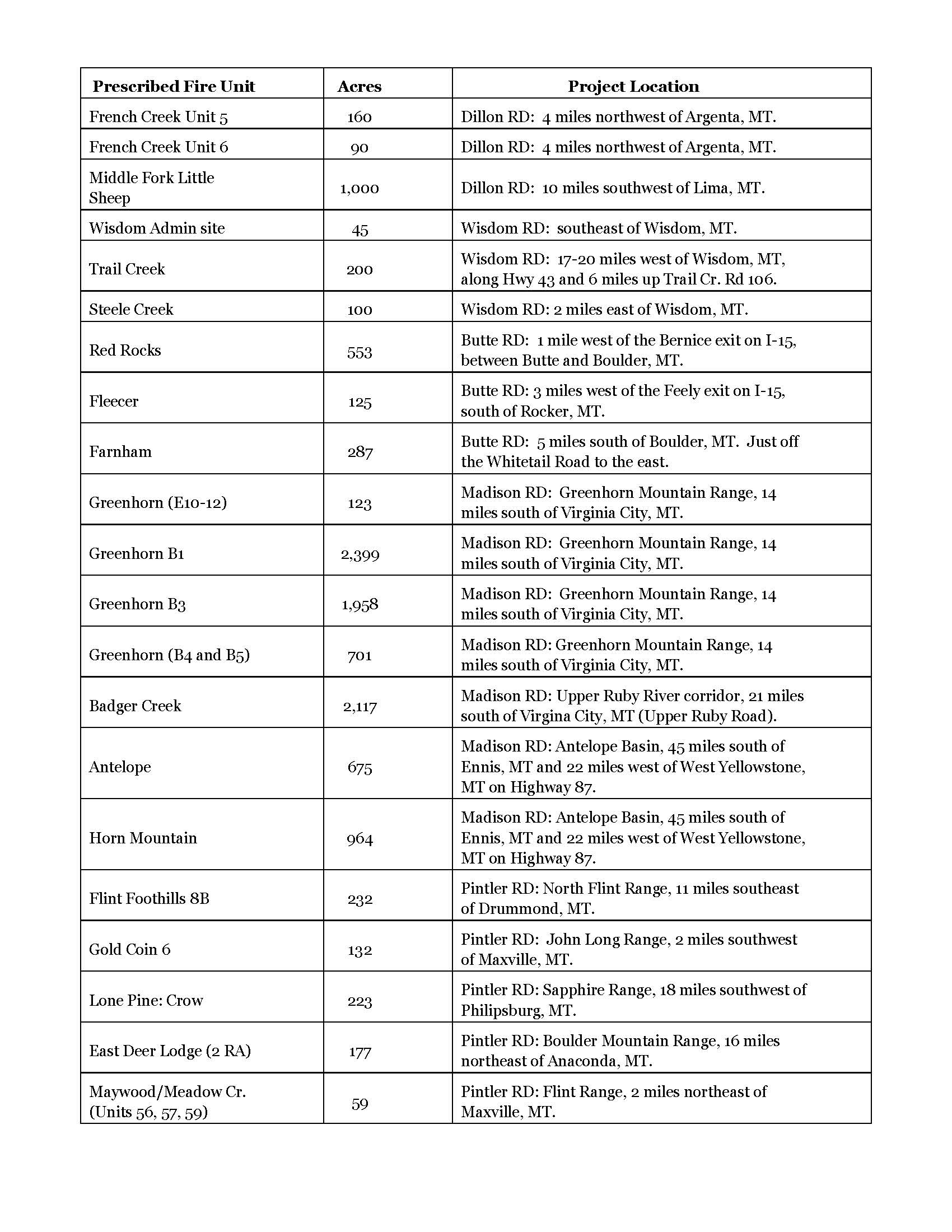
The Beaverhead-Deerlodge National Forest may implement prescribed fire projects this spring, as weather and fuels conditions allow. Prescribed fire and pile burning activities are highly weather dependent, relying on close coordination with the National Weather Service and air quality specialists to determine the best possible weather conditions to promote smoke dispersal and limit smoke impacts.
Why use prescribed fires? Prescribed fires help reduce surface fuels, increasing landscape wildfire resilience and reducing the risk of uncharacteristic wildfire effects on the landscape. In addition, they improve and maintain forest health and wildlife habitat and eliminate invasive species. The forest ecosystems in the Northern Rockies have evolved with fire, with many of them relying on periodic fires to establish and maintain forest health. “The intent behind cool season prescribed fires is to reintroduce fire as a natural disturbance agent on the landscape under conditions that are more achievable for natural resource objectives,” said prescribed fire burn boss and Fuels Program Manager for the Forest, Greg Schenk.
Benefits of prescribed burning as a forest management tool:
- Protects communities and infrastructure by reducing hazardous fuels and the risk of future high-intensity wildfires.
- Improves and supports wildlife habitat for many species on the Forest.
- Limits the spread of invasive plant species and maintains native ecosystems.
- Promotes the growth of trees, plants, and wildflowers.
- Continues the historic, natural fire regime of periodic disturbance by fire.
How do we plan? Prescribed fires are planned for various units across the Forest; however, the window of opportunity for prescribed burning is affected by several factors. Safety factors, weather conditions, air quality, personnel availability, and environmental regulations are continually monitored before implementation to determine feasibility of moving forward with the prescribed fire operations, during implementation, and after completion of the unit(s).
Prescribed fires are carefully planned and conducted in accordance with a written burn plan. Prior to implementation, Forest fire managers coordinate with local cooperators, county officials, and interagency partners. When prescription criteria are met, firefighters implement, monitor, and patrol each burn to ensure it meets forest health and public safety objectives.
Depending on the fuels and weather conditions, the prescribed fire units could be burned as early as mid-April.
Public notifications: Prior to initiating the prescribed fire or pile burning operations, fire professionals assess conditions, conduct a test burn, and notify local governments and interested publics via website postings, email, social media, and news releases. Implementation and accomplishment updates will also be posted to the Forest website, the Prescribed Fires Inciweb page, and the Forest’s Wildland Fire Information Facebook page.
Smoke: Implementation of prescribed fire activities is coordinated with the National Weather Service and air quality specialists to determine the best possible weather conditions to promote smoke dispersal and limit smoke impacts. Smoke may be visible from adjacent communities and roadways. Smoke tends to pool in lower elevations and along roadways during the evenings and early morning hours, so motorists should take note during those times.
Safety and monitoring: Trained fire professionals who have studied fire behavior and fire control techniques conduct prescribed fires in such a way to ensure the safety of the fire crew, nearby residents, and property. Schenk added, “The safety of our firefighters and the public is always our number one priority. We only conduct the prescribed fire operations if conditions allow – conditions must be just right on the ground, as identified in the corresponding plans.”
For more information about these projects, please visit the Beaverhead-Deerlodge National Forest website or our Prescribed Fire page on Inciweb and follow us on our Wildland Fire Information Facebook for updates. Contact the B-D Forest Fire PIO, Terina Hill, at (406) 683-3920, or the B-D Fuels Program Manager, Greg Schenk, at (406) 683-3870, for additional information.
Prescribed Fire Updates 03 11 2025
Related Incident: Mendocino NF Fall 2024/Spring 2025 Prescribed Fire Projects
Publication Type: News
This week Grindstone District firefighters are continuing to burn piles in the Letts Lake basin, pending favorable weather conditions. Firefighters will attempt ignitions on 65 acres today.
On the Upper Lake District firefighters were unsuccessful yesterday burning in the Bartlett Springs area due to high winds. That prescribed burn has been postponed until next week when conditions look more favorable.
All prescribed fire operations are carefully monitored, and firefighters will conduct patrols following burning operations.
More information about Mendocino National Forest’s prescribed fire operations is available online.
Settings - change map background and toggle additional layers
Filter - control incident types displayed on map.
Zoom to your location
Reset map zoom and position
Could not determine your location.
Show Legend
- Wildfire
- Prescribed Fire
- Burned Area
Response
- Other
2025-Route 13 Fire-SDCRA
Unit Information
Incident Contacts
March 11 Slowey Campground Pile Burn 03 10 2025
Related Incident: Lolo National Forest Prescribed Fire Operations
Publication Type: Announcement
**Postponed due to weather and fuel conditions**
Superior Ranger District: Firefighters will burn piles (one acre) at the Slowey Campground located 6.5 miles north west of Superior. Smoke may be visible from Interstate 90.
Prescribed fire is implemented in compliance with Montana air quality standards and coordinated with the Montana Department of Environmental Quality and the appropriate county health departments to minimize the impacts of smoke.