
Big Ridge Fire Daily Update March 29 03 29 2025
Related Incident: Big Ridge Fire
Publication Type: News
March 29, 2025
Acres: 1,936 acres Start Date: 03/22/2025
Location: Clayton, GA Personnel: 166
Containment: 0% Fuels: Timber
Resources: 8 crews | 6 engines | 2 dozer | 1 helicopter
Highlights: Reduced fire activity is expected today on the Big Ridge Fire because of higher humidity and reduced winds. On Friday, the fire crossed the Bartram Trail near Flat Top, but airtankers kept it from making progress. On the south side, the fire is being held along Hoods Creek. There will be a virtual public meeting today from 12-1 p.m. at https://meet.google.com/qcj-ukgz-mcf or by phone at 440-482-1399, PIN 359 161 763#.
Fire Activity: Today firefighters will be constructing direct line on the part of the fire that crossed the Bartram Trail near Flat Top. On the north side of the fire, crews will be completing handline from Beegum Gap to Hale Ridge Road. Once this line is completed, they will be looking for opportunities to construct direct line on the fire’s edge on the east side. On the southwest side of the fire, crews will be constructing direct line from Walnut Creek to Flat Top following Hoods Creek. Firefighters are also scouting and constructing secondary control lines in case these primary control lines are compromised.
The U.S. Forest Service Law Enforcement and Investigations is seeking information regarding the circumstances around the cause of the Big Ridge Fire. If anyone was in the area on March 22, 2025, and observed suspicious activity please call the Georgia Forestry Commission Arson Hotline 1-800-428-7337.
Weather: Today’s forecast calls for 70 degrees and minimum relative humidity of 40%. Winds will be southeast with sustained speeds of 10 mph and gusts of 15-20 mph. On Sunday there is an 80% chance of showers which continues into Monday. Smoke levels will increase from evening through the morning in the valleys.
Evacuations: None.
Closures: A closure order is in place for the vicinity of the Big Ridge Fire. For details visit https://inciweb.wildfire.gov/incident-closures/gachf-big-ridge-fire
More Information:
Facebook: https://www.facebook.com/ChattOconeeNF
Email: 2025.BigRidge@firenet.gov
Fire Information: 770-530-3950
Inciweb: https://inciweb.wildfire.gov/incident-information/gachf-big-ridge-fire
Pintler Ranger District Rx Fire Operations Spring 2025 03 28 2025
Related Incident: Beaverhead-Deerlodge NF Prescribed Fire Operations
Publication Type: Announcement
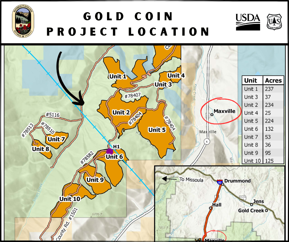
The Pintler Ranger District has developed prescribed fire implementation plans for the following units:
Flint Foothills - 11 miles southeast of Drummond
Gold Coin - 2 miles southwest of Maxville
Lone Pine - 18 miles southwest of Philipsburg
East Deer Lodge - 16 miles northeast of Anaconda
Maywood/Meadow Creek - 2 miles northeast of Maxville
Madison Ranger District Rx Fire Operations Spring 2025 03 28 2025
Related Incident: Beaverhead-Deerlodge NF Prescribed Fire Operations
Publication Type: Announcement
The Madison Ranger District has developed prescribed fire implementation plans for the following units:
Greenhorn - 14 miles south of Virginia City
Badger Creek - 21 miles south of Virginia City (Upper Ruby Road)
Antelope - 45 miles south of Ennis, along Highway 87
Magic Feather Update 03 28 2025
Related Incident: Magic Feather Prescribed Burn
Publication Type: Announcement
Crews will continue to patrol and secure the burn perimeter today and into the weekend. Light smoke may be visible. Over the burn area there is a chance of rain tonight and snow into the weekend.
Wisdom Ranger District Rx Fire Operations Spring 2025 03 28 2025
Related Incident: Beaverhead-Deerlodge NF Prescribed Fire Operations
Publication Type: Announcement
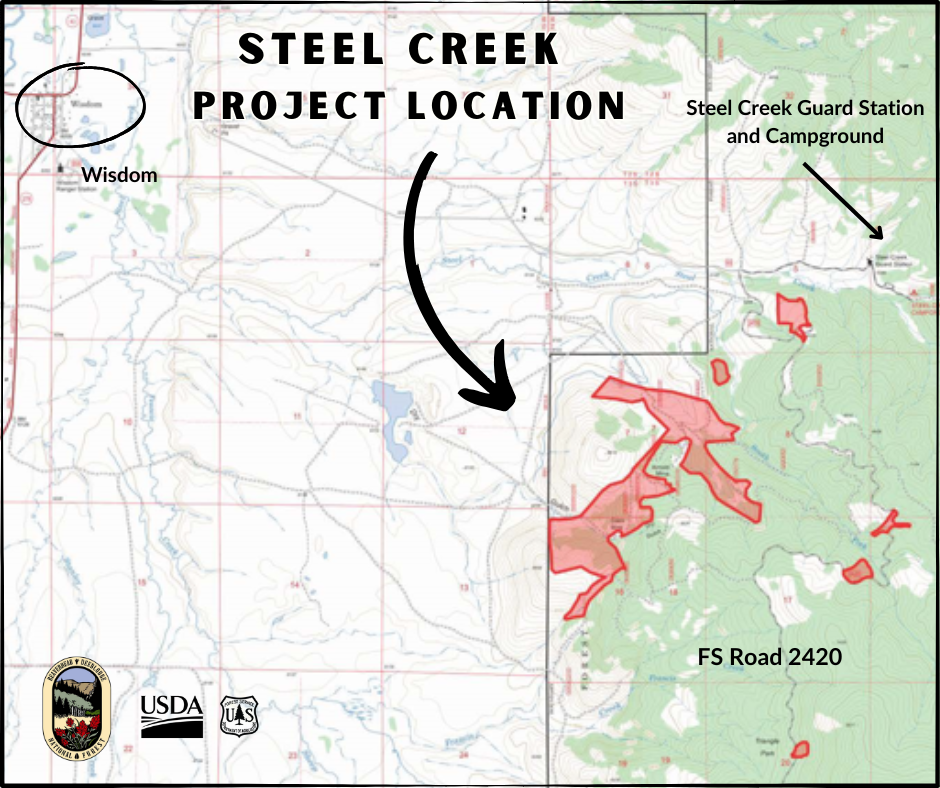
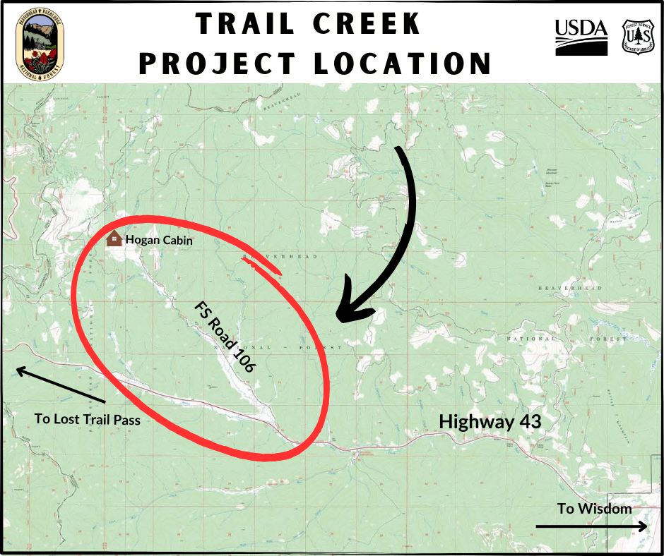
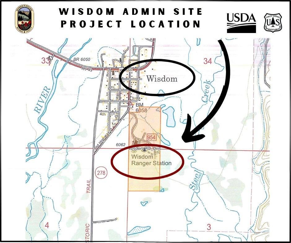
The Wisdom Ranger District has developed prescribed fire implementation plans for the following units:
Wisdom Admin Site - just southeast of Wisdom at FS site
Trail Creek - 17 miles west of Wisdom, along Hwy 43 on Trail Creek Road 106
Steel Creek - 2 miles east of Wisdom
Dillon Ranger District Rx Fire Operations Spring 2025 03 28 2025
Related Incident: Beaverhead-Deerlodge NF Prescribed Fire Operations
Publication Type: Announcement
The Dillon Ranger District has developed prescribed fire implementation plans for the following units:
French Creek - 4 miles northwest of Argenta
Middle Fork Little Sheep Creek - 10 miles southwest of Lima
Butte Ranger District Rx Fire Operations Spring 2025 03 28 2025
Related Incident: Beaverhead-Deerlodge NF Prescribed Fire Operations
Publication Type: Announcement
The Butte Ranger District has developed prescribed fire implementation plans for the following units:
Red Rocks - 1 mile west of the Bernice exit on I-15, between Butte and Boulder, MT.
Fleecer - 3 miles west of the Feely exit on I-15, south of Rocker, MT.
Big Ridge Fire Update March 28 03 28 2025
Related Incident: Big Ridge Fire
Publication Type: News
Highlights: Today at 6 a.m. the Southern Area Gold Complex Incident Management Team assumed management of the Big Ridge Fire under the leadership of Incident Commander Paul Varnedoe. The Gold Team expresses its appreciation to the Forest Type 3 Team, Rabun Couty Sheriff’s Office, cooperators, collaborators and the community for their support to the firefighters. Firelines on the north side of the fire continued to hold Thursday and there was growth to the south and east. A virtual public meeting will be held in Sky Valley Saturday with details to follow.
Fire Activity: Today firefighters will focus holding the north line from Rabun Bald to Wilson Knob to keep the fire from Sky Valley. Crews will continue constructing direct line from Wilson Knob to south to Walnut Fork. On the southeast side of the fire line is being constructed from Sara’s Creek to Hale Ridge Road, which will serve as the eastern primary control line. On the north, line is being constructed from Beegum Gap to Hale Ridge Road following Holcomb Creek. Firefighters are also scouting and constructing secondary control lines in case these primary control lines are compromised.
The U.S. Forest Service Law Enforcement and Investigations is seeking information regarding the circumstances around the cause of the Big Ridge Fire. If anyone was in the area on March 22, 2025, and observed suspicious activity please call the Georgia Forestry Commission Arson Hotline 1-800-428-7337.
Weather: A Red Flag Waring is in effect today for critical fire danger. Today’s forecast calls for 72 degrees and minimum relative humidity of 19%. Winds will be southwest with sustained speeds of 10 mph and gusts of 23 mph. Temperatures and wind will increase early Saturday ahead of a change to higher humidity and possible rainfall after dark on Saturday into Sunday morning.
Evacuations: None.
Closures: Visit https://inciweb.wildfire.gov/incident-closures/gachf-big-ridge-fire
More Information:
Facebook: https://www.facebook.com/ChattOconeeNF
Email: 2025.BigRidge@firenet.gov
Fire Information: 770-530-3950
Inciweb: https://inciweb.wildfire.gov/incident-information/gachf-big-ridge-fire
Daily Update Rattlesnake Branch Fire 20250328 03 28 2025
Related Incident: Rattlesnake Branch
Publication Type: News
Rattlesnake Branch Fire Daily Update. March 28, 2025
Location: Less than one mile southwest of Cruso, North Carolina
Start date: March 26, 2025
Estimated size: 629 acres
Containment: 5 percent
Personnel: 80
Firefighters from the USDA Forest Service, the North Carolina Forest Service and nearby counties continue to make progress to contain the Rattlesnake Branch Fire.
Initially igniting on private land in Haywood County, the fire has continued to spread into both state- and federally managed public lands, including the Shining Rock Designated Wilderness Area on the Pisgah National Forest. These areas include hardwood forests impacted by Hurricane Helene.
Firefighters have constructed dozer lines and handlines near State Highway 276 to protect structures and conducted burnout operations to remove fuel near homes.
Weather: Conditions this spring have increased fire danger in North Carolina. Above- average temperatures are expected today with a southwesterly breeze gusting to 25 mph. Saturday should remain dry with warm daytime highs reaching the upper 70s to lower 80s. Increased fire activity will increase smoke production and degrade air quality in the area. Asheville and surrounding areas will likely see air that is unhealthy for sensitive groups.
Closures and Restrictions: Shining Rock Wilderness Area is closed due to the spread of the Rattlesnake Branch Fire. This closure includes all National Forest System land between US-276 and NC-215 north of the Blue Ridge Parkway (between mile markers 405 and 420). Visitor and employee safety are the highest priorities for the Forest Service, so the public should stay out of this area while federal, state and local fire crews work to contain the blaze.
Following the statewide burn ban issued for North Carolina, the Forest Service issued a restriction on open burning National Forest land, including building, maintaining or using campfires, open stove fires and fire rings, to mitigate wildfire risks.
For wildfire updates, follow the National Forests in North Carolina on Facebook at www.facebook.com/nfsnc. Updates will be posted on our website at https://www.fs.usda.gov/alerts/nfsnc/alerts-notices.
Smoke Outlook - Western North Carolina - Upstate South Carolina
Settings - change map background and toggle additional layers
Filter - control incident types displayed on map.
Zoom to your location
Reset map zoom and position
Could not determine your location.
Show Legend
 Wildfire
 Prescribed Fire
 Burned Area
Response
Burned Area
Response Other
Other