
DNR Emergency Area Closure For Portions of Lake County
Related Incident:
Publication Type: Closures
EMERGENCY AREA OF CLOSURE BY THE DEPARTMENT OF NATURAL RESOURCES, DIRECTOR OF FORESTRY RESTRICTING OCCUPANCY AND USE OF PORTIONS OF LAKE COUNTY, MINNESOTA.
August 21, 2021
Pursuant to the provisions of Minnesota Statutes, 88.73 and 89.01, portions of Lake County, Minnesota, are under emergency closure due to hazards associated with the Greenwood fire.
This area of closure is established to protect the public's health and safety due to hazards posed by the Greenwood fire and includes all state, or state administered, lands, waters, trails, portages, canoe routes, and recreation sites that can be found within the perimeter of the closure. See map and closure order below.
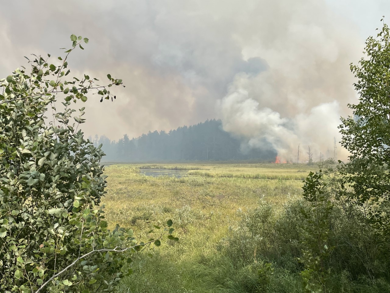
Greenwood Fire UpdateAugust 22 2021
Related Incident:
Publication Type: News
A PUBLIC MEETING will be held Monday, Aug. 23rd at 6:00 pm for the Greenwood Fire, Superior National Forest fires and the Boundary Waters Canoe Area Wilderness closure with presentations from the Forest Service, Sheriff, and the Incident Command Team. It will be held at the Wolf Ridge Environmental Learning Center and will be broadcast live on the Superior National Forest Facebook page.
Yesterday and Last Night: With light winds and cool temperatures the fire remained in the same footprint. Acreage reduced to 8,862 based on infrared mapping. Day and night crews made good progress on fireline construction on the southern edge, at the fire’s base. Operations scouted new areas to hold the fire to the west and north of Highway 2 after Friday’s 4-mile run. Engine crews continued structure-protection measures on homes within the Sand Lake and Highway 2 corridor, McDougal Lake and in the areas to the north where there was fire growth.
Today and Tonight: Additional crews, engines and equipment are arriving to assist in fire suppression and structure protection. Operations will continue assessing additional structures, and recreation sites threatened by fire growth.
WEATHER/FIRE BEHAVIOR: Temperatures are 20 degrees colder with patchy fog this morning, slowing fire activity. Fire growth is expected primarily along the northern edge in the surface ground fuels and the potential for spotting is reduced.
SAFETY & EVACUATIONS: Lake County Sheriff’s office evacuation orders are in effect for McDougal Lake, Sand Lake, the Highway 2 corridor, and north of Highway 1 in the vicinity of East and West Chub lakes, Jackpot, and Slate Lake. For information regarding evacuations contact Lake County Emergency Management at 773-844-6449. You can sign up for emergency text alerts and calls from Lake County here: https://www.co.lake.mn.us/emergency-management/. An interactive evacuation map for Lake County is at: https://tinyurl.com/2kxfwuw8. A Red Cross shelter is set up at the Finland Community Center for evacuees and their small pets. Call (425) 677-5776 for more information.
CLOSURES:
- The Greenwood Fire forest closure order will be expanded to protect public health and safety due to the growth of the fire. It extends across areas within the Kawishiwi, Laurentian, and Tofte Ranger Districts and a small portion of the Boundary Waters Canoe Area Wilderness. Yesterday, the forest decided to close the entire Boundary Waters Canoe Area Wilderness due to wildfire activity elsewhere in the BWCAW and to ensure safety of visitors. To see the Forest order and other alerts go to: https://www.fs.usda.gov/superior.
- A Temporary Flight Restriction for aircraft is in place over the fire area.
FIRE RESTRICTIONS: Fire restrictions are in place for the Superior National Forest and Minnesota Department of Natural Resources for areas within state jurisdiction Cook and Lake Counties and northern St. Louis County. Superior National Forest: Fire Restrictions Order and our Campfire Restrictions See our FAQ for more information. Minnesota Department of Natural Resources: MN DNR Wildland Fire Information.
SUMMARY: The Greenwood Fire was detected on August 15, 2021, around 3 pm on the Laurentian Ranger District. The fire is near Greenwood Lake and approximately 15 miles southwest of Isabella. The objective of fire management is full suppression using ground resources, heavy equipment, and aircraft. The fire is threatening cabins, homes, and recreational sites. The fire was caused by lightning.
Greenwood Fire Update August 21 2021
Related Incident:
Publication Type: News
WEATHER/FIRE BEHAVIOR: Last night, the fire received minimal precipitation. We anticipate that we will continue to experience winds capable of producing active fire behavior.
SUMMARY: The Greenwood Fire was detected on August 15, 2021, around 3 pm on the Laurentian Ranger District. The fire is near Greenwood Lake and approximately 15 miles southwest of Isabella. The objective of fire management is full suppression using ground resources, heavy equipment, and aircraft. The fire is threatening cabins, homes, and recreational sites. The fire was caused by a lightning strike.
SAFETY & EVACUATIONS: Lake County Sheriff’s office evacuation orders are in effect for McDougal Lake, Sand Lake, the Highway 2 corridor, and north of Highway 1 in the vicinity of East and West Chub lakes, Jackpot, and Slate Lake. For information regarding evacuations contact Lake County Emergency Management at 773-844-6449. You can sign up for emergency text alerts and calls from Lake County here: https://www.co.lake.mn.us/emergency-management/. If you or your small pets need shelter, there is a Red Cross shelter at the Finland Community Center for those who have been evacuated (425-677-5776).
CLOSURES:
AIR QUALITY: The Minnesota Pollution Control Agency (MPCA) has issued an air quality alert effective until 3 p.m. on Monday, Aug. 23, for Lake and Cook Counties. The affected area includes Isabella, Silver Bay, Grand Marais, and the tribal nation of Grand Portage. For other areas go to: Air Quality Index webpage.
FIRE RESTRICTIONS: Fire restrictions are in place for the Superior National Forest and Minnesota Department of Natural Resources for areas within state jurisdiction Cook and Lake Counties and northern St. Louis County. Superior National Forest: Fire Restrictions Order and our Campfire Restrictions See our FAQ for more information. Minnesota Department of Natural Resources: MN DNR Wildland Fire Information.
Greenwood Fire August 20 Evening Post
Related Incident:
Publication Type: News
Greenwood Fire AnnouncementEvacuations west of Hwy 2820
Related Incident:
Publication Type: Announcement
Greenwood Fire Announcement for Aug 20 at 2:00 pm. The Greenwood Fire jumped over to the west side of Highway 2, just north of Stony Lake. Fire crews and aircraft are responding. The Lake County Sheriff's Department is onsite and evacuating residents. The fire crossed over a point designated as a Management Action Point, triggering evacuations in the Sand Lake and Stony Lake areas. Lake County Emergency Management: 773-844-6449Greenwood Fire Public Information Line: 218-499-9441Greenwood Fire Phone Line for Media Inquiries: 614-205-9333The photos are from the road closure on Highway 1 and a photo of the extreme fire behavior.
Greenwood Fire Update August 20 2021
Related Incident:
Publication Type: News
Yesterday The fire grew to 4,734 acres with no containment. Day and night shift fire crews continued structure protection on the west side within the Highway 2 corridor, McDougal and Stony River areas. There are no reports of structures lost. Hand crews, equipment and engine crews continued fireline construction and laying hoseline on the southern edge at the fire’s base. New crews and equipment arrived to assist in fire suppression and in scouting locations for constructing fireline. A public meeting was held in Finland to discuss the fire activity, suppression response and what is expected over the next few days. The meeting and Q&A’s are posted on the Superior NF Facebook Page.
Today and Tonight Hand crews, engines, equipment, and aircraft will continue fire suppression during this critical fire weather day. Structure protection, including brush clearing, creating defensible space, and hose laying will continue. Personnel have increased to 253 with 3 hand crews, 38 engines, 2 dozers, 3 tenders, and 3 aircraft assigned to the incident in addition to engines, equipment and aircraft from cooperators and partners.
WEATHER/FIRE BEHAVOIR: We are expecting critical fire weather today with high winds ahead of a thunderstorm. Hot and dry conditions will contribute to the potential for very active or extreme fire behavior this afternoon.
SUMMARY: The Greenwood Fire was detected on August 15, 2021, around 3 pm on the Laurentian Ranger District. The fire is near Greenwood Lake and approximately 15 miles southwest of Isabella, Crews are responding with full suppression using ground resources and aircraft. The fire is threatening cabins, homes, and recreational sites. The cause of the fire is lightning.
SAFETY & EVACUATIONS: Lake County Sheriff’s office evacuation orders are in effect for McDougal Lake, Sand Lake, the Highway 2 corridor, and just north of Highway 1. For information regarding evacuations contact Lake County Emergency Management at 773-844-6449. You can sign up for emergency text alerts and calls from Lake County here: https://www.co.lake.mn.us/emergency-management/. There is a Red Cross shelter at the Finland Community Center for those who have been evacuated. If you need shelter, you can contact the shelter manager at 425-677-5776. Lake County Emergency Management set up a pet shelter front of the community center. If your pets need shelter, you can contact them at the emergency management number above.
CLOSURES:
- Hwy 2 is closed from Forest Hwy 11 to Hwy 1. Hwy 1 is closed from New Tomahawk Rd to Lankinen Rd.
- A Forest Service closure order is in place to protect public health and safety due to the Greenwood Fire. It extends across areas within the Kawishiwi, Laurentian, and Tofte Ranger Districts and a small portion of the Boundary Waters Canoe Area Wilderness. To see the full Forest order and other alerts go to: https://www.fs.usda.gov/superior.
- A Temporary Flight Restriction for aircraft is in effect over the fire area.
FIRE INFORMATION: For Greenwood Fire information, visit Inciweb at: https://inciweb.nwcg.gov/incident/7805/ or call 218-499-9441. For all other fires on the Superior National Forest, please call 218-214-7844.
AIR QUALITY: The Minnesota Pollution Control Agency has issued an air quality alert effective until 3 p.m. on Friday, August 20, for the inland portion of Minnesota’s Lake County. For other areas go to: Air Quality Index webpage.
FIRE RESTRICTIONS: Fire restrictions are in place for the Superior National Forest and Minnesota Department of Natural Resources for areas within state jurisdiction Cook and Lake Counties and northern St. Louis County.
Superior National Forest: Fire Restrictions Order and our Campfire RestrictionsSee our FAQ for more information.
Minnesota Department of Natural Resources: MN DNR Wildland Fire Information.
Greenwood Fire UpdateAugust 19 2021
Related Incident:
Publication Type: News
GREENWOOD FIRE UPDATE – AUGUST 19, 2021
PUBLIC MEETING: A public meeting will be held tonight at the Wolf Ridge Environmental Learning Center auditorium at 6282 Cranberry, Rd, Finland, MN 55603 at 6:00 pm. The Forest Service will discuss the Forest closure, the Sheriff will discuss evacuations and the Incident Commander will provide a fire update. This meeting will be presented in person as well as on the Superior N.F. Facebook Page.
Yesterday the fire grew an additional 1,000 acres on the west side, south of Stone Lake. Southeast winds pushed a portion of the fire west then north. Aircraft, heavy equipment, and structure protection crews increased suppression efforts to protect structures and hold the fire east of Highway Two. Hand crews continued to build fireline on the south end of the fire to create an anchor at its base. Structure protection continued in the McDougal and Stony River areas.
Today additional hand crews, engines, and equipment will assist in fire suppression along the east side of the Highway Two corridor. Aircraft will continue dropping water as well as retardant to slow fire spread to the west and north. Hand crews and equipment will continue to secure line along the southern portion of the fire. Additional crews arrived today to scout locations to access the eastern portion of the fire. Structure protection crews will assess new structures threatened by the fire and continue implementing structure protection measures within the McDougal and Stony Run areas. Crews will assess locations for fuel breaks along Highway 1 on the northern side of the fire. There are 145 fire personnel with 25 engines, 2 dozers, 3 tenders, and 3 aircraft assigned to the incident in addition to engines and equipment from cooperators and partners.
SUMMARY: The Greenwood Fire was detected on August 15, 2021, around 3 pm on the Laurentian Ranger District. The fire is near Greenwood Lake and approximately 15 miles southwest of Isabella, MN and estimated to be around 4,000 acres. Crews are responding with full suppression using ground resources and aircraft. The fire is threatening cabins, homes, and recreational sites. The cause of the fire is lightning.
WEATHER/FIRE BEHAVOIR: Warm weather continues through Friday. Today’s temperatures are expected to reach 90 degrees. Humidity is expected to be 35% with winds out of the south. Active fire behavior is expected again today.
SAFETY & EVACUATIONS: Lake County Sheriff’s office evacuation orders are in effect for McDougal Lake, Sand Lake, the Highway 2 corridor, and just north of Highway 1. For information regarding evacuations contact Lake County Emergency Management at 773-844-6449. You can sign up for emergency text alerts and calls from Lake County here: https://www.co.lake.mn.us/emergency-management/. There is a Red Cross shelter at the Finland Community Center for those who have been evacuated. If you need shelter, you can contact the shelter manager at 425-677-5776.
CLOSURES:
- Hwy 2 is closed from Forest Hwy 11 to Hwy 1. Hwy 1 is closed from New Tomahawk Rd to Lankinen Rd.
- A Forest Service closure order is in place to protect public health and safety due to the Greenwood Fire. It extends across areas within the Kawishiwi, Laurentian, and Tofte Ranger Districts and a small portion of the Boundary Waters Canoe Area Wilderness. To see the full Forest order and other alerts go to: https://www.fs.usda.gov/superior
FIRE INFORMATION: For Greenwood Fire information, visit Inciweb at: https://inciweb.nwcg.gov/incident/7805/ or call 218-499-9441. For all other fires on the Superior National Forest, please call 218-214-7844.
AIR QUALITY: The Minnesota Pollution Control Agency has issued an air quality alert effective until 3 p.m. on Friday, August 20, for the inland portion of Minnesota’s Lake County. For other areas go to: Air Quality Index webpage.
FIRE RESTRICTIONS: Fire restrictions are in place for the Superior National Forest and Minnesota Department of Natural Resources for areas within state jurisdiction Cook and Lake Counties and northern St. Louis County.
Superior National Forest: Fire Restrictions Order and our Campfire RestrictionsSee our FAQ for more information.
Minnesota Department of Natural Resources: MN DNR Wildland Fire InformationGREENWOOD FIRE UPDATE AUGUST 18 2021
Related Incident:
Publication Type: News
SUMMARY: The Greenwood Fire was detected on August 15, 2021, around 3 pm on the Laurentian Ranger District. The fire is near Greenwood Lake and approximately 15 miles southwest of Isabella, MN and estimated to be around 3,200 acres. Crews are responding with full suppression using ground resources and aircraft. The fire is threatening cabins, homes, and recreational sites. The cause of the fire is currently under investigation.
The Eastern Area Type 2 Incident Management Gold Team, with Incident Commander Brian Pisarek, assumed command of the fire this morning at 6:00 am. There are currently 42 personnel, two helicopters, one fixed wing aircraft, eight engines, two dozers, and two tracked vehicles assigned to the fire with additional firefighting personnel on order.
Today, crews will begin building fireline on the south end of the fire near Greenwood lake. Aircraft will continue to limit fire spread to the north and monitor the fire growth along the western side. Fire personnel will look for suppression opportunities on both the eastern and western sides of the fire. Additional fire suppression engines and crews will arrive today to expand suppression efforts today and tonight. A public meeting will be held Thursday night at 6:00 pm at the Wolf Ridge Environmental Center in Finland. It will be broadcast on FaceBook as well.
WEATHER: Warmer weather is expected to continue the next three days with today’s temperature expected to reach 90 degrees. Humidity is expected to rise into the high 30 percent range and winds will continue out of the south. Active fire behavior is expected today.
SAFETY & EVACUATIONS: Lake County Sheriff’s office evacuation orders are in effect for McDougal Lake, Sand Lake, the Highway 2 corridor, and just north of Highway 1. For information regarding evacuations contact Lake County Emergency Management at 773-844-6449. You can sign up for emergency text alerts and calls from Lake County here: https://www.co.lake.mn.us/emergency-management/. A Red Cross shelter is now up and running at the Finland Community Center for those who have been evacuated. If you need shelter, you can contact the shelter manager at 425-677-5776.
CLOSURES: Highway 2 is closed from Forest Hwy 11 to Hwy 1. Highway 1 is closed from New Tomahawk Rd to Lankinen Rd.
FOREST CLOSURES: A Forest Service closure order is in place to protect public health and safety due to the Greenwood Fire. It extends across areas within the Kawishiwi, Laurentian and Tofte Ranger Districts and a small portion of the Boundary Waters Canoe Area Wilderness. To see the full Forest order and other alerts go to: https://www.fs.usda.gov/superior
FIRE INFORMATION: For Greenwood Fire information, visit Inciweb at: https://inciweb.nwcg.gov/incident/7805/ or call 218-499-9441. For all other fires on the Superior National Forest, please call 218-214-7844.
AIR QUALITY: The Minnesota Pollution Control Agency has issued an air quality alert effective until 3 p.m. on Friday, August 20, for the inland portion of Minnesota’s Lake County. The affected area includes Stony River Township and Fall Lake Township. For air quality information, visit MPCA’s Air Quality Index webpage.
FIRE RESTRICTIONS: Fire restrictions are in place for the Superior National Forest and Minnesota Department of Natural Resources for areas within state jurisdiction Cook and Lake Counties and northern St. Louis County. Campfire and recreational fires are banned in Cook and Lake counties on all public and private lands. The Grand Portage Band of Lake Superior Chippewa has also restricted burning on its lands.
The Forest is not allowing campfires or charcoal fires within the Forest boundary on National Forest lands, including the BWCAW. Propane and gas powered stoves with on/off valves are allowed. Superior National Forest: Fire Restrictions Order and our Campfire RestrictionsSee our FAQ for more information.
Minnesota Department of Natural Resources: MN DNR Wildland Fire Information
Greenwood Fire McDougal Lake Area Closure
Related Incident:
Publication Type: Closures
The Greenwood Fire was detected on 8/15/2021 around 3 pm on the Laurentian Ranger District. The fire is near Greenwood Lake, approx. 15 miles southwest of Isabella, MN. Effective August 17, 2021, a Forest Service closure is in place across the Forest and into a small portion of the Boundary Waters Canoe Area Wilderness across the Kawishiwi, Laurentian and Tofte Ranger Districts. The Forest is implementing a closure in the Forest and into a small portion of the Boundary Waters Canoe Area Wilderness due to the Greenwood Fire. This includes all lands, waters, trails, portages, canoe routes, Wilderness entry points, and recreation sites as shown on the map, exhibit A, in the closure order. Private property owners can access private property. State Highway 1 and County Highway 2 are excluded from the order.
Greenwood Fire Fact Sheet 8172021
Related Incident:
Publication Type: News
FIRE INFORMATION: For Greenwood Fire information, visit Inciweb.nwcg.gov or call 218-499-9441. For information on closures, visit the Superior National Forest alerts and notices page. For all other fires on the Superior National Forest, please call 218-214-7844.
SUMMARY: The Greenwood Fire was detected on August 15, 2021 around 3 pm on the Laurentian Ranger District. The fire is near Greenwood Lake and approximately 15 miles southwest of Isabella, MN and estimated to be around 2,000 acres. Yesterday, fire behavior was observed to be extreme with torching and long-range spotting. Aircraft is being used to limit the fire spread to the north. Full suppression tactics are being used to reduce fire spread. The fire is located outside of the wilderness area and threatens cabins, homes, and recreational sites. Aircraft flew the area this morning to get a better estimate on the footprint. The cause of the fire is currently under investigation. Fire crews are suppressing the fire on the ground and from the air.
The Forest Service, Lake County and the Minnesota Department of Natural Resources are currently in unified command. A Type 2 Team was briefed in yesterday evening and will assume full command of the fire on Wednesday morning. There are currently two helicopters, one fixed wing aircraft, eight engines, two dozers, and two tracked vehicles assigned to the fire.
WEATHER: Warmer weather and gusty winds out of the south will continue through the majority of the week. Humidity levels are increasing from the weekend and will be around 30-35%. Tomorrow, hazy skies from the west will move in once again and should knock a few degrees off our high temperatures. Temperatures will be in the high 80s to low 90s.
SAFETY & EVACUATIONS: Evacuations are in effect for McDougal Lake, Sand Lake, the Highway 2 corridor, and just north of Highway 1. The Lake County Sheriff visited approximately 75 dwellings in the vicinity and either notified residents of the evacuation area or left a notice on the door if no one was home. If you have been evacuated and need resources, please call Lake County Emergency Management at 773-844-6449. You can sign up for emergency text alerts and calls from Lake County here: https://www.co.lake.mn.us/emergency-management/.
CLOSURES: Highway 2 is closed from Forest Hwy 11 to Hwy 1. Highway 1 is closed from New Tomahawk Rd to Lankinen Rd.
Effective today, a Forest Service closure is in place across the forest and into a small portion of the Wilderness across the Kawishiwi, Laurentian and Tofte Ranger Districts. The forest is implementing a closure in the forest and into a small portion of the Boundary Waters Canoe Area Wilderness due to the Greenwood Fire. This includes all lands, waters, trails, portages, canoe routes, Wilderness entry points, and recreation sites as shown on the map, exhibit A, in the closure order. Private property owners can access private property. State Highway 1 and 2 are excluded from the order.
AIR QUALITY: The MPCA has issued an Air Quality Alert for inland Lake County due to wildfire smoke from the Greenwood Fire effective through 3 p.m. today. The affected area will be limited to areas near and directly downwind of the fire to the north and northeast. For more information on current air quality conditions in your area and to sign up for daily air quality forecasts and alert notifications by email, text message, phone, visit MPCA’s Air Quality Index webpage.
FIRE RESTRICTIONS: Due to continued long-term drought conditions and limited fire-fighting resources, the Superior National Forest is not allowing campfires or charcoal fires within the Forest boundary on National Forest lands, including the BWCAW. Propane devices with an on/off switch are permitted, including lanterns, stoves, and firepits. Campfires or charcoal fires are NOT allowed at any BWCAW campsites, backcountry campsites, or rustic campgrounds, even in designated fire rings or grates or grills. Please see Fire Restrictions Order and our Campfire Restrictions. See our FAQ for more information.
The MN DNR activated additional burning restrictions for areas within state jurisdiction in Cook and Lake counties, and northern St. Louis County. Under the additional restrictions, all campfires and recreational fires are banned and the use of welding devices and other torches is prohibited when in proximity to combustible vegetation (unless special permission is granted). The Grand Portage Band of Lake Superior Chippewa has also restricted burning on its lands.
Under these additional restrictions, the campfire and recreational fire ban in Cook and Lake counties now includes all public and private land. In the backcountry, and at campsites, only gas or propane camp stoves are allowed. Gas and charcoal grills are allowed at occupied homes, cabins, and resorts. Charcoal and gas fires must be in devices designed for grilling. Please see MN DNR Wildland Fire Information for details.