
Windy Fire Update October 17 2021
Related Incident: Windy Fire
Publication Type: News
StartDate: 9/9/21
Cause: Lightning
Size: 97,554 acres
Percent Containment: 88
Helicopters: 6
Engines: 14
Crews: 5
Dozers: 5
Total Personnel: 425
CURRENT CONDITIONS: The Windy Fire was mostly quiet Saturday despite very low humidity and several days of above-average temperatures. Because fire activity was low to moderate most of the day, crews had an opportunity to continue repairing and reinforcing containment line.
The only sections of fireline that remain uncontained are a four-mile stretch between Devils Den and Cold Springs on the west side, a two-mile section between Tobias Creek and Ant Canyon on the southeast side, and a one-mile gap near Coy Creek at the northern edge.
A dry and breezy cold front will move quickly over the fire area today. Stronger winds will last through Monday, and temperatures will steadily drop to seasonal norms.
SEQUOIA NATIONAL FOREST CLOSURES REMAIN: The Windy Fire Area, Trails, and Roads Closure established by the Sequoia National Forest, Giant Sequoia National Monument, and Western Divide Ranger District remains in effect. Only authorized Forest and fire personnel are allowed inside the closed areas. Roadblocks remain at Western Divide Highway (M107) near Ponderosa, M99 at Lloyd Meadow Road, and Parker Pass (M50) at Parker Meadow above California Hot Springs. Details are available online at the following sites:
- Windy Fire Forest Order: https://inciweb.nwcg.gov/incident/article/7841/67270/
- Windy Fire Area, Trails, and Roads Closure map: https://inciweb.nwcg.gov/photos/CASQF/2021-09-12-1443-Windy/related_files/pict20210909-165257-0.jpeg
- Fire updates and Forest Orders: https://www.fs.usda.gov/sequoia.
###
Windy Fire Update October 16 2021
Related Incident: Windy Fire
Publication Type: News
Start Date: 9/9/21
Cause: Lightning
Size: 97,554 acres
Percent Containment: 88
Helicopters: 6
Engines: 17
Crews: 6
Dozers: 5
Total Personnel: 484
CURRENT CONDITIONS: Over the weekend and early next week, Windy Fire incident managers are shifting firefighters from more secure portions of the containment line to sections that require reinforcement and repair. They also are assessing what other work must be done to leave the fire in a condition that local resources can manage.
Many firefighters are going home to rest, while others are being reassigned to other fires. Those remaining on the Windy Fire will continue to patrol the fireline, removing fire-weakened and fallen trees and extinguishing pockets of fire. Residents traveling the same roads should watch for fire personnel and equipment.
WEATHER CONDITIONS: Temperatures will be 10 to 15 degrees above normal today, and humidity could drop into the single digits in the afternoon.
SEQUOIA NATIONAL FOREST CLOSURES REMAIN: The Windy Fire Area, Trails, and Roads Closure established by the Sequoia National Forest, Giant Sequoia National Monument, and Western Divide Ranger District remains in effect. Only authorized Forest and fire personnel are allowed inside the closed areas. Roadblocks remain at Western Divide Highway (M107) near Ponderosa, M99 at Lloyd Meadow Road, and Parker Pass (M50) at Parker Meadow above California Hot Springs. Details are available online at the following sites:
Windy Fire Forest Order: https://inciweb.nwcg.gov/incident/article/7841/67270/
Windy Fire Area, Trails, and Roads Closure map: https://inciweb.nwcg.gov/photos/CASQF/2021-09-12-1443-Windy/related_files/pict20210909-165257-0.jpeg
- Fire updates and Forest Orders: https://www.fs.usda.gov/sequoia.
###
Windy Fire Update October 15 2021
Related Incident: Windy Fire
Publication Type: News
Start Date: 9/9
Cause: Lightning
Size: 97,554 acres
Percent Containment: 88
Helicopter: 7
Engines: 20
Crews: 8
Dozers: 6
Total Personnel: 559
At Thursday’s day-shift briefing, an elder from the Tule River Tribe blessed the fire personnel who have worked to suppress and contain the Windy Fire since its discovery on September 9. Before beginning his song, Joey Garfield thanked firefighters and support teams for protecting “the trees and the people who were here before them.” The fire began with a lightning strike on the Tule River Reservation, only a few months after the Nettle Fire began on tribal lands.
CURRENT CONDITIONS: Wednesday was the final night shift on the Windy Fire. Meanwhile, day crews continue removing fire-weakened or fallen trees and other fuels along firelines and suppressing pockets of heat near the line. Open sections of the Windy Fire containment line continue to be monitored by firefighters on the ground and infrared flights. These sections are in steep, remote terrain, where firefighters can’t safely get close to the fire’s edge to dig containment lines. This ground-and-air strategy allows firefighters to respond quickly if the fire threatens to spread.
While crews are making significant progress repairing fire suppression impacts, the Burned Area Emergency Response (BAER) Team continues to evaluate the burned area. The BAER team has reached out to local, state, and federal organizations to coordinate and share information about the fire. At the end of their assessment, they will propose emergency response actions to protect people, land, and critical natural and cultural heritage resources.
Drivers using open access roads near the fire boundary should be mindful of fire personnel and equipment.
SEQUOIA NATIONAL FOREST CLOSURES REMAIN: The Windy Fire Area, Trails, and Roads Closure established by the Sequoia National Forest, Giant Sequoia National Monument, and Western Divide Ranger District remains in effect. Only authorized Forest and fire personnel are allowed inside the closed areas. Roadblocks remain at Western Divide Highway (M107) near Ponderosa, M99 at Lloyd Meadow Road, and Parker Pass (M50) at Parker Meadow above California Hot Springs. Details are available online at the following sites:
• Windy Fire Forest Order: https://inciweb.nwcg.gov/incident/article/7841/67270/
• Windy Fire Area, Trails, and Roads Closure map: https://inciweb.nwcg.gov/photos/CASQF/2021-09-12-1443-Windy/related_files/pict20210909-165257-0.jpeg
• Fire updates and Forest Orders: https://www.fs.usda.gov/sequoia.
SMOKE REPORTS: Smoke reports will no longer be issued for the Windy Fire.
###
Windy Fire Update October 14 2021
Related Incident: Windy Fire
Publication Type: News
Start Date: 9/9
Cause: Lightning
Size: 97,554 acres
Percent Containment: 88
Helicopters: 8
Engines: 22
Crews: 10
Dozers: 7
Total Personnel: 657
CURRENT CONDITIONS: Firefighters are removing hazard trees and suppressing fire near containment lines and in sequoia groves. Hazards in the fire area include fire-weakened trees, smoldering stump holes, and rocks or debris that could fall from steep slopes onto trails and into roadways. These hazards present dangers to the public long after a fire is considered controlled. Drivers should be aware of fire personnel and equipment on the ground and on access roads.
Firefighters are also using frequent infrared flights to monitor open sections of the Windy Fire containment line. These areas are in steep, remote terrain, where it’s unsafe for firefighters to use direct suppression tactics. This strategy allows crews to respond quickly if the fire begins to spread, and it could continue until significant precipitation falls over the forest.
EVACUATION ORDERS AND WARNINGS LIFTED: The Tulare County Sheriff’s Office lifted all Evacuation Orders and Warnings for the Windy Fire effective Wednesday. That action affected all structures, residences, and businesses in the communities of Mountain Aire, Rogers Camp, Upper and Lower Peppermint, Camp Whitsett, R Ranch, Johnsondale, Sugarloaf, Sugarloaf Sawmill, Sugarloaf Mountain Park, Ponderosa, Idlewild, Balance Rock, Poso Park, Quaking Aspen, Camp Nelson, Pierpoint, Coy Flat, Cedar Slope, Alpine Village, Sequoia Crest, McNallys, California Hot Springs, Posey, Panoramic Heights, and Gold Ledge.
SEQUOIA NATIONAL FOREST CLOSURES REMAIN: The Windy Fire Area, Trails, and Roads Closure established by the Sequoia National Forest, Giant Sequoia National Monument, and Western Divide Ranger District remains in effect. Only authorized Forest and fire personnel are allowed inside the closed areas. Roadblocks remain at Western Divide Highway (M107) near Ponderosa, M99 at Lloyd Meadow Road, and Parker Pass (M50) at Parker Meadow above California Hot Springs.
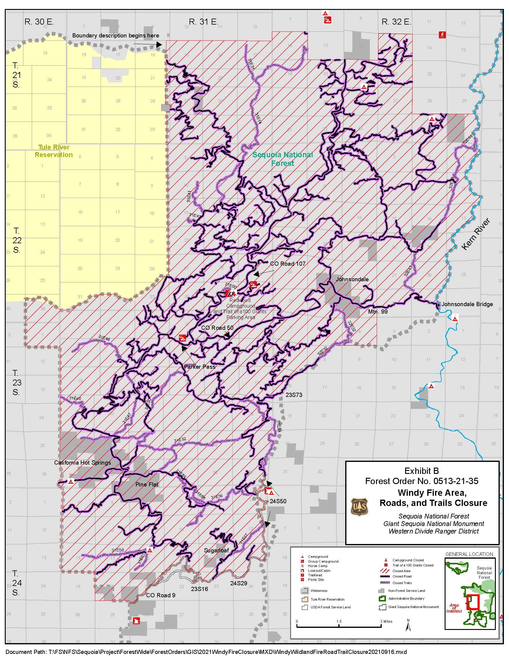
Under Forest Order No. 0513-21-35, the west side of the Sequoia National Forest is closed to recreation on M50 where it reaches the Forest boundary near California Hot Springs. The southern edge of the closure boundary ties in with the northern perimeter of the French Fire Closure Area near White River. The northern edge of the closure boundary ties in with the Castle Fire Closure Area near Ponderosa. M99, coming from Kernville, is closed near Johnsondale Bridge. A full description of the Windy Fire Forest Order is available at https://inciweb.nwcg.gov/incident/article/7841/67270/. For the current Windy Fire Area, Trails, and Roads Closure map, visit https://inciweb.nwcg.gov/photos/CASQF/2021-09-12-1443-Windy/related_files/pict20210909-165257-0.jpeg.
Fire updates and Forest Orders can be monitored on Inciweb and the Sequoia National Forest website at https://www.fs.usda.gov/sequoia.
SEQUOIA STATUS UPDATE: A preliminary evaluation of individual groves, historic structures, and Forest Service infrastructure that were lost in the Windy Fire is posted on the Sequoia National Forest and Giant Sequoia National Monument website at https://www.fs.usda.gov/news/sequoia/news-events.
TULARE COUNTY RESIDENT INFORMATION: Residents requesting information on the status of their property can call the Tulare County Information Hotline at (559) 802-9790. Affected property owners should complete the September Lightning Fire Information Form online at: https://bit.ly/3ETdZjI. Residents can sign up to receive county emergency notifications by registering at AlertTC.com.
###
Tulare County Sheriffs Office Lifts Evacuations
Related Incident: Windy Fire
Publication Type: Announcement
(The following information was taken directly from either Tulare County Sheriff's Office website or Facebook page.)
The Tulare County Sheriff’s Office lifted all Evacuation Orders and Warnings for the Windy Fire effective noon Wednesday. That action affected all structures, residences, and businesses in the communities of Mountain Aire, Rogers Camp, Upper and Lower Peppermint, Camp Whitsett, R Ranch, Johnsondale, Sugarloaf, Sugarloaf Sawmill, Sugarloaf Mountain Park, Ponderosa, Idlewild, Balance Rock, Poso Park, Quaking Aspen, Camp Nelson, Pierpoint, Coy Flat, Cedar Slope, Alpine Village, Sequoia Crest, McNallys, California Hot Springs, Posey, Panoramic Heights, and Gold Ledge.
Sheriff Boudreaux and the United States Forest Service want to remind everyone the National Forest remains closed. Fire personnel and heavy equipment are still traveling throughout the area. Please be mindful of the personnel on the ground and equipment in the area.Roadblocks will remain at M107 at Aspen, M99 at Lloyd Meadow, and M50 at Parker Meadow.
Windy Fire Update October 13 2021
Related Incident: Windy Fire
Publication Type: News
Start Date: 9/9
Cause: Lightning
Size: 97,554
Percent Containment: 88
Helicopters: 9
Engines: 36
Crews: 13
Dozers: 7
Total Personnel: 798
CURRENT CONDITIONS: The Tulare County Sheriff’s Office will remove all Evacuation Orders and Warnings for the Windy Fire effective at noon today (Oct. 13). Sheriff Boudreaux will remove all Evacuation Orders and Warnings associated with the Windy Fire for the communities of Mountain Aire, Rogers Camp, Upper and Lower Peppermint, Camp Whitsett, R Ranch, Johnsondale, Sugarloaf, Sugarloaf Sawmill, Sugarloaf Mountain Park, Ponderosa, Idlewild, Balance Rock, Poso Park, Quaking Aspen, Camp Nelson, Pierpoint, Coy Flat, Cedar Slope, Alpine Village, Sequoia Crest, McNallys, California Hot Springs, Posey, Panoramic Heights, and Gold Ledge. These areas will include all structures, residences, and businesses.
See the Windy Evacuation Area Map at https://tularecounty.ca.gov/emergencies/.
The Windy Fire Area, Trails, and Roads Closure established by the Sequoia National Forest, Giant Sequoia National Monument, and Western Divide Ranger District remains in effect. Many hazards exist in the fire area: fire weakened trees, smoldering stump holes, and rocks or debris that could fall from steep slopes onto trails and into roadways. These pose an immediate safety concern to the public long after a fire reaches containment. Only authorized Forest and fire personnel are allowed inside the closed areas. Roadblocks remain at Western Divide Highway (M107) near Ponderosa, M99 at Lloyd Meadow Road, and Parker Pass (M50) at Parker Meadow above California Hot Springs.
Under the current Forest Closure Order, the west side of the Sequoia National Forest is closed to recreationon M50 where it reaches the Forest boundary near California Hot Springs. The southern edge ties in with the northern perimeter of the French Fire closed area near White River. The northern edge ties in with the Castle Fire closed area near Ponderosa. M99, coming from Kernville, is closed near Johnsondale Bridge. See a full description of the Forest Order at https://inciweb.nwcg.gov/incident/article/7841/67270/. For the current Windy Fire Area, Trails, and Roads Closure map, visit https://inciweb.nwcg.gov/photos/CASQF/2021-09-12-1443-Windy/related_files/pict20210909-165257-0.jpeg
Please continue to monitor fire updates, Inciweb, and the Sequoia National Forest website at https://www.fs.usda.gov/sequoia for current status regarding Forest Closures.
Drivers should be mindful of fire personnel on the ground and fire equipment in the area. Crews continue to remove hazard trees and suppress fire near containment lines and in sequoia groves.
SEQUOIA STATUS UPDATE: The Sequoia National Forest and Giant Sequoia National Monument announced Tuesday that the Windy Fire burned into 11 giant sequoia groves: eight within the Forest, two on the Tule River Indian Reservation, and one shared across agency boundaries. All but four mature giant sequoias in the Starvation Creek Grove burned in a high-severity fire; recent wildfires and fuels reduction efforts reduced fire severity in three other groves. Four other groves will be evaluated once fire hazards decrease. For details about individual groves, historic structures, and Forest Service infrastructure that were lost, visit https://www.fs.usda.gov/news/sequoia/news-events.
WEATHER CONDITIONS: A warming and drying trend is forecast to last until Saturday. Relative humidity could drop to single digits by Saturday.
TULARE COUNTY RESIDENT INFORMATION: Residents requesting information on the status of their property can call the Tulare County Information Hotline at (559) 802-9790. Affected property owners should complete the September Lightning Fire Information Form online at: https://bit.ly/3ETdZjI. Residents can sign up to receive county emergency notifications by registering at AlertTC.com.
###
Windy Fire Update October 12 2021
Related Incident: Windy Fire
Publication Type: News
Start Date: 9/9
Cause: Lightning
Size: 97,554
Percent Containment: 88
Helicopters: 12
Engines: 39
Crews: 26
Dozers: 7
Total Personnel: 904
CURRENT CONDITIONS: Fire crews spent Monday patrolling and monitoring the Windy Fire containment lines to ensure they would hold against strong winds forecast for late morning to early evening. Predicted gusts exceeding 45 miles per hour did not occur near the fire area. Wind-driven dust created significant haze across the fire and in mountain foothills; this contributed to lower wind speeds on the ground in the fire area. Heavier fuels remaining in timbered stands and smoldering vegetation left from past fires continued burning at low intensity.
On the northern flank, firefighters will continue removing hazard trees and extinguishing isolated areas of heat. Similar work will be done on the southern flank in preparation for lifting evacuation orders in the Sugarloaf communities. On the eastern perimeter, firefighters aim to prevent fire growth into the Kern River Valley. On the western side, resource advisors will accompany crews that are cleaning up and reinforcing perimeter lines. In the sequoia groves, firefighters will continue efforts to prevent further fire damage.
WEATHER CONDITIONS: Dry and cool conditions prevailed overnight Monday. Dry and warming temperatures are expected to lower humidities for the remainder of the week as the area transitions from today’s northwest wind.
TULARE COUNTY RESIDENT INFORMATION: Residents requesting information on the status of their property can call the Tulare County Information Hotline at (559) 802-9790. Affected property owners should complete the September Lightning Fire Information Form online at: https://bit.ly/3ETdZjI. Residents can sign up to receive county emergency notifications by registering at AlertTC.com.
EVACUATION ORDERS AND WARNINGS: Because evacuation orders and warnings change often as fire containment grows, evacuees should refer to the Windy Fire Evacuation Warning Map at https://tularecounty.ca.gov/emergencies/ or call 211 for the latest information. Evacuation updates can be found on Inciweb at https://inciweb.nwcg.gov/incident/7841 or Facebook https://www.facebook.com/SequoiaNF/.
According to the Tulare County Sheriff’s Office, evacuation orders are in effect in the following areas:
White River Summer Home Tract, Sugarloaf Saw Mill, Sugarloaf Mountain Park.
Mountain Aire and Rogers Camp.
Johnsondale and Camp Whitsett, including M107 at Dome Rock, east to Lloyd Meadow Road (Forest Service Road 22S82), south to M99 at Sherman Pass Road, and west to M107 and M50. A roadblock prevents access to M99 and R Ranch and M50 and M107.
All roads within the Windy fire perimeter are closed, including Parker Pass (M50) between Johnsondale and California Hot Springs and the Western Divide Highway (M107) South of Ponderosa to the M50 Junction
The Tulare County Sheriff’s Office has issued evacuation warnings for the following roads and areas:
The McNallys area (Sherman Pass Road to Corral Creek, the community of R Ranch, structures, Forest Service roads, dirt roads, access roads, attached roads, and campgrounds).
Both sides of the Kern River from the Goldledge Campground south to Riverkern, Tulare County, and at the Tulare/Kern border. This warning includes all private properties, businesses, residences, structures, campsites, campgrounds, Forest Service roads, access roads, attached roads, and trails.
Alpine Village, Camp Nelson, Cedar Slope, Coy Flat, Pierpoint, Quaking Aspen, Ponderosa, and Sequoia Crest.
Sugarloaf Village, Panorama Heights, Poso Park, Idlewild, Pleasant View, Balance Rock, Posey, and Vincent Ranch. The boundaries will be from Sugarloaf Peak west to Buck Peak; south to Vincent Ranch at the Tulare/Kern County line; east to Forest Service Road 24S07; and north to Sugarloaf Peak.
California Hot Springs and Pine Flat areas. The evacuation order includes M504 at Tyler Creek, southeast to Pine Flat, west to M56 and Fire Control Road, and north up Tyler Creek Road. This includes structures, side roads, and all attached roads.
ROAD CLOSURES AND RESTRICTIONS: Updates on road closures can be found on Inciweb at https://inciweb.nwcg.gov/incident/7841 and Facebook https://www.facebook.com/SequoiaNF/.
SEQUOIA NATIONAL FOREST AREA CLOSURE: The west side is closed on M50 where it reaches the Forest boundary near California Hot Springs. The southern edge ties in with the northern perimeter of the French Fire closed area near White River. The northern edge ties in with the Castle Fire closed area near Ponderosa. M 99, coming from Kernville, is closed near Johnsondale Bridge. A full description and map can be found on Inciweb https://inciweb.nwcg.gov/incident/article/7841/67270/.
###
Windy Fire Update October 11 2021
Related Incident: Windy Fire
Publication Type: News
Cause: Lightning
Size: 97,554
Percent Containment: 88
Helicopters: 7
Engines: 39
Crews: 26
Dozers: 8
Total Personnel: 1101
CURRENT CONDITIONS: A powerful storm system moved into the Kern RiverValley overnight, bringing strong winds and cooler temperatures. A high wind warning takes effect today, with widespread gusts of 30 to 50 miles per hour on mountain peaks and gusts as high as 60 miles per hour along and east of the Divide.
To prepare for this event, firefighters spent the weekend monitoring open sections of the fireline, looking for signs of heat or fire that could threaten containment lines. They also patrolled completed portions of fireline and strengthened them where necessary to prevent a wind-driven breach. This mop-up work included chipping fallen trees, removing the chips, and felling dead or dying trees that pose a safety concern.
The Sequoia Group, a division of Great Basin Incident Management Team 6, spent the weekend assessing specific groves in the Sequoia National Forest to identify trees threatened by fire and doing necessary work to reduce additional tree mortality.
TULARE COUNTY RESIDENT INFORMATION: Residents requesting information on the status of their property can call the Tulare County Information Hotline at (559) 802-9790. Affected property owners should complete the September Lightning Fire Information Form online at: https://bit.ly/3ETdZjI. Residents can sign up to receive county emergency notifications by registering at AlertTC.com.
EVACUATION ORDERS AND WARNINGS: Because evacuation orders and warnings change often as fire containment grows, evacuees should refer to the Windy Fire Evacuation Warning Map at https://tularecounty.ca.gov/emergencies/ or call 211 for the latest information. Evacuation updates can be found on Inciweb at https://inciweb.nwcg.gov/incident/7841 and Facebook https://www.facebook.com/SequoiaNF/.
According to the Tulare County Sheriff’s Office, evacuation orders are in effect in the following areas:
-
White River Summer Home Tract, Sugarloaf Saw Mill, Sugarloaf Mountain Park.
-
Mountain Aire and Rogers Camp.
-
Johnsondale and Camp Whitsett, including M107 at Dome Rock, east to Lloyd Meadow Road (Forest Service Road 22S82), south to M99 at Sherman Pass Road, and west to M107 and M50. A roadblock prevents access to M99 and R Ranch and M50 and M107.
The Tulare County Sheriff’s Office has issued evacuation warnings for the following roads and areas:
-
The McNallys area (Sherman Pass Road to Corral Creek, the community of R Ranch, structures, Forest Service roads, dirt roads, access roads, attached roads, and campgrounds).
-
Both sides of the Kern River from the Goldledge Campground south to Riverkern, Tulare County, and at the Tulare/Kern border. This warning includes all private properties, businesses, residences, structures, campsites, campgrounds, Forest Service roads, access roads, attached roads, and trails.
-
Alpine Village, Camp Nelson, Cedar Slope, Coy Flat, Pierpoint, Quaking Aspen, Ponderosa, and Sequoia Crest.
-
Sugarloaf Village, Panorama Heights, Poso Park, Idlewild, Pleasant View, Balance Rock, Posey, and Vincent Ranch. The boundaries will be from Sugarloaf Peak west to Buck Peak; south to Vincent Ranch at the Tulare/Kern County line; east to Forest Service Road 24S07; and north to Sugarloaf Peak.
-
California Hot Springs and Pine Flat areas. The evacuation order includes M504 at Tyler Creek, southeast to Pine Flat, west to M56 and Fire Control Road, and north up Tyler Creek Road. This includes structures, side roads, and all attached roads.
ROAD CLOSURES AND RESTRICTIONS: Updates on road closures can be found on Inciweb https://inciweb.nwcg.gov/incident/7841 and Facebook https://www.facebook.com/SequoiaNF/.
The following roads are closed:
-
At Jack Ranch Road and Old Stage Road
-
Quaking Aspen and M107
-
MT56 at Fountain Springs
-
M50 at the Hot Springs Ranger Station for northbound traffic
-
Forest Service Road 23S05
###
Windy Fire Update October 10 2021
Related Incident: Windy Fire
Publication Type: News
Start Date 9/9
Cause Lightning
Size 97,554
Percent Containment 85Helicopters 12
Engines 41
Crews 26
Dozers 10
Total Personnel 1122
CURRENT CONDITIONS: Fire activity was moderate Saturday thanks to a wetting rain on Friday that reduced the Windy Fire’s growth and spread.
In the Sequoia National Forest, firefighters are reinforcing containment lines, while also felling burned hazardous trees that are dead or dying along access routes. Regular infrared flights are helping Great Basin Incident Management Team 6 detect hot spots in areas where the terrain is rugged and more difficult to safely access.
This ongoing mop-up work also improves routes for public safety for residents and the public when allowed to return to the area and adjacent evacuated communities. Drivers who travel on reopened roads should exercise caution, fire crews use those same roads to do their work.
WEATHER AND FIRE BEHAVIOR: Drier conditions forecast for today are expected to change Monday when an anticipated storm brings winds that could gust as high as 50 miles per hour. Meteorologists and fire behavior analysts warn that fire dynamics are likely to change at higher elevations and along the Western Divide.
TULARE COUNTY RESIDENT INFORMATION: Residents requesting information on the status of their property can call the Tulare County Information Hotline at (559) 802-9790. Affected property owners should complete the September Lightning Fire Information Form online at: https://bit.ly/3ETdZjI. Residents can sign up to receive county emergency notifications by registering at AlertTC.com.
EVACUATION ORDERS AND WARNINGS: Because evacuation orders and warnings change often as fire containment grows, evacuees should refer to the Windy Fire Evacuation Warning Map at https://tularecounty.ca.gov/emergencies/ or call 211 for the latest information. Evacuation updates can be found on Inciweb at https://inciweb.nwcg.gov/incident/7841and Facebook https://www.facebook.com/SequoiaNF/.
According to the Tulare County Sheriff’s Office, evacuation orders are in effect in the following areas:
-
White River Summer Home Tract, Sugarloaf Saw Mill, Sugarloaf Mountain Park.
-
Mountain Aire and Rogers Camp.
-
Johnsondale and Camp Whitsett, including M107 at Dome Rock, east to Lloyd Meadow Road (Forest Service Road 22S82), south to M99 at Sherman Pass Road, and west to M107 and M50. A roadblock prevents access to M99 and R Ranch and M50 and M107.
The Tulare County Sheriff’s Office has issued evacuation warnings for the following roads and areas:
-
The McNallys area (Sherman Pass Road to Corral Creek, the community of R Ranch, structures, Forest Service roads, dirt roads, access roads, attached roads, and campgrounds).
-
Both sides of the Kern River from the Goldledge Campground south to Riverkern, Tulare County, and at the Tulare/Kern border. This warning includes all private properties, businesses, residences, structures, campsites, campgrounds, Forest Service roads, access roads, attached roads, and trails.
-
Alpine Village, Camp Nelson, Cedar Slope, Coy Flat, Pierpoint, Quaking Aspen, Ponderosa, and Sequoia Crest.
-
Sugarloaf Village, Panorama Heights, Poso Park, Idlewild, Pleasant View, Balance Rock, Posey, and Vincent Ranch. The boundaries will be from Sugarloaf Peak west to Buck Peak; south to Vincent Ranch at the Tulare/Kern County line; east to Forest Service Road 24S07; and north to Sugarloaf Peak.
-
California Hot Springs and Pine Flat areas. The evacuation order includes M504 at Tyler Creek, southeast to Pine Flat, west to M56 and Fire Control Road, and north up Tyler Creek Road. This includes structures, side roads, and all attached roads.
ROAD CLOSURES AND RESTRICTIONS: Updates on road closures can be found on Inciweb at https://inciweb.nwcg.gov/incident/7841 and Facebook https://www.facebook.com/SequoiaNF/.
The following roads are closed:
-
At Jack Ranch Road and Old Stage Road
-
Quaking Aspen and M107
-
MT56 at Fountain Springs
-
M50 at the Hot Springs Ranger Station for northbound traffic
-
Forest Service Road 23S05
FOREST CLOSURE ORDER NO 05132135 WINDY FIRE
Related Incident: Windy Fire
Publication Type: Closures
FOREST ORDER NO. 0513-21-35
SEQUOIA NATIONAL FOREST
GIANT SEQUOIA NATIONAL MONUMENT
WESTERN DIVIDE RANGER DISTRICT
WINDY FIRE AREA, ROADS, AND TRAILS CLOSURE
Pursuant to 16 U.S.C. § 551 and 36 C.F.R. § 261.50(a) and (b), and to provide for public safety, the following acts are prohibited within the Western Divide Ranger District of the Sequoia National Forest. This Forest Order is effective from October 9, 2021, through December 31, 2021.
1. Going into or being upon National Forest System lands within the Windy Fire Closure Area, as described in Exhibit A and shown on Exhibit B. 36 C.F.R. § 261.52(e).
2. Being on any National Forest System road within the Windy Fire Closure Area, as shown on Exhibit B. 36 C.F.R. § 261.54(e).
3. Being on any National Forest System trail within the Windy Fire Closure Area as shown Exhibit B. 36 C.F.R. § 261.55(a).
Pursuant to 36 C.F.R. § 261.50(e), the following persons are exempt from this Order:
1. Any Federal, State, or local officer, or member of an organized rescue or fire-fighting force in the performance of an official duty.
2. Persons with Forest Service Permit No. FS-7700-48 (Permit for Use of Roads, Trails, or Areas Restricted by Regulation or Order), specifically exempting them from this Order.
3. Owners or lessees of private land within the Wind Fire Closure Area, to the extent necessary to access their land.
4. Residents of the Windy Fire Closure Area, to the extent necessary to access their residences.
A violation of these prohibitions is punishable by a fine of not more than $5,000 for an individual or $10,000 for an organization, or imprisonment for not more than six months, or both.
16 U.S.C. § 551 and 18 U.S.C. §§ 3559, 3571, and 3581.
Executed in Porterville, California, this 8th day of October, 2021.
TERESA BENSON
Forest Supervisor
Sequoia National Forest
This Order supersedes Forest Order No. 0513-21-32, dated September 19, 2021.