
Twentyfive Mile Fire Closure Order 0617022141 effective Oct8 2021
Related Incident:
Publication Type: Closures
UNITED STATES DEPARTMENT OF AGRICULTURE FOREST SERVICE
OKANOGAN-WENATCHEE NATIONAL FOREST CHELAN, WA
| | | | | | | | | | | | | | | | | | | | | | | | | | | | | | | | | | | | | | | | | | | | | | | | | | | | | | | | | | | | | | | | | | | | | | | |
Burned Area Report Summary Completed
Related Incident:
Publication Type: News
The summary of the 2500-8, Burned Area Report, is complete and posted here. This summary is meant to inform the public of the results of the science assessment performed by the BAER team, the threats observed to critical values, and a brief discussion of potential treatments.
Current trail road and area closures
Related Incident:
Publication Type: Closures
Access to roads, trails, and areas impacted by the Twentyfive Mile Fire is managed by the Chelan Ranger District of the Okanogan-Wenatchee NF. Please visit the Forest Closures page for the most current and legal documentation (see link below).
Okanogan-Wenatchee NF Forest Closures
USGS Debris Flow Hazard Mapping Completed
Related Incident:
Publication Type: Announcement
The Twentyfive Mile Fire Burned Area Emergency Response (BAER) Team coordinated with the US Geological Survey (USGS) during its evaluation of the burned area to assess potential post-fire hazards, including debris flows.
The USGS utilized the BAER team’s burn severity map to model potential debris flow hazards within the burned area. The resulting Debris Flow Hazard Map displays the combined relative debris flow hazard for areas burned by the Twentyfive Mile Fire. The combined relative hazard metric is a combination of the likelihood of debris flow (in %) and potential volume of debris flow (in m3).
Probabilities are calculated based on a typical storm for this area, which are defined by both their intensity and volume. On the Okanogan-Wenatchee NF, in any given year, there’s a 20% probability of a 15 min intensity / 40 mm per hour storm occurring during a one-hour rainstorm. That means that over a 15-minute period, we could expect to receive 10 mm (~0.40 inches) of rain.
Because a storm of this nature is not uncommon for the area around the Twentyfive Mile Fire, hydrologists used those parameters as their “model storm” for analysis. At that intensity, most watersheds within the burned area have the potential to produce debris flows (see accompanying map).
This information is extremely important as we all need to improve our safety awareness of the areas, especially where there may be an increased risk of hillslope erosion, flooding sediment delivery to streams, and a higher probability of debris flows – all of which are potential risks to human life, safety, and property.
The USGS delivers debris flow hazard potential to BAER teams for multiple storm designs, but their website only displays results using a standard storm design for all fires across the country: 15 min / 24 mm/h. Please be aware of the differences between their visualization and local implementation due to site-specific hydrological experience.
SPECIAL NOTE: Everyone near and downstream from the Twentyfive Mile Fire burned area should remain alert and stay updated on weather conditions. Flash flooding could occur quickly during heavy rain events. Current weather and emergency notifications can be found at the National Weather Service (NWS), Spokane (OTX) (https://www.weather.gov/otx/) website.
Updated Burn Severity and Runoff Potential Maps
Related Incident:
Publication Type: Announcement
Due to persistent cloud and smoke cover, repeated satellite image overpasses were not originally available to help map the burn severity of the 22,065-acre Twentyfive Mile Fire. Instead, the BAER team made ground observations and hand-drew gross polygons representing general areas of homogeneous severity. These observations were made from safely visited locations. Once the team completed that effort, they began follow-on analysis such as runoff potential mapping.
Days after both were completed, the skies finally cleared enough to capture a clear satellite image of the burned area on September 24.
Inspection of the satellite image analysis over the weekend largely confirmed what the BAER team was observing in their manual mapping process. However, with the new analysis that covers the entire fire, the BAER team decided to use the satellite-based analysis rather than exclusively using their hand-drawn polygons that offer less precision and best estimates in areas they couldn’t observe in person.
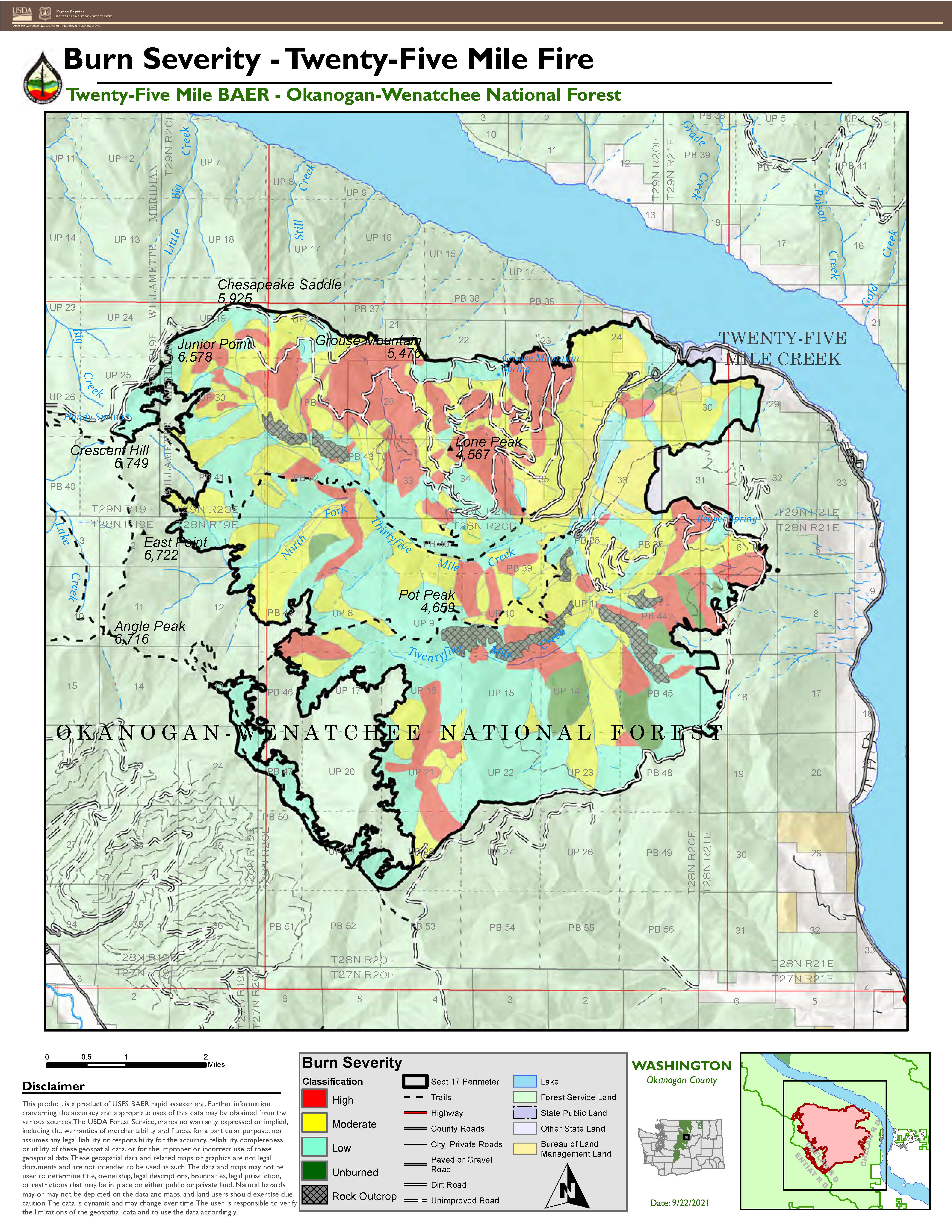
The updated analysis results show 1,784 acres of rock outcrop or unburned lands (9% of area within fire perimeter), 8,603 acres of low severity (39%), 7,108 acres of moderate (32%), and 4,570 acres of high (21%). These results are not drastically different than the hand-mapping results.
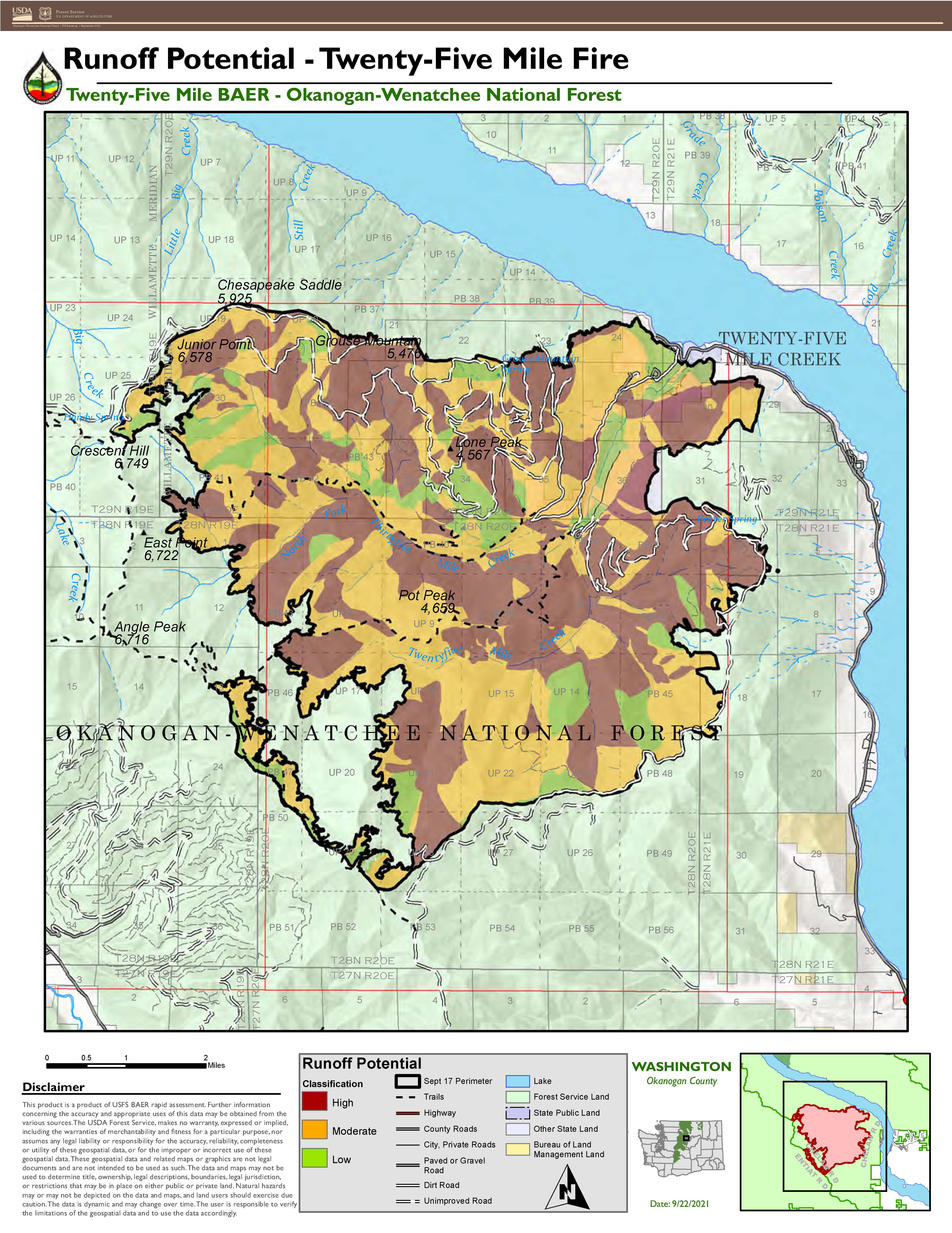
With an updated burn severity map, the team created a runoff potential map. Inputs to this map included the soil burn severity, hydrologic soil groups, rock outcrops, and known water repellent areas, either as a result of the fire or naturally occurring. These inputs modeled together help the BAER team understand where increased runoff is likely to occur. This further analysis was deemed necessary given that the area of re-burn within this fire was substantial and soil burn severity alone is likely to underestimate magnitude of runoff events.
The BAER team determined that 85% of the burned area has a moderate or high runoff potential, so land managers and private landowners should take warning to be prepared to see an increase in flooding and debris flows.
Both map products are available in JPEG and PDF format on the TwentyFive Mile BAER InciWeb site (https://inciweb.nwcg.gov/incident/7846/) or Central Washington Fire Recovery (http://www.centralwashingtonfirerecovery.info/).
Burn Severity and Runoff Potential Mapping Completed
Related Incident:
Publication Type: Announcement
The Burned Area Emergency Response (BAER) team completed mapping burn severity for the area affected by the Twentyfive Mile Fire. Due to persistent cloud and smoke cover, repeated satellite image acquisitions that are usually used to aid in soil burn severity mapping were unusable. The team instead relied primarily on field observations to develop the map. Determining burn severity is an important step in the rapid assessment process, allowing a team to prioritize field reviews and identify increased risks to critical values within or downstream of the burned area. The resulting map displays burn severity in four categories: areas of unburned, low, moderate, or high.
The Twentyfive Mile Fire burned around 22,065 acres. 5% was identified as unburned or rock outcrop, 40% low severity, 35% moderate, and 20% high.Once the burn severity map was complete, the team considered additional data to develop a runoff potential map. Inputs to this map included the soil burn severity, hydrologic soil groups, rock outcrops, and known water repellent areas, either as a result of the fire or naturally occurring. These inputs modeled together help the BAER team understand where increased runoff is likely to occur. This further analysis was deemed necessary given that the area of re-burn within this fire was substantial and soil burn severity alone is likely to underestimate magnitude of runoff events.
The BAER team determined that 88% of the burned area has a moderate or high runoff potential, so land managers and private landowners should take warning to be prepared to see an increase in flooding and debris flows.
To view the maps follow the links below.
Twentyfive Mile BAER Burn Severity Mapping Process
Related Incident:
Publication Type: Announcement
One of the first tasks a Burned Area Emergency Response (BAER) team undertakes is a soil burn severity map. Typically, BAER Teams use satellite imagery comparisons of pre- and post-fire vegetation condition to develop preliminary estimates of soil burn severity and identify areas of interest (see https://fsapps.nwcg.gov/baer/). Using information collected in the burned area, this preliminary estimate is refined into a finalized soil burn severity map.
For the TwentyFive Mile Fire, however, persistent cloud and smoke cover and timing of satellite orbits made obtaining clear imagery of the burned area impossible. Instead of starting from satellite-derived estimates of severity, soil scientists will rely solely on ground-based observations. They will collect information on ground cover, canopy consumption, intact roots, and water repellency to inform burn severity mapping.
While the precision provided by the satellite process will not be present in this product, the manually derived map will still categorize burn severity into four classes: unburned, low, moderate, or high. Mapping will be of sufficient quality to feed subsequent modeling processes related to hydrology, debris flows, and runoff potential.

Soil burn severity map derived from satellite imagery.

Forest Service BAER Program Overview
Related Incident:
Publication Type: Announcement
BAER Objectives:
- Determine whether imminent post-wildfire threats to human life and safety, property, and critical natural or cultural resources on National Forest System lands exist and take immediate actions, as appropriate, to manage the unacceptable risks.
- If emergency conditions are identified, mitigate significant threats to health, safety, human life, property and critical cultural and natural resources.
- Prescribe emergency response actions to stabilize and prevent unacceptable degradation to natural and cultural resources, to minimize threats to critical values resulting from the effects of a fire, or to repair/replace/construct physical improvements necessary to prevent degradation of land or resources.
- Implement emergency response actions to help stabilize soil; control water, sediment and debris movement and potentially reduce threats to the BAER critical values identified above when an analysis shows that planned actions are likely to reduce risks substantially within the first year following containment of the fire.
- Monitor the implementation and effectiveness of emergency treatments that were applied on National Forest System lands.
BAER Funding:
Weather Safety
Related Incident:
Publication Type: Announcement
Forecasted weather this weekend may bring significant rain to the Twentyfive Mile Fire burned area. For their safety, communities need to monitor local weather reports and public safety bulletins, local road closures, emergency notifications, weather alerts, follow local county and city advisories, and act accordingly. Current weather and emergency notifications can be found at the National Weather Service (NWS), Spokane (OTX) (https://www.weather.gov/otx/) website.
Use a weather radio or smart phone weather app that monitors all hazards alerts issued by the NOAA-National Weather Service.
Prepare for rainstorms by practicing evacuations prior to real events. Be prepared to evacuate if county or city emergency officials determine that flooding and debris flows are expected which could pose an increased threat to human life, safety, and property.
Know and be alert to environmental signs of dangerous weather conditions and be prepared to take action that can save lives.
Understand that all drainages within and downstream of burned areas can produce flash flooding.
If you find yourself in a flood, climb to safety (seek higher ground).
Even if the water on a road appears shallow enough to cross, don’t try by vehicle or foot. Water hides dips in the road – worse yet, there may be no road left as flooding can scour away the surface and ground beneath a road.
Forest Service BAER Team Begins Assessment on Twentyfive Mile Fire
Related Incident:
Publication Type: News
CHELAN, WA: A Burned Area Emergency Response (BAER) team was recently organized by the Okanogan-Wenatchee National Forest to begin an assessment of the Twentyfive Mile Fire burning outside Chelan, WA. BAER teams conduct rapid assessments that evaluate post-fire conditions and determine the potential for increased flooding, sediment flows, and rockslides.
BAER teams consist of many disciplines including hydrologists, geologists, soil scientists, road engineers, botanists, biologists, and archeologists from both federal and state agencies. The team will first survey the burned area and collect field data. BAER teams use this information to produce a “Soil Burn Severity” map and inform modeling. Determining soil burn severity is the first step in assessing potential watershed impacts to values that may be at-risk following a wildfire.
BAER teams then produce a report that describes post-fire conditions along with recommended emergency stabilization measures and actions. The team then presents its findings to the Forest Supervisor and coordinates with interagency cooperators.
BAER emergency stabilization efforts are focused on the protection of human life and safety, property, and critical cultural and natural resource values on National Forest System Lands.
The Twentyfive Mile Fire BAER assessment team anticipates that it will take approximately two weeks to complete their burn area assessment.