
Prescribed Burn planned for October 19 2021
Related Incident:
Publication Type: News
On October 19, 2021 the Texas A&M Forest Service will be conducting a prescribed burn on Camp Swift Army National Guard Readiness Center. We will be burning approximately 250 acres in the northwest corner of the property consisting of grass and established trees. These units are being burned to manage hazardous fuel build-up and increase local ecosystem health to benefit the established Loblolly pines in the area. Winds are forecasted to be out of the southeast which could cause some smoke impacts on the community of Elgin. This burn will be held in conjunction with the Capital Area Interagency Wildland Academy (CAIWA) and provide training opportunities for local resources and the participants of the ignitions operations class and the engine operator class.
Media are invited to attend, and should arrive at CAIWA academy at 11:00 a.m and will be escorted on the burn by Public Information Officers from the academy.
October 12 2021 S130190 Firefighter Training
Related Incident:
Publication Type: News
October 12, 2021
5:00 p.m.
Basic Firefighting Training
The first of two 5-day Introduction to Firefighting and Wildland Fire Behavior courses, that spend 3-days in the classroom and 2-days in a hands-on field session, was completed today during this year's CAIWA. In this class students are introduced to many subjects including wildland firefighting techniques, suppression equipment, and safety.
During this field session a prescribed burn was planned on a 3-acre pine unit but due to high humidity and moderate precipitation, the burn was not able to occur. Teachers used this opportunity to discuss how firing operations are influenced by weather and fuel characteristics. The students were able to gain experience using hand tools and working in an organized hand crew. 
October 12 2021 S219 Ignition Operations
Related Incident:
Publication Type: News
October 12, 2021
11:30 a.m.
Ignition Operations
The last day of the the 3-day Ignition Operations course is a field session to let students have hands-on experience using various ignition tools commonly used in wildland firefighting. These tools include devices such as the fusee, drip torch, and flare pistol.
During the field session of the first of two S-219 courses, planned at this years CAIWA, a 61-acre grass burn unit had been scheduled to occur. Unfortunately, due to high humidity and light precipitation, the grass did not ignite. Students were able to discuss the important role fuel characteristics and weather play in prescribed fire and strategic ignitions during wildfires.
WildfireAssociated Landslide Emergency Response Team Report
Related Incident:
Publication Type: News
Wildfire-Associated Landslide Emergency Response Team Report
See link below
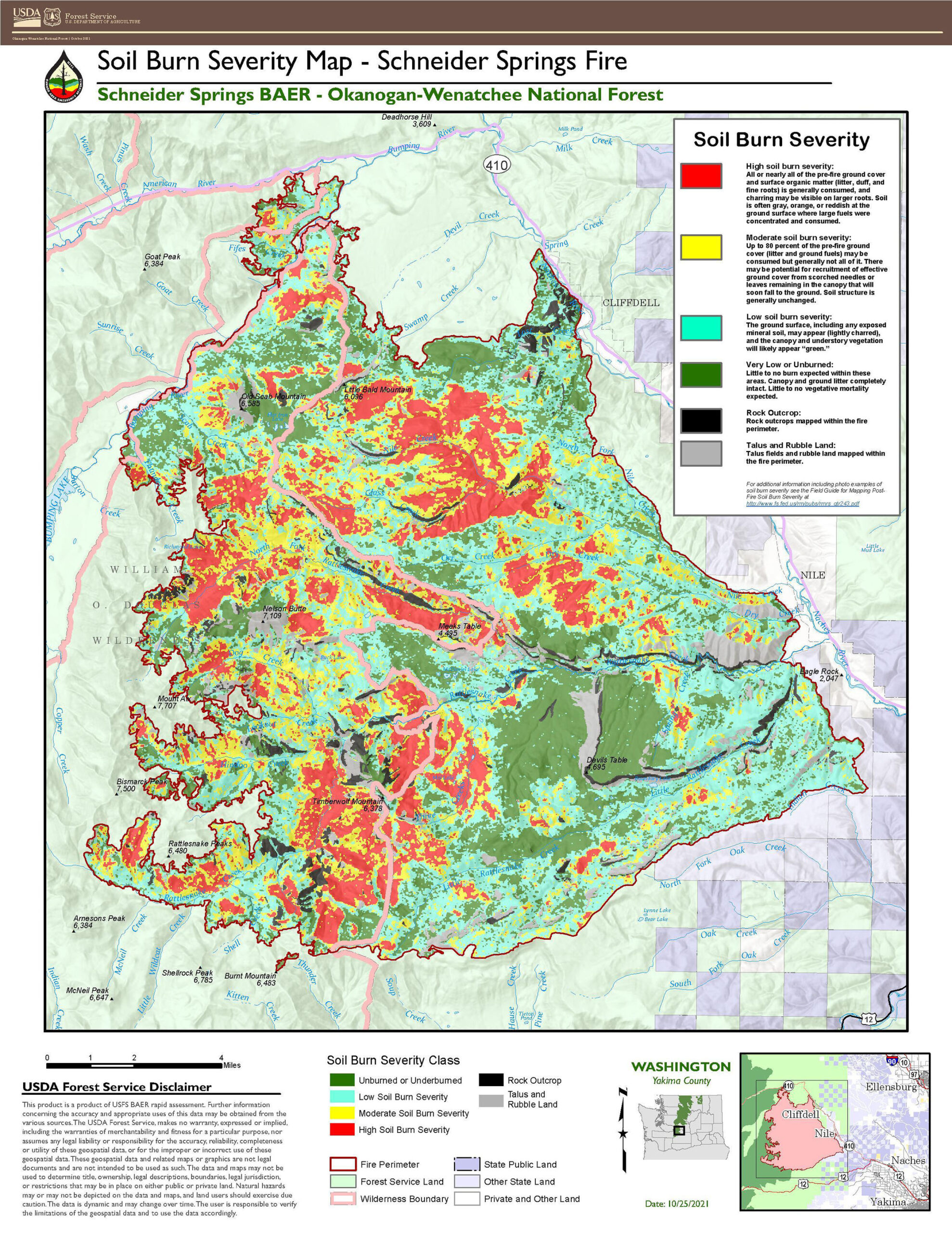
KMZ Data File Available for Schneider Springs Fire Soil Burn Severity
Related Incident:
Publication Type: News
KMZ Data File Available for Schneider Springs Fire Soil Burn Severity:
Map:

- A KMZ file is also available to view the map in greater detail in Google Earth (and many other mapping programs): Download the KMZ zip file, then double-click it to extract the KMZ file and save to your computer. Open the Google Earth program. [If you don’t already have Google Earth, you can download and install it for free HERE.] Drag the KMZ file onto the Google Earth program icon or main screen (or in Google Earth, click File, Import and select the KMZ file). After the KMZ file loads, you can zoom way in for more detail, change the angle of view, show, or hide each burn severity level, and adjust transparency of levels.
Additional Information on Soil Burn Severity Levels:
Low severity- These zones where subjected to predominantly an understory burn that consumed approximately 10- 30% surface vegetative ground cover. Black charring of litter intermixed with grey ash is present. Hydrophobicity is generally absent but there are areas that are extremely dry that experienced weak hydrophobicity.
Moderate severity- Tree canopy cover of 50-80% usually has been consumed. The majority of the ground cover has been consumed with approximately 30 - 15% vegetative ground cover being retained. Grey ash is predominantly present, larger diameter organic matter material of .25-.5 inches is consumed, and soils are strongly hydrophobic. This indicates that high levels of heat were introduced to the soil. These sites are expected to be a source of ash, infiltrations rates will decline, runoff will increase, and soil loss will be accelerated.
High severity- Usually all tree canopy cover has been consumed of 90% or greater. Ground cover has been fully consumed with approximately 5-10% coarse woody debris material remaining. Finer organic material and woody material .5-1 inch has been fully consumed, ash is deep and generally grey, and soils are strongly hydrophobic. Infiltration will be reduced drastically, and accelerated soil loss is predicted to occur. High levels of ash will be immobilized from these sites.
Field Guide for Mapping Post-Fire Soil Burn Severity
Schneider Springs Fire Runoff Potential Map:

Schneider Springs PostFire BAER Soil Burn Severity Map Released
Related Incident:
Publication Type: Announcement
SCHNEIDER SPRINGS POST-FIRE BAER SOIL BURN SEVERITY MAP RELEASED
USDA Forest Service Burned Area Emergency Response (BAER) is a multi-disciplinary team that assesses post-fire impacts on federal lands following significant wildfires. The role of the assessment team is to characterize fire effects within the burned area to identify imminent post-fire threats to human life, safety, property, infrastructure, and critical natural and cultural resources on National Forest System (NFS) lands and recommend emergency response actions designed to mitigate identified risks. After the assessment, Okanogan-Wenatchee National Forest land managers establish an organization to implement protective and stabilization treatments that will be approved by the Forest Service Regional and National offices.
The BAER team began their assessment immediately after the fire threat passed. Their focus was on direct effects to the burned landscape caused by the fire, rather than from fire activities which are the responsibility of the Incident Management Team (IMT) assigned to the fire. Post-fire effects such as loss of vegetation and change in soil stability commonly increase the likelihood of threats that include accelerated soil erosion, increased sediment delivery, flooding, and debris flows.
BAER specialists recently completed their field data evaluation to produce the Soil Burn Severity (SBS) map for the 113,689-acre Schneider Springs Fire. The map and the data delineated Unburned/Very Low, Low, Moderate and High SBS categories. Across the Schneider Springs burned area, approximately 21% of the fire is Unburned; 35% Low SBS; 19% Moderate SBS; and 17% High SBS. The remaining area was mapped as rock.
The acreage of landownership within the Schneider Springs Fire perimeter: 101,320 acres of Okanogan-Wenatchee National Forest (OWF) land 44,856 acres of the 101,320 OWF acres are wilderness; 11,872 acres of Washington State land; and 497 acres of private/other lands.
It is important to note the SBS map product is an estimate of fire effects on soils and not direct effects to vegetation. SBS characterizes the soil surface and below-ground impact, whereas effects on vegetation are estimates of mortality based primarily on changes in vegetation canopy. Changes in overhead and understory vegetation canopy are often used as initial indicators of overall burn severity, but do not necessarily coincide with SBS.
Changes in ground cover, water repellency, and soil physical/biological conditions guide the interpretations to determine a soil severity burn level. Water repellency can occur naturally in some soils and changes as a function of fire are frequently discussed as a post-fire effect. Fire can increase the strength and depth of water repellent layers in soil, considerably increasing post-fire rain runoff and may extend time for recovery for those soils.
A low category of soil burn severity indicates that there was a partial consumption of fine fuels and litter coverage remains, to some extent, on the soil surface. Residence time at the soil surface in low areas was short, leaving root systems and structure intact. Recovery time in the low category will vary based on ecological community but is expected to be relatively short.
A moderate category of soil burn severity indicates consumption of litter and fine fuels at the soil surface. In forested communities, the heat from moderate severity fire may result in water repellant conditions at the mineral soil surface. The canopy in the moderate forested system is browning and it is expected that trees in this area will drop needles and leaves that can provide some litter cover at the soil surface. In these systems, recovery can take longer for tree species to reestablish.
Moderate soil burn severity category in lower elevation communities indicates complete consumption of shrub cover that can but does not necessarily result in water repellant conditions at the soil surface. Several shrub species in the lower elevation communities do re-sprout from their burned root crowns after fire and recovery time will be variable. Moderate soil burn severity category in the lower elevation shrub communities that did not express water repellant behavior can still result in a rain runoff potential category of high as a result of the soils inherent qualities and the removal of effective ground cover.
A high soil burn severity category is the result of higher intensity fire behavior or longer residence time at the soil surface. This category is found in forested or dense Woodland communities and the litter and fuels, including an overstory canopy, that is consumed by the fire. The soil structure is weakened, roots are charred, and water repellant soil conditions can persist through the upper horizon of mineral soil. Recovery time in these conifer systems can be significantly longer
The Schneider Springs BAER assessment team used initial remote sensing imagery with field-validated soils data to produce the final SBS map. The BAER team and the US Geological Survey (USGS) both use the SBS map as an analysis tool to estimate post-fire erosion with subsequent sediment delivery, stream flows and debris flow probabilities.
Both the Schneider Springs Fire soil burn severity and runoff maps can be downloaded at the “Schneider Springs Post-Fire BAER” InciWeb site (https://inciweb.nwcg.gov/incident/7860/) as a JPEG or PDF version under the “Maps” tab.
SPECIAL BAER SAFETY MESSAGE: Everyone near and downstream from the burned areas should remain alert and stay updated on weather conditions that may result in heavy rains and increased water runoff. Flash flooding may occur quickly during heavy rain events and residents and forest visitors need to be prepared to take action. Current weather and emergency notifications can be found at the National Weather Service website: https://www.weather.gov/pdt/.
FS BAER Team Begins Schneider Springs Fire Assessment
Related Incident:
Publication Type: Announcement
FOREST SERVICE BAER TEAM BEGINS POST-FIRE ASSESSMENT OF SCHNEIDER SPRINGS FIRE
After a large wildfire, special actions may be necessary to provide for public and community safety and protect critical natural and cultural resources on federal managed lands. For example, loss of vegetation exposes soil to erosion; water runoff may increase and lead to flooding. Sediment may move downstream damaging roads and infrastructure or put endangered species and cultural resources at risk. The Burned Area Emergency Response (BAER) program evaluates these situations on federal lands to help guard the safety of National Forest (NF) visitors and employees, protect federal property, and critical natural or cultural resources from further damage.
A BAER team has been established by the Okanogan-Wenatchee NF to begin a burned area assessment of the Schneider Springs Fire that recently burned on state, private, and federal lands. The Forest Service BAER team assesses National Forest System (NFS) lands.
BAER assessments are rapid evaluations of the burned area used to identify unacceptable risks on federal lands from post-fire threats and assist land managers in preparing burned areas for potential threats from rainstorms. Teams focus on emergency actions necessary to protect human life and safety, property, and critical natural and cultural resources. They assess potential post-fire impacts to the burned watersheds. Additionally, they coordinate and share information from their assessments with other federal agencies such as the Natural Resources Conservation Service (NRCS, National Weather Service (NWS) and US Geological Survey (USGS), state agencies, and local affected counties. NRCS is a federal agency that has post-fire responsibilities on private lands both within and downstream of burned areas.
The Schneider Springs Post-Fire BAER Team is assessing the potential post-fire effects related to life and safety, property to include roads and trails, along with natural, cultural and heritage resources. Specialized supporting disciplines on this team include hydrology, soils, geology, engineering, biology, recreation and archeology all being supported by remote sensing and geographic information system (GIS) resources.
BAER assessment teams collect data during ground and aerial surveys and create maps using GIS and modeling to evaluate post-fire risks. The first step in the BAER assessment process is taking pre-fire and post-fire satellite imagery and data collected during ground surveys to produce a soil burn severity map. The soil burn severity provides baseline information to determine changed watershed conditions for assessing potential watershed impacts from wildfires. This information is compiled and presented to NF leadership along with recommended emergency stabilization treatments and actions in a BAER assessment report.
Rainfall runoff is sometimes, but not always, increased in burned areas. The Forest Service BAER assessment report will be shared with interagency cooperators who work with downstream private homeowners and landowners to prepare for potential post-fire flooding and debris flow impacts. Homes or businesses that could be impacted by flooding from federal land that result from wildfires may be eligible for flood insurance coverage from the National Flood Insurance Program (NFIP). Information about NFIP is available through FEMA at www.fema.gov/national-flood-insurance-program or www.floodsmart.gov/wildfires. Other flood preparedness information is available at www.ready.gov/floods at www.floodsmart.gov/.
SPECIAL NOTE: Everyone near and downstream from the burned areas should remain alert and stay updated on weather conditions that may result in heavy rains and increased water runoff. Flash flooding may occur quickly during heavy rain events-be prepared to take action. Current weather and emergency notifications can be found at the National Weather Service website: https://www.weather.gov/pdt/.Engagement from stakeholders
Related Incident:
Publication Type: Announcement
Many people have expressed an interest in the BAER assessment process for the Schneider Springs Fire. The BAER team leadership recently met with a few dozen stakeholders and shared information about what the Forest Service BAER process is, what it isn't, and how they can provide input and engage with the local Ranger District office on longer-term restoration projects. That meeting was recorded and is available on YouTube: https://www.youtube.com/watch?v=mKEzyb0DyZs
As part of that discussion, we provided a link to a survey (Microsoft Forms) asking for input from non-Forest Service stakeholders. This form asks about items you consider critical values that you think the BAER team (if appropriate) or the local District should consider in its recovery plans. Visit the survey here: https://forms.office.com/g/FE7GyVLNZN
An Overview of the BAER Program
Related Incident:
Publication Type: News
See the linked PDF (below) for an overview of the Forest Service Burned Area Emergency Response (BAER) program.
Most Current Closure Info
Related Incident:
Publication Type: Closures
The closure area has been reduced to the perimeter of the fire. Please see links below that will take you to the Okanogan-Wenatchee NF's website for more information.