
New Start Confirmed on Cooks Peak Fire
Related Incident: Cooks Peak
Publication Type: Announcement
New Start Confirmed - Cooks Peak Fire
We have confirmed a new start on the southeast side the Cooks Peak Fire. The fire is burning in a single tree and initial attack firefighters are currently responding. The smoke is visible from NM HWY 120 just west of mile marker 21.
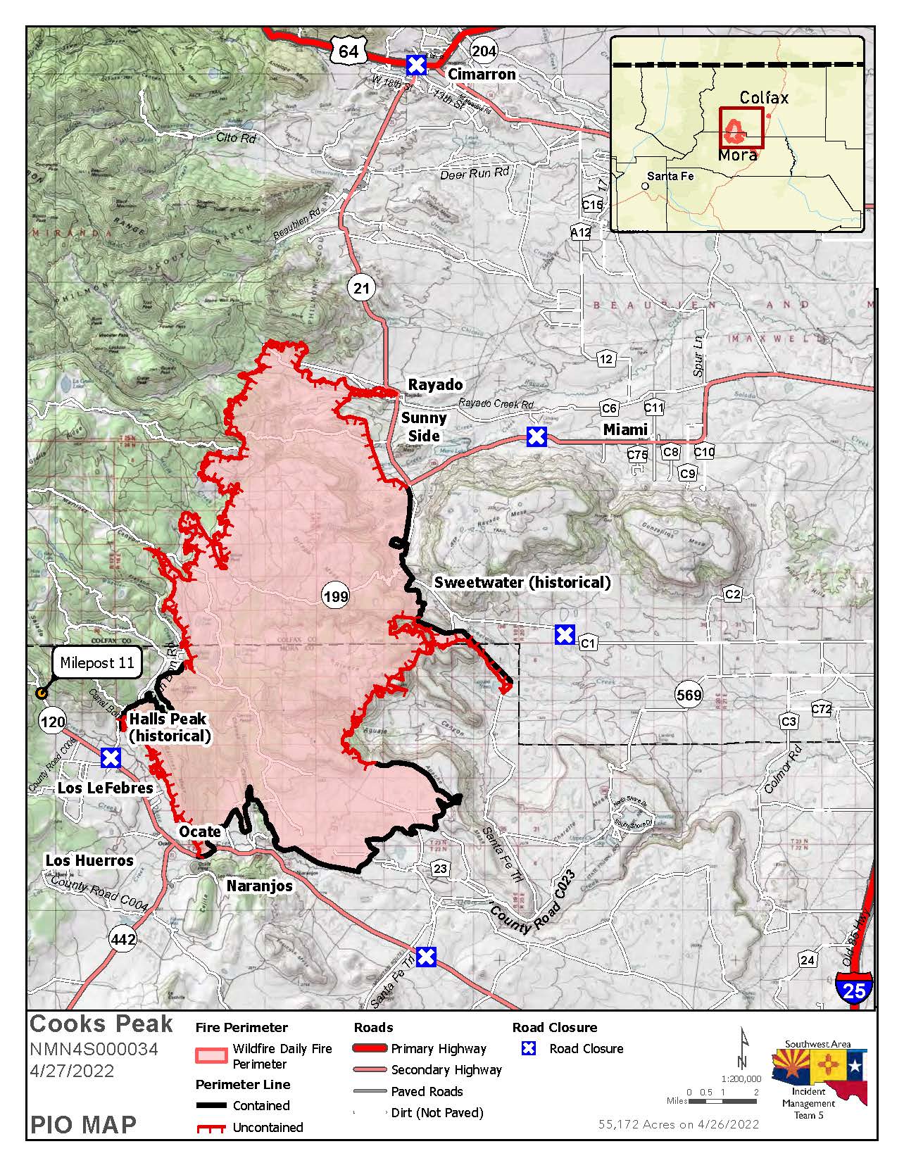
Cooks Peak Morning Update for April 27 2022
Related Incident: Cooks Peak
Publication Type: News
Firefighters continue work to increase containment
Active fire behavior will continue as high winds return and temperatures increase
Morning Update 4/27/2022Acres: 55,172 acres
Location: North of Ocate NM, approximately 46 miles north of Las Vegas, NM
Containment: 33%
Start Date: Sunday, April 17, 2022
Cause: Human, under investigation
Fuels: ponderosa pine, oak brush and grass
Current Evacuations for Mora and Colfax Counties:
Mora County – GO: Los LeFebres and Los Huerros, residents east of County Road 009 and north of NM Highway 120. Set: Los Cocas
The Mora and Colfax County Sheriff’s Offices are using the Ready! Set! Go! program for evacuation status that provides information on evacuation and evacuation preparation.
An Evacuation center is set up at Old Memorial Middle School, 947 Old National Rd, Las Vegas; and Colfax County Fairgrounds, 16 Airport Road, Springer.
Livestock: Residents can evacuate livestock to the Colfax County Fairgrounds. If residents from Mora need a place for horses, the Taos Rodeo Grounds is available. Contact: Livestock Inspector Ruben Baca 505-770-1490.
Fire Update:
Active fire behavior resumed on the Cooks Peak Fire yesterday. Yesterday, on the north end of the fire, hotshot hand crews worked to reinforce containment lines as aerial resources provided assistance throughout the day. On the eastern side of the fire, wildland fire crews continued to improve hand line and began suppression repair work to include brush chipping, dozer line repair and road grading, where needed. Fire crews completed a successful firing operation through Aguate Canyon, improving containment along the southern perimeter.
Today, ground crews and aerial resources will continue to work steadily to hold the perimeter within the existing footprint, increase containment and perform mop-up operations. Crews will also conduct suppression repair where conditions permit. On the southern end of the fire, crews will continue to monitor and patrol the Gallinas Mesa area and the lines north of Naranjos. Firefighters will continue building direct line where needed and aviation resources will support with potential aerial ignitions, as weather and wind permit. Hand crews on the northern and eastern edge of the fire will continue working to gain access to areas still burning hot due to fuel concentrations within pinyon and juniper stands.
Wildland firefighting tactics will continue to vary with changing fuels, topography and weather. As the region experiences continued breezy to gusty winds and decreased moisture, fuels will dry rapidly, increasing the potential for active fire behavior. As these drying trends continue, conditions will be conducive for direct and indirect tactics including fire line construction and hand ignition to control fire lines. The use of aerial resources will be based on safe wind conditions.
Weather: Isolated/scattered dry thunderstorms will move across the fire area, accompanied by gusty winds and potential for lightning strikes. Temperatures will range from high 60s to low 70s today. The region will experience an elevated fire threat later in the week as the next Pacific storm system approaches.
Highway Closures: New Mexico Highway 120 is closed from mile marker 26 to 3 miles west of Ocate. NM 21 is closed from mile marker 1, south of Cimarron to mile marker 18 west of Miami. Motorists are advised to delay travel or to seek alternate routes. Visit https://nmroads.com/mapIndex.html for additional information.
Fire Restrictions: New Mexico is in a drought. Even a small spark can start a wildfire. Fire restrictions are implemented to help reduce the chance of a wildfire. The New Mexico State Forester has implemented statewide fire restrictions. Smoking, fireworks, campfires open burning and open fires are prohibited. For more information see https://www.emnrd.nm.gov/sfd/forestry-news/ The Bureau of Land Management, Farmington District has also implemented fire restrictions. Fireworks, campfires, smoking and operating machinery, including off road OHV use are restricted. Visit Fire Restrictions | Bureau of Land Management (blm.gov) for details.
More Information:
Inciweb: https://inciweb.nwcg.gov/incident/8066/
New Mexico Fire information: https://nmfireinfo.com/
Smoke Outlook: https://outlooks.wildlandfiresmoke.net/outlook/b335b9f4
Facebook: https://www.facebook.com/CooksPeakFireInfo/
Evacuations: https://www.facebook.com/moracountysheriffoffice/
Information on Calf Canyon Fire:
Phone: 505-356-2636, phone answered from 8 a.m. to 8 p.m.
Inciweb: https://inciweb.nwcg.gov/incident/8069
Cooks Peak Fire Smoke Outlook 42722
Related Incident: Cooks Peak
Publication Type: News
Cooks Peak Fire Smoke Outlook 4-27-22 to 4-28-22.

BLM Fire Prevention Order 4272022
Related Incident: Cooks Peak
Publication Type: News
FIRE PREVENTION ORDER# NMF00000-22-01
Pursuant to 43 Code of Federal Regulations (CFR) §92l2.2(a), the following acts are prohibited on all lands administered by the BLM Farmington District within the counties of San Juan, Rio Arriba, Taos, Santa Fe, McKinley, Sandoval, Colfax, Union, Mora, Harding, Quay, and San Miguel.
This order shall go into effect at 12:0l a.m., MDT, April 27, 20222 and will remain in effect until further notice.
Prohibited Acts:
1. Building, maintaining, attending, or using a fire, campfire, charcoal, coal, or wood stove, including in campgrounds and picnic areas. Allowed: The use of stoves fueled by pressurized liquid or gas (can be turned off) within areas cleared of flammable materials at least 10 feet in diameter.
2. Smoking except within an enclosed vehicle or building, developed sites and areas, or while stopped in an area at least 3 feet in diameter that is barren or cleared of all flammable materials.
3. Operating a chainsaw or any other internal or external combustion engine without a USDA or SAE approved spark arrester properly installed and working, a chemical pressurized fire extinguisher of not less than 8 ounces capacity by weight, and one round point shovel with an overall length of at least 36 inches.
4. Possessing or using a motor vehicle off roads, except routes in areas open to OHV travel and except when parking in an area devoid of vegetation within 10 feet of the roadway.
5. Any “hot work” conducted by authorized contractors or permittees for, by or on BLM will follow permit stipulations provided by the BLM.
Fireworks and exploding targets are prohibited on all BLM lands in NM under Fire Prevention Order #NM910-22-01.
All BLM NM Fire Prevention Orders can be found at: https://www.blm.gov/programs/public-safety-andfire/fire-and-aviation/regional-info/new-mexico/fire-restrictions
Monitor the BLM New Mexico social media pages at: Twitter: https://twitter.com/BLMNewMexico or Facebook: https://www.facebook.com/BLMNewMexico/
Exempted:
Any federal, state, local and/or military employee acting within the scope if his/her duties; members of any organized rescue or firefighting force performing official duty; and persons, agencies, municipalities or companies with a written permit that specifically authorizes the otherwise prohibited act. An exemption does not absolve an individual or organization from liability or responsibility for any fire started by an exempted activity.
Penalties:
Pursuant to Title 43 CFR §9212.4, any violation of this order is subject to punishment by a fine of not more than $1,000 or imprisonment of not more than 12 months or both. Restitution for total costs of fire suppression or damage will be borne by the violator. Information regarding these fire restrictions may be obtained by calling the Farmington District Office at (505) 564-7600. Dated this 26th day of April 2022, at Farmington, New Mexico.
Signed order available for download below.
Air Quality Alert for Cooks Peak Fire 4262022
Related Incident: Cooks Peak
Publication Type: Announcement
Air Quality Alert
The National Weather Service has issued an Air Quality Alert for smoke due to large wildfire in northern New Mexico.
See more: https://forecast.weather.gov/product.php?site=NWS&issuedby=abq&product=AQA&glossary=0
Cooks Peak Fire Firing Operations Underway 4262022
Related Incident: Cooks Peak
Publication Type: Announcement
Announcement:
Cooks Peak firefighters are conducting firing operations to secure unburned fuel pockets near the Colfax/Mora County line along the west side of Highway 21. Increased smoke and fire activity may be visible.
Cooks Peak Fire Evacuation Status Updates for Colfax County 4262022
Related Incident: Cooks Peak
Publication Type: Announcement
Cooks Peak Fire Morning Update for April 26 2022
Related Incident: Cooks Peak
Publication Type: News
Firefighters continue to make progress with containment
Fire behavior will moderate today with arrival of snow, but remains active
Morning Update 4/26/2022Acres: 54,021 acres
Location: North of Ocate NM, approximately 46 miles north of Las Vegas, NM
Containment: 18%
Start Date: Sunday, April 17, 2022
Cause: Unknown, under investigation
Fuels: ponderosa pine, oak brush and grass
Current Evacuations for Mora and Colfax Counties:
Mora County – GO: Los LeFebres and Los Huerros, residents east of County Road 009 and north of NM Highway 120. Ready: Lucero and Los Cocas, residents west of County Road 009 and north of Highway 120. The Mora and Colfax County Sheriff’s Offices are using the Ready! Set! Go! program for evacuation status that provides information on evacuation and evacuation preparation.
Evacuation center is set up at Old Memorial Middle School, 947 Old National Rd, Las Vegas; and Colfax County Fairgrounds, 16 Airport Road, Springer.
Livestock: Residents can evacuate livestock to the Colfax County Fairgrounds. If residents from Mora need a place for horses, the Taos Rodeo Grounds is available. Contact: Livestock Inspector Ruben Baca 505-770-1490.
Although Monday’s moisture provided favorable conditions for fighting fire, winds and drying conditions are predicted for the next several days. As wind increases and fuels dry, fire behavior increases in intensity. So although the moisture brought some relief, drought stricken fuels and high winds will again challenge firefighters. Today crews will continue direct hand line construction along the west and northwest areas of the fire. These hotshot crews will camp out to maximize their efficiency and effectiveness. Engine crews working the eastern flank of the burned area will continue with mop-up and cold trailing along previously built dozer lines. If conditions allow, unburned fuels will be ignited south of Sweetwater and west of County Road 21 to strengthen containment lines where rugged topography presents challenges. Some suppression repair will begin northeast of Naranjos where the fire is contained.
On the ground tactics must vary with fuels and conditions. Every effort is being made to keep this fire footprint as small as possible. With yesterday’s moisture, “there is not a lot of heat established right now, it is a good day to go direct”, said Arthur Gonzalez, Fire Behavior Analyst with Southwest Incident Management Team 5.
Weather: Sunday featured moderate fire weather conditions, due to cooler temperatures, lighter winds, and more clouds over the Cooks Peak Fire. Last night, a cold front pushed in from the north, bringing rain and higher elevation snow showers. Snow accumulations range from 1-4 inches for the fire area. Winds remain relatively light through the day, shifting from easterly to southerly through the afternoon.
Highway Closures: The Cooks Peak Fire closed a portion NM120, from mile marker 14, three miles west of Ocate to mile marker 26, five miles east of Naranjos and at the junction of highway 442 and 120. NM21 is also closed from mile marker 0 in Cimarron to mile marker 34 in Springer. Motorists are advised to delay travel or to seek alternate routes. Visit https://nmroads.com/mapIndex.html for additional information.
More Information:
Inciweb: https://inciweb.nwcg.gov/incident/8066/
New Mexico Fire information: https://nmfireinfo.com/
Smoke Outlook: https://outlooks.wildlandfiresmoke.net/outlook/b335b9f4
Facebook: https://www.facebook.com/CooksPeakFireInfo/
Information on Calf Canyon Fire:
Phone: 505-356-2636, phone answered from 8 a.m. to 8 p.m.
Inciweb: https://inciweb.nwcg.gov/incident/8069
Smoke Outlook NE New Mexico Cooks Peak Fire 426 427
Related Incident: Cooks Peak
Publication Type: News
Smoke Outlook - Northeast New Mexico Cooks Peak Fire for April 26-27. 2022
Fire
The Cooks Peak Fire is estimated at 54,021 acres with 18% containment.
Smoke
Overall good air quality conditions expected today in the area of the outlook. Some lingering moderate smoke in the area around Miami. Winds out of the south-southwest 15-20. Winds increasing throughout the week.
- - - - - - - - - - - - - - - - - - - - - - - - -
Fuego
El incendio Cooks Peak se estima actualmente en 54,021 acres y está contenido en un 18%.
Humo
En general, hoy se esperan buenas condiciones de calidad de aire en el área de la perspectiva. Algo de humo moderado persistente en el área alrededor de Miami. Vientos del sur-suroeste 15-20mph. Aumentarán los vientos durante la semana.
Full release available for download in English and Spanish, below.
Cooks Peak Morning Update for April 25 2022
Related Incident: Cooks Peak
Publication Type: News
Cooks Peak Fire community meeting scheduled for 7 p.m. tonight
Fire behavior will moderate today with arrival of snow, but remains active
Morning Update 4/25/2022
Acres: 51,982 acres
Location: North of Ocate NM, approximately 46 miles north of Las Vegas, NM
Containment: 9%
Start Date: Sunday, April 17, 2022
Cause: Unknown, under investigation
Fuels: ponderosa pine, oak brush and grass
Announcement: The Southwest Area Incident Management Team will host a community meeting on Monday, April 25, 2022, at 7 p.m. to provide updates on the Cooks Peak Fire. The meeting will be held in the Wagon Mound High School Gym at 300 Park Ave., in Wagon Mound. Interested attendees can participate in-person or virtually, via Cooks Peak Fire Facebook Livestream at https://www.facebook.com/CooksPeakFireInfo/.
Livestock: Residents can evacuate livestock to the Colfax County Fairgrounds. If residents from Mora need a place for horses, the Taos Rodeo Grounds is available. Contact: Livestock Inspector Ruben Baca 505-770-1490.
Fire behavior is expected to moderate today with the arrival of colder temperatures, rain and snow. This change in weather should provide an opportunity for crews to gain ground on the fire, but fire behavior will remain active, especially where topography and drought stressed fuels align. Ground crews will continue working hard to secure the northern perimeter, where weather, topography and fire behavior made firefighting especially difficult in previous days. Firing operations will be conducted on the east side from Aguate Canyon to Apache Mesa, if weather allows, which may increase smoke. Crews will continue to secure and hold the fire perimeter. Structural assessments are still underway, and crews will continue to identify any structures impacted by the fire. A temporary flight restriction (TFR) remains in place over the fire area.
The Incident Management Team continues to work closely with the local unit, stakeholders and fire behavior, and mapping specialists to determine the best firefighting tactics and response for the important values in an around the fires area. This assists administrators in determining primary, alternate contingency and emergency firelines to ensure a coordinated response to changing conditions.
Weather: Sunday featured moderate fire weather conditions, due to cooler temperatures, lighter winds, and more clouds over the Cooks Peak Fire. Last night, a cold front pushed in from the north, bringing rain and higher elevation snow showers. Snow accumulations range from 1-4 inches for the fire area. Winds remain relatively light through the day, shifting from easterly to southerly through the afternoon.
Highway Closures: The Cooks Peak Fire closed a portion NM120, from mile marker 14, three miles west of Ocate to mile marker 26, five miles east of Naranjos and at the junction of highway 442 and 120. NM21 is also closed from mile marker 0 in Cimarron to mile marker 34 in Springer. Motorists are advised to delay travel or to seek alternate routes. Visit https://nmroads.com/mapIndex.html for additional information.
More Information:
Inciweb: https://inciweb.nwcg.gov/incident/8066/
New Mexico Fire information: https://nmfireinfo.com/
Smoke Outlook: https://outlooks.wildlandfiresmoke.net/outlook/b335b9f4
Facebook: https://www.facebook.com/CooksPeakFireInfo/