
Cooks Peak Daily Update 512022
Related Incident: Cooks Peak
Publication Type: News
All evacuation levels associated with the Cooks Peak Fire was lifted at 1700 today.
Update 5/01/2022
Acres: 59,359 acres
Location: North of Ocate NM, approximately 46 miles north of Las Vegas, NM
Containment: 97%
Start Date: Sunday, April 17, 2022
Cause: Human, under investigation
Fuels: ponderosa pine, oak brush and grass
The Mora and Colfax County Sheriff’s Offices are using the Ready! Set! Go! (https://www.emnrd.nm.gov/sfd/fire-prevention-programs/ready-set-go-new-mexico/) program for evacuation status that provides information on evacuation and evacuation preparation.
An Evacuation center is set up at Old Memorial Middle School, 947 Old National Rd, Las Vegas. The Colfax County Fairgrounds have been closed.
Livestock: The Taos Rodeo Grounds is available to residents from Mora if they need a place for horses. Contact: Livestock Inspector Ruben Baca 505-770-1490.
Public Meeting: Last night's at Cimarron High School was record and will be available on the Cooks Peak Fire Information Facebook Page: https://www.facebook.com/CooksPeakFireInfo/.
Fire Update: Yesterday, firing operations occurred on the eastern flank of the Cooks Peak Fire to secure additional fireline. Aerial ignitions were utilized to remove the unburned pocket of fuel in Agueje Canyon, and to strengthen containment lines south of Sweetwater. Aviation resources also assisted with water drops to aid fire suppression efforts in the heavily timbered, rugged terrain and challenging topography of the north end of the fire near Urraca Mesa. Mop up and suppression repair work, including returning dozer lines to a more natural state, building water bars where needed and mending fences, occurred in areas where firelines have been secured and the fire is no longer a threat.
Drones were spotted yesterday morning on the southeast side of the fire causing all aerial resources to be grounded. Visit https://www.facebook.com/CooksPeakFireInfo/videos/291847116497757 for additional information. Please remember “if you fly, we can’t”.
Today, there is a high potential for increased fire activity on the Cooks Peak Fire. Art Gonzales, Fire Behavior Analyst, says “Drought stressed fuels and low humidity create conditions for increased fire behavior.” Those conditions, along with Red Flag weather conditions, with 25-30 mph sustained winds and 45-50 mph gusts, combined with large fires to the south and outflow winds from expected storms create unique suppression challenges for Cooks Peak fire crews. Due to high winds, limited aerial suppression will occur in the morning and flights will be grounded in the afternoon for the safety of crews.
Firefighters are working to complete and secure 109 miles of fireline. Today, they will patrol containment lines and work to contain the Cooks Peak Fire within the current footprint while protecting structures, property, and natural resources. Fire crews are securing the southwestern side of Gallinas Mesa and expect to need additional firing operations when weather conditions allow in the next few days to reinforce containment lines. This area is visible from Ocate and Ojo Feliz. Suppression emphasis will be on the active fire areas on the western and northwestern perimeter with hand tools, dozer lines and air support when possible. Crews continue to construct and strengthen containment and mop up where needed.
Weather: On Sunday, winds will decrease slightly, and temperatures climb by a few degrees higher than Saturday. Relative humidity will remain unseasonably dry. On Monday, another critical fire weather day is possible with strong gusty winds and low relative humidity.
Highway Closures: New Mexico Highway 120 remains closed from mile marker 26 to 3 miles west of Ocate due to fire activity and equipment entering the area to support firefighting efforts. Motorists are advised to delay travel or to seek alternate routes. State Road 21 from Polo Ranch to Cimarron is open to local traffic only, and remains closed to through traffic. Visit https://nmroads.com/mapIndex.html for additional information.
Aviation Restrictions: There is a Temporary Flight Restriction over the Cooks Peak Fire. Firefighting aircraft fly at very low altitudes, typically just a couple hundred feet about the ground. This creates the potential for a mid-air collision. Any aircraft entering the fire area, including drones, could lead all firefighting aircraft to be grounded until they have left the fire area. Stay out of the airspace over the Cooks Peak Fire.
Fire Restrictions: Fire restrictions are being implemented to help reduce the chance of a wildfire. The New Mexico State Forester has implemented statewide fire restrictions. Smoking, fireworks, campfires open burning and open fires are prohibited. For more information see https://www.emnrd.nm.gov/sfd/forestry-news/ The Bureau of Land Management, Farmington District has also implemented fire restrictions. Fireworks, campfires, smoking and operating machinery, including off road OHV use are restricted. Visit https://www.blm.gov/programs/public-safety-and-fire/fire-and-aviation/regional-info/new-mexico/fire-restrictions for details.
More Information:
Inciweb: https://inciweb.nwcg.gov/incident/8066/
New Mexico Fire information: https://nmfireinfo.com/
Smoke Outlook: https://outlooks.wildlandfiresmoke.net/outlook/b335b9f4
Facebook: https://www.facebook.com/CooksPeakFireInfo/
Evacuations: https://www.facebook.com/moracountysheriffoffice/
Colfax County: http://www.co.colfax.nm.us/government/sheriff_s_department.php
Cooks Peak Fire Daily Update 4302022
Related Incident: Cooks Peak
Publication Type: News
Containment increases
Winds ease Saturday, critical fire weather returns Sunday
Morning Update 4/30/2022
Acres: 56,276 acres
Location: North of Ocate NM, approximately 46 miles north of Las Vegas, NM
Containment: 56%
Start Date: Sunday, April 17, 2022
Cause: Human, under investigation
Fuels: ponderosa pine, oak brush and grass
The Mora and Colfax County Sheriff’s Offices are using the Ready! Set! Go! (https://www.emnrd.nm.gov/sfd/fire-prevention-programs/ready-set-go-new-mexico/) program for evacuation status that provides information on evacuation and evacuation preparation.
An Evacuation center is set up at Old Memorial Middle School, 947 Old National Rd, Las Vegas. The Colfax County Fairgrounds have been closed.
Livestock: The Taos Rodeo Grounds is available to residents from Mora if they need a place for horses. Contact: Livestock Inspector Ruben Baca 505-770-1490.
Public Meeting: A community meeting is scheduled for Saturday, April 30, at 6:00 p.m. at the Cimarron High School located at 165 N Collison Ave, Cimarron, NM 87714. The meeting will also be live streamed to the Cooks Peak Fire Information Facebook Page: https://www.facebook.com/CooksPeakFireInfo/.
Fire Update: Yesterday, the Cooks Peak Fire experienced Red Flag weather conditions, with 30-40 mph sustained winds and 50-60 mph gusts. Ground resources, including hand crews and heavy equipment, were able to continue making progress across the fire area. Due to extreme winds, aircraft was grounded.
Firefighters patrolled containment lines and worked to make sure the Cooks Peak Fire didn’t move any closer to structures, property and natural resources. Suppression repair work continued in the Gallinas Mesa and Halls Peak area and monitored interior flames and smoke. Crews continued to construct fireline along the western edge and mop up where needed. Hand crews responded to reports of interior smoke near Rayado, on the northeast side of the fire, and monitored the area overnight.
Today, mop up and suppression repair work, including returning dozer lines to a more natural state, building water bars where needed and mending fences, will continue in areas where firelines has been secured and the fire is no longer a threat. Firing Operations may occur on the western flank of the Cooks Peak Fire to secure additional fireline. Aerial ignitions are also planned to remove the unburned pocket of fuel in Agueje Canyon, to strengthen firelines south of Sweetwater, if weather conditions cooperate. Aviation resources will also assist with water drops to help suppress fire in the heavily timbered, rugged terrain and challenging topography of the north end of the fire near Urraca Mesa.
Weather: On Saturday, winds will be lighter, and temperatures climb by a few degrees. Relative humidity will remain unseasonably dry. On Sunday, another critical fire weather day is possible with strong gusty winds and low relative humidity.
Highway Closures: New Mexico Highway 120 remains closed from mile marker 26 to 3 miles west of Ocate due to fire activity and equipment entering the area to support firefighting efforts. Motorists are advised to delay travel or to seek alternate routes. State Road 21 from Polo Ranch to Cimarron is open to local traffic only, and remains closed to through traffic. Visit https://nmroads.com/mapIndex.html for additional information.
Aviation Restrictions: There is a Temporary Flight Restriction over the Cooks Peak Fire. Firefighting aircraft fly at very low altitudes, typically just a couple hundred feet about the ground. This creates the potential for a mid-air collision. Any aircraft entering the fire area, including drones, could lead all firefighting aircraft to be grounded until they have left the fire area. Stay out of the airspace over the Cooks Peak Fire.
Fire Restrictions: Fire restrictions are being implemented to help reduce the chance of a wildfire. The New Mexico State Forester has implemented statewide fire restrictions. Smoking, fireworks, campfires open burning and open fires are prohibited. For more information see https://www.emnrd.nm.gov/sfd/forestry-news/ The Bureau of Land Management, Farmington District has also implemented fire restrictions. Fireworks, campfires, smoking and operating machinery, including off road OHV use are restricted. Visit https://www.blm.gov/programs/public-safety-and-fire/fire-and-aviation/regional-info/new-mexico/fire-restrictions for details.
More Information:
Inciweb: https://inciweb.nwcg.gov/incident/8066/
New Mexico Fire information: https://nmfireinfo.com/
Smoke Outlook: https://outlooks.wildlandfiresmoke.net/outlook/b335b9f4
Facebook: https://www.facebook.com/CooksPeakFireInfo/
Evacuations: https://www.facebook.com/moracountysheriffoffice/
Colfax County: http://www.co.colfax.nm.us/government/sheriff_s_department.php
Cooks Peak Fire Evacuation Update as of 600 PM on 4292022
Related Incident: Cooks Peak
Publication Type: Announcement
The Colfax County Sheriff's Office released an evacuation update for the Cooks Peak Fire at 8:33 pm on 4/29/2022.
Effective at 6:00 PM on the Cooks Peak Fire, Colfax County Sheriff's Office in consultation with Colfax County Emergency Management is placing the following communities in READY Evacuation status:
- Miami
- Philmont Scout Ranch Head Quarters
The following communities in SET Evacuation status:
- Rayado
- Sweetwater
- Sunnyside
The following communities will remain in GO! Evacuation Status:
- Philmont Scout Ranch Back Country West of State Road 21
Full release available below.
Cooks Peak Morning Update for April 29 2022
Related Incident: Cooks Peak
Publication Type: News
Red Flag Conditions Indicate Critical Fire Weather Today
Morning Update 4/29/2022
Acres: 55,978 acres
Location: North of Ocate NM, approximately 46 miles north of Las Vegas, NM
Containment: 54%
Start Date: Sunday, April 17, 2022
Cause: Human, under investigation
Fuels: ponderosa pine, oak brush and grass
Mora County – GO: Los LeFebres and Los Huerros, residents east of County Road 009 and north of NM Highway 120. Set: Los Cocas
The Mora and Colfax County Sheriff’s Offices are using the Ready! Set! Go! program for evacuation status that provides information on evacuation and evacuation preparation. Link: https://www.emnrd.nm.gov/sfd/fire-prevention-programs/ready-set-go-new-mexico/
An Evacuation center is set up at Old Memorial Middle School, 947 Old National Rd, Las Vegas; and Colfax County Fairgrounds, 16 Airport Road, Springer.
Livestock: Residents can evacuate livestock to the Colfax County Fairgrounds. If residents from Mora need a place for horses, the Taos Rodeo Grounds is available. Contact: Livestock Inspector Ruben Baca 505-770-1490.
Public Meeting: A community meeting is scheduled for tomorrow, Saturday, April 30th at 6:00pm at the Cimarron High School located at 165 N Collison Ave, Cimarron, NM 87714. The meeting will also be live streamed to the Cooks Peak Fire Information Facebook Page: https://www.facebook.com/CooksPeakFireInfo/.
Fire Update:
Yesterday, the Cooks Peak Fire exhibited moderate fire behavior as Red Flag Warning conditions enabled fire spread in isolated pockets of heat. Progress continued on the ground utilizing a mixture of hand crews, heavy equipment, and aerial resources.Today, strong winds and low humidity will create the potential for increased fire spread, spotting and torching in unburned fuels.
Other risks associated with the fire area include uprooted or snapped trees, downed power lines, and blowing ash and dust. These risks will hinder firefighting operations and create safety concerns for wildland fire crews by challenging firefighters' efforts to hold established lines. Emphasis will be on patrolling constructed containment lines and protecting values at risk. Crews will continue to construct new fireline when and where it is safe to do so. Suppression repair work will continue along secured sections of line. Air crews will be grounded until the major winds have passed and it is safe to put them back in the air. Residents in Mora and Colfax County should remain vigilant and alert as wind will drive fire behavior today.
Weather: A Red Flag Warning and High Wind Warning is in effect for Friday. This will be a dangerous fire weather day with extreme fire weather conditions certain. Sustained west winds of 25-40 mph with gusts around 50 mph are expected. Gusts in some favorable wind locations could reach 60 mph, especially downwind of mountainous terrain and across ridgetops. While winds lessen into the weekend, fire weather will remain elevated.
Highway Closures: New Mexico Highway 120 remains closed from mile marker 26 to 3 miles west of Ocate due to fire activity and equipment. NM 21 is closed from mile marker 1, south of Cimarron to mile marker 18 west of Miami. Motorists are advised to delay travel or to seek alternate routes. Visit https://nmroads.com/mapIndex.html for additional information.
Fire Restrictions: New Mexico is in a drought. Even a small spark can start a wildfire. Fire restrictions are implemented to help reduce the chance of a wildfire. The New Mexico State Forester has implemented statewide fire restrictions. Smoking, fireworks, campfires open burning and open fires are prohibited. For more information see https://www.emnrd.nm.gov/sfd/forestry-news/ The Bureau of Land Management, Farmington District has also implemented fire restrictions. Fireworks, campfires, smoking and operating machinery, including off road OHV use are restricted. Visit https://www.blm.gov/programs/public-safety-and-fire/fire-and-aviation/regional-info/new-mexico/fire-restrictions for details.
More Information:
Inciweb: https://inciweb.nwcg.gov/incident/8066/
New Mexico Fire information: https://nmfireinfo.com/
Smoke Outlook: https://outlooks.wildlandfiresmoke.net/outlook/b335b9f4
Facebook: https://www.facebook.com/CooksPeakFireInfo/
Evacuations: https://www.facebook.com/moracountysheriffoffice/
Colfax County: http://www.co.colfax.nm.us/government/sheriff_s_department.php
Extreme Fire Weather is expected today for Cooks Peak Fire
Related Incident: Cooks Peak
Publication Type: Announcement
Extreme Fire Weather is expected today.
SW IMT 5 anticipates the POTENTIAL for increased fire activity on the Cooks Peak Fire. Other risks associated with the fire area include uprooted or snapped trees, downed power lines and blowing ash and dust. These risks will hinder the firefighting operations and create safety concerns for wildland fire crews. Air crews will be grounded until the major winds have passed and it is safe to put them back in the air.
Residents in Mora and Colfax County should remain vigilant and alert as wind will drive fire behavior today.
Alert Extreme weather and fire behavior expected Friday and Saturday
Related Incident: Cooks Peak
Publication Type: Announcement
Alert: Extreme weather and fire behavior expected Friday and Saturday. A Red Flag Warning and High Wind Warning is in effect for Friday over the Cooks Peak fire. This will be a dangerous fire weather day with extreme fire weather conditions. Sustained winds of 25-40 mph with gusts around 50 mph are expected. Gusts in some locations could reach 60 mph, especially downwind of mountainous terrain and across ridgetops. Warm temperatures, strong, gusty winds and low humidity will challenge firefighters' efforts to hold established lines. Emphasis will be focused on patrolling constructed containment lines and protecting fire-threatened structures and natural resources. Crews will continue to construct new fireline and conduct suppression repair work when and where it is safe to do so.
INFORMATION Calf Canyon Fire Mora San Miguel Counties Evacuation Update
Related Incident: Cooks Peak
Publication Type: News
INFORMATIONAL ONLY, NO CHANGES TO COOKS PEAK FIRE EVACUATION STATUS
San Miguel /Mora County News Release April 28, 3:00 pmCalf Canyon WildfireSan Miguel /Mora County News Release
Calf Canyon Current Fire Evacuations
April 28, 2022 at 3:00 PM
Media Contacts: Joy Ansley 505-239-3973, jansley@co.sanmiguel.nm.us; Jesus Romero 505-617-8023, jmromero@co.sanmiguel.nm.us
Las Vegas, NM 3:00 pm:
The San Miguel and Mora County Sheriffs ask that all residents within the Calf Canyon/Hermits Peak Fire areas remain on high alert for changes to the following evacuation statuses. Red Flag weather this afternoon and tomorrow could result in sudden changes to closures and evacuation levels. Please watch for updates on social media or call the fire information line at 505-356-2636 to get the most up-to-date information.
It is imperative to respect closures and follow evacuation orders. Failure to do so can pose additional risk to firefighters and the public.
Highway 518 is now open. Please drive carefully and be aware of fire traffic in the area.
Community Evacuation Status in San Miguel and Mora Counties:
GO (mandatory full evacuation, colored green): In San Miguel County, Big Pine, Canovas Canyon, Porvenir Canyon, El Porvenir, Lower Canyon Road, Gallinas, Trout Springs, San Ignacio, Lone Pine Mesa, Chavez, Canoncito, Pendaries Village, Pendaries Valley East, Rociada, Upper Rociada and Tierra Monte Canon, La Canada, Las Tusas, and Manuelitas are all still in GO status.
In Mora County, Penasco Blanco, South Carmen, Rito Cebolla, Ledoux, Upper Morphy, Santiago Creek, Abuelo, Puertocito and Buena Vista are all still in GO status.
SET (prepare for evacuation, colored yellow): The community of Mora SOUTH of Highway 518 is in ready status approximately 1.5 miles south to roadblocks on A001, A011 and 94. The area south of these roadblocks is in GO status.
READY (get ready for possible evacuation, colored red):
In San Miguel, the area of 527-525 on Highway 518 as well as East and West Sapello are in READY status.
In Mora County, Rito Cebolla, Buena Vista, and the community of Mora NORTH of Highway 518 are all in READY status.
The areas of Las Dispensas, County Road A3 and Los Alamitos are no longer under evacuation.
San Miguel & Mora County Sheriff’s Departments and local law enforcement, along with the Incident Management Team will continue to perform re-assessments of these evacuation levels as the fire progresses. As we continue to work, please stay vigilant and adhere to instructions from press releases, law enforcement and fire personnel. The evacuation map is attached. This emerging situation remains extremely serious and refusal to evacuate could be a fatal decision.
Please remember that drones are still prohibited in the temporary flight restriction zone, outlined on the map. The evacuation/flight zone map is attached. If drones enter the flight zone, firefighting aircraft are grounded.
Road Closures: In San Miguel County, State Road 65 at the Montezuma Pond, and CR A27 are closed. County Road A3A and CR A4A are closed and State Roads 105, 94, 266 and 276 remain closed. Highway 518 is now open. County Road A3 is open to State Road 266.
Road closures in Mora County include C001, State Road 94 at LeDoux Hill. County Road A011 is closed south from the roadblock approximately 1.5 miles from 518.
Lake Isabel is closed to the public.
Power Outages: Power has been shut down in some evacuated areas. Lines will be re-energized when conditions are safe for fire personnel and law enforcement.
LIVESTOCK OWNERS: If you have livestock within the evacuation zone, contact NM State Police Dispatch at 505-425-6771 to coordinate a safe escort to your property to feed your animals. Do not enter the evacuation area un-escorted.
Property Losses: Damage and loss assessments are still underway. Notifications will be made to residents as soon as possible. We know this process is difficult for so many members of our community, and we are grateful for your patience.
County Fire Restrictions: All open burning (burning of crop land, fields, range land, debris, burning slash piles, prescribed burning or weed burning) in San Miguel County, shall be banned throughout the unincorporated areas of the County, and the provisions of SMC Ordinance 03-9-99ORD are in effect. This ban shall prohibit any person from having, causing, starting, igniting and/or using open flame outside of a building, structure, automobile or other enclosed area anywhere, throughout the unincorporated portions of San Miguel County.
Shelter sites:
San Miguel County: Old Memorial Middle School gym, Legion St. Las Vegas, 505-429-0336
Mora County: Penasco High School gym, 13 Old School Road- Melissa Sandoval- 575-779-3057
Taos County Agricultural Center- 202 Chamisa Rd., Can accept small household pets
Taos Youth and Family Center 407 Paseo del Canon
Shelter site for horses and livestock: The Zamora arena continues to be utilized to temporarily house evacuated horses and livestock. The contact for livestock and horses is Matthew Romero, Livestock Inspector, 575-643-6805.
Link to Ready, Set Go, Wildland Fire Action Guide: https://cms6.revize.com/revize/sanmiguelcounty/FINAL-new-mexico-RSG-guide-2017_000.pdf
Updates will be posted on San Miguel County OEM, Sheriff and Fire Facebook pages.
Air Quality Alert for Mora County through Friday afternoon 428 429
Related Incident: Cooks Peak
Publication Type: Announcement
Air Quality Alert for Mora County - through Friday afternoon -
...AIR QUALITY ALERT...
The following message is transmitted at the request of the New Mexico Departments of Health and Environment.
* WHAT...Smoke from several large wildfires burning over northern New Mexico will be transported to the north and northeast through early Wednesday afternoon. Reduced visibilities may be encountered along I-25 corridor between Las Vegas and Springer as well as New Mexico State Road 518.
* WHERE...Smoke will continue spreading across much of Mora County. Some areas that will see smoke impacts include Mora, Sapello, Las Vegas Watrous, Wagon Mound, Ocate, and La Cueva.
* WHEN...This afternoon through early Friday afternoon.
* IMPACTS...Those with conditions such as asthma, chronic obstructive pulmonary disease, interstitial lung disease, lung cancer, and heart disease will be especially vulnerable to impacts from poor air quality, as will adults over age 65, young children, and pregnant women if smoke concentrations become unhealthy.
* HEALTH INFORMATION...Remember, your eyes are your best tools to determine if it is safe to be outside. Use the 5-3-1 Method available at https://nmtracking.org/environment/air/FireAndSmoke.html.
If visibility is:
Under 5 miles, the air quality is unhealthy for young children, adults over age 65, pregnant women, and people with heart and/or lung disease, asthma or other respiratory illness. Outdoor activity should be minimized.
Around 3 miles, young children, adults over age 65, pregnant women, and people with heart and/or lung disease, asthma or other respiratory illness should avoid all outdoor activities.
Around 1 mile, the air quality is unhealthy for everyone. People should remain indoors and avoid all outdoor activities including running errands. Unless an evacuation has been issued, stay inside your home, indoor workplace, or in a safe shelter.
With the ongoing COVID-19 pandemic affecting New Mexico and with the wildfire season underway, New Mexicans will need to take extra precautions. Smoke from wildfires may cause people to have more severe reactions if they are infected COVID-19. The best way to protect against the potentially harmful effects of wildfire smoke and to reduce the spread of COVID-19 is to stay home and create a clean indoor air space. NMDOH offers tips here: https://nmtracking.org/environment/air/IndoorQuality.html and https://cv.nmhealth.org .
New Mexicans will also need to take steps to keep their homes cool to avoid heat-related illnesses. NMDOH offers tips here: https://nmtracking.org/health/heatstress/Heat.html.
For smoke forecast outlooks from the Interagency Wildland Fire Air Quality Response Program please visit: https://outlooks.wildlandfiresmoke.net.
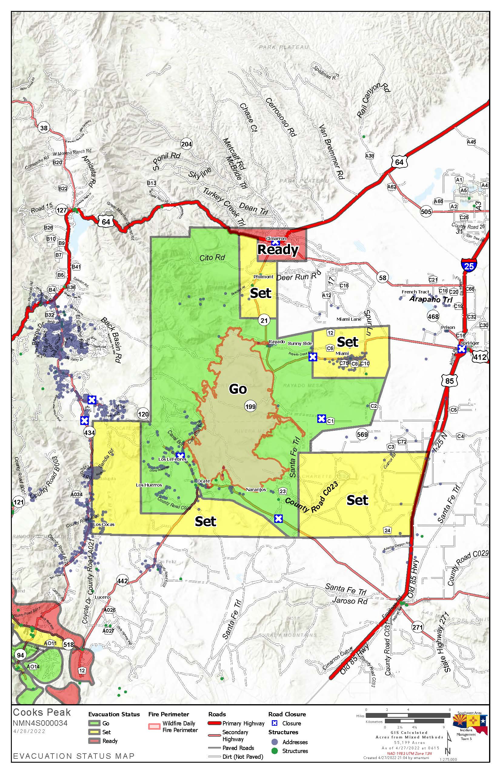
Current Evacuations for Cooks Peak Fire 1130 am 428222
Related Incident: Cooks Peak
Publication Type: Announcement
The map below provides a current evacuation status for the Cooks Peak Fire (as of 1130 am on April 28, 2022). The map is available in a .jpg and .pdf version.
Cooks Peak Fire Morning Update for April 28 2022
Related Incident: Cooks Peak
Publication Type: News
Firefighters continue building line to increase containment
Active fire behavior will continue as high winds return and temperatures increase
Acres: 55,886 acres
Location: North of Ocate NM, approximately 46 miles north of Las Vegas, NM
Containment: 34%
Start Date: Sunday, April 17, 2022
Cause: Human, under investigation
Fuels: ponderosa pine, oak brush and grass
Mora County – GO: Los LeFebres and Los Huerros, residents east of County Road 009 and north of NM Highway 120. Set: Los Cocas
The Mora and Colfax County Sheriff’s Offices are using the Ready! Set! Go! program for evacuation status that provides information on evacuation and evacuation preparation.
An Evacuation center is set up at Old Memorial Middle School, 947 Old National Rd, Las Vegas
Livestock: Residents can evacuate livestock to the Colfax County Fairgrounds. If residents from Mora need a place for horses, the Taos Rodeo Grounds is available. Contact: Livestock Inspector Ruben Baca 505-770-1490.
Fire Update:
YYesterday, favorable weather provided wildland crews an opportunity to improve firelines and increase containment on the Cooks Peak fire. Firefighters continued to build direct handline and dozer line in the Urraca Mesa area on the north and northwest portion of the fire where pinyon and juniper stands are holding pockets of heat. Firing operations and direct line were conducted in the southeast area along the Agueje Canyon to reduce pockets of unburned fuel and connect containment lines. Crews were able to tie in more containment line along the southern flank and are patrolling along the southwest edge along the Gallinas Mesa. Crews conducted firing operations in a 30-acre pocket of unburned fuel in the Halls Peak region and worked to increase handline and dozer line in the Duran Meadow area at the northwest edge in mixed conifer stands. Increased winds and some lightning disrupted fire operations during mid-day. Crews were able to resume work as the cells moved away from the area. No new starts were detected on Wednesday.
Today, ground crews and aerial resources will continue to improve firelines to secure firelines, increase containment, and check for hot spots. Crews will also begin to repair impacts from firefighting efforts where conditions permit. Wildland firefighting tactics will continue to vary with changing fuels, topography and weather.
Critical fire weather is expected through Friday. Strong, gusty, and erratic winds will impact firefighting operations and increase the burning potential of already dry fuels. The use of aerial resources will be based on wind conditions.
Weather: A Red Flag Warning has been issued for this afternoon – due to low relative humidity, strong gusty winds, and drought stressed fuels. On Friday, there will be a dangerous fire weather day with winds gusts up to 60 mph combined with warm temperatures and low relative humidity.
Highway Closures: New Mexico Highway 120 is closed from mile marker 26 to 3 miles west of Ocate. NM 21 is closed from mile marker 1, south of Cimarron to mile marker 18 west of Miami. Motorists are advised to delay travel or to seek alternate routes. Visit https://nmroads.com/mapIndex.html for additional information.
Fire Restrictions: New Mexico is in a drought. Even a small spark can start a wildfire. Fire restrictions are implemented to help reduce the chance of a wildfire. The New Mexico State Forester has implemented statewide fire restrictions. Smoking, fireworks, campfires open burning and open fires are prohibited. For more information see https://www.emnrd.nm.gov/sfd/forestry-news/ The Bureau of Land Management, Farmington District has also implemented fire restrictions. Fireworks, campfires, smoking and operating machinery, including off road OHV use are restricted. Visit Fire Restrictions | Bureau of Land Management (blm.gov) for details.
More Information:
Inciweb: https://inciweb.nwcg.gov/incident/8066/
New Mexico Fire information: https://nmfireinfo.com/
Smoke Outlook: https://outlooks.wildlandfiresmoke.net/outlook/b335b9f4
Facebook: https://www.facebook.com/CooksPeakFireInfo/
Evacuations: https://www.facebook.com/moracountysheriffoffice/
Information on Calf Canyon Fire:
Phone: 505-356-2636, phone answered from 8 a.m. to 8 p.m.
Inciweb: https://inciweb.nwcg.gov/incident/8069