
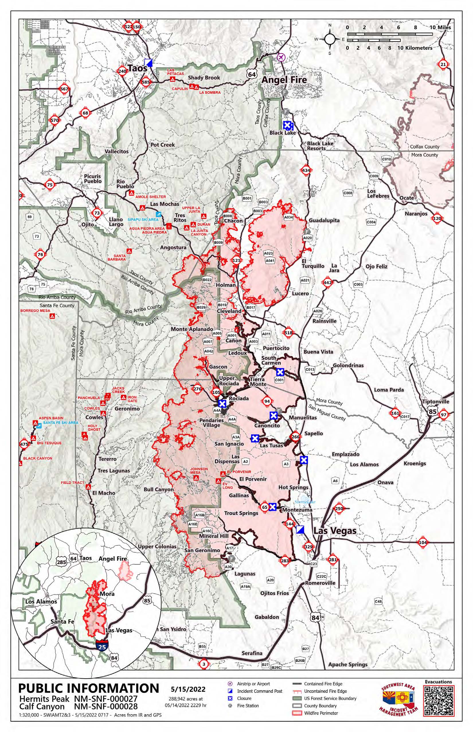
Hermits Peak and Calf Canyon Fires Daily Update 9 am May 15
Related Incident: Calf Canyon
Publication Type: News
Acres: 288,942 acres
Containment: 36%
Total personnel: 1,930
Start Date: Hermits Peak: April 6, 2022; Calf Canyon: April 19, 2022
Cause: Hermits Peak: Spot fires from prescribed burn; Calf Canyon: Under investigation
Location: Located near Gallinas Canyon
Fuels: Heavy mixed conifer, ponderosa pine, brush, and grass
Highlights: The Facebook page for official fire information has changed to www.facebook.com/CalfCanyonHermitsPeak. Please follow and reference this new page for video briefings, updates, photos, and live 6:00 PM community briefings. Today the Southwest Incident Management Team 3 (SWIMT3) assumed command of the lower half of the fire. The SWIMT 1 took management of the northern half, and the California IMT 2 will work to the north on a bigger-picture strategic plan for controlling this fire. The fire will remain active, with critically dry fuels and near-record temperatures. Both zones of the fire will continue to have heavy air support as conditions allow. Residents of San Miguel, Mora, Taos, and Colfax Counties should remain on high alert for changes to evacuation statuses and road closures.
Operations:
South: On the east perimeter, crews are monitoring and patrolling to address any issues. Interior fuel pockets continue to burn out but have not threatened any containment lines. Firefighters are addressing any remaining issues in the Mineral Hills and San Geronimo areas. The fire continues to burn below Barillas Peak on the southwest, and a dozer line to the Pecos Wilderness boundary is complete. Crews will try to fight the fire directly as it moves into an area they’ve identified as having a high probability of success. Aircraft will continue to be critical to these efforts. Structure protection groups remain in Bull Canyon, clearing fuels, setting up sprinkler systems, and enacting other protective measures. The fire continues to back slowly down into Bull Creek and Elk Creek into an old fire scar. Around Rociada and Gascon, the fire is moving away from homes, and structure protection groups remain in place. The fire continues to push into the wilderness in areas on the west side.
Central (SWIMT1): The fire was active yesterday from the Angostura Trail to Serpentine Lake. Structure protection work continues in the Angostura community. The fire continues to move around Chacon, Holman, Cleveland, and Mora, but crews are working to keep it away from structures and putting in additional firelines. Near Guadalupita and Sierra Bonita, firefighters, dozers, and helicopters are trying to keep the fire at higher elevations to minimize impacts to these communities. Structure protection groups have a heavy presence in Highway 518, 121, 434, and 442 corridors, around Black Lake and up to Angel Fire. Fire managers are coordinating with local and mutual aid firefighters around Black Lake in these efforts.
North (CIMT2): In the north zone, planning is underway to look at additional locations where containment line may be constructed. This does not mean the fire will get to this area, but we are taking the opportunity to be proactive and prepared in advance of any threat.
Evacuations:
An evacuation map is available online. Or you can follow:
San Miguel County Sheriff’s Office Facebook
Mora County Sheriff’s Office Facebook
Taos County Sheriff’s Office Facebook
Weather: West to southwest winds 15 to 20 mph, gusts to 25 on the north and central zones. Temperatures today range from the upper 60’s to mid-80’s depending on elevation. Minimum relative humidity 7 to 11%.
Restrictions: Carson National Forest Camino Real Ranger District closure order and map. Santa Fe National Forest Pecos/Las Vegas Ranger District closure order and map. Both have forest-wide Stage 2 fire restrictions in place.
Smoke: An interactive smoke map allows you to zoom into your area to see the latest smoke conditions.
Fire Information: Fire Information Office Hours: 8:00 AM – 8:00 PM | Phone: 505-356-2636 | Email: 2022.hermitspeak@firenet.govOnline at Inciweb| facebook.com/CalfCanyonHermitsPeak | nmfireinfo.com/
San Miguel and Mora County Daily Information Update
Related Incident: Calf Canyon
Publication Type: News
San Miguel and Mora County News Release
Las Vegas – Today, the incoming Type 1 Southwest Incident Management Team 1 (SWIMT 1) and Type 1 California Team 2 are shadowing the current teams to ensure a seamless transition Sunday. Active fire behavior is predicted today with critically dry relative humidity and higher temperatures; however, with less wind, the fire isn't expected to grow significantly. Yesterday, every aircraft assigned to the incident was over the fire throughout the day. With similar conditions today, helicopters and fixed-wing aircraft will be up again to support the firefighters on the ground. Residents of San Miguel, Mora, Taos, and Colfax counties should remain on high alert for changes to evacuation statuses and road closures.
Please be advised that drones are prohibited in the temporary flight restriction zone which is outlined on the map. If drones enter the flight zone, firefighting aircraft are grounded.
Fire Personnel in Mora County - Please do not utilize the hydrants for filling apparatus. Fill with non-potable water.
Restrictions: The Santa Fe National Forest has expanded the closure order due to the fire to include the entire Pecos/Las Vegas Ranger District and has implemented forest-wide Stage 2 fire restrictions. Full closure order and map are available.
County Fire Restrictions: All open burning (burning of crop land, fields, range land, debris, burning slash piles, prescribed burning or weed burning) in San Miguel County, shall be banned throughout the unincorporated areas of the County, and the provisions of SMC Ordinance 03-9-99ORD are in effect. This ban shall prohibit any person from having, causing, starting, igniting and/or using open flame outside of a building, structure, automobile, or other enclosed area anywhere, throughout the unincorporated portions of San Miguel County.
Weather: On the southern end, west to southwest winds 15 to 20 mph, gusts to 27. On the northern end, north to northwest winds 10 to 15 mph, gusts to 28. Maximum temperatures upper 60’s to mid-80’s. Minimum relative humidity 5 to 13%.
Smoke: An interactive smoke map allows you to zoom into your area to see the latest smoke conditions
Power Outages: Power has been shut down in some evacuated areas. Lines will be re-energized when conditions are safe for fire personnel and law enforcement. Power has been restored to the community of Mora, for the purpose of water distribution, by authorization of the Incident Management Team.
LIVESTOCK OWNERS: If you have livestock within the evacuation zone, contact NM State Police Dispatch at 505-425-6771 to coordinate a safe escort to your property to feed your animals. Do not enter the evacuation area un-escorted.
Federal Disaster Assistance: Visit disasterassistance.gov. To make it easier to communicate with FEMA create an online account. You can upload documents and check the status of your application from anywhere with an internet connection. You can also Call the FEMA Helpline at 800-621-3362. Lines are open from 7 a.m. to 11 p.m. MDT, seven days a week. If you use a relay service, such as a videophone (VRS), captioned telephone service or others, give FEMA the number for that service.
Future Fire Information: The Hermits Peak and Calf Canyon Fires Information office hours are 8:00 AM –8:00 PM. The phone number for fire information is 505-356-2636. The email address is 2022.calfcanyon@firenet.gov. Future fire information will continue to be posted on Inciweb, the SFNF Facebook and Twitter, SFNF website, and New Mexico Fire Information website.
Fire Resource Hotline: 1-800-432-2080: The following phone number will provide residents impacted by the Calf Canyon/ Hermits Peak Fire with fire consequence resources or sheltering needs.
To sign up for RAVE alerts. Text SMCNOTIFY to 67283.
Updates will be posted on San Miguel County OEM, San Miguel’s County Sheriff’s, Mora County Sheriff’s, and Fire Department Facebook pages.
Contact: Travis Martinez, PIO | Travis.Martinez@state.nm.us | 505 617-5900
Road Closure Update for Calf Canyon Hermits Peak Fire
Related Incident: Calf Canyon
Publication Type: Closures
New Mexico Department of Transportation News Release
LAS VEGAS – The following road closures are still in place. Please be advised that these routes are open for evacuation only, no reentry is allowed.
- N.M. 518 is closed between mile markers 26 (La Cueva) to 52 (Sipapu)
- N.M. 518 is restricted from CR A011 due to wildfire
- N.M. 94 is closed at mile post 17.5- N.M. 434 is closed between mile markers 0 (Mora) to 32 (2 miles south of Angel Fire)
- N.M. 442 is closed at mile post 0 (Jct. of N.M. 442 and N.M. 518) to mile post 21 (Ocate)
- N.M. 121 is closed between mile markers 0 (jct. at 518) to 8- N.M. 120 at mile post 17.2 (Jct. of N.M. 120 & N.M. 442) is closed.
- N.M. 276 is closed between mile markers 0 to 5 (Maestas)- N.M. 65 is closed at mile post 15 (El Porvenir)
- N.M. 283 is closed between mile markers 1 (Detention Center) to 13 (Mineral Hill)
- N.M. 105 is closed at mile post 3 (Transfer station)- County Road A4A is being restricted at the junction of CR A4A and A34
Contact
Travis Martinez, District-4 PIO | Travis.Martinez@state.nm.us | 505 617-5900
Hermits Peak and Calf Canyon Fires Daily Update 830 am May 14
Related Incident: Calf Canyon
Publication Type: News
Acres: 279,868 acres
Containment: 27%
Total personnel: 1,924
Start Date: Hermits Peak: April 6, 2022; Calf Canyon: April 19, 2022
Cause: Hermits Peak: spot fires from prescribed burn; Calf Canyon: under investigation
Location: Located near Gallinas Canyon - Fuels: Heavy mixed conifer, ponderosa pine, brush, and grass
Highlights: Today, the incoming Type 1 Southwest Incident Management Team 1 (SWIMT 1) and Type 1 California Team 2 are shadowing the current teams to ensure a seamless transition Sunday. Active fire behavior is predicted today with critically dry relative humidity and higher temperatures; however, with less wind, the fire isn't expected to grow significantly. Yesterday, every aircraft assigned to the incident was over the fire throughout the day. With similar conditions today, helicopters and fixed-wing aircraft will be up again to support the firefighters on the ground. Residents of San Miguel, Mora, Taos, and Colfax counties should remain on high alert for changes to evacuation statuses and road closures.
Operations: On the north, structure protection crews are working around Angostura to prepare homes and values as fire pushes toward the Angostura Trail today. Firefighters are working in the areas of Chacon, Holman, Cleveland, and Mora along the fire's edge to mitigate impacts. Yesterday, the fire stayed out of the Chacon valley as it moved north. Above Mora, crews are constructing additional dozer lines as the fire backs down Comanche Canyon. Firefighters continue to work in the Highway 518, 121, 434, and 442 corridors up to and around Black Lake. Today, the fire is predicted to end up near Guadalupita South, and structure protection groups are doing lots of work there. Crews worked west from the Cooks Peak Fire and east from the Hermits Peak and Calf Canyon fire to open dozer lines and connect roads, meeting in the middle. Towards Highway 442, crews are finishing tying in line with Martinez Ranch Road.
On the south, crews are monitoring around Mineral Hills and San Geronimo to make sure nothing else is threatened. The fire remains active around Barillas Peak. Large and Very Large Air tankers (LATs and VLATs) were able to drop retardant on that line yesterday to assist ground crews. Firefighters are working directly on this edge, and additional lines are being constructed to the south. Crews are also creating a dozer line to the wilderness boundary above Bull Canyon and connecting some roads and trails. The fire has crossed the crest at Elk Mountain and is moving slowly into an old fire scar. There will be a lot of smoke coming from this area. Around Rociada and Gascon, firefighters are still working to secure the fire's edge. The fire continues to move into the Pecos Wilderness in areas along the northwestern side.
Evacuations: An interactive map collection is available, including the evacuation map. Follow Taos County, San Miguel County, and Mora County Sheriff’s Office Facebook pages for the latest updates.
Weather: On the southern end, west to southwest winds 15 to 20 mph, gusts to 27. On the northern end, north to northwest winds 10 to 15 mph, gusts to 28. Maximum temperatures upper 60’s to mid-80’s. Minimum relative humidity 5 to 13%.
Restrictions: A new Carson National Forest closure order includes the entire Camino Real Ranger District. Forest-wide Stage 2 fire restrictions have been implemented. Full closure order and map. The Santa Fe National Forest closure order includes the entire Pecos/Las Vegas Ranger District. Forest-wide Stage 2 fire restrictions have been implemented. Full closure order and map.
Smoke: An interactive smoke map at https://fire.airnow.gov/ allows you to zoom into your area to see the latest smoke conditions.
Fire Information: Fire Information Office Hours: 8:00 AM – 8:00 PM | Phone: 505-356-2636 | Email: 2022.hermitspeak@fire.gov | Inciweb | SFNF Facebook | Twitter | SFNF website | New Mexico Fire Information website
FEMA in Your Community
Related Incident: Calf Canyon
Publication Type: News
News Release from San Miguel and Mora County
LAS VEGAS – Disaster Survivor Assistance (DSA) teams and damage assessment inspectors from FEMA are out in New Mexico communities to help residents get connected with potential assistance.
New Mexico homeowners and renters in Colfax, Lincoln, Mora, San Miguel, and Valencia counties, who sustained damage from wildfires and straight-line winds beginning on April 5 and continuing, could be eligible for help from FEMA.
If you have homeowners or renters insurance, you should file a claim as soon as possible. By law, FEMA cannot duplicate benefits for losses covered by insurance. If your policy does not cover all your damage expenses, you may then be eligible for federal assistance.
Once residents have completed their application, they should expect a call from an inspector to set up a damage assessment. The phone number may not be a recognized number. Damage assessments occur once residents apply with FEMA. They are an essential part of the recovery process for those who need to make their homes livable again or have serious personal property loss. Homeowners and renters should make sure their contact information is up to date and have access to a telephone. They will need to have a photo ID and proof of ownership or a lease.
Disaster Survivor Assistance Teams will be moving through affected areas to answer questions about the types of help available, help residents apply for state and federal assistance, update an applicant’s contact information and help with referrals to whole community partners.
DSA team members wear FEMA shirts and/or vests as well as carry photo identification. Residents should ask to see them. They are currently setup at the Old Memorial Middle School on 947 Old National in Las Vegas.
While residents in all five affected counties can apply for disaster assistance, damage assessments can only be conducted in areas where wildfires are not ongoing. Lincoln and Valencia are currently the only counties not experiencing active fires.
The fastest and easiest way to apply is by visiting disasterassistance.gov/.
If it is not possible to apply online, call 800-621-3362. The toll-free telephone line operates from 7 a.m. to 10 p.m. MDT seven days a week. If you use a relay service, such as video relay service (VRS), captioned telephone service or others, give FEMA the number for that service.
Contact
Travis Martinez, PIO | Travis.Martinex@state.nm.us | 505 617-5900
State providing drinking water for communities affected by wildfires
Related Incident: Calf Canyon
Publication Type: News
News Release from the State of New Mexico Department of Homeland Security and Emergency Management
Drinking water available for customers of systems under precautionary water advisory.
SANTA FE – Beginning today, the state will deliver drinking water to individuals living in areas where evacuation orders have been lifted and are served by water systems under a temporary precautionary water advisory.
Residents needing free, safe drinking water may bring clean, empty containers to the following locations for fill-up:
- San Miguel County: 9-11 a.m. at Mike Mateo Sena Elementary School, 12 County Road A-1, Sapello, NM 87745
- Mora County: 1-3 p.m. at Mora County Courthouse Parking Lot, 1 Court House Dr, Mora, NM 87732
Until individual systems ensure water is safe to drink, residents are advised to use alternate sources of water.
More information about specific communities included in the full news release.
Contact
Marisa Maez, Communications Director | Marisa.Maez@state.nm.us | 505 469 8243
Hermits Peak and Calf Canyon Fires Daily Update 9 am May 13
Related Incident: Calf Canyon
Publication Type: News
Acres: 270,447 acres
Containment: 29%
Total personnel: 1,832
Start Date: Hermits Peak: April 6, 2022; Calf Canyon: April 19, 2022
Cause: Hermits Peak: spot fires from prescribed burn; Calf Canyon: under investigation
Location: Located near Gallinas Canyon
Fuels: Heavy mixed conifer, ponderosa pine, brush, and grass
Highlights: Due to this fire's increasing size and complexity, beginning Sunday management will be split into a North and South Zone. The Type 1 Southwest Incident Management Team 1 (SWIMT 1) is returning and will take management of the North Zone. SWIMT 3, currently working with SWIMT 2, will manage the South Zone. SWIMT 2 will transition out after Saturday. An additional Type 1 team from California will begin working further north on a bigger-picture strategy for controlling this fire. These changes will not affect communication to the public; expect to find your information in the same places. The weather is slightly improved with a Fire Weather Watch rather than a Red Flag Warning. However, the relative humidity is critically low, causing continued active fire behavior. Expect to see large smoke columns today. Aircraft flew yesterday and will be up again today as visibility allows. Residents of San Miguel, Mora, Taos, and Colfax counties should remain on high alert for changes to evacuation statuses and road closures.
Operations: Fire is pushing toward Angostura, and structure protection crews are working to prepare homes and values in the area. Yesterday west winds near Chacon allowed firefighters to construct more fireline around the community. The fire is following the timber fuel and could push across Highway 121 north of Chacon today. Local firefighting resources in Colfax County are coordinating with fire leadership, and structure protection crews are in Highway 518, 121, 434, and 442 corridors up to and around Black Lake. Firefighters, heavy equipment, and helicopters continue to fight spot fires across 434. Fire could end up near Coyote State Park today. The east side from Ledoux to Las Vegas is in patrol status. On the south, near Mineral Hills and San Geronimo, crews have been able to secure the lines and are monitoring and patrolling. Some resources have been moved from this area to other parts of the fire. Yesterday the fire crossed a piece of fireline in the southwest area around Barillas Peak. Large Air Tankers put down retardant to help the firefighters on the ground get a line around it, but night crews had to reevaluate strategy when the diurnal winds shifted. They will continue working on it today. People in Pecos can expect to see more activity at night due to the terrain and night breezes. There has been more activity around Elk Mountain to Gascon as the fire is trying to push upslope into the wind. Crews have been working hard in this area, protecting structures, conducting defensive firing operations, and securing the fire's edge. The fire is still moving into the Pecos Wilderness towards Lone Pine Mesa, Blue Bell Ridge, and further north near Enchantment Lake.
Evacuations: See an interactive map collection, including the evacuation map. Follow Taos County, San Miguel County, and Mora County Sheriff’s Office Facebook pages for the latest updates.
Weather: On the southern end, southwest winds 15 to 20 mph with gusts to 30. In the Mora River Valley, north to northwest winds 10 to 15 mph with gusts to 25. Maximum temperatures upper 60’s to upper 70’s. Minimum relative humidity 3 to 11%.On the southern end, southwest winds 15 to 20 mph with gusts to 30. In the Mora River Valley, north to northwest winds 10 to 15 mph with gusts to 25. Maximum temperatures upper 60’s to upper 70’s. Minimum relative humidity 3 to 11%.
Restrictions: A new Carson National Forest closure order includes the entire Camino Real Ranger District. Forest-wide Stage 2 fire restrictions have been implemented. Full closure order and map.
The Santa Fe National Forest closure order includes the entire Pecos/Las Vegas Ranger District. Forest-wide Stage 2 fire restrictions have been implemented. Full closure order and map.Smoke: An interactive smoke map allows you to zoom into your area to see the latest smoke conditions.
Road Closure Update for Calf Canyon Hermits Peak Fire 0513
Related Incident: Calf Canyon
Publication Type: Closures
New Mexico Department of Transportation News Release
LAS VEGAS – The following road closures are still in place. Please be advised that these routes are open for evacuation only, no reentry is allowed.
- N.M. 518 is closed between mile markers 26 (Mora County Line) to 52 (Toas County)
- N.M. 518 is restricted from CR A011 due to wildfire
- N.M. 434 is closed between mile markers 0 (Mora) to 32 (2 miles south of Angel Fire)
- N.M. 442 is closed at mile post 0 (Jct. of N.M. 442 and N.M. 518) to mile post 19 (Ocate)
- N.M. 121 is closed between mile markers 0 (jct. at 518) to 8
- N.M. 105 is closed between mile markers 3 (Lower Rociada) to 9 (Gascon)
- N.M. 276 is closed between mile markers 0 to 5 (Maestas)
- N.M. 65 is closed at 00mile post 15 (El Porvenir)
- N.M. 283 is closed between mile markers 1 (Detention Center) to 13 (Mineral Hill)- County Road A4A is being restricted at the junction of CR A4A and A34
Travis Martinez, District-4 PIO Travis.Martinez@state.nm.us | 505-617-5900
San Miguel and Mora County Evacuation Updates 445 pm May 12
Related Incident: Calf Canyon
Publication Type: Closures
News Release from San Miguel and Mora County
LAS VEGAS -The following communities of Camp Luna and NMBHI have been downgraded to READY STATUS. Canovas Canyon, Trout Springs, Gallinas, Lower Canyon Road, El Porvenir, Porvenir Canyon, and Big Pine are still in SET STATUS. The communities of Rociada, Upper Rociada, Mineral Hill, San Pablo, San Geronimo, and Ojitos Frios are still under GO STATUS. Please continue to stay informed by following local media, local fire alerts, and county emergency notifications.
ROAD CLOSURES
San Miguel County
N.M. 518 is closed between mile posts 26 (La Cueva) and 52 (Sipapu). N.M. 94 is closed at mile post 18 (Restricting access to Mora). N.M. 105 is closed at mile post 4. N.M. 276 is closed at mile post 0, N.M. 283 is closed between mile posts 1 (San Miguel Detention Center) and 15. N.M. 65 will be closed at mile post 15.
Mora County
N.M. 518 is closed between mile posts 26 (La Cueva) and 52 (Sipapu). N.M. 94 is closed at mile post 18 (Restricting access to Mora). N.M. 442 is closed at mile post 19 (Ocate). N.M. 434 is closed at mile post 26 (Black Lake). N.M. 121 is closed between mile posts 0 and 8.
Hermits Peak and Calf Canyon Fires Daily Update 9 am May 12
Related Incident: Calf Canyon
Publication Type: News
Acres: 259,810 acres - Containment: 29% - Total personnel: 1,859
Start Date: Hermits Peak: April 6, 2022; Calf Canyon: April 19, 2022
Cause: Hermits Peak: spot fires from prescribed burn; Calf Canyon: under investigation
Location: Located near Gallinas Canyon - Fuels: Heavy mixed conifer, ponderosa pine, brush, and grass
Highlights: This fire is going to keep growing, and more firefighters, heavy equipment operators, support crews, and incident command teams are being ordered. The weather has been unfavorable for weeks, and another Red Flag Warning is in place from 9:00 AM to 8:00 PM. This will continue to cause extreme fire behavior and rapid growth, especially to the north. Much of the fire's growth is in thick, heavy timber and steep, rugged terrain. Spotting distances could be as far as ½ to ¾ of a mile today. Structure protection crews are moving into new communities likely to be impacted. Yesterday aircraft flew throughout the day. However, they were grounded at times on the south due to winds and on the north due to poor visibility. They plan to be active today as conditions allow. The Temporary Flight Restriction is now 70 miles long and applies to all drones and aircraft not working the fire. Residents of San Miguel, Mora, Taos, and Colfax counties should remain on high alert for changes to evacuation statuses and road closures.
Operations: With lots of fire over Highway 518 and spreading rapidly, day and night crews are conducting defensive firing operations to reduce fuels ahead of the fire and around homes. Structure protection groups comprised of hand crews, dozers, and engines are still working in the Highway 518, 121, 434, 442 corridors and canyon communities. They are moving further north into communities up to Black Lake and west around Angostura. Fire leadership is working with landowners around Black Lake to scout and locate features like roads to tie lines together and formulate a plan with the highest probability of success. The east side from Ledoux to Las Vegas looks good. Some visible interior pockets of fuel continue to burn out but pose no threat to containment lines. On the south, firelines have held, and the winds are pushing the fire back into itself. Structure protection groups are still working in the area. On the southwest, the fire is backing into the wind, resulting in low rates of spread. More firefighters have been moved to work around Barillas Peak. On the Pecos side, crews are constructing firelines, fighting fire direct where possible, and getting familiar with the terrain and values at risk for developing other strategies. Structure protection crews are working in Upper and Lower Colonias and Bull Canyon if the fire moves in those directions. Around Rociada, firefighters battled fire in an area that flared up yesterday. Crews continue protecting structures, conducting defensive firing operations, and securing the fire's edge in that area. The fire is still moving into the Pecos Wilderness towards Lone Pine Mesa, Blue Bell Ridge, and further north near Enchantment Lake.
Evacuations: View an interactive map collection, including the evacuation map. Follow Taos County, San Miguel County, and Mora County Sheriff’s Office Facebook pages for the latest updates.
Weather: On the southern end, winds west to southwest 28 to 32 mph with gusts to 45. In the Mora River Valley, west winds 15 to 20 mph with gusts to 30. Maximum temperatures lower 60’s to mid-70’s. Minimum relative humidity 5 to 14%.
Restrictions: A new Carson National Forest closure order includes the entire Camino Real Ranger District. Forest-wide Stage 2 fire restrictions have been implemented. Full closure order and map. The Santa Fe National Forest closure order includes the entire Pecos/Las Vegas Ranger District. Forest-wide Stage 2 fire restrictions have been implemented. Full closure order and map.
Smoke: An interactive smoke map allows you to zoom into your area to see the latest smoke conditions.
Fire Information: The Hermits Peak and Calf Canyon Fires Information office hours are 8:00 AM – 8:00 PM. The phone number for fire information is 505-356-2636. The email address is 2022.hermitspeak@firenet.gov. Official fire information is posted on Inciweb the SFNF Facebook and Twitter, SFNF website, and New Mexico Fire Information website.