U.S. flag

An official website of the United States government

Here's how you know

San MiguelMora County News Release Calf Canyon Fire Evacuations

Related Incident: Calf Canyon
Publication Type: Closures

 May be an image of text
No photo description available.


San Miguel Mora County News Release Calf Canyon Current Fire Evacuations

Related Incident: Calf Canyon
Publication Type: Closures

San Miguel /Mora County News Release

Calf Canyon Current Fire Evacuations

April 29, 2022 at 4:30 PM


     Media Contacts:       Joy Ansley    505-239-3973, jansley@co.sanmiguel.nm.us  

            Jesus Romero    505-617-8023, jmromero@co.sanmiguel.nm.us

Las Vegas, NM 4:30 pm

High winds from different directions are pushing the fire into new areas. Please read carefully, as evacuation status’ are changing.

Community Evacuation Status in San Miguel and Mora Counties:

GO (mandatory full evacuation, colored green): In San Miguel County, Big Pine, Canovas Canyon, Porvenir Canyon, El Porvenir, Lower Canyon Road, Gallinas and Trout Springs are still in Go status and residents are being urged to leave these areas now. Also in Go are the area on the map identified as Hot Springs, Storrie Lake, Las Dispensas, San Ignacio, Lone Pine Mesa, Chavez, Canoncito, Pendaries Village, Pendaries Valley East, Rociada, Upper Rociada and Tierra Monte Canon, La Canada, Las Tusas, the area of 527-525 on Highway 518 and Manuelitas.

In Mora County, Penasco Blanco, South Carmen, Ledoux, Upper Morphy, Santiago Creek, Abuelo and Puertocito are all still in Go status.

SET (prepare for evacuation, colored yellow): In San Miguel County, East and West Sapello and Emplazado have been added to set status.  

In Mora County, South Mora is currently in SET status.

READY (get ready for possible evacuation, colored red): No areas are currently in READY status in San Miguel County.

In Mora County, North Mora, Buena Vista and Rito Cebolla are currently in Ready status.

The evacuation map is attached. This emerging situation remains extremely serious and refusal to evacuate could be a fatal decision. 

Road Closures:

In San Miguel County, State Road 65 at the post office, and CR A27 are closed.  Eighth Street Extension at CR A14A (Pork Chop Hill Road) is closed. CR A11A, from Eighth Street Extension to Hwy 65 is closed. State Roads 105, 94, 266 and 276 remain closed. Hwy 518 from Hwy 161 to Storrie Lake is closed.

Road closures in Mora County include C001, State Road 94 at LeDoux Hill. County Road A011 is closed south from the roadblock approximately 1.5 miles from 518.

Please remember that drones are still prohibited in the temporary flight restriction zone, outlined on the map. If drones enter the flight zone, firefighting aircraft are grounded.


Power Outages: Power has been shut down in some evacuated areas. Lines will be re-energized when conditions are safe for fire personnel and law enforcement.

LIVESTOCK OWNERS: If you have livestock within the evacuation zone, contact NM State Police Dispatch at 505-425-6771 to coordinate a safe escort to your property to feed your animals. Do not enter the evacuation area un-escorted.

Property Losses: To complete the Calf Canyon and Hermits Peak Property Damage Survey, fill out the online form:  https://forms.gle/f4fGE28AEGzZbbBKA. For help with the survey please call 505-425-9333. You can also find information on the San Miguel County Website https://co.sanmiguel.nm.us/.

County Fire Restrictions: All open burning (burning of crop land, fields, range land, debris, burning slash piles, prescribed burning or weed burning) in San Miguel County, shall be banned throughout the unincorporated areas of the County, and the provisions of SMC Ordinance 03-9-99ORD are in effect.  This ban shall prohibit any person from having, causing, starting, igniting and/or using open flame outside of a building, structure, automobile or other enclosed area anywhere, throughout the unincorporated portions of San Miguel County.

Shelter sites:

         San Miguel County: Old Memorial Middle School gym, Legion St. Las Vegas, 505-429-0336

         Mora County: Penasco High School gym, 13 Old School Road- Melissa Sandoval- 575-779-3057  

                                 Taos Youth and Family Center 407 Paseo del Canon

Shelter site for horses and livestock: The Zamora arena continues to be utilized to temporarily house evacuated horses and livestock.  The contact for livestock and horses is Matthew Romero, Livestock Inspector, 575-643-6805.

Link to Ready, Set Go, Wildland Fire Action Guide:

https://cms6.revize.com/revize/sanmiguelcounty/FINAL-new-mexico-RSG-guide-2017_000.pdf

Updates will be posted on San Miguel County OEM, Sheriff and Fire Facebook pages.


Calf Canyon and Hermits Peak Fires Daily Update 9 am April 29

Related Incident: Calf Canyon
Publication Type: News
Calf Canyon and Hermit’s Peak Fires

April 29, 2022, Daily Update, 09:00AM


Acres:  65,824 acresContainment: 37% Start Date:  April 19, 2022Cause: Under investigationTotal personnel: 965 Location: Located near Gallinas CanyonFuels: Mixed conifer Highlights: A wind-driven run on the north edge of the fire challenged firefighters on the ground and in the air yesterday. Structure protection measures continue to be a top priority across the fire area. Power has been restored to some areas of the fire but others cannot be re-energized until it is safe to do so. Evacuation and road closure status may change rapidly today, please watch for updates. Respect all closures and allow firefighting resources to work safely. Firefighter and public safety will continue to be the number one priority.Operations: Containment lines on the northern edge of the fire were challenged yesterday by strong winds and rising temperatures. A wind-driven run pushed over established lines in the Capulin Mountain area, creating a smoke column visible for a great distance. Firefighters worked overnight to slow spread towards the community of Ledoux. Higher winds are predicted for today, with a red flag warning beginning at 9 AM and a high wind warning from Albuquerque National Weather Service. These weather conditions pose a high risk to firefighters and may require resources to disengage, relocate, or change tactics for safety. An additional structure group was formed, making three total groups that are assigned to the north, west and south areas of the fire. These groups will work today to implement protection measures and perform point protection around homes, outbuildings, and other features. Air operations will be limited in their work by high winds.Evacuations: The San Miguel and Mora County Sheriffs ask that all residents within the fire area remain on high alert for changes to evacuation statuses and road closures. Red Flag weather today could result in sudden changes to closures and evacuation levels. It is imperative to respect closures and follow evacuation orders. Failure to do so can pose additional risk to firefighters and the public. Please follow San Miguel County and Mora County Sheriff’s Facebook pages for the latest updates at https://www.facebook.com/smcso.nm and https://www.facebook.com/moracountysheriffoffice. Weather: A red flag warning is in place beginning today at 9:00 AM until 9:00 PM, as well as a high wind warning from Albuquerque National Weather Service. Sustained winds of 30-35 MPH are expected, with gusts up to 50 MPH, increasing with elevation and maintaining throughout the shift. Poor relative humidity recovery overnight combined with rising temperatures and high winds will challenge established fire lines and hamper firefighting efforts in the air and on the ground.Restrictions: The Santa Fe National Forest has issued a closure order and has implemented Stage II fire restrictions to protect public health and safety during fire operations on the Calf Canyon Fire. Full closure order and map are available at https://www.fs.usda.gov/main/santafe/home. The temporary flight restriction (TFR) in place over the area was expanded to include the Gallinas Canyon area. The TFR also covers unmanned aircraft, or drones. If a private drone intrudes into the fire area, it will require a pause in all air operations and impede firefighting progress, putting firefighters at greater risk.Smoke: Las Vegas area will see moderate smoke in the area today with periods of Unhealthy for Sensitive Groups (USG) when the winds increase out of the west early this morning switching to west-northwest in the afternoon. Mora and surrounding areas will see good to moderate air quality today with west winds. East Mora area to La Cueva will see heavy smoke at periods of the day. Rociada, Pendaries, Buena Vista, and Sapello will see unhealthy air quality conditions today as fire activity and winds increase. An interactive smoke map at https://fire.airnow.gov/ allows you to zoom into your area to see the latest smoke conditions.Future Fire Information: The Calf Canyon Fire and Hermit Peak Fire Information office hours are 8:00 AM – 8:00 PM.  The phone number for fire information is 505-356-2636. The email address is 2022.calfcanyon@firenet.gov. Future fire information will continue to be posted on Inciweb, the SFNF Facebook and Twitter, SFNF website, and New Mexico Fire Information website

San Miguel Mora County News Release April 28

Related Incident: Calf Canyon
Publication Type: News

San Miguel /Mora County News Release

Calf Canyon Current Fire Evacuations

April 28, 2022 at 3:00 PM


     Media Contacts:       Joy Ansley    505-239-3973, jansley@co.sanmiguel.nm.us  

            Jesus Romero    505-617-8023, jmromero@co.sanmiguel.nm.us

Las Vegas, NM 3:00 pm: The San Miguel and Mora County Sheriffs ask that all residents within the Calf Canyon/Hermits Peak Fire areas remain on high alert for changes to the following evacuation statuses. Red Flag weather this afternoon and tomorrow could result in sudden changes to closures and evacuation levels. Please watch for updates on social media or call the fire information line at 505-356-2636 to get the most up-to-date information.

It is imperative to respect closures and follow evacuation orders. Failure to do so can pose additional risk to firefighters and the public.

Highway 518 is now open. Please drive carefully and be aware of fire traffic in the area.

Community Evacuation Status in San Miguel and Mora Counties:

GO (mandatory full evacuation, colored green): In San Miguel County, Big Pine, Canovas Canyon, Porvenir Canyon, El Porvenir, Lower Canyon Road, Gallinas, Trout Springs, San Ignacio, Lone Pine Mesa, Chavez, Canoncito, Pendaries Village, Pendaries Valley East, Rociada, Upper Rociada and Tierra Monte Canon, La Canada, Las Tusas, and Manuelitas are all still in GO status. 

In Mora County, Penasco Blanco, South Carmen, Rito Cebolla, Ledoux, Upper Morphy, Santiago Creek, Abuelo, Puertocito and Buena Vista are all still in GO status.

SET (prepare for evacuation, colored yellow): The community of Mora SOUTH of Highway 518 is in ready status approximately 1.5 miles south to roadblocks on A001, A011 and 94. The area south of these roadblocks is in GO status.

READY (get ready for possible evacuation, colored red):

In San Miguel, the area of 527-525 on Highway 518 as well as East and West Sapello are in READY status.

In Mora County, Rito Cebolla, Buena Vista, and the community of Mora NORTH of Highway 518 are all in READY status.

The areas of Las Dispensas, County Road A3 and Los Alamitos are no longer under evacuation.

San Miguel & Mora County Sheriff’s Departments and local law enforcement, along with the Incident Management Team will continue to perform re-assessments of these evacuation levels as the fire progresses. As we continue to work, please stay vigilant and adhere to instructions from press releases, law enforcement and fire personnel. The evacuation map is attached. This emerging situation remains extremely serious and refusal to evacuate could be a fatal decision. 

Please remember that drones are still prohibited in the temporary flight restriction zone, outlined on the map. The evacuation/flight zone map is attached. If drones enter the flight zone, firefighting aircraft are grounded.

Road Closures: In San Miguel County, State Road 65 at the Montezuma Pond, and CR A27 are closed.  County Road A3A and CR A4A are closed and State Roads 105, 94, 266 and 276 remain closed. Highway 518 is now open. County Road A3 is open to State Road 266.

Road closures in Mora County include C001, State Road 94 at LeDoux Hill. County Road A011 is closed south from the roadblock approximately 1.5 miles from 518.

Lake Isabel is closed to the public.

Power Outages: Power has been shut down in some evacuated areas. Lines will be re-energized when conditions are safe for fire personnel and law enforcement.

LIVESTOCK OWNERS: If you have livestock within the evacuation zone, contact NM State Police Dispatch at 505-425-6771 to coordinate a safe escort to your property to feed your animals. Do not enter the evacuation area un-escorted.

Property Losses: Damage and loss assessments are still underway. Notifications will be made to residents as soon as possible. We know this process is difficult for so many members of our community, and we are grateful for your patience.

County Fire Restrictions: All open burning (burning of crop land, fields, range land, debris, burning slash piles, prescribed burning or weed burning) in San Miguel County, shall be banned throughout the unincorporated areas of the County, and the provisions of SMC Ordinance 03-9-99ORD are in effect.  This ban shall prohibit any person from having, causing, starting, igniting and/or using open flame outside of a building, structure, automobile or other enclosed area anywhere, throughout the unincorporated portions of San Miguel County.

Shelter sites:

         San Miguel County: Old Memorial Middle School gym, Legion St. Las Vegas, 505-429-0336

         Mora County: Penasco High School gym, 13 Old School Road- Melissa Sandoval- 575-779-3057  

                     Taos County Agricultural Center- 202 Chamisa Rd., Can accept small household pets

                     Taos Youth and Family Center 407 Paseo del Canon

Shelter site for horses and livestock: The Zamora arena continues to be utilized to temporarily house evacuated horses and livestock.  The contact for livestock and horses is Matthew Romero, Livestock Inspector, 575-643-6805.

Link to Ready, Set Go, Wildland Fire Action Guide:

https://cms6.revize.com/revize/sanmiguelcounty/FINAL-new-mexico-RSG-guide-2017_000.pdf

Updates will be posted on San Miguel County OEM, Sheriff and Fire Facebook pages.


Calf Canyon and Hermits Peak Fires Daily Update 9 am April 28

Related Incident: Calf Canyon
Publication Type: News

 Calf Canyon and Hermit’s Peak Fires

April 28, 2022, Daily Update, 09:00AM


Acres:  63,720 acresContainment: 33% Start Date:  April 19, 2022Cause: Under investigationTotal personnel: 936 Location: Located near Gallinas CanyonFuels: Mixed conifer Highlights: Unpredictable winds developing from thunderstorms moving through the area contributed to an increase in fire activity overnight, challenging established lines and grounding aircraft. Firefighters continue to focus on structure protection measures across the fire area. Loss and damage assessments continue. Powerlines to some areas around the fire perimeter have been restored, more lines will be energized as soon as it is determined safe to do so. Evacuation and road closure status continues to change, please watch for updates. Please respect all closures and allow firefighting resources to work safely. Firefighter and public safety will continue to be the number one priority.Operations: Gusty and unpredictable winds from storm cells moving through the area yesterday led to an increase in fire activity overnight. Firefighters worked through the night shift to limit fire growth and prepare structures ahead of the most active fire near Ledoux. Structure protection across the fire will be a focus for firefighters today, in anticipation of rising temperatures and increasing wind speeds that are expected to challenge fire lines in the next two days. There are two structure groups assigned to the fire, one group focused on the north part of the fire and one on the south. These groups are comprised of engines, heavy equipment and crews that utilize a variety of methods to protect structures within the fire area, including the deployment of sprinklers, construction of line around buildings, and removing flammable materials from immediate proximity of homes. Aerial resources continue to deliver water to support firefighting efforts around the fire and will be in the air until wind conditions make it unsafe to fly. Nine helicopters assigned to the fire will focus their water drops on the northern edge of the fire while the four scooper planes will continue dropping water along the southwest corner of the fire.Evacuations: Evacuation levels and road closures determined by the San Miguel County Sheriff’s Office and Mora County Sheriff’s Office remain in place today but may change rapidly. Please follow San Miguel County and Mora County Sheriff’s Facebook pages for the latest updates at https://www.facebook.com/smcso.nm and https://www.facebook.com/moracountysheriffoffice. Weather: A red flag warning is in place beginning today at 1:00 PM until 8:00 tonight. Sustained winds of 20-25 MPH are expected, with gusts up to 35 MPH. Poor relative humidity recovery overnight combined with rising temperatures and strong winds will challenge established fire lines and hamper firefighting efforts in the air and on the ground. A red flag warning is also in place for tomorrow, Friday, April 29, with sustained winds of 20-30 MPH and gusts up to 45 MPH.Restrictions: The Santa Fe National Forest has issued a closure order and has implemented Stage II fire restrictions to protect public health and safety during fire operations on the Calf Canyon Fire. Full closure order and map are available at https://www.fs.usda.gov/main/santafe/home. The temporary flight restriction (TFR) in place over the area was expanded to include the Gallinas Canyon area. The TFR also covers unmanned aircraft, or drones. If a private drone intrudes into the fire area, it will require a pause in all air operations and impede firefighting progress, putting firefighters at greater risk.Smoke: Mora and surrounding areas will continue to see periods of moderate, unhealthy for sensitive groups (USG) and unhealthy air quality today. Fire activity around Rociada, Pendaries, and Sapello continue today producing unhealthy air quality conditions as temperatures rise and winds increase. Air quality in the area will be moderate to USG in areas. Drive carefully and turn on your headlights for safety. An interactive smoke map at https://fire.airnow.gov/ allows you to zoom into your area to see the latest smoke conditions.Future Fire Information: The Calf Canyon Fire and Hermit Peak Fire Information office hours are 8:00 AM – 8:00 PM.  The phone number for fire information is 505-356-2636. The email address is 2022.calfcanyon@firenet.gov. Future fire information will continue to be posted on Inciweb, the SFNF Facebook and Twitter, SFNF website, and New Mexico Fire Information website

San Miguel and Mora County Evacuations Update 130 pm April 27

Related Incident: Calf Canyon
Publication Type: Closures

 May be an image of text
No photo description available.


Calf Canyon and Hermits Peak Fires Daily Update 9 am April 27

Related Incident: Calf Canyon
Publication Type: News

 Calf Canyon and Hermit’s Peak Fires

April 27, 2022, Daily Update, 09:00AM


Acres:  61,470 acresContainment: 20% Start Date:  April 19, 2022Cause: Under investigationTotal personnel: 910 Location: Located near Gallinas CanyonFuels: Mixed conifer Highlights: Firefighters made excellent progress on the fire yesterday, securing lines in anticipation of high winds and elevated temperatures that have been predicted for later this week. Loss and damage assessments continue. Powerlines to some areas around the fire perimeter have been restored, more lines will be energized as soon as it is determined safe to do so. Evacuation and road closures remain in place, but can change quickly with the forecasted winds, please watch for updates. Please respect all closures and allow firefighting resources to work safely. Firefighter and public safety will continue to be the number one priority. Operations: Aggressive firefighting efforts were deployed across the fire area yesterday, capitalizing on another day of favorable weather conditions. Dozer line construction is underway on several areas of the fire, as well as the utilization of roads for established holding points and hand line construction through rough terrain that may be inaccessible to heavy equipment. Crews worked around the clock to secure lines on the perimeter of the fire in anticipation of high winds later this week. Aircraft continued water delivery to the fire area, assisting crews on the ground in their progress. In addition to four scooper planes, six “type 1” helicopters are part of the aerial assault. These ships are larger and able to fly through stronger winds than a lighter helicopter can withstand. Fire resources work with a goal to hold the fire within its current footprint. The structure group of resources is assigned to improve protection measures in unburned areas around homes and buildings. Resources assigned to Division Bravo/Charlie are focused on the protection of structures in the El Porvenir area and the Gallinas watershed. Today, firefighters will continue efforts to reinforce defensible lines that can stand the test of strong winds expected later this week. Evacuations: Evacuations levels and road closures determined by the San Miguel County Sheriff’s Office and Mora County Sheriff’s Office remain in place today. Evacuation status, repopulation and road closures may change quickly, so please follow San Miguel County and Mora County Sheriff’s Facebook pages for the latest updates at https://www.facebook.com/smcso.nm and https://www.facebook.com/moracountysheriffoffice. Weather: Shifting winds with unpredictable directions, as well as thunderstorms with the potential for dry lightning will call for firefighters to pay close attention to changing conditions and fire behavior throughout the day. These shifts will also create issues as smoke impedes visibility in different areas of the fire throughout the day. Restrictions: The Santa Fe National Forest has issued a closure order and has implemented Stage II fire restrictions to protect public health and safety during fire operations on the Calf Canyon Fire. Full closure order and map are available at https://www.fs.usda.gov/main/santafe/home. The temporary flight restriction (TFR) in place over the area was expanded to include the Gallinas Canyon area. The TFR also covers unmanned aircraft, or drones. If a private drone intrudes into the fire area, it will require a pause in all air operations and impede firefighting progress, putting firefighters at greater risk.


Smoke: Smoke impacts should be reduced in the Las Vegas area due to shifting winds. Fire activity around Rociada, Pendaries, and Sapello continue today producing unhealthy air quality conditions throughout the day as temperatures rise and winds increase. Smoke will reduce visibility along portions of NM-518 north of Sapello. Drive carefully and turn on your headlights for safety. An interactive smoke map at https://fire.airnow.gov/ allows you to zoom into your area to see the latest smoke conditions. Future Fire Information: The Calf Canyon Fire and Hermit Peak Fire Information office hours are 8:00 AM – 8:00 PM.  The phone number for fire information is 505-356-2636. The email address is 2022.calfcanyon@firenet.gov. Future fire information will continue to be posted on Inciweb, the SFNF Facebook and Twitter, SFNF website, and New Mexico Fire Information website

Calf Canyon and Hermits Peak Fire Update 9 am April 26

Related Incident: Calf Canyon
Publication Type: News

 Calf Canyon and Hermit’s Peak Fires

April 26, 2022, Daily Update, 09:00AM


Acres:  60,173 acres

Containment: 12% 

Start Date:  April 19, 2022

Cause: Under investigation

Total personnel:
817 

Location: Located near Gallinas Canyon

Fuels:
Mixed conifer 

Highlights: Firefighters were able to engage aggressively across the fire area yesterday, capitalizing on the favorable weather conditions.  Law enforcement has begun the process of loss and damage assessments, and notifications will be made to property owners once confirmed. Powerlines within fire areas will be energized when it is safe to do so. Evacuation and road closures remain in place, including Highway 518 from Sapello north to Buena Vista. Please respect all closures to keep our firefighting resources safe and effective. Firefighter and public safety will continue to be the number one priority. 

Operations:  With more favorable weather conditions and less active fire behavior, firefighters were able to engage in operations within the fire in areas that had been difficult to reach safely. Gaining access to these areas is providing firefighters with boots-on-the-ground knowledge about the intensity of fire activity and the ability to ground-truth information from infrared flights and other reconnaissance. This knowledge of the area will help fire managers determine where to focus resources based on weather, terrain, predicted fire behavior and values at risk. These decisions are based on the highest probability of success and flexible options in the event of sudden changes in weather or fire behavior. Utilizing heavy equipment, air resources and crews on the ground, firefighters can focus on securing perimeter lines to prevent further growth and protecting structures. Beginning yesterday and continuing today, four scooper planes have been delivering water to the fire area. To date, the scoopers, along with other aircraft, have delivered over 265,000 gallons of water to the fire. 

Evacuations: Mandatory “GO” evacuations determined by the San Miguel County Sheriff’s Office and Mora County Sheriff’s Office remain in place today. Some communities are still in “SET” and “READY” status. Evacuation status, repopulation and road closure statuses may change quickly, so please follow San Miguel County and Mora County Sheriff’s Facebook pages for the latest updates at https://www.facebook.com/smcso.nm and https://www.facebook.com/moracountysheriffoffice. 

Weather
: Mostly favorable weather conditions, with occasional wind gusts and gradually rising temperatures, are expected to persist today, assisting firefighters as they utilize this window of opportunity to secure line and protect values at risk ahead of an expected wind event later this week. 

Restrictions: The Santa Fe National Forest has issued a closure order and has implemented Stage II fire restrictions to protect public health and safety during fire operations on the Calf Canyon Fire. Full closure order and map are available at https://www.fs.usda.gov/main/santafe/home. The temporary flight restriction (TFR) in place over the area was expanded to include the Gallinas Canyon area. The TFR also covers unmanned aircraft, or drones. If a private drone intrudes into the fire area, it will require a pause in all air operations and impede firefighting progress, putting firefighters at greater risk. More information on the dangers drones pose to wildland firefighting aircraft and personnel on the ground can be found at: www.nifc.gov/drones


Smoke: Winds out of the south - southwest will reduce smoke impacts in the Las Vegas area. Fire activity around Rociada, Pendaries, and Sapello continue today producing unhealthy air quality conditions throughout the day as temperatures rise and winds increase. Smoke will reduce visibility along portions of NM 518 north of Sapello. Drive carefully and turn on your headlights for safety. An interactive smoke map at https://fire.airnow.gov/ allows you to zoom into your area to see the latest smoke conditions. 

Future Fire Information: The Calf Canyon Fire and Hermit Peak Fire Information office hours are 8:00 AM – 8:00 PM.  The phone number for fire information is 505-356-2636. The email address is 2022.calfcanyon@firenet.gov. Future fire information will continue to be posted on Inciweb, the SFNF Facebook and Twitter, SFNF website, and New Mexico Fire Information website

Calf Canyon and Hermits Peak Fires Daily Update 9 am April 25

Related Incident: Calf Canyon
Publication Type: News

 Calf Canyon and Hermits Peak Fires

April 25, 2022, Daily Update, 09:00AM


Acres: 56,478 acres


Containment: 12% 

Start Date:  April 19, 2022

Cause: Under investigation

Total personnel: 733 

Location: Located near Gallinas Canyon

Fuels: Mixed conifer 

Highlights: Favorable weather conditions yesterday gave firefighters an opportunity to engage the fire more directly, and an influx of new resources will aid in firefighting efforts.  Law enforcement will continue to assess structure loss and damage as it becomes safe to do so, and notifications to property owners will be made with assistance from county emergency managers. Powerlines within fire areas will remain uncharged until it is determined safe to re-energize them. Road closures also remain in place, including Highway 518 from Sapello north to Buena Vista. Please be aware of increased fire traffic in the area and respect all closures to keep our firefighting resources safe and allow them to work without interference. Firefighter and public safety continues to be the number one priority. 

Operations:  Yesterday, crews engaged the fire directly wherever it was safe to do so, with a focus on point protection to minimize impacts on homes within the fire area and other values at risk. A reduction in temperature and wind conditions assisted firefighters in gaining access to areas that were previously unsafe. Today, work will continue in protection efforts near homes and critical watershed areas, as well as securing fire perimeter lines while conditions are favorable. 

Evacuations: Mandatory “GO” evacuations determined by the San Miguel County Sheriff’s Office and Mora County Sheriff’s Office remain in place in many areas, and some communities are still in “SET” and “READY” status. Evacuation status, repopulation and road closure changes will continue to be re-assessed by local law enforcement using the Ready, Set, Go! system. Please follow San Miguel County and Mora County Sheriff’s Facebook pages for the latest updates at https://www.facebook.com/smcso.nm and https://www.facebook.com/moracountysheriffoffice. 

Weather: Cooler temperatures and lighter winds, along with cloud cover today will aid firefighters as they continue to secure line and protect values at risk. Smoke could impact visibility and safe access to certain areas within the fire area. 

Restrictions: The Santa Fe National Forest has issued a closure order and has implemented Stage II fire restrictions to protect public health and safety during fire operations on the Calf Canyon Fire. Full closure order and map are available at https://www.fs.usda.gov/main/santafe/home. The temporary flight restriction (TFR) in place over the area was expanded to include the Gallinas Canyon area. The TFR also covers unmanned aircraft, or drones. If a private drone intrudes into the fire area, it will require a pause in all air operations and impede firefighting progress, putting firefighters at greater risk. More information on the dangers drones pose to wildland firefighting aircraft and personnel on the ground can be found at: www.nifc.gov/drones


Smoke: Todays lower temperatures and increased moisture will reduce smoke around the Las Vegas area. Fire activity around Rociada, Pendaries, and Sapello continue today, producing unhealthy air quality conditions throughout the day as temperature rise and winds increase. Smoke will reduce visibility along portions of NM-518 and sections of I-25. Drive carefully and turn on your headlights for safety. If you do stop on the side of the road please turn on hazards or safety/emergency lights .An interactive smoke map at https://fire.airnow.gov/ allows you to zoom into your area to see the latest smoke conditions. 

Future Fire Information: The Calf Canyon Fire and Hermit Peak Fire Information office hours are 8:00 AM – 8:00 PM.  The phone number for fire information is 505-356-2636. The email address is 2022.calfcanyon@firenet.gov. Future fire information will continue to be posted on Inciweb, the SFNF Facebook and Twitter, SFNF website, and New Mexico Fire Information website

San Miguel and Mora County Evacuation Update 1 pm April 24

Related Incident: Calf Canyon
Publication Type: Closures

San Miguel /Mora County News Release

Calf Canyon Current Fire Evacuations

April 24, 2022 at 1:00 pm


     Media Contacts:         Joy Ansley    505-239-3973, jansley@co.sanmiguel.nm.us  

    Jesus Romero    505-617-8023, jmromero@co.sanmiguel.nm.us

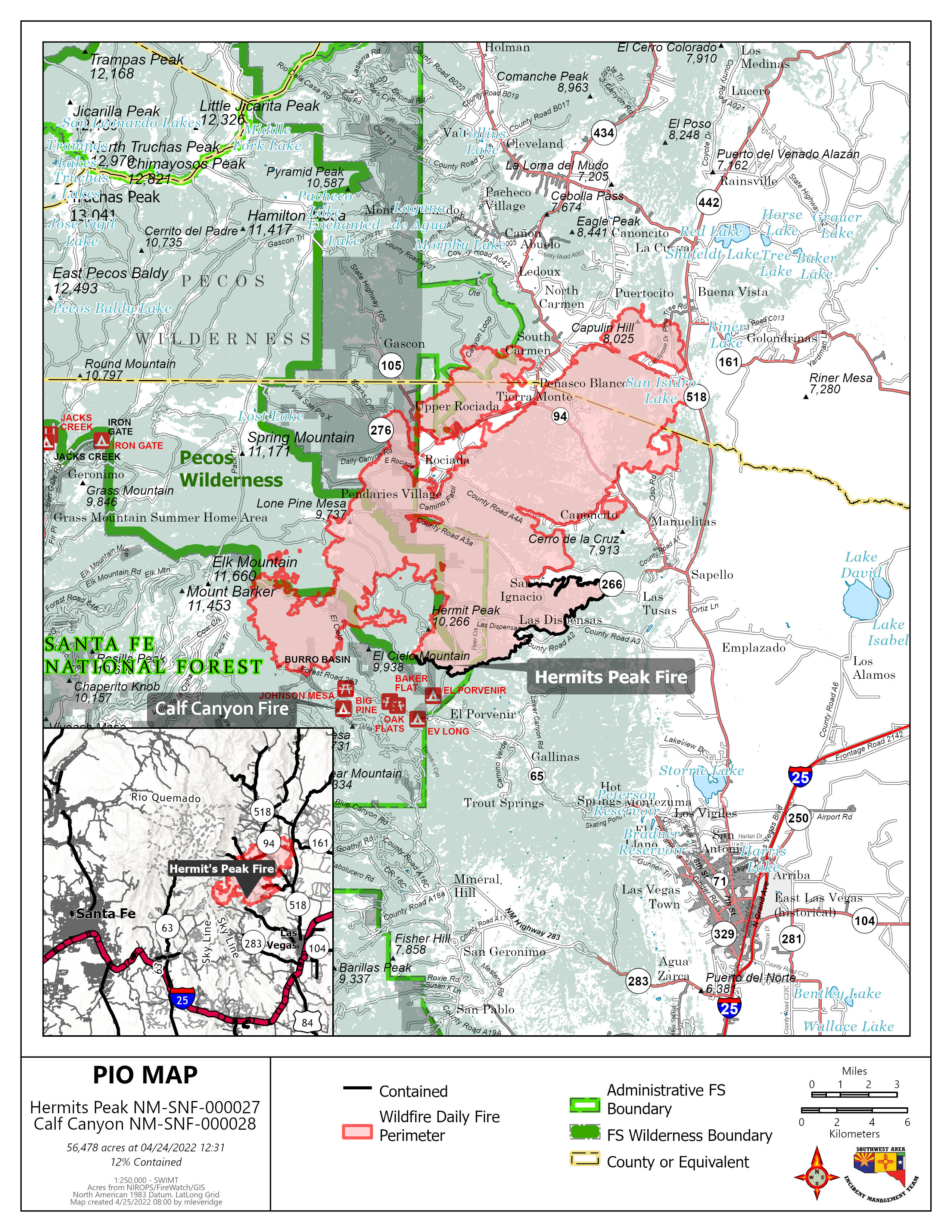
Las Vegas, NM 1:00 pm. Today the total combined acreage for Hermits Peak and Calf Canyon Fires is 54,004 acres. Reduced temperatures and wind speeds today will allow firefighters to make more progress. It is still imperative that residents comply with evacuation orders as citizen, fire fighter and law enforcement safety is the highest priority.

Community Evacuation Status in San Miguel and Mora Counties:

GO (mandatory full evacuation, colored green): In San Miguel County, Big Pine, Canovas Canyon, Porvenir Canyon, El Porvenir, Lower Canyon Road, Gallinas, Trout Springs, San Ignacio, Lone Pine Mesa, Chavez, Canoncito, Pendaries Village, Pendaries Valley East, Rociada, Upper Rociada and Tierra Monte Canon, La Canada, Las Tusas and Manuelitas are all still in GO status. 

In Mora County, Penasco Blanco, South Carmen, Rito Cebolla, Ledoux, Upper Morphy, Santiago Creek, Abuelo, Puertocito and Buena Vista are all still in GO status, as well as Zone 1, as identified on the map, which includes Mora, La Cueva, El Alto, Rainsville and Guadalupita. Zone 2, as identified on the map, is in GO status as of 7:00 Sunday morning.

SET (prepare for evacuation, colored yellow): In Mora County, Watrous and Valmora are currently in SET status

READY (get ready for possible evacuation, colored red): In San Miguel, the communities of Las Dispensas, County Road A3 and Los Alamitos remain in READY status.

San Miguel & Mora County Sheriff’s Departments and local law enforcement, along with the Incident Management Team will continue to perform re-assessments of these evacuation levels as the fire progresses. As we continue to work, please stay vigilant and adhere to instructions from press releases, law enforcement and fire personnel. The evacuation map is attached. This emerging situation remains extremely serious and refusal to evacuate could be a fatal decision. 

Please remember that drones are still prohibited in the temporary flight restriction zone, outlined on the map. The evacuation/flight zone map is attached. If drones enter the flight zone, firefighting aircraft are grounded.

Road Closures: In San Miguel County, State Road 65 at the Montezuma Pond, and CR A27 will be closed.  CR A3 and CR A4A will be closed. County Road A3A remains open to fire personnel and residents only. State Roads 105, 94, 266 and 276 will be closed. State Road 518 at the 94 is closed northbound. Road blocks will be in effect. Road closures in Mora County include State Road 161 at 518, State Road 442 at 518 and State Road 94 at 518.  State Road 518 is closed from La Cueva to Sapello. Mora residents are only able to evacuate on 434 to Angel Fire or 518 to Taos. County Road A011 is closed at 518. Routes to Las Vegas or I-25 aren’t accessible.

Power Outages: Power has been shut down in all evacuated areas. Lines will be re-energized when conditions are safe for fire personnel and law enforcement.

LIVESTOCK OWNERS: If you have livestock within the evacuation zone, contact NM State Police Dispatch at 505-425-6771 to coordinate a safe escort to your property to feed your animals. Do not enter the evacuation area un-escorted.

If you are currently evacuated and need to have prescriptions refilled, a Red Cross nurse at the evacuation shelter can assist you. Please go to the shelter and speak to the nurse there.

Property Losses: We understand that residents are anxious to discover losses and saves; however, fire areas are still too dangerous to access for property and residence assessments.  Crews are hoping that the areas will be accessible within the next few days. We know many residents are devastated by these potential losses, but please be patient and we’ll have information as soon as humanly possible.

County Fire Restrictions: All open burning (burning of crop land, fields, range land, debris, burning slash piles, prescribed burning or weed burning) in San Miguel County, shall be banned throughout the unincorporated areas of the County, and the provisions of SMC Ordinance 03-9-99ORD are in effect.  This ban shall prohibit any person from having, causing, starting, igniting and/or using open flame outside of a building, structure, automobile or other enclosed area anywhere, throughout the unincorporated portions of San Miguel County.

Shelter sites:

      San Miguel County: Old Memorial Middle School gym, Legion St. Las Vegas, 505-429-0336

      Mora County: Penasco High School gym, 13 Old School Road- Melissa Sandoval- 575-779-3057  

                Taos County Agricultural Center- 202 Chamisa Rd., Can accept small household pets

                Taos Youth and Family Center 407 Paseo del Canon

Shelter site for horses and livestock: The Zamora arena continues to be utilized to temporarily house evacuated horses and livestock.  The contact for livestock and horses is Matthew Romero, Livestock Inspector, 575-643-6805.

Link to Ready, Set Go, Wildland Fire Action Guide:

https://cms6.revize.com/revize/sanmiguelcounty/FINAL-new-mexico-RSG-guide-2017_000.pdf

Updates will be posted on San Miguel County OEM, Sheriff and Fire Facebook pages

Subscribe to