
May 29 Lost Lake Update
Related Incident: Lost Lake Fire
Publication Type: News
May 29, 2021
Safety: The health and safety of firefighters and the public are always our first priority. Please stay away from the Lost Lake Fire area to allow fire personnel to safely work. Drive slowly along roadways where fire traffic are working, and do not stop.
Weather: Weather is anticipated to be cooler with calmer winds than Saturday, though winds may reach 25mph at times.
Primary and Cooperating Agencies: Bureau of Indian Affairs, Colorado River Indian Tribes, U.S. Fish and Wildlife Service, Bureau of Land Management, U.S. Forest Service, Riverside County Fire and other cooperating entities.
Red Flag Fire Weather Again Today FINAL FIRE UPDATE
Related Incident: Perins Peak Fire
Publication Type: News
Media Contact: 970-316-3077
InciWeb: https://inciweb.nwcg.gov/incident/8120/
Perins Peak Fire 36 contained
Related Incident: Perins Peak Fire
Publication Type: News
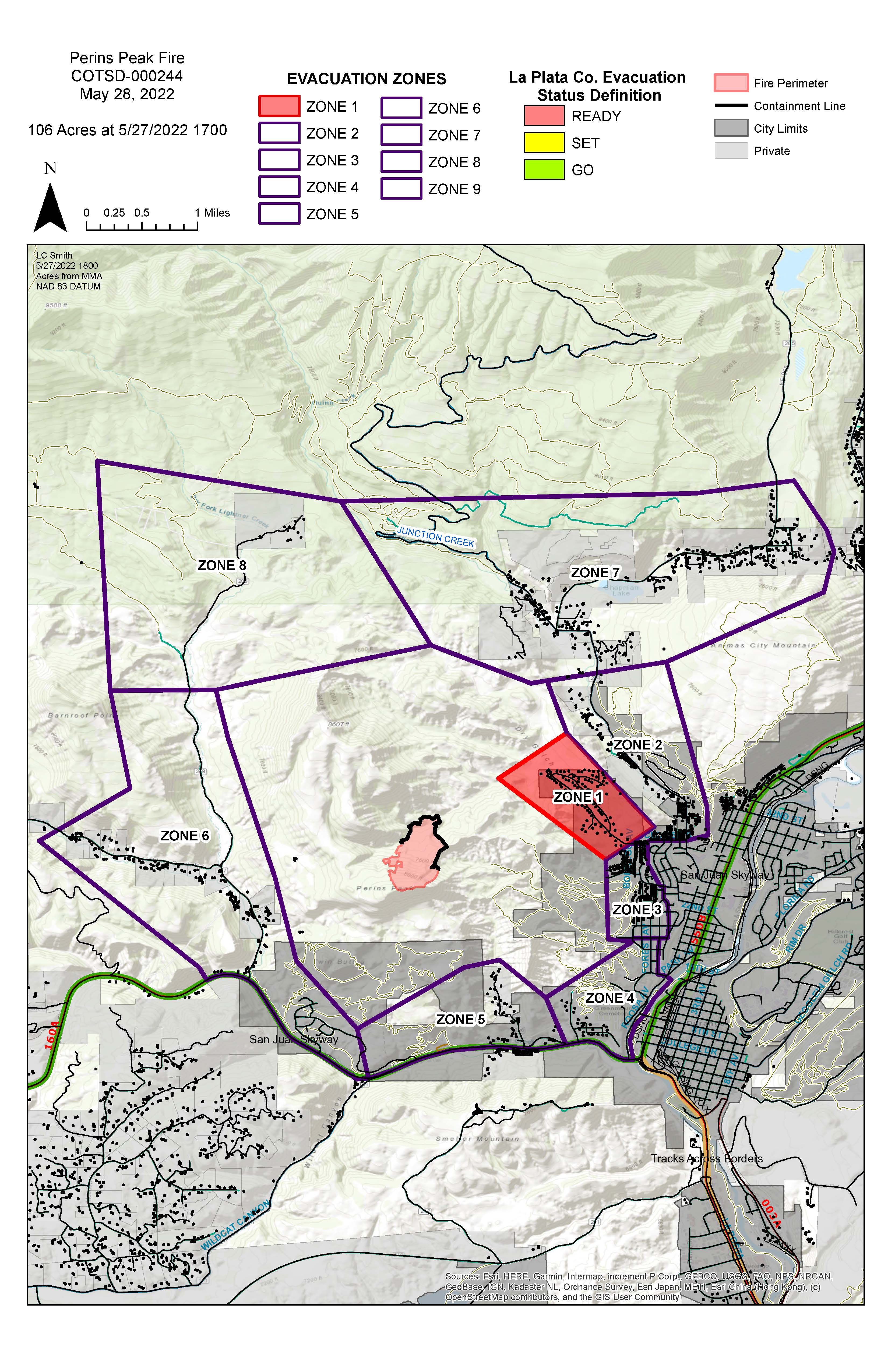
Durango, CO, 27 May 2022—The Perins Peak Fire remains at 102 acres and is now 36% contained. Yesterday, firefighters successfully lined the entire fire and began mopping up and reinforcing the fire’s heel.
This morning, helicopters shuttled hotshots to the top of the fire while other crews hiked in from the bottom. Aircraft usage will continue today in support of mop-up as crews reinforce the fireline and increase containment.
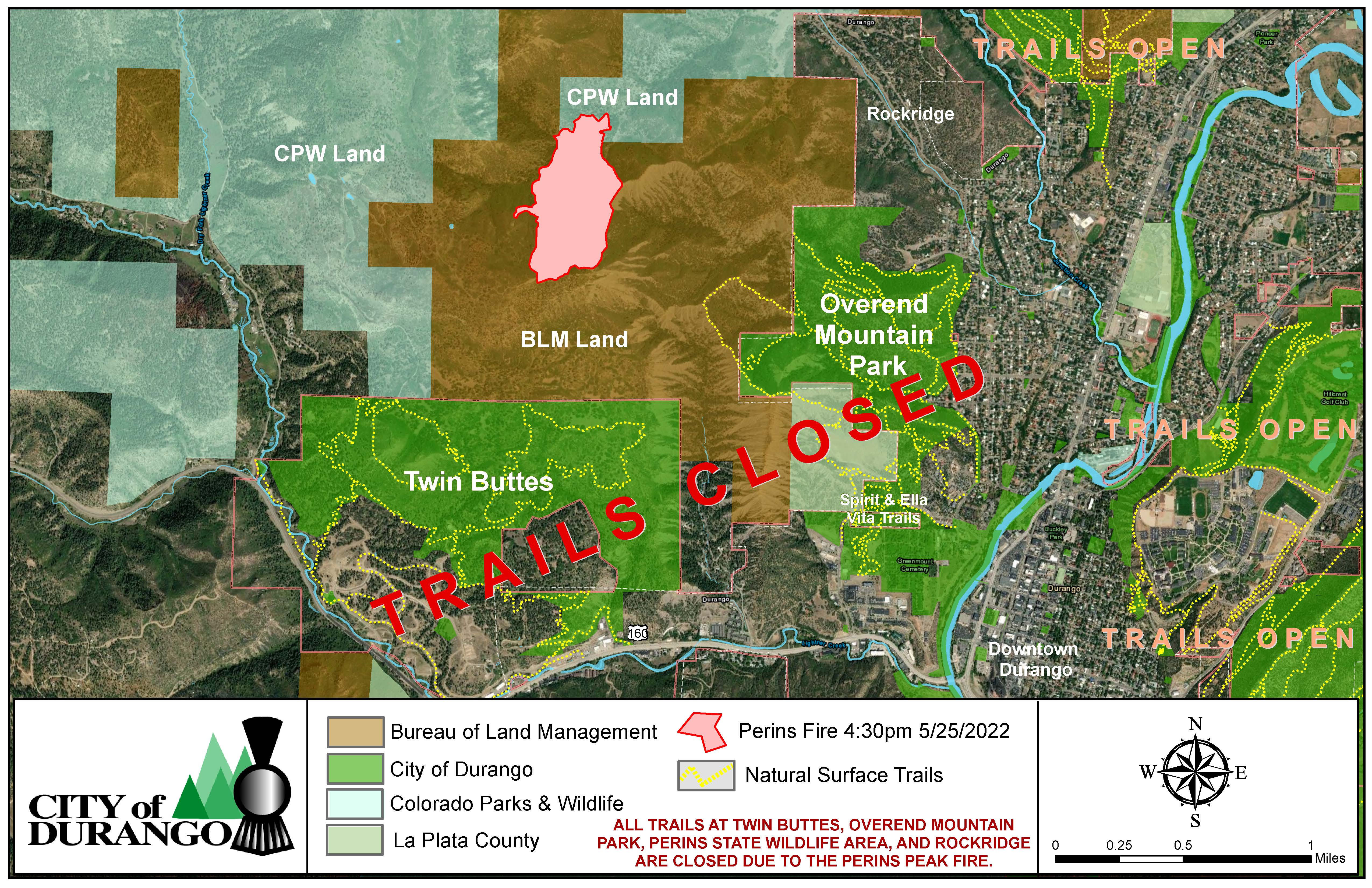
The pre-evacuation order has been lifted for County Road 206 and County Road 208 (zones 5 and 6 on the attached map). A pre-evacuation notice remains in place for the Rock Ridge subdivision. For more information on evacuations, visit the La Plata County Evacuations Map or call the information line: 970-385-8700. Trail access has been closed to Overend Mountain Park, Twin Buttes, and Perins State Wildlife Area.
A Red Flag warning is in effect today and Saturday, with gusty winds, low relative humidity, and high temperatures expected throughout the holiday weekend. These critical fire weather conditions could challenge fire crews, making a robust fireline especially crucial.
Remember that drones are strictly prohibited from flying near an active wildfire. This activity is both illegal and extremely dangerous. A temporary flight restriction remains in place for five nautical miles around the Perins Peak Fire, including much of Durango and surrounding area.
-BLM-
The BLM manages more than 245 million acres of public land located primarily in 12 western states, including Alaska, on behalf of the American people. The BLM also administers 700 million acres of sub-surface mineral estate throughout the nation. Our mission is to sustain the health, diversity, and productivity of America’s public lands for the use and enjoyment of present and future generations.
Durango Area Trails Closures
Related Incident: Perins Peak Fire
Publication Type: Closures
Trail closures have been lifted. Perins State Wildlife Area remains closed through July to protect sensitive wildlife.
Perins Peak Fire Update May 26
Related Incident: Perins Peak Fire
Publication Type: News
Media Contact: 970-316-3077
InciWeb: https://inciweb.nwcg.gov/incident/8120/
Durango, CO, 26 May 2022—The Perins Peak Fire saw no growth during yesterday’s operational period, and it was mapped at 102 acres. Firefighters made good progress working with multiple single engine airtankers and helicopters to construct and secure fireline. Engine crews installed a hose lay to the heel of the fire and patrolled the Rockwood neighborhood.
Hot shot crews hiked into the fire early this morning to continue line construction. Heavy aircraft usage will continue today as crews work to secure the fireline prior to the incoming Red Flag conditions. Fire managers expect to show some containment on the incident by the end of shift today.
Favorable fire weather conditions are likely again today though humidity remains low, between 7-12% and west winds 10-15 miles per hour. Beginning Friday morning, a Red Flag warning will be in effect with gusty winds, low relative humidity, and high temperatures throughout the holiday weekend. These critical fire weather conditions could pose challenges to firefighters, making today’s progress especially crucial.
Remember that drones are strictly prohibited from flying near an active wildfire. This activity is both illegal and extremely dangerous. A temporary flight restriction remains in place for five nautical miles around the Perins Peak Fire.Perins Peak Fire Update May 25
Related Incident: Perins Peak Fire
Publication Type: News
Media Contact: 970-316-3077
Email: 2022.perinspeak@firenet.gov
InciWeb: https://inciweb.nwcg.gov/incident/8120/
Perins Peak Fire Update
Durango, CO, 25 May 2022—The Perins Peak Fire is burning northwest of Durango, Colorado on Bureau of Land Management and Colorado Parks and Wildlife land. The San Juan Type III Incident Management Team is in command of the fire, which was mapped Tuesday evening at 105 acres. The cause of the fire is under investigation and is suspected to be a human-caused ignition.
The Perins Peak Fire was first reported around 5pm on May 24th. The initial attack included a substantial aviation component with multiple air tankers and helicopters. Due to the safety concerns regarding rugged terrain and no road access ground resources did not engage the fire. Several hot shot crews and other resources will be hiking into the fire early Wednesday morning.
The fire is burning in dense Gamel oak as well as mixed conifer in the drainage bottoms. The fire spread rapidly from the bottom of Rock Ridge Trail to the top of Perins Peak and has reached the Lightner Creek Fire scar from 2017.
A pre-evacuation notice has been ordered for County Road 208 and the Dry Fork and Rock Ridge subdivisions as well as County Road 206 to Highway 160. Trail access has been closed to Overend Mountain Park, Twin Buttes, and Perins State Wildlife Area. For more information on evacuations, visit the La Plata County Evacuations Map or call the information line: 970-385-8700.
La Plata County’s emergency notification system (commonly referred to as “Reverse 9-1-1”) includes cell phones and VoIP (Voice over Internet Protocol). Residents who live in La Plata County may register up to five cell or Internet phone numbers with a physical street address, ensuring that emergency notifications are received even when residents are not at home or if they don’t have a land line. To sign up, visit http://bit.ly/LPCCodeRed.
A public meeting will be held tonight at 6pm at the La Plata County Administration Building Board Room, 1101 East 2nd Avenue, Durango, CO. Seating is limited, so a virtual option will be available: https://us02web.zoom.us/j/86550880765?pwd=T0lvaC9rK0R6eXB2QUZ2ODdUZnF1UT09 Passcode: 466417
Or, dial in at: (669) 900-9128
Webinar ID: 865 5088 0765
For regularly updated information, please visit InciWeb: https://inciweb.nwcg.gov/incident/8120/
###
Warmer Temperatures and Wind will Challenge Firefighters Tuesday
Related Incident: Elgin Bridge Fire
Publication Type: News
Elgin, AZ (5/24/22) – Fueled by winds and pockets of dry vegetation, the fire stayed active overnight. The fire made a push to the east, but firefighters were able to safely and directly engage it to keep it from coming off Mustang Mountain and toward high priority values at risk. One of today’s main objectives is to keep the fire from moving to the east near kilovolt (kV) lines that supply power to the communities of Fort Huachuca and Sierra Vista. To meet those objectives, additional hand crews and aircraft have been ordered for Tuesday. Crews will also work today to establish containment line at the head of the fire to keep the fire south of State Route 82 and out of the Rain Valley community. Other objectives include, keeping the fire away from Upper Elgin Road to protect the communities of Elgin and Sonoita and slowing spread to the southeast to protect the Babacomari Ranch.
###
Cerro Pelado PostFire BAER Assessment Summary Released
Related Incident: Cerro Pelado Post-Fire BAER
Publication Type: News
CERRO PELADO POST-FIRE BAER ASSESSMENT SUMMARY RELEASED
The Forest Service Santa Fe National Forest (USFS) completed its BAER post-fire assessment of the Cerro Pelado burned area and affected watersheds to determine their response, soil conditions, potential threats, and recommended BAER emergency stabilization measures and actions on National Forest System (NFS) lands. BAER emergency treatments and activities are designed to decreased possible impacts to critical values from the burned areas during rainstorm events such as: life and safety, property, critical natural resources, and cultural resources.
NOTE: Attached below as “Related Information” is a PDF document called “Cerro Pelado Post-Fire BAER Assessment Summary”.
BAER SAFETY MESSAGE: Everyone near and downstream from the burned areas should remain alert and stay updated on weather conditions that may result in rain and increased water runoff. Flash flooding may occur quickly during rain events. Be prepared to act. Current weather and emergency notifications can be found at the National Weather Service website: www.weather.gov/abq/.
NWSABQ Thunderstorm Forecast for NM Burn Scars
Related Incident: Cerro Pelado Post-Fire BAER
Publication Type: News
NOAA National Weather Service-Albuquerque Office:
Thunderstorm Forecast for NM Burn Scars starting July 10 through July 14
This table below indicates the probability for thunderstorms over New Mexico wildfire burn areas. Storm motion and atmospheric moisture content are also listed as these factors can have considerable influence on the risk for burn scar flash flooding. Storm motion is the direction that storms will move toward. This product is experimental and for planning purposes only.
Go to the Photos Tab on this InciWeb Page for a close-up image of the NWS table below.
For the most up-to-date NWS forecast for NM “burn scar storms” go to:
Albuquerque, NM (weather.gov) and click on the “Burn Scar Storms” header on the right side of the page under NWS Albuquerque.

Forest Service Receives PostFire BAER Emergency Treatment Funding
Related Incident: Cerro Pelado Post-Fire BAER
Publication Type: News
FOREST SERVICE RECEIVES FUNDING FOR POST-FIRE BAER EMERGENCY TREATMENTS & ACTIONS
The Forest Service (USFS) recently completed post-fire Burned Area Emergency Response (BAER) assessments for emergency stabilization measures and actions on National Forest System (NFS) lands burned by the Cerro Pelado Fire and Hermits Peak-Calf Canyon Fires.
BAER emergency treatments and activities are designed to decrease possible post-fire impacts like flash flooding and debris-flows and protect BAER critical values such as life and safety, property, critical natural resources and cultural resources.
Hermits Peak and Calf Canyon (HPCC) Fires:
As of July 6, Phase 1 and Phase 2 BAER treatments total $2.5 million for the Santa Fe NF. This total includes funding for road stabilization and storm proofing work, road storm inspection and response, guardrail repair, burned area signage, aerial seeding, heritage site protection, and channel debris removal.
As of July 6, BAER treatments total $322,600 for the Carson NF. This total includes funding for road stabilization and storm proofing work, road storm inspection and response, and burned area signage.
Cerro Pelado Fire:
As of July 6, BAER treatment funding includes $213,000 for road infrastructure protection, burned area signage, rapid response to detect noxious weeds, and ancestral pueblo-cultural resources protection.
BAER SAFETY MESSAGE: Everyone near and downstream from the burned areas should remain alert and stay updated on weather conditions that may result in heavy rains and increased water runoff. Flash flooding may occur quickly during heavy rain events. Be prepared to act. Current weather and emergency notifications can be found at the National Weather Service website: www.weather.gov/abq/.