
Potter Windigo Big Swamp Daily Fire Update 823
Related Incident: Potter Fire
Publication Type: News
Windigo-Potter-Big Swamp - Fire Update
August 23, 2022
Fire Information Phone: 541-625-0687 (8am - 7pm)
Email: 2022.Windigo@firenet.gov
Potter Fire InciWeb: https://inciweb.nwcg.gov/incident/8291/
Windigo Fire InciWeb: https://inciweb.nwcg.gov/incident/8292/
Big Swamp InciWeb: https://inciweb.nwcg.gov/incident/8323/
Facebook: https://www.facebook.com/WindigoPotterBigSwampFireInfo/
Weather: Temperatures will be a few degrees higher with lower humidity than yesterday as we continue the forecasted warming and drying trend this week. Temperatures will be in the low to mid 80s across both fires, with humidities from 28-33%. Light winds are expected early, increasing to west-northwest winds 5-10 mph in the afternoon.
Big Swamp Fire: The sprinkler system continues to aid firefighters in checking any forward advance of the fire along the 2153 Road. Firefighters are looking for and extinguishing any remaining pockets of heat near the fireline, and repairs are ongoing to roads and control lines.
Potter Fire: Fire crews mopped up along the 2167 Road and continued to patrol around the fire perimeter, looking for any remaining hot spots near control lines. Firefighters were monitoring for spot fires as the fire moved downhill towards control lines on the 269 road.
Camel Hump Fire: Firefighters observed creeping and smoldering fire behavior yesterday, with some heavy fuels still burning on the interior of the fire. Firefighters are wary of a snag patch and are working to mitigate hazard trees. Fire crews worked to secure the edge of the fire and are scouting for opportunities to run a hose lay around the fire to deliver water to the fireline.
Windigo Fire: Work on the Windigo Fire is rapidly winding down as firefighters complete repair work to areas disturbed by fire suppression activity. Remaining dozer lines and hand lines are being rehabilitated to restore natural drainage on the landscape and minimize the potential for sediment to flow into local streams.
Resources: 17 hand crews, 10 engines, 3 dozers, 10 water tenders, 5 helicopters. Total personnel 689.
Closures: Reductions to the closure areas are currently being evaluated by the Forest Service. For firefighter and public safety, follow the Big Swamp, Windigo, and Potter Fires. Additional Potter Fire Road Closure – https://www.fs.usda.gov/alerts/umpqua/alerts-notices Pacific Crest Trail – visit https://www.pcta.org/discover-the-trail/closures/oregon/ for more information.
Public Safety: As fire activity diminishes, hazards from fire effects and suppression activities remain. Crews and equipment continue to use roads for both suppression and post-fire suppression repair. Activities like brushing and chipping along roadsides and falling trees remain hazards on the landscape. You can help keep firefighters and the public safe by adhering to the closure orders until they are officially lifted.
Windigo Fire
Size: Approx. 1,007 acres
Containment: 98%
Location: 20 mi SW of La Pine, OR
Cause: Lightning
Potter Fire
Size: Approx. 622 acres
Containment: 84%
Location: 8 mi NE of Toketee Lake
Cause: Lightning
Camel Hump
Size: Approx. 6 acres
Containment: 0%
Location: 6 miles SW of Potter Mountain
Cause: Lightning
Big Swamp
Size: Approx. 110 acres
Containment: 69%
Location: 6.5 mi N of Lemolo Lake
Cause: Lightning
Perspectiva de humo 22 Agosto 2022
Related Incident: Potter Fire
Publication Type: News
Linea de Informacion: 541-625-0687 (8am - 7pm) Email: 2022.Windigo@firenet.govIncendio Potter InciWeb: https://inciweb.nwcg.gov/incident/8291/Incendio Windigo InciWeb: https://inciweb.nwcg.gov/incident/8292/ Incendio Big Swamp InciWeb: https://inciweb.nwcg.gov/incident/8323/Facebook: https://www.facebook.com/WindigoPotterBigSwampFireInfo/
Condiciones climaticas: Se esperan temperaturas alrededor de los 90 grados en las partes menos elevadas y de los 80 grados y mas en el área sobre la cresta de la montana. La humedad estará dentro de un10%. En la noche de hoy, se espera un mejor recuperamiento de la humedad trayendo como consecuencia condiciones climáticas un poco mas moderadas en los terrenos menos elevados. Se observara una tendencia de clima seco y caliente por lo menos hasta este jueves antes de que se observe un potencial de clima moderado.
Incendio Big Swamp: El dia de ayer, una mínima actividad del fuego fue reportada. El sistema de aspersión que fue instalado a lo largo de la pendiente media de la carretera 2153, ha logrado contener el incendio de una manera exitosa. Los bomberos continúan las operaciones de limpieza y de patrullado con el fin de eliminar espacios de emanacion de calor en el perímetro del fuego.
Incendio Potter: El fuego se incremento, retrocediendo hacia las líneas de control sobre la carretera 269. Los bomberos están aprovechando las condiciones favorables del clima, para llevar a cabo tacticas de quema en menor escala con el fin de eliminar material de combustión que todavía no se ha sido quemado a lo largo de las líneas de fuego. Se esta procediendo con el trabajo de desastillar y disminuir el numero de arboles quemados y peligrosos sobre el eje restante de las líneas del incendio.Mientras el material de combustion se quema lentamente, se lograraa observar la presencia de humo desde el interior de los escombros y de la vegetación.
Incendio Camel Hump: Se origino otro incendio causado por la acción de relámpagos que se dieron inicio en las tierras vírgenes de Boulder Creek. Este incidente será manejado por el grupo NW Team 10. Se ha dado una respuesta coordinada por los bomberos en el terreno y los recursos aéreos, dándose a la tarea de inhibir el Incendio Camel Hump. Por el momento, el incendio tiene un tamaño estimado de 10 acres.
Incendio Windigo: Ha sido designado un grupo de trabajo para el área del Incendio Windigo con el fin de reparar sistemas de camino, senderos de montana y líneas de bulldozers que fueron utilizadas por los bomberos. Con un esfuerzo de reparar y minimizar los impactos en el terreno, los asesores de recursos continúan trabajando directamente con el equipo de bomberos en el área afectada. Por el momento, el incendio se encuentra en un estado de patrullaje. Recursos: 23 cuerpos de bomberos, 15 camiones de bomberos, 6 bulldozers, 6 cisternas, 2 helicopteros. Total de personal 761.
Cierre de caminos: Para la seguridad del público y de los bomberos, lea la información acerca de los incendios Big Swamp, Windigo, and Potter Fires.Informacion adicional de cierre de caminos para el incendio Potter, visite: https://www.fs.usda.gov/alerts/umpqua/alerts-noticesInformacion acerca de Pacific Crest Trail – visite https://www.pcta.org/discover-the-trail/closures/oregon/
Seguridad Publica: Tenga en cuenta, que cuando el incendio disminuye, siempre existen otros peligros como resultado de las actividades de supresión. Los Bomberos y sus equipos, continúan utilizando las carreteras para las reparaciones de supresión actuales y después del incendio. Permanecen las actividades de limpieza a lo largo de las carreteras (cepillando y desmenuzando material de combustión) y la eliminación de árboles peligrosos en el terreno.
Incendio Windigo Extension: Aprox. 1,007 acres Contenido: 96% Ubicacion: 20 mi SW de La Pine, OR Causa: Relampagos
Incendio Potter Extension: Aprox. 619 acres Contenidot: 72% Ubicacion: 8 mi NE de Toketee Lake Causa: Relampagos
Incendio Big SwampExtension: Aprox. 110 acres Contenidot: 57% Ubicacion: 6.5 mi N de Lemolo Lake Causa: Relampagos
McKinney and Yeti Fire Area Closure Order Map 05052211
Related Incident: McKinney Fire
Publication Type: Closures
McKinney and Yeti Fire Area Closure Order 05052211
Related Incident: McKinney Fire
Publication Type: Closures
McKinney and Yeti Fire Area Closure Order
Related Incident: McKinney Fire
Publication Type: Closures
Closure Order Rescinded Dismal and Patrol Point Fires Sept 15 2022
Related Incident: Dismal Fire
Publication Type: Closures
The closure order for areas of the Payette National Forest and Wilderness Area near the Dismal and Patrol Point Fires has been lifted, as of September 15, 2022 at 00:01.
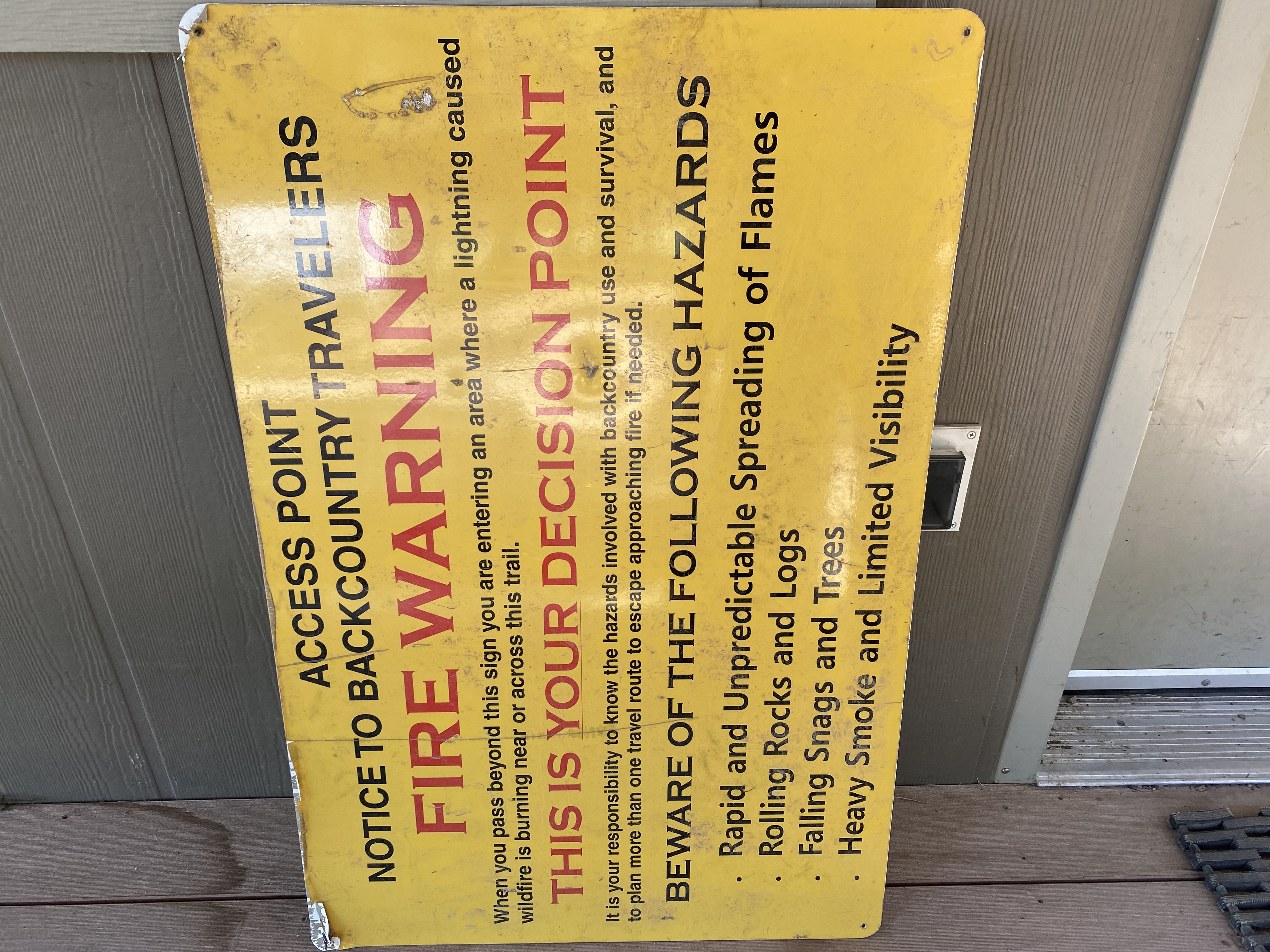
However, there is still fire activity in the area. Backcountry travelers have a responsibility to know the hazards involved with backcountry use and survival, and to plan more than one travel route to escape approaching fire if needed. Beware of the following hazards: rapid and unpredictable spread of flames, rolling rocks and logs, falling snags and trees, heavy smoke and limited visibility.
Dismal Fire and Patrol Point Fire Closure Order September 7 2022
Related Incident: Dismal Fire
Publication Type: Closures
A new Area Closure Order was issued on September 7, 2022 that covers the Dismal Fire and the Patrol Point Fire.
FIRE SUMMARY SEPTEMBER 12 2022
Related Incident: Wolf Fang Fire
Publication Type: News
The Central Idaho Dispatch Zone is at EXTREME Fire Danger
CENTRAL IDAHO FIRE RESTRICTIONS AREA IS IN STAGE I FIRE RESTRICTIONS
The Salmon-Challis National Forest has had six (6) new fires in the last week. To date, there have been 43 wildfires reported on the Salmon-Challis National Forest. 35 of those reported fires are out.
Saw Log Fire (September 10): The fire, located approximately 22 miles northwest of Challis on the Salmon-Cobalt Ranger District, is estimated at two (2) acres. The fire is burning timber with a litter understory. Ten firefighters are on scene working to suppress the fire.
Horse Fire (September 8): The fire is being updated separately and can be found on InciWeb at https://inciweb.nwcg.gov/incident/8416/.
Goat Fire (September 8): The lightning fire, located approximately 20 northwest of Challis on the Salmon-Cobalt Ranger District, was estimated at 0.10 acres. The fire burning in timber and fir is out.
Owl Fire (September 8): The fire is being updated separately and can be found on InciWeb at https://inciweb.nwcg.gov/incident/8416/.
Rocky Fire (September 7): The fire, located approximately nine (9) miles southwest of Leadore on the Leadore Ranger District, was estimated at two (2) acres. The fire, burning in grass, sagebrush, Douglas fire, and lodgepole, is out.
The Trail Fire (September 7): The fire, an unattended warming fire which was creeping away from the main fire, was located approximately eight (8) miles southwest of Mackay on the Lost River Ranger District and estimated at 0.10 acres. The fire is out.
The Bradley Fire (September 2): The lightning fire, located approximately 6.5 miles southeast of Gibbonsville on the North Fork Ranger District, is estimated at eight (8) acres. The fire burning in lodgepole pine, is out.
Siah Fire (August 17): The lightning fire, located approximately six (6) miles northwest of Indian Creek Guard Station on the Middle Fork Ranger District in the Frank Church River of No Return Wilderness, remains estimated at 11 acres. The fire is burning in grass, brush, and fir. There is very little fire activity or smoke. Risk to responders and public safety are the top priorities for the Siah Fire. The fire is surrounded on three sides by the Kiwah Fire from 2018 as well as the Little Pistol Fire from 2000 across Indian Creek from the fire. Due to the inaccessibility of the terrain and snag hazards, Fire Managers are assessing the fire by air.
Norton (August 1): The fire is being updated separately and can be found on InciWeb at https://inciweb.nwcg.gov/incident/8308/.
Moose (July 17): The fire is being updated separately and can be found on InciWeb at https://inciweb.nwcg.gov/incident/8249/.
Woodtick (July 14): The fire is being updated separately and can be found on InciWeb at https://inciweb.nwcg.gov/incident/8253/.
Wolf Fang Fire (July 13): The lightning fire is located approximately four (4) miles northeast of the confluence of Big Creek and the Middle Fork of the Salmon River in the Frank Church River of No Return Wilderness on the North Fork Ranger District. The 2,048 acre fire burning in spruce and fir is located in steep, rugged terrain. The majority of the fire activity on the back side Aggipah Mountain in the Aggipah Lake vicinity with additional fire activity west side of the fire above the Middle Fork of the Salmon River. Risk to responders and public safety are the top priorities for the Wolf Fang Fire. Due to the inaccessibility of the terrain and snag hazards, Middle Fork Peak lookout, a remote camera, and aviation are assessing the fire daily. The fire can be found on InciWeb at https://inciweb.nwcg.gov/incident/8273/.
Weather: The weather pattern will be going through an abrupt change in the next 24 hours. After another hot and extremely dry day under light wind, by early Tuesday morning, upper level low pressure anchored in Puget Sound will be merging with some subtropical moisture heading up from Nevada and Utah to bring wetting rains even as far north as the Montana border. This will continue through at least Thursday night, and likely into Friday. Moderate rains, thunderstorms, cooler afternoon temperatures, and high humidity will be the result. There is a risk of debris flows with the precipitation rates possible from thunderstorms on burn areas.
The forest is asking visitors to be aware of the EXTREME fire danger for the Salmon-Challis National Forest. The U.S. Forest Service, Idaho Department of Lands, and Bureau of Land Management in east-central Idaho are in Stage 1 fire restrictions. Stage 1 fire restrictions apply to federal, state, state endowment, private forestland and rangelands within the designated area. One Less Spark Means One Less Wildfire.
Nationally, there are 29 uncontained large fires being managed under a full suppression strategy and 78 large fires managed under a strategy other than full suppression. Smoke from fires in Idaho and the West is drifting into the vicinity. For more information go to https://fire.airnow.gov/.
Visit our website at: www.fs.usda.gov/scnf/, ‘Like Us’ on Facebook @salmonchallisnf, and ‘Follow Us’ on Twitter @salmonchallisnf.
FIRE SUMMARY SEPTEMBER 5 2022
Related Incident: Wolf Fang Fire
Publication Type: News
FIRE SUMMARY SEPTEMBER 5, 2022
The Central Idaho Dispatch Zone is at VERY HIGH Fire Danger
CENTRAL IDAHO FIRE RESTRICTIONS AREA IS IN STAGE I FIRE RESTRICTIONS
Salmon, Idaho- September 5, 2022- The Salmon-Challis National Forest has had two (2) new lightning fires in the last week.
The Bradley Fire (September 2): located approximately 6.5 miles southeast of Gibbonsville on the North Fork Ranger District, is estimated at 8 acres. The fire burning in lodgepole pine, is 100% contained and controlled. This fire is adjacent to the Continental Divide Trail (CDT) in the North Fork Sheep Creek drainage where it intersects with Pruvan Creek. Recreation crews have posted the area to communicate information with CDT hikers.
Granite Fire (September 1): The lightning fire, located approximately four (4) miles northwest of Gibbonsville on the North Fork Ranger District, is estimated at three (3) acres. The fire, burning in spruce and fir is out.
Quartz Fire (August 29): The lightning fire, located approximately 17 miles east of Salmon on the Salmon-Cobalt Ranger District is estimated at 0.10 acres. The fire was called out on August 30.
Norton (August 1): The lightning fire is located approximately seven miles northwest of Lower Loon Creek on the Middle Fork Ranger District in the Frank Church River of No Return Wilderness. The 2,546 acre fire burning in subalpine fir, Douglas fir, sagebrush, and grass is located in steep rugged terrain. The fire was active yesterday. Fire is established in the head of Sheep Creek and is backing down towards the Middle Fork of the Salmon River. The fire is under a point protection strategy, fire managers are utilizing air resources to determine action points and assess values in the vicinity. Fire managers continue to assess the fire using remote cameras and aircraft. The fire can be found on InciWeb at https://inciweb.nwcg.gov/incident/8308/.
Moose (July 17): The fire is being updated separately and can be found on InciWeb at https://inciweb.nwcg.gov/incident/8249/.
Woodtick (July 14): The lightning fire started as two separate fires approximately six (6) miles west, northwest of Meyers Cove on the Middle Fork Ranger District in the Frank Church River of No Return Wilderness. The 6,398 acre fire burning in timber, grass, and brush is located in steep rugged terrain. The fire was active yesterday on the west side of fire in the West Fork of Camas and Woodtick Creeks. The fire is under a point protection and confine and contain strategies with risk to responders and public safety being the top priority. The fire can be found on InciWeb at https://inciweb.nwcg.gov/incident/8253/.
Wolf Fang Fire (July 13): The lightning fire is located approximately four (4) miles northeast of the confluence of Big Creek and the Middle Fork of the Salmon River in the Frank Church River of No Return Wilderness on the North Fork Ranger District. The 1,568 acre fire burning in spruce and fir is located in steep, rugged terrain. The majority of the fire activity is in the Aggipah Mountain vicinity. The fire is also showing activity in the head of unnamed tributaries to both Ship Island and Waterfall Creek. Risk to responders and public safety are the top priorities for the Wolf Fang Fire. Due to the inaccessibility of the terrain and snag hazards, Middle Fork Peak lookout, a remote camera, and aviation are assessing the fire daily. The fire can be found on InciWeb at https://inciweb.nwcg.gov/incident/8273/.
To date, there have been 37 wildfires reported on the Salmon-Challis National Forest. 31 of those reported fires are out.
Weather: Strong high pressure ridge is in place to the south with a weak upper level trough sweeping along the Canadian border this morning. The latter feature will help to increase winds once again this afternoon especially across ridges of the Central Mountains. Otherwise, conditions will remain hot and dry with Haines Indices in the 5 to 6 range through midweek.
The forest is asking visitors to be aware of the VERY HIGH fire danger for the Salmon-Challis National Forest. The U.S. Forest Service, Idaho Department of Lands, and Bureau of Land Management in east-central Idaho are in Stage 1 fire restrictions. Stage 1 fire restrictions apply to federal, state, state endowment, private forestland and rangelands within the designated area. One Less Spark Means One Less Wildfire.
Nationally, there are 21 uncontained large fires being managed under a full suppression strategy and 53 large fires managed under a strategy other than full suppression. Smoke from fires in Idaho and the West is drifting into the vicinity. For more information go to https://fire.airnow.gov/.
Visit our website at: www.fs.usda.gov/scnf/, ‘Like Us’ on Facebook @salmonchallisnf, and ‘Follow Us’ on Twitter @salmonchallisnf.
####
FIRE SUMMARY AUGUST 29 2022
Related Incident: Wolf Fang Fire
Publication Type: News
FIRE SUMMARY AUGUST 29, 2022
The Central Idaho Dispatch Zone is at VERY HIGH Fire Danger
CENTRAL IDAHO FIRE RESTRICTIONS AREA IS IN STAGE I FIRE RESTRICTIONS
The Salmon-Challis National Forest has had five (5) new lightning fires in the last week.
Quartz Fire (August 29): The lightning fire, located approximately 17 miles east of Salmon on the Salmon-Cobalt Ranger District is estimated at 0.10 acres. Four firefighters are on scene working to suppress the fire burning in timber and grass. In addition, a helicopter is doing bucket drops on the fire.
Wheat Fire (August 26): The lightning fire, located approximately two (2) miles northeast of Corn Creek on the North Fork Ranger District, was estimated at ¼ acres. The fire was located in the burn scar from 2012 Mustang Fire. Four firefighters worked to suppress the fire in grass, brush, Ponderosa pine, and fir and the fire is out.
Filly Fire (August 24): The lightning fire, located approximately 30 miles northwest of North Fork on the North Fork Ranger District in the Frank Church River of No Return Wilderness, is estimated at 0.10 acres. The fire was burning a single tree in grass and snags, the fire is out.
Nelson Fire (August 22): The lightning fire, located approximately 24 miles northeast of Stanley on the Middle Fork Ranger District in the Frank Church River of No Return Wilderness, was estimated at 0.10 acres. Two (2) firefighers worked to suppress the fire in Douglas fir and the fire is out.
Iron Fire (August 22): The lightning fire, located approximately ¼ mile southwest of Iron Lake Campground on the Salmon-Cobalt Ranger District, was estimated at 0.10 acres. An engine and a handcrew squad worked to suppress the fire in grass and Ponderosa pine and the fire is out.
Wilson Fire (August 15): The lightning fire, located approximately four (4) miles southwest of Yellowjacket Campground on the North Fork Ranger District in the Frank Church River of No Return Wilderness, estimated at four (4) acres. The fire was burning in grass, brush, fir, and downed timber, the fire is out.
Petes Fire (August 14): The lightning fire, located approximately one (1) mile east of Moyer on the Salmon-Cobalt Ranger District, is estimated at nine (9) acres. The fire is out.
Norton (August 1): The lightning fire is located approximately seven miles northwest of Lower Loon Creek on the Middle Fork Ranger District in the Frank Church River of No Return Wilderness. The 1,859 acre fire burning in subalpine fir, Douglas fir, sagebrush, and grass is located in steep rugged terrain. The fire continues to be moderately active, the majority of the fire growth has generally been on the South and Southeast sides of the fire in the South Fork of Norton Creek. There has been activity in other drainages across the fire are. The fire is under a point protection strategy, fire managers are utilizing air resources to determine action points and assess values in the vicinity. Fire managers continue to assess the fire using remote cameras and aircraft. The fire can be found on InciWeb at https://inciweb.nwcg.gov/incident/8308/.
Moose (July 17): The fire is being updated separately and can be found on InciWeb at https://inciweb.nwcg.gov/incident/8249/.
Woodtick (July 14): The lightning fire started as two separate fires approximately six (6) miles west, northwest of Meyers Cove on the Middle Fork Ranger District in the Frank Church River of No Return Wilderness. The 6,063 acre fire burning in timber, grass, and brush is located in steep rugged terrain. The most active part of the fire has been on the west side of fire in the area where Woodtick Creek, Martindale Creek, and West Fork of Camas Creek meet. The fire has crossed over into the West Fork of Camas Creek. There is also still heat at the lower drainage edge of fire in Martindale Creek. The fire is under a point protection and confine and contain strategies with risk to responders and public safety being the top priority. The fire can be found on InciWeb at https://inciweb.nwcg.gov/incident/8253/.
Wolf Fang Fire (July 13): The lightning fire is located approximately four (4) miles northeast of the confluence of Big Creek and the Middle Fork of the Salmon River in the Frank Church River of No Return Wilderness on the North Fork Ranger District. The 1,521 acre fire burning in spruce and fir is located in steep, rugged terrain. On the north side of the fire, fire has moved into the Ship Island Creek drainage. To the east, the fire has crossed an unnamed tributary to Ship Island Creek, continuing to move east towards Aggipah Mountain. Risk to responders and public safety are the top priorities for the Wolf Fang Fire. Due to the inaccessibility of the terrain and snag hazards, Middle Fork Peak lookout, a remote camera, and aviation are assessing the fire daily. The fire can be found on InciWeb at https://inciweb.nwcg.gov/incident/8273/.
To date, there have been 35 wildfires reported on the Salmon-Challis National Forest. 29 of those reported fires are out.
Weather: High pressure will produce hot and dry weather through much of the week. Minimum humidity values in the low teens and single digits will be possible. Although light winds are expected through midweek.
The forest is asking visitors to be aware of the VERY HIGH fire danger for the Salmon-Challis National Forest. The U.S. Forest Service, Idaho Department of Lands, and Bureau of Land Management in east-central Idaho are in Stage 1 fire restrictions. Stage 1 fire restrictions apply to federal, state, state endowment, private forestland and rangelands within the designated area. One Less Spark Means One Less Wildfire.
Nationally, there are 17 uncontained large fires being managed under a full suppression strategy and 26 large fires managed under a strategy other than full suppression.
Visit our website at: www.fs.usda.gov/scnf/, ‘Like Us’ on Facebook @salmonchallisnf, and ‘Follow Us’ on Twitter @salmonchallisnf.
####