
Smoke Outlook
Related Incident: Red Fire
Publication Type: Announcement
Air quality in the forecast area has greatly improved over the last day. Today, mostly Good AQI in the foothill communities is likely, with Moderate AQI for sites within the park. Smoke may be increasing as fuels dry out and the fires become more active later in the week.
Current Air Quality
View current air quality conditions throughout Yosemite National Park and the region at https://fire.airnow.gov/
Smoke Outlook 912
Related Incident: Red Fire
Publication Type: Announcement
Expect hazy conditions with smoke lingering in the river drainages much of the day. Air quality should improve in the afternoons, with Good to Moderate AQI likely in the foothill communities. El Portal, Foresta, and Yosemite Valley will see higher concentrations due to their proximity to the fires. With the unsettled weather, there is potential for rain showers and gusty winds and air quality conditions could change quickly.
Current Air Quality - View current air quality conditions throughout Yosemite National Park and the region at https://fire.airnow.gov/
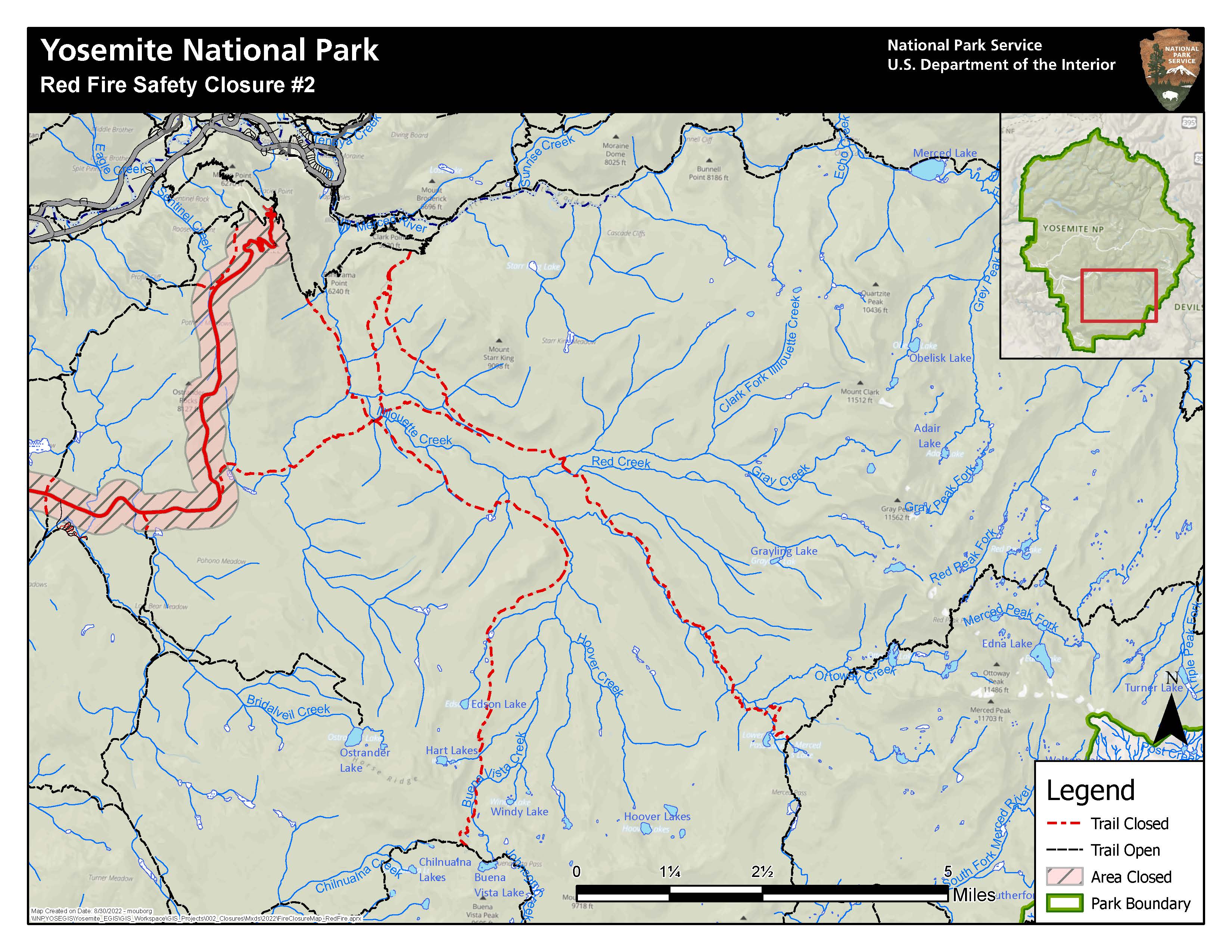
Smoke Outlook
Related Incident: Red Fire
Publication Type: Announcement
Widespread smoke/haze can be expected over the region due to local fires and other fires across the state which will result in primarily Moderate AQI for all locations. Periods of increased smoke can be expected during the morning through midday, especially within the Tuolumne Rivers, Merced River, Chilnuana Creek, and other nearby drainages, as a result of the Red and Rodgers Fires smoke settling into the valleys during the overnight. Up to Unhealthy AQI can be expected for many park locations with up to Very Unhealthy AQI within the Yosemite Valley each day.
With an unsettled forecast this weekend there is potential for rain showers and gusty winds. There will be potential for quick changes in weather and air quality conditions with rain showers helping clear the air, and gusty winds pushing smoke in any direction.
Current Air Quality
View current air quality conditions throughout Yosemite National Park and the region at https://fire.airnow.gov/
Smoke Outlook
Related Incident: Red Fire
Publication Type: Announcement
Smoke from multiple California wildfires is impacting air quality this morning throughout the region with at least Moderate to Unhealthy for Sensitive Groups (USG) Air Quality Index (AQI) for all locations. Conditions will improve by early afternoon for most with Good to Moderate AQI for the late afternoon. Smoke will once again settle this evening and overnight with air quality impacts expected for Saturday morning.
The potential for cloud cover throughout the weekend may cause smoke to linger later into the daytime before improving. However, the potential for rain showers and outflow winds may create cleaner air for some while pushing smoke to others. Overall, continue to expect the largest air quality impacts during the morning hours with at least some improvement for the afternoons.
Current Air Quality
View current air quality conditions throughout Yosemite National Park and the region at https://fire.airnow.gov/
Smoke Outlook
Related Incident: Red Fire
Publication Type: Announcement
Smoke from the Red, Aspen and Rodgers Fires will impact air quality throughout the Merced River drainage from Yosemite Valley westward to Lake McClure as well as areas of southern Yosemite NP southwest towards the central valley. Largest smoke impacts will be in within the park with short-term AQI reaching Unhealthy for most locations, and even Very Unhealthy to Hazardous for Yosemite Village. Smoke from the Rodgers and Aspen Fires will settle into the Tuolumne River and nearby valleys with Moderate-USG AQI at times from Tuolumne Meadows to Hetch Hetchy Reservoir, Hodgdon Meadows, and to Groveland and nearby areas, primarily during the morning. Light smoke will also impact Lee Vining and Mammoth Lakes at times. Smoke from Yosemite NP fires and other fires in California will also contribute to smoke impacts along the foothills, including the Mariposa area. Current Air Quality View current air quality conditions throughout Yosemite National Park and the region at https://fire.airnow.gov/
Smoke Outlook
Related Incident: Red Fire
Publication Type: Announcement
Smoke outlook: https://outlooks.airfire.org/outlook/17996aec
Four Corners Fire Closure Order September 15 2022
Related Incident: Four Corners Fire
Publication Type: Closures
Order Number: 0402-04-95
UNITED STATES DEPARTMENT OF AGRICULTURE FOREST SERVICE BOISE & PAYETTE NATIONAL FORESTS CASCADE, EMMETT, & COUNCIL RANGER DISTRICT Four Corners Fire Area, Roads, and Trail Closure (For Public Safety)
PROHIBITIONS: Pursuant to 16 U.S.C. § 551 and 36 CFR 261.50 (a) and (b), the following acts are prohibited on the National Forest System (NFS) lands, roads, and trails in the Cascade and Emmett Ranger Districts, Boise National Forest, and the Council Ranger District, Payette National Forest, described below and shown on the attached map incorporated into this Order in Exhibit A(“Closed Area, Roads, and Trails”).1. Going into or being upon the Closed Area. 36 CFR 261.52(e)2. Being on the Closed Trails. 36 CFR 261.55(a)3. Being on the Closed Roads. 36 CFR 261.54 (e)EXEMPTIONS: Pursuant to 36 CFR 261.50(e), the following persons are exempt from this Order:1. Persons with a special use authorization or other Forest Service authorizationspecifically exempting them from the effect of this Order.2. Any Federal, State, or local officer, or member of an organized rescue or firefighting force in the performance of an official duty.3. Federal or State administrative personnel in the performance of an official duty.
CLOSED AREA, ROADS AND TRAILS:Closed Area: All NFS lands within the following boundaries: Beginning at the northeast corner of Section 15 in Township 13N, Range 3E; Continuing west along the northern edge of Section 15 in Township 13N, Range 3E to itsjunction with the southeast corner of Section 9 in Township 13N, Range 3E; Continuing north along the eastern edge of Section 9 in Township 13N, Range 3E to itsjunction with the southeast corner of Section 4 in Township 13N, Range 3E; Continuing north along the eastern edge of Section 4 in Township 13N, Range 3E to itsjunction with the southern boundary of Section 33 in Township 14N, Range 3E; Continuing west along the southern edge of Section 33 in Township 14N, Range 3E to itsjunction with the southeast corner of Section 32 in Township 14N, Range 3E; Continuing north along the eastern edge of Section 32 in Township 14N, Range 3E to itsjunction with the southeast corner of Section 29 in Township 14N, R3E; Continuing north along the eastern edge of Section 29 in Township 14N, Range 3E to itsjunction with NFS Road (NFSR) 435;2 Continuing northwesterly along NFSR 435 to its junction with the southern boundary ofSection 13 in Township 14N, Range 2E; Continuing west along the southern edge of Section 13 in Township 14N, Range 2E to itsjunction with the southeast corner of Section 14 in Township 14N, Range 2E; Continuing west along the southern edge of Section 14 in Township 14N, Range 2E to itsjunction with the northwest corner of Section 23 in Township 14N, Range 2E; Continuing south along the western edge of Section 23 in Township 14N, Range 2E to itsjunction with NFSR 231; Continuing southwards along NFSR 231 to its junction with NFSR 180 in Township 14N,Range 2E, Section 28; Continuing southwards along NFSR 180 to its junction with western edge of Section 4 inTownship 13N, Range 2E; Continuing south along the western edge of Section 4 in Township 13N, Range 2E to itssouthwest corner; Continuing east along the southern edge of Section 4 in Township 13N, Range 2E to itsjunction with NFSR 625G1; Continuing southwards along NFSR 625G1 to its intersection with NFSR 625G inTownship 13N, Range 2E, Section 9; Continuing easterly along NFSR 625G to its junction with NFS Trail (NFST) 131 (WestMountain Trail) in Township 13N, Range 2E, Section 10; Continuing easterly along NFST 131 to its intersection with the western edge of Section 12in Township 13N, Range 2E; Continuing south along the western boundary of Section 12 in Township 13N, Range 2E toits junction with the northwest corner of Section 13 in Township 13N, Range 2E; Continuing south along the western boundary of Section 13 in Township 13N, Range 2E tothe southwest corner of Section 13 in Township 13N, Range 2E; Continuing east along the southern boundary of Section 13 in Township 13N, Range 2E tothe southeast corner of Section 13 in Township 13N, Range 2E; Continuing north along the eastern boundary of Section 13 in Township 13N, Range 2E tothe southwest corner of Section 18 in Township 13N, Range 3E; Continuing east along the southern boundary of Section 18 in Township 13N, Range 3E tothe junction with the northeast corner of Section 19 in Township 13N, Range 3E; Continuing south along the eastern boundary of Section 19 in Township 13N, Range 3E tothe intersection of NFSR 446; Continuing east along NFSR 446 to the junction with NFSR 446B in Township 13N, Range3E, Section 20; Continuing east along NFSR 446B to its terminus in Township 13N, Range 3E, Section 20; Continuing east along the southern watershed boundary of Moores Creek to its intersectionwith the eastern boundary of Section 15 in Township 13N, Range 3E; Continuing north along the eastern boundary of Section 15 in Township 13N, Range 3E andending at its northeast corner.
Closed Roads: All NFS Roads within the Closed Area and all NFS Roads bordering the ClosedArea, except:3o EXCLUDED/OPEN: NFSR 435, NFSR 231, NFSR 180, NFSR 625G1, NFSR625G, NFSR 446, and NFSR 446B.Closed Trails: All NFS Trails within the Closed Area and all NFS Trails bordering the ClosedArea, except:o EXCLUDED/OPEN: NFST 131.
PURPOSE:To protect public safety during active firefighting operations.
IMPLEMENTATION:
1. This Order will be in effect September 15, 2022 at 6:00 P.M. and shall remain in effectuntil December 1, 2022, at 5:00 P.M.
2. A map identifying the Closed Area, Roads, and Trails is attached and made part of this Order.
3. A violation of the above prohibition(s) is punishable by a fine of not more than$5,000 for an individual or $10,000 for an organization, imprisonment for not morethan six months, or both. [16 U.S.C § 551, 18 U.S.C §§ 3559, 3571, 3581].
4. Further information regarding this Order may be obtained at the Boise Forest Supervisor’s Office (208) 373-4100, in Boise, ID and the Payette Forest Supervisor’s Office (208) 634-0700 in McCall, ID.
5. This Order supersedes and replaces Order No. 0402-04-94.Done at Boise, Idaho this _15th day of September 2022.
Signature of Forest Supervisors__________________________ ________________________
TAWNYA BRUMMETT Forest Supervisor Boise National Forest
LINDA JACKSON Forest Supervisor Payette National Forest
Four Corners Fire Area Closure Order 04020495
Related Incident: Four Corners Fire
Publication Type: Announcement
Forest Closure Update - On Sept. 15, Four Corners Fire Closure Order was issued and was reduced in size. See Closure Order #0402-04-95 below. Public can now access Snowbank Mtn. (FR 446) and travel through Anderson Creek (FR 435). Through traffic only on Anderson Creek Rd. Be aware of firefighter traffic and heavy equipment working in the area.
Four Corners Fire Update September 16 2022
Related Incident: Four Corners Fire
Publication Type: News
Yesterday evening the closure area of the fire was reduced in size (see Maps tab). Recreationists can now enjoy Snowbank Mountain and the areas surrounding the fire. Travel on the Anderson Creek 435 road will be allowed but fire officials ask that you drive slowly and watch out for fire traffic who are still patrolling and working in the area.
Today crews will continue to focus on mopping up further into the fire from the containment lines. Even though the moisture in the area has increased lately the rainfall is not putting out the fire. Firefighters still need to hike into the fire and mix the wet soil with the smoldering duff edges and the large dead logs on the ground need to be cut up and broken apart to get moisture on them to be extinguished. Aircraft support will be available from the McCall airport if crews need water dropped in areas where there are no streams.
Repair work continues in areas where the fire is out cold. Excavators and hand crews are pulling back dirt berms to create a smooth, contoured surface and then brush and slash is spread back over the line. The slash will help protect the soil from erosion.
Smoke will continue to be visible within the fire perimeter. Do not call 911. Instead, report fire activity or smoke within the fire perimeter by calling 208-510-8412. Firefighters will continue to monitor the fire area by air and ground and will respond to any fire activity as necessary.
Weather: On Friday there is a 30% chance of rain showers and chance of thunderstorms in the afternoon. Temperatures will remain cool with highs expected to be in the low 60s. Cooler temperatures will remain through the weekend, along with higher humidity.
Fire Restrictions: There are currently no fire restrictions in the area. Residents and visitors are encouraged to exercise extreme caution if building campfires. Local fire restriction information can be found at: https://tinyurl.com/vptsh85r.
Air Quality: Specific information about local smoke levels, forecasts, and possible health impacts is available at https://outlooks.airfire.org/outlook/cc0ac676/.
Evacuation Information: Valley County Sheriff's Office announced the termination of evacuation status (ready-set-go) Please visit www.wildlandfirersg.org for evacuation level information.
Closure Information: The new closure includes an area around Collier Peak and the fire perimeter. Complete closure order for the Boise and Payette National Forests – including a full description and an accompanying map – is available at https://InciWeb.nwcg.gov/incident/closures/8331/.
Hunting Information - https://idfg.idaho.gov/blog/2016/08/get-current-fire-information-here