
91622 Tenmile Fire Update
Related Incident: Tenmile
Publication Type: News
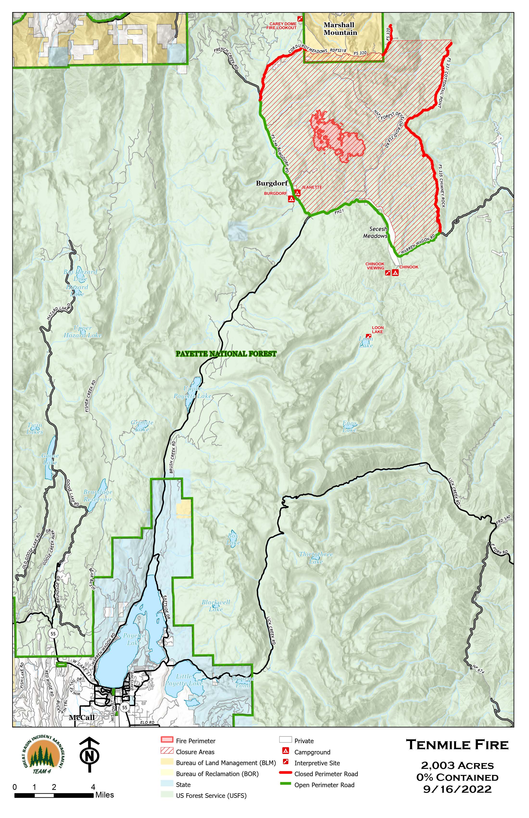
Today, fire crews will begin chipping vegetation debris that was removed along the 325 Road and from surrounding areas. Crews continue to make great progress on constructing containment lines around the Tenmile Fire, reducing the potential of fire impacting the communities of Burgdorf, Secesh, and Warren. The Payette National Forest closure has been modified to include areas northwest of the fire along the 318 Road to increase firefighter safety, as crews continue to construct containment lines north of the fire, expanding onto Bureau of Land Management managed lands.
Due to the recent precipitation in the area and decreased fire behavior, air quality has shifted to the good category. However, smoke may remain in areas near the fire. Visit airnow.gov for more information.
For the safety of firefighters and the public, two emergency fire area closure orders are in effect for the Tenmile Fire: one for the Payette National Forest and one for the Bureau of Land Management, Cottonwood Field Office. The closure orders, including a full description of the trails, roads, and areas closed, are available at https://inciweb.nwcg.gov/incident/closures/8401/.
Cottonwood BLM Closure
Related Incident: Tenmile
Publication Type: Closures
EMERGENCY CLOSURE and RESTRICTION ORDER -BLM Cottonwood Field Office Order No. ID-420-16
By order, the following Bureau of Land Management lands are closed to public access dueto fire suppression activities for the Tenmile Fire in the following area:
- All BLM-managed lands, commonly referred to as Marshall Mountain, located in Township 24 N., Range 5 E., Sections 31, 32, 33 & 34. Including, moving from the west to east, lands from the boundary with the U.S. Forest Service, all BLMmanaged lands south of Forest Service Road 318 and Forest Service Road 320, to the eastern boundary with U.S. Forest Service lands.
The authority for establishing this restriction is Title 43, Code of Federal Regulations, 8364.1. The restriction becomes effective immediately and shall remain in effect until revoked. The restriction does not apply to:
- Any Federal, state or local government officer or member of an organized rescue or fire fighting force while in the performance of an official duty.
- Any Bureau of Land Management employee, agent, contractor, or cooperator while in the performance of an official duty.
- Any person or group expressly authorized by an Authorized Officer to access the subject public land through the issuance of a permit or other use authorization instrument.
9152022 Tenmile Fire Update
Related Incident: Tenmile
Publication Type: News
Due to the recent precipitation in the area, air quality has shifted to the moderate category. However, smoke will remain in areas near the fire. Much of the smoke in the surrounding area is due to the large fires burning in other states. Visit airnow.gov for more information.
For the safety of firefighters and the public, two emergency fire area closure orders are in effect for the Tenmile Fire; one for the Payette National Forest and one for the Bureau of Land Management, Cottonwood Field Office. The closure orders, including a full description of the trails, roads, and areas closed, are available at https://inciweb.nwcg.gov/incident/closures/8401/.
9142022 Tenmile and Middle Fires Update
Related Incident: Tenmile
Publication Type: News
Due to the recent precipitation in the area, air quality has shifted to the moderate category. However, smoke will remain in areas near the fire. Much of the smoke in the surrounding area is due to the large fires burning in other states. Visit airnow.gov for more information.
For the safety of firefighters and the public, an emergency fire area closure order is in effect for the Tenmile Fire. The complete closure order, including a full description of the trails, roads, and areas closed and an accompanying map, is available at https://inciweb.nwcg.gov/incident/closures/8401/.
9132022 Tenmile and Middle Fires Update
Related Incident: Tenmile
Publication Type: News
Tenmile Fire:
Smoke will remain visible in the surrounding communities and the air quality index is rated as unhealthy for sensitive groups. People within sensitive groups should avoid physical outdoor activity. Visit airnow.gov for smoke information.
Closure:
For the safety of firefighters and the public, an emergency fire area closure order is in effect for the Tenmile Fire. The complete closure order, including a full description of the trails, roads, and areas closed and an accompanying map, is available at https://inciweb.nwcg.gov/incident/closures/8401/
9122022 Tenmile and Middle Fires Update
Related Incident: Tenmile
Publication Type: News
Great Basin Incident Management Team 4 continues to make strides on managing the Tenmile and Middle Fires. Both fires ignited after lightning moved through the area on September 7.
Air Quality: Smoke will remain visible in the surrounding communities and the air quality index is rated as unhealthy. People within sensitive groups should avoid physical outdoor activity
9112022 Tenmile and Middle Fires Update
Related Incident: Tenmile
Publication Type: News
Great Basin Incident Management Team 4 assumed command of managing the Tenmile and Middle Fires at 6:00 a.m. this morning. Both fires ignited after lightning moved through the area on September 7.
Tenmile Fire:
Fire behavior remained active within the Tenmile Fire area yesterday, mainly on the southwest and east/ southeast sides. Vegetation remains critically dry and there is a potential for increased fire activity today. Additional resources, ranging from aircraft, bulldozers, hand crews, and engines, are arriving to continue to support suppression efforts. Crews on the ground continue work on scouting and constructing containment lines to stop the fire’s progression.
A priority for firefighters is to protect values at risk such as private property and adjacent communities, communication facilities, historic resources, critical habitat for federally protected species, and recreation facilities.
Today will be mostly sunny with some smoke impacts. Fire managers expect higher temperatures today along with some smoke dispersal. These conditions could increase fire behavior. Visibility will be restricted by smoke this morning, with the inversion lifting midday. It is forecasted to be partly to mostly cloudy Monday through Wednesday with higher humidity levels which may reduce favorable burning conditions and mitigate fire behavior.
Middle Fire:
The Middle Fire, burning in the West Fork of Rapid River/Jackley Mountain Area on the New Meadows Ranger District, remains at 54 acres. There has been minimal fire activity on the Middle Fire over the past day.
Potential fire spread is reduced due to sparse fuels and natural barriers, but there are preparations underway in case fire activity increases. The steep and rocky terrain limits the use of firefighters on the ground, but aircraft will be utilized as needed for any areas showing increased activity.
Air Quality: Smoke will remain visible in the surrounding communities and the air quality index is rated as unhealthy. People within sensitive groups should consider avoiding physical outdoor activity.
Closure: For the safety of firefighters and the public, an emergency fire area closure order is in effect. The complete closure order, including a full description of the trails, roads, and areas closed and an accompanying map, is available at https://inciweb.nwcg.gov/incident/closures/8401/.
Emergency Fire Area Closure
Related Incident: Tenmile
Publication Type: Closures
EMERGENCY CLOSURE and RESTRICTION ORDER -BLM Cottonwood Field Office
Order No. ID-420-16
By order, the following Bureau of Land Management lands are closed to public access due to fire suppression activities for the Tenmile Fire in the following area:
- All BLM-managed lands, commonly referred to as Marshall Mountain, located in Township 24 N., Range 5 E., Sections 31, 32, 33 & 34. Including, moving from the west to east, lands from the boundary with the U.S. Forest Service, all BLMmanaged lands south of Forest Service Road 318 and Forest Service Road 320, to the eastern boundary with U.S. Forest Service lands.
A map depicting the restricted area is attached hereto and available for public inspection at the Bureau of Land Management Cottonwood Field Office, 2 Butte Drive, Cottonwood, Idaho or the U.S. Forest Service Supervisor's Office, Payette National Forest, 500 N. Mission St., Bldg 2, McCall, Idaho.
The authority for establishing this restriction is Title 43, Code of Federal Regulations, 8364.1. The restriction becomes effective immediately and shall remain in effect until revoked.
The restriction does not apply to:
- Any Federal, state or local government officer or member of an organized rescue or fire fighting force while in the performance of an official duty.
- Any Bureau of Land Management employee, agent, contractor, or cooperator while in the performance of an official duty.
- Any person or group expressly authorized by an Authorized Officer to access the subject public land through the issuance of a permit or other use authorization instrument.
Violation of this order is punishable by a fine not-to-exceed $1,000 and/or imprisonment not to exceed 12 months.
George Lake Fire Area and Trail Closure
Related Incident: George Lake Fire
Publication Type: Closures
Order Number: # 01-10-04-22-10
U.S. Department of Agriculture, U.S. Forest Service Flathead National Forest
Spotted Bear Ranger District
Area and Trail Closure
PROHIBITIONS
Pursuant to 16 U.S.C. § 551 and 36 C.F.R. § 261.50 (a)(b) the following is prohibited on the National Forest System (NFS) lands, and trails in the Spotted Bear Ranger District, Flathead National Forest, described below and shown on the attached map incorporated into this Order as Exhibit A.
- It is prohibited to go into the area or be upon any road or trail closed for the protection of: Public health or safety. 36 C.F.R. § 261.53(e).
EXEMPTIONS
Pursuant to 36 C.F.R. § 261.50(e), the following persons are exempt from this Order:
- Persons with Forest Service Permit No. FS-7700-48 (Permit for Use of Roads, Trails, or Areas Restricted by Regulation or Order), specifically exempting them from this Order or a written determination by a Forest Service authorized officer that a permit is not required under 36 C.F.R. § 251.50(e)(1) or (2).
- Any Federal, State, or Local Officer, or member of an organized rescue or firefighting resource in the performance of an official duty.
DESCRIBED AREA/TRAILS
Area: As depicted on the map attached as Exhibit A and here by incorporated into this Order, National Forest System Lands are closed that are located in the George Creek drainage. Starting at Fisher Peak in Township 18 North, Range 15 west, Section 34; then northerly along the Swan Divide to the George Creek/Doctor Creek Divide in the southeast quarter of Section 21 in Township 19 North, Range 15 west; then northeasterly along the divide to Shamrock Point and continuing northeasterly to Gordon Creek Trail #35; then easterly (excluding trail #35) to the junction with Cardinal Creek Trail #506; then southwesterly along the Cardinal/Furious/Babcock Creek Divide to Fisher Peak. Trail #35 and #506 to remain open.
Trails: As depicted on the map attached as Exhibit A and here by incorporated into this Order, National Forest System Trail #135 (George Creek) is closed in its entirety.
PURPOSE
The purpose of this Order is to provide for public and firefighter safety due to active fire suppression activities on the George Lake Fire.
IMPLEMENTATION
- This Order shall be in effect from September 9, 2022, at 0700 through December 31, 2022, at 1700, unless rescinded.
- A map identifying the Described Area/Trails is attached and made part of this Order as Exhibit A. For a digital version of this Order and Exhibit A, go to https://www.fs.usda.gov/alerts/flathead/alerts-notices.
- Unless otherwise expressly defined in this Order, the terms used in this Order are defined by the regulations of the Secretary of Agriculture, 36 C.F.R. Chapter II, Parts 200-299. If there are terms in this Order that are not expressly defined in the Order or 36 C.F.R. Chapter II, Parts 200-299, their meaning shall be determined by their plain language definitions.
- A violation of the above prohibitions is punishable as a Class B misdemeanor by a fine of not more than $5,000 for individuals and $10,000 for organizations, or by imprisonment for not more than six months, or both. 16 U.S.C. § 551; 18 U.S.C.
- § 3559, 3571, and 3581.
- Contact the Spotted Bear Ranger District in Hungry Horse, MT, at (406) 758-5376 or Flathead National Forest Supervisor’s Office in Kalispell, MT, (406) 758-5208 for more information about this Order.
- This Order supersedes any previous Orders prohibiting the same or similar acts in or on the same Described Area, Road, or Trail.
Signed and issued on .
Kurtis E. Steele Forest Supervisor
Flathead National Forest
Fuego de Mosquito Perspectiva de Humo 091622
Related Incident: Mosquito Fire
Publication Type: News
Perspectiva de Humo: Central Sierra, Greater Tahoe Area (09-16-22)
Fuego de Mosquito
Incéndio
El perímetro del incendio a partir de esta mañana es de más de 69.000 acres, un crecimiento de más de 5.000 acres ayer. Hoy, se espera que la actividad del fuego continúe bajo vientos del SW más ligeros pero todavía consistentes y combustibles secos. Se espera un aumento de la humedad y el descenso de las temperaturas en los próximos días a medida que se desplaza un frente.
Humo
La producción de humo de ayer, combinada con el debilitamiento de los vientos del SW, permitió la acumulación de humo a Muy Insalubre o peor en sitios al este y al norte del incendio. Hoy, ese humo acumulado probablemente se mantendrá durante la tarde. Al final de la tarde y la noche, la ventilación más fuerte debería eliminar el humo de los sitios al oeste, sur y norte del incendio. Sin embargo, los impactos directos de penacho a Muy Insalubre o Peligroso son probables al final de la tarde y la noche, especialmente en Truckee, Reno, Carson City, y posiblemente South Lake Tahoe. Mañana por la mañana, es probable que haya más humo en estos lugares del este y más abajo en el lado este de la Sierra. Buena/moderada debería persistir en el resto de la zona de previsión. El domingo y a más largo plazo, se espera que la lluvia reduzca, pero no necesariamente elimine el humo en toda el área de pronóstico dependiendo de la actividad del fuego.