
Final InciWeb Update
Related Incident: Williams Creek Fire
Publication Type: Announcement
The Williams Creek and Twin Lakes fires have recently shown no significant fire activity. This InciWeb page will no longer be updated unless an unexpected increase in activity occurs. For continued Nez Perce-Clearwater National Forests wildfire information updates, please visit http://bit.ly/NPCFireInfo.
Closure Orders RESCINDED
Related Incident: Williams Creek Fire
Publication Type: Announcement
Closure orders previously in place for the Williams Creek and Twin Lakes fires have been rescinded. For the latest Nez Perce-Clearwater National Forests closure information, please visit https://bit.ly/NPClwNF-AlertsNotices or call the forest’s fire information line at 208-935-6134.
Solomon Fire Update Sept 19 2022
Related Incident: Solomon Fire
Publication Type: News
Fire Update: Solomon Fire, Welcome Creek Wilderness - Sept. 19, 2022
Recent precipitation and cool weather has minimized fire behavior and the fire is now being managed under a Type 5 Incident Command Structure. The fire will continue to smolder and light smoke may be visible until a season-ending event occurs which is either substantial rain or snowfall. Over the next few weeks, smoke may be visible from the Rock Creek Road and the Rock Creek recreation corridor on warm and dry days. Trail closures remain in place for public safety. Firefighters will continue to patrol the fire from the Rock Creek corridor.
Information boards are still available at:
- Rock Creek Fisherman’s Mercantile
- The Clinton Market
- Rock Creek Trout Bums
All closures rescinded
Related Incident: Columbus Fire
Publication Type: Closures
All closures associated with the Columbus Fire have been rescinded. This includes closures in place on the Idaho Panhandle and Kootenai National Forests. Although closures have been lifted, additional hazards are present in burned areas.
-Watch for falling trees. Even if the tree looks robust, it might be at risk of falling because of damaged root systems and fire-loosened soils. As the years pass, dead root systems rot and the likelihood of the tree falling increases. Watch for falling branches as well. Look up often. Take note of fire-weakened trees, snags and overhead dangling branches. Do not sit down and take a break under a fire-weakened or dead tree.-Windy days are especially dangerous. Don’t go out in a burn area if it’s forecast to be windy. Leave the area immediately if the wind picks up and there are hazards around you. Don’t make camp below burned trees.-Rainy weather is also dangerous. Wind often accompanies rain. And even if it’s just rainy, the chances of landslides and flash floods goes up. Water runs more quickly off the burned soil. And drainages can become clogged with trees, rocks, and debris. Debris can act like a dam, releasing a flash flood of water, mud, and debris.-Travel through burn areas quickly. Minimize the risk you face by not lingering in dangerous places.-Be extra cautious when choosing a campsite. Don’t camp in a risky area. Look for dead trees that might fall toward your tent and steep slopes that could send rocks or landslides down on you. Don’t camp in natural swales or drainages because of debris flows.-Landslides and rock fall danger means you should be careful on hillsides. Stripped of its understory vegetation, burned soil is loose, so boulders, logs, and the soil can move. These dangers can increase as the freeze-thaw cycle loosens things up. On hillsides, if you encounter a downed log or pile of fallen rocks, go one person at a time in case the material shifts.-Signs may have burned meaning you’re on your own when navigating. Bring maps and pay attention. The trail tread might be unstable, and it may collapse. Debris fallen from uphill can take out the trail tread.-Watch for burned-out holes in the ground. When stumps, root structures and duff burns, deep hollow cavities can be left below the trail surface. They may be invisible until your foot breaks through. These holes can keep burning for months after the rest of the fire is out. Notice white ash as it may be retaining extreme heat or be a sign of a potential sinkhole. Stay on trails in burned areas. Be extra cautious when leaving the trail, especially at night.-Watch for higher than normal stream flow, especially as the snow melts. Burned areas may melt snow more quickly, resulting in higher than normal flows where the trail crosses a stream.
Double Creek Fire Update 10062022
Related Incident: Double Creek Fire
Publication Type: News
Double Creek, Sturgill, Nebo, Goat Mountain Two Fires
Thursday October 6, 2022
Update – 8:00 AM Northeast Oregon Type 3 Team
NOTICE: This will be the last update from the incident team.
Highlights: Weather has gradually warmed and become drier each day after the cool and moist conditions last weekend. Very little change in fire behavior and spread has been observed despite the warmer and drier conditions. Fire crews will continue to monitor the north end of the Double Creek and Sturgill Fires for hot spots and use aerial bucket drops when terrain and weather safely allow. The Type 3 team will transition to two Type 4 Teams on Friday, 10/7.
Double Creek Fire: 171,530 acres, increased 33 acres | 89% contained | 155 personnel assigned
Isolated areas of heat remain in the Cow Creek, Deep Creek, and Lightning Creek drainages on steep and inaccessible terrain. Little growth is expected and the area will be monitored with aerial resources.
Eagle Cap Wilderness Fires
Sturgill Fire: 21,710 acres, increased 99 acres | 80% of objectives achieved | 60 personnel assigned
A fire crew is monitoring the northern edge today and minimal fire activity is expected.
Nebo Fire: 12,609 acres, increased 1 acre | 94% of objectives achieved | 0 personnel assigned
Goat Mountain 2 Fire: 584 acres, no change in acres | 0 personnel assigned
Aerial monitoring will continue but little to no fire activity is expected for the Nebo and Goat Mountain 2 Fires.
Weather: Warmer than normal temperatures and dry conditions will persist through the weekend with fuel moistures continuing to gradually trend downward. Early next week another storm system will impact the area with increasing winds Monday and cooler conditions mid-week with the potential for precipitation.
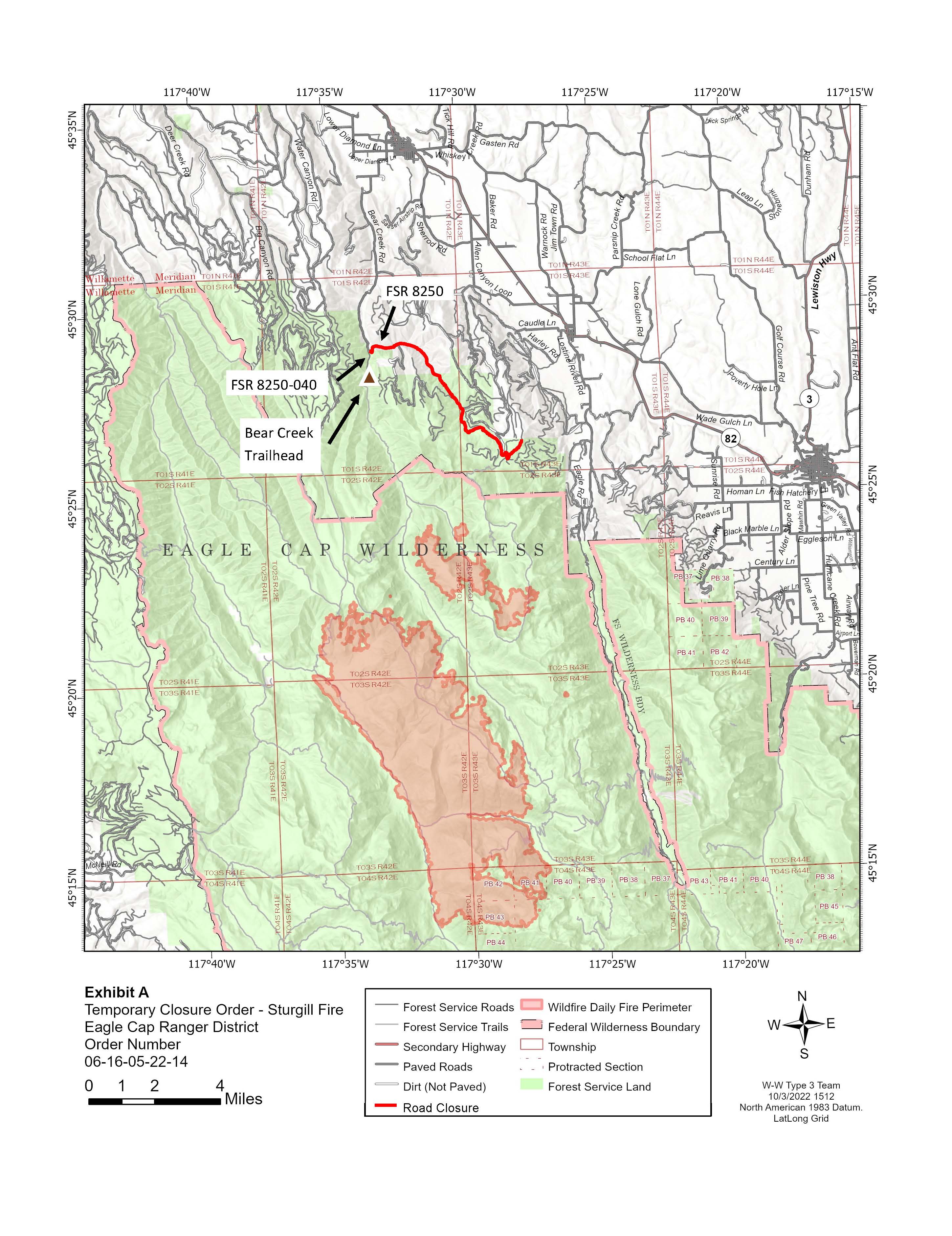
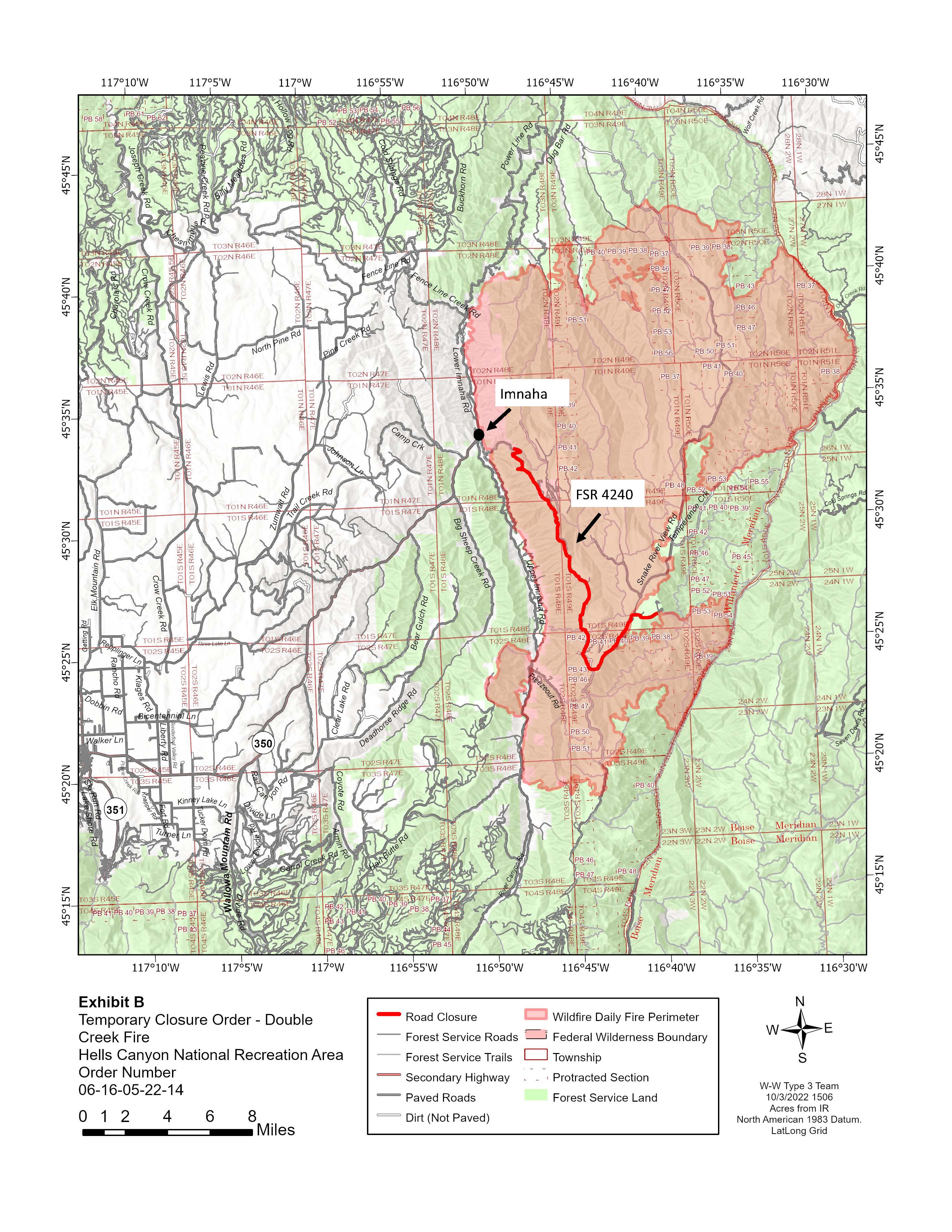
Wallowa-Whitman National Forest Temporary Road Closures: Closures are in effect for the Double Creek and Sturgill Fires due to operation of heavy equipment and log hauling. In the Double Creek Fire area the Hat Point Road is closed starting at the forest boundary. The Little Bear Creek Road (FSR 8250) is closed east to the junction with FSR 8250-040 near the Sturgill Fire.
Restrictions: Fire Restrictions are in place for the Wallowa-Whitman National Forest. Campfires should be in fire pits surrounded by dirt, rock, or commercial rings. Flammable material shall be cleared within a 3-foot radius and avoid overhanging limbs. Attend fires at all times and fully extinguish when not attended.
Information
Wallowa Mountains Office Office Hours: 8:00 AM – 4:30 PM Phone: 541-426-5546
Double Creek Fire
InciWeb
https://inciweb.nwcg.gov/incident/8366/
Facebook
www.facebook.com/doublecreekfire2022
Eagle Cap Wilderness Fires
Sturgill Fire InciWeb
https://inciweb.nwcg.gov/incident/8364/
Nebo Fire InciWeb
https://inciweb.nwcg.gov/incident/8363/
Goat Mountain 2 Fire InciWeb
https://inciweb.nwcg.gov/incident/8380/
Closure Update for the Double Creek Fire 10042022
Related Incident: Double Creek Fire
Publication Type: Closures
The remaining closure for the Double Creek Fire is the Hat Point Road starting at the forest boundary.
Updated Closure Maps for the Double Creek and Sturgill Fires
Related Incident: Double Creek Fire
Publication Type: Announcement
The following roads remain closed:
Double Creek Fire - Hat Point Rd
Sturgill Fire - FR 8250 (Little Bear Rd)
Double Creek Fire Update 10032021
Related Incident: Double Creek Fire
Publication Type: News
NOTICE: This update will be provided every 3 days and when significant changes occur.
Highlights: Weather continued to be cool and moist over the weekend with minimal drying on Sunday. Crews continued to survey areas of heat on the north end of the Double Creek and Sturgill Fires. Plans are in place to use bucket drops and crews to address hot spots as terrain and weather safely allows. Suppression repair is nearly complete and the size of the team will continue to shrink as those resources are released. The change in acreage is a combined result of active burning last week, and increased accuracy due to IR flights and ground/aerial surveys.
Double Creek Fire: 171,497 acres, increased 9,906 acres | 89% contained | 235 personnel assigned
Eagle Cap Wilderness Fires
Sturgill Fire: 21,621 acres, increased 112 acres | 80% of objectives achieved | 49 personnel assigned
Nebo Fire: 12,608 acres, increased 1 acre | 94% of objectives achieved | 0 personnel assigned
Goat Mountain 2 Fire: 584 acres, no change in acres | 0 personnel assigned
Weather: Gradual warming trend for the next several days will result in fuel moistures trending downward and expect a few smokes to develop today. As fuels continue to dry through the week, additional smokes are expected from fire areas that have remaining pockets of heat.
Wallowa-Whitman National Forest Temporary Area Closures: Closure orders are in effect for the Double Creek, Nebo, and Sturgill Fires. Closure Orders and Maps are available here. Roads within area closures and Forest Service Road (FSR) 8250 east to the junction with FSR 8250-040, FSR 3900-100, and FSR 3900-200 remain closed.
Road Closures: Upper Imnaha Road, Hat Point Road, Lower Imnaha Road, and Dug Bar Road are closed.
Fire Information
Double Creek Fire
Eagle Cap Wilderness Fires
Sturgill Fire InciWeb
Nebo Fire InciWeb
Goat Mountain 2 Fire InciWeb
###
Double Creek Fire Update 09302022
Related Incident: Double Creek Fire
Publication Type: News
Double Creek, Sturgill, Nebo, Goat Mountain Two Fire
Highlights: The Northeast Oregon Type 3 Team has assumed command of all fires from the Southern Area Blue Team. During the last 24 hours between a quarter inch to over an inch and a half of precipitation has fallen on the area. Cool, moist conditions are expected to remain through Saturday. Today crews will assess fires to determine what affect the rain had on remaining areas of heat. Suppression repair is nearly complete and those resources will be reassigned and the overall team size will drop as the Southern Area Blue Team departs.
Double Creek Fire: 161,591 acres, increased 81 acres | 89% contained | 436 personnel assigned
Eagle Cap Wilderness Fires
Sturgill Fire: 21,509 acres, increased 466 acres | 72% of objectives achieved | 60 personnel assigned
The fire area received wetting rain overnight and crews will survey the northern edge of the fire near Standley Guard Station and Red’s Horse Ranch. Monitoring will continue with little to no fire activity expected today.
This area will continue to be monitored today. Nearly a half inch of precipitation fell on the fire area and little to no fire activity is expected today.
Weather: Substantial precipitation occurred yesterday and overnight. Today will remain cloudy and cool with temperatures struggling to reach 60 degrees. Light rain is expected through the day. Relative humidity will stay above 60% today and tonight. Over the weekend, a very gradual warming and drying trend is expected.
Wallowa-Whitman National Forest Temporary Area Closures: Closure orders are in effect for the Double Creek, Nebo, and Sturgill Fires. Closure Orders and Maps are available here. Roads within area closures and Forest Service Road (FSR) 8250 east to the junction with FSR 8250-040, FSR 3900-100, and FSR 3900-200 remain closed.
Road Closures: Upper Imnaha Road, Hat Point Road, Lower Imnaha Road, and Dug Bar Road are closed.
Fire Information
Double Creek Fire
InciWeb
YouTube
Eagle Cap Wilderness Fires
Sturgill Fire
InciWeb
Nebo Fire
InciWeb
Goat Mountain 2 Fire
InciWeb
Double Creek Fire Update09292022
Related Incident: Double Creek Fire
Publication Type: News
September 29, 2022
Daily Update – 8:00 AM
Phone: 541-216-4579
Email: 2022.doublecreek@firenet.gov
Eagle Cap Wilderness Fires