
Trail Ridge Fire Update September 27 2022
Related Incident: Trail Ridge Fire
Publication Type: News
Start Date: 26AUG22
Cause: Lightning
Size: 17,157 acres
Type: 4/5
Completion: 65%
CURRENT STATUS
The Trail Ridge Fire is burning on the Wisdom District of the Beaverhead-Deerlodge National Forest as well as on the Darby-Sula District of the Bitterroot National Forest.
Incident Commander Zach Lee is currently reporting this fire to be 17,157 acres. An InfraRed acreage mapping mission has been requested and when that request is filled, acreage for this fire will be updated on InciWeb. You can find this incident on InciWeb at https://inciweb.nwcg.gov/incident/8365/
Recent warming and drying weather conditions resulted in more activity on this fire yesterday, resulting in visible smoke to the communities of Sula, as this fire burned in areas of green timber. This fire has not breached the containment lines nor Management Action Points established by Fire Personnel.
Fire Leadership and crews are working to address hot-spots on the fire, strengthening containment lines, and monitoring for any changes in fire behavior.
WEATHER AND FIRE BEHAVIOR
Continued warm and dry conditions are forecast for tomorrow, with a high of 80 and variable, light winds. It is expected that the fire will have similar fire behavior tomorrow.
CLOSURES AND SPECIAL MESSAGES
The most current Closure Order for the Trail Ridge Fire is effective as of 22SEP22 and can be viewed in full at https:// www.fs.usda.gov/alerts/bdnf/alerts-noticesTrail Ridge Fire Update Sept 23 2022
Related Incident: Trail Ridge Fire
Publication Type: News
Type 3 Management Organization
INCIDENT COMMANDER: Jay Wood
September 23, 2023
Trail Ridge Fire
Fire Summary
Approx. 5 miles SE Sula, MT
Approx. 11 miles NW of Big Hole National Battlefield
Size: 17,157 acres Completion: 60%
Personnel: 55
CURRENT STATUS
Yesterday’s fire activity was minimal fire growth mainly on the north flank of the fire in the 4B Drainage. Spread has slowed due to wet weather patterns. The fire perimeter is still within the indirect containment lines and crews are monitoring fire behavior in this area and continuing suppression repair efforts.
Crews continue to patrol and monitor fire behavior and minimize the potential for fire impact. Slash hauling is expected to conclude on Meadow Creek Road today.
Today’s weather, there will be a chance for some fog in the lower elevations of the fire. Winds turn westerly behind a departing trough of low pressure with a shift to northwesterly winds later in the day. Expect gusts to around 25 mph after noon. Winds will stay elevated on Saturday. The ridge will become established by Sunday. Temperatures will be warmer than normal through the middle of next week.
TRAIL RIDGE CLOSURES AND SPECIAL MESSAGES
The area closure has been rescinded and has been condensed to Meadow Creek Road, Mink Creek Road, and a portion of the Continental Divide Trail. See closure map.
Stage 2 Fire Restrictions are no longer in effect on all Bitterroot National Forest Lands
Specific closure information can be found at: https://inciweb.nwcg.gov/incident/8365
Public Information Officer Beaverhead-Deerlodge National Forest
(541) 350-4666 NEW PHONE Bitterroot National ForestTrail Ridge Fire Update Sept 21 2022
Related Incident: Trail Ridge Fire
Publication Type: News
Type 3 Management Organization
INCIDENT COMMANDER: Jay Wood
September 21, 2022
Trail Ridge Fire
Fire Summary
Approx. 5 miles SE Sula, MT
Approx. 11 miles NW of Big Hole National Battlefield
Size: 17,157 acres Completion: 50%
Personnel: 140
CURRENT STATUS
Yesterday’s fire activity was mainly on the north flank of the fire in the 4B Drainage but poses minimal concern. Spread is expected to slow down with the upcoming weather. The fire perimeter is still within the indirect containment lines and crews are monitoring fire behavior in this area, as well as continuing suppression repair efforts.
Crews are close to concluding chipping operations along the Mink and Meadow Creek roads near the 2017 Myers Fire Burn Area. On Forest Service Road 106 crews continue to monitor fire progression and minimize the potential for fire impact. Slash hauling will continue down the Meadow Creek Road.
FIRE WEATHER AND BEHAVIOR
East winds will be present near the fire on Wednesday, as wetting rains arrive from the south late in the afternoon. There will also be a brief window of thunderstorm chances Wednesday afternoon and evening. High chances of wetting rain Wednesday night through Thursday. Winds will shift to the southwest and become gusty on Thursday afternoon, with thunderstorms chances returning briefly. Daytime humidity will increase significantly from Wednesday to Thursday.
TRAIL RIDGE CLOSURES AND SPECIAL MESSAGES
Beaverhead-Deerlodge National Forest
• See the Fire Area Closure Order Map for Beaverhead-Deerlodge National Forest
Bitterroot National Forest
• See the Fire Area Closure Order Map for the Bitterroot National Forest
• Stage 2 Fire Restrictions are no longer in effect on all Bitterroot National Forest Lands
Specific closure information can be found at: https://inciweb.nwcg.gov/incident/8365
Public Information Officer Beaverhead-Deerlodge National Forest
(541) 350-4666 NEW PHONE Bitterroot National Forest
Trail Ridge Fire Update Sept 20 2022
Related Incident: Trail Ridge Fire
Publication Type: News
Sept. 20, 2022
Trail Ridge Fire
Fire Summary
Approx. 5 miles SE Sula, MT
Approx. 11 miles NW of Big Hole National Battlefield
Size: 17,157 acres Completion: 48%
Personnel: 162
Current Status
Yesterday the fire area experienced warm conditions in the morning followed by isolated thunderstorms with high winds in the late afternoon. Fire activity has been on the north flank of the fire and mainly in the 4B Drainage. The weather today will be sunny and moderate fire activity is expected again. The fire perimeter is still within the indirect containment lines and crews are monitoring fire behavior in this area as well as starting suppression repair efforts.
Crews will continue work along the Mink and Meadow Creek Roads, chipping brush from the indirect lines near the 2017 Myers fire burn area. On Forest Service Road 106, crews continue to monitor fire progression and minimize the potential for fire impact.
Transfer of command from CMT3, Shane Martin IC, to IMT3 Jay Wood IC took place Monday, September 19, 2022, at 1800.
FIRE WEATHER AND BEHAVIOR
Today will be mostly sunny with a slight chance fore precipitation over the fire area. The next chance for precipitation is forecasted for Wednesday through the end of the week with greater confidence of a wetting rain than previously predicted.
TRAIL RIDGE CLOSURES AND SPECIAL MESSAGES
Beaverhead-Deerlodge National Forest
- See the Fire Area Closure Map for the Beaverhead-Deerlodge National Forest
- See the Fire Area Closure for the Map for the Bitterroot National Forest
Trail Ridge Fire Update Sept 19 2022
Related Incident: Trail Ridge Fire
Publication Type: News
Trail Ridge Fire
Trail Ridge Fire Update Sept 18 2022
Related Incident: Trail Ridge Fire
Publication Type: News
Trail Ridge Fire
Fire Summary
Approx. 5 miles SE Sula, MT
Approx. 11 miles NW of Big Hole National Battlefield
Size: 17,084 acres Completion: 47%
Personnel: 158
CURRENT STATUS
Yesterday warm and sunny weather returned to the area causing an increase in visible smoke along the East Fork Road. The moisture received over the fire area during the last week has continued to help moderate fire behavior, but with the increased sun exposure and wind yester the fire did experience some movement within the 4B Creek Drainage. The fire perimeter is still within the indirect containment lines constructed and crews are monitoring fire behavior at this time. An IR flight was not available last night to record the change in acreage, but Fire Managers estimate about a 30 acre increase in this area. Fire Managers have been prepared for this uptick in activity and have plans and resources (Hotshot Crews, Helicopters, heavy equipment, etc.) in place in anticipation of increased fire behavior.
Crews continue to work along Meadow Creek Road on indirect line and road prep near the 2017 Myers Fire Burn Area. On Forest Service Road 106, crews continue with suppression repair work, crews are removing branches and small trees that were cut and moved when the fuel break was created using a chipper and other methods to disperse material and reduce the impacts of suppression work.
FIRE WEATHER AND BEHAVIOR
Today there is only a slight chance for isolated rain showers and thunderstorms in the afternoon. Tomorrow there is a greater chance for precipitation, accompanied by high winds with gusts up to 25 MPH. The chance for moisture will greatly increase later Wednesday or Thursday.
Beaverhead-Deerlodge National Forest
See the Fire Area Closure Order Map for the Beaverhead-Deerlodge National Forest
Bitterroot National Forest
See the Fire Area Closure Order Map for the Bitterroot National Forest
Stage 2 Fire Restrictions are in effect on all Bitterroot National Forest Lands
Trail Ridge Fire Update Sept 16 2022
Related Incident: Trail Ridge Fire
Publication Type: News
Trail Ridge Fire
Sturgill Fire Update 10062022
Related Incident: Sturgill Fire
Publication Type: News
Double Creek, Sturgill, Nebo, Goat Mountain Two Fires
###
Closure Update for the Sturgill Fire 10042022
Related Incident: Sturgill Fire
Publication Type: Closures
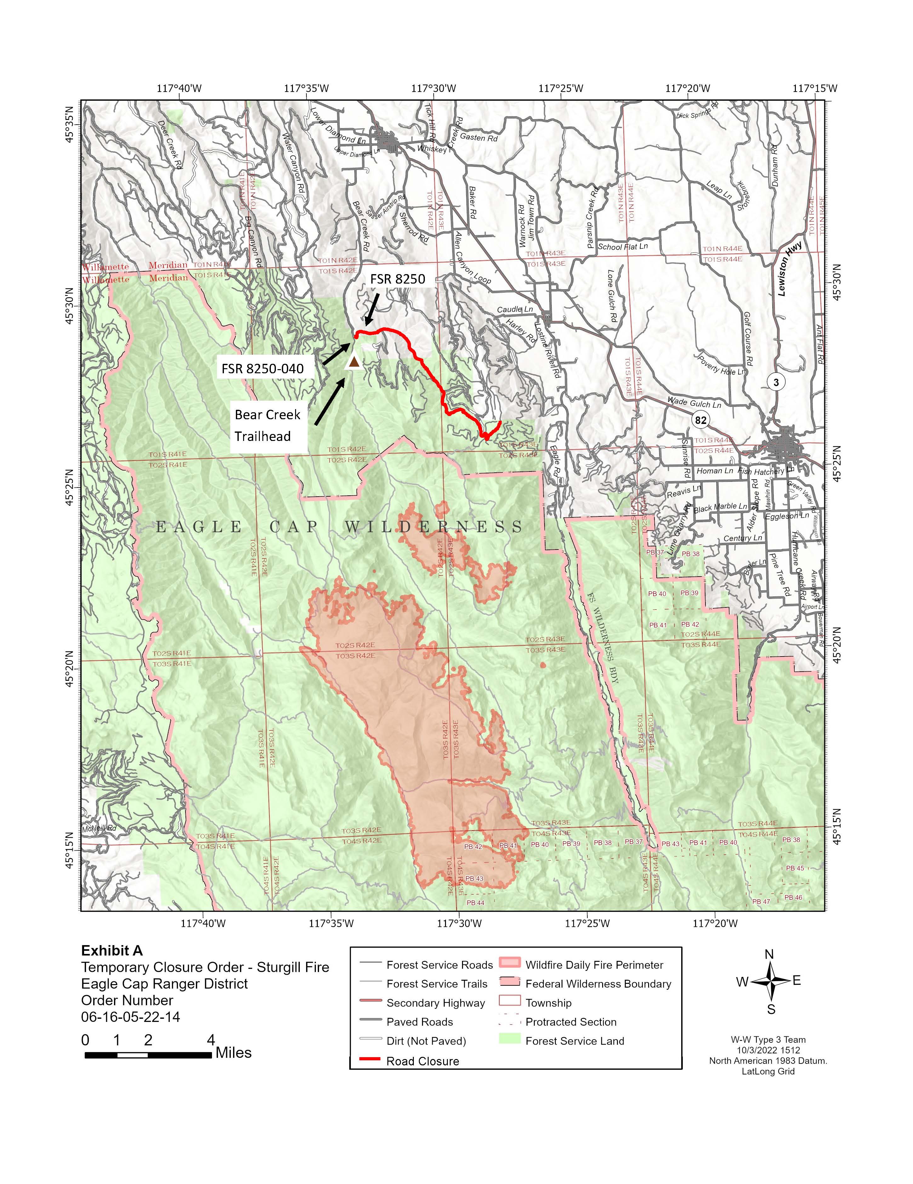
The Little Bear Rd (FS Road 8250) remains closed.
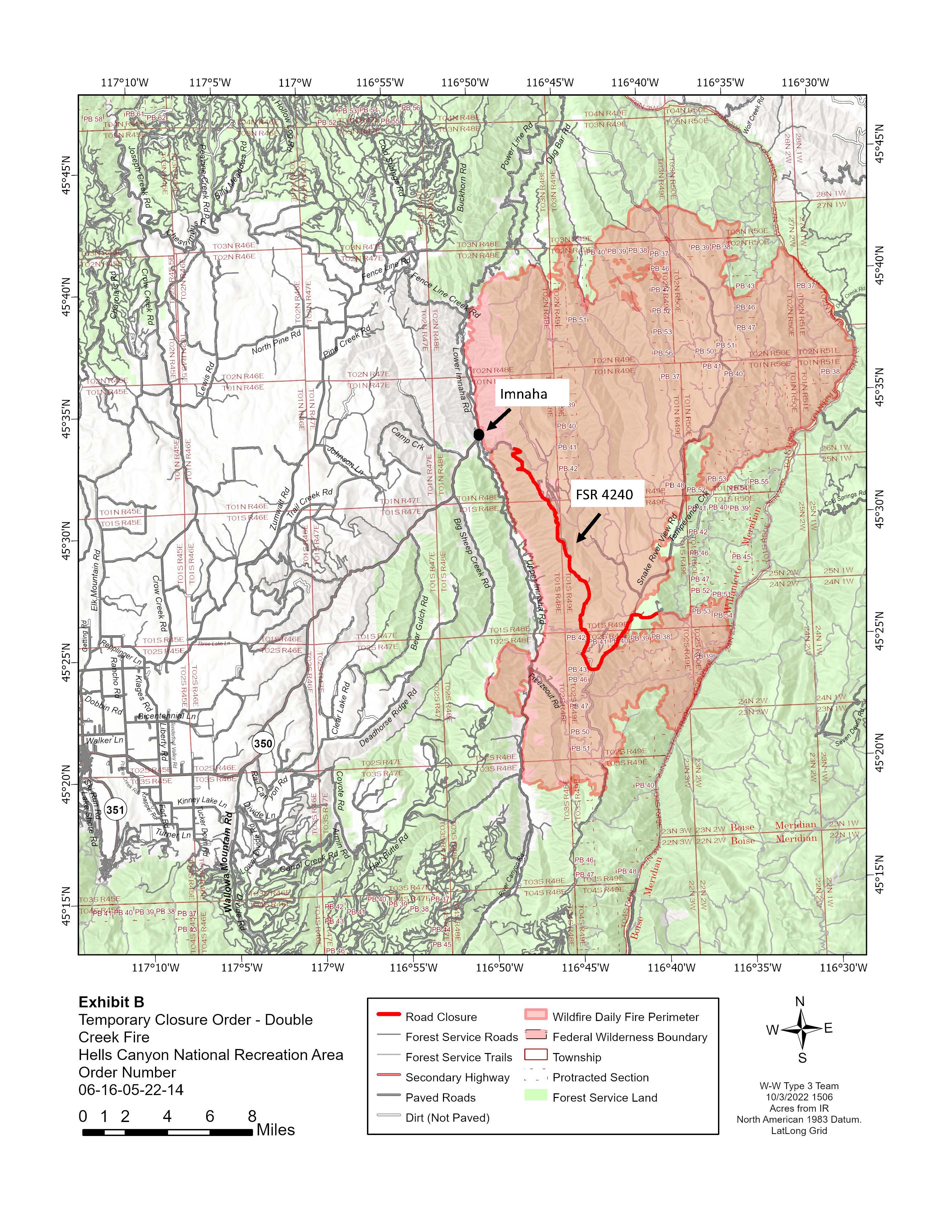
Updated Closure Maps for the Double Creek and Sturgill Fires 100422
Related Incident: Sturgill Fire
Publication Type: Announcement
The following roads remain closed:
Sturgill Fire: FR 8250 (Little Bear Rd.)
Double Creek Fire: Hat Point Rd.