
Ross Fork Fire Daily Update Monday September 19
Related Incident: Ross Fork
Publication Type: News
Ross Fork Fire Daily Update
September 19, 2022
Fire Information: Email: 2022.rossfork@firenet.gov
Phone: 208-329-6044 daily from 8 a.m. - 8 p.m.
Sawtooth National Forest Facebook: https://www.facebook.com/sawtoothnationalforest
YouTube:https://youtu.be/Ll7iJz55hnIInciweb: https://inciweb.nwcg.gov/incident/8375
Containment: 44%
Cause: Lightning
Acreage: 37,795 acres
Location: Sawtooth National Forest, Idaho
Fuel Type: Timber Litter/Timber/Short Grass
There continues to be some, but minimal fire activity over the last few days. The winds picked up in the area, but no new growth was noted. More winds are expected over the next few days because of a weather system off the Pacific Coast.
Cool, dry weather will continue the next few days. The fire is still active in some of the dry heavy fuels, with minimal spreading within the fire perimeter. Winds will be picking up and gusting up to about 40 mph in certain areas. There is a chance of measurable rain predicted over the fire area on Wednesday and Thursday. Temperatures will also cool off over the coming week.
Firefighters continue to patrol, mitigate hazards, and mop-up locations throughout. Crews will be evaluating the risks as the winds pick up today and proceed cautiously. The forest fire closure is still in effect to protect both firefighters and the public from harm. One of the biggest concerns is the possibility of new fires in the area due to the winds that are forecast. Be aware that Stage 1 Fire Restrictions are in effect. Please be safe to prevent any new starts.
Chipping and fireline repair work continues throughout the fire area and will continue for the next few days. A Burned Area Emergency Response (BAER) team is now at work in the area. BAER teams are resource specialists who determine the need for emergency treatments to prevent more costly damage to public lands, infrastructure, or natural and cultural resources.
This will be the final update from Great Basin Team 3. We thank the community for its support of the firefighters and the fire team. Sierra Nevada Team 3 will be “shadowing” today to receive all the information that they need to successfully assume command of the Ross Fork Fire on Tuesday, September 20 at 7:00 a.m.
STAGE 1 FIRE RESTRICTIONS: The US Forest Service and Idaho Department of Lands implemented fire restrictions for the Sawtooth North Zone. Check https://www.fs.usda.gov/alerts/sawtooth/alerts-notices for new updates.
CLOSURES AND RESTRICTIONS: The Sawtooth National Forest has reduced the area that is closed because of the Ross Fork Fire, effective Saturday, 9-17-22. All public lands east of Highway 75 are now open, as is Pettit Lake. Alturas Lake remains closed. The full closure language and map can be seen as pdf files at this link: https://inciweb.nwcg.gov/incident/article/8375/71996/
EVACUATIONS: All areas that had evacuation warnings have been reduced to “READY” status. Visit https://www.blainesheriff.com/152/Sheriff for more information. 98ew0 for more information.
TOTAL FIRE RESOURCES ASSIGNED
Personnel 462
Hand Crews 6
Engines 12
Helicopters 4
Visit our website at: www.fs.usda.gov/Sawtooth and on Facebook at: https://www.facebook.com/sawtoothnationalforest
Ross Fork Fire Daily Update Sunday September 18
Related Incident: Ross Fork
Publication Type: News
Ross Fork Fire Daily Update
September 18, 2022
Fire Information: Email: 2022.rossfork@firenet.gov
Phone: 208-329-6044 daily from 8 a.m. - 8 p.m.
Sawtooth National Forest Facebook: https://www.facebook.com/sawtoothnationalforest
YouTube:https://youtu.be/Ll7iJz55hnIInciweb: https://inciweb.nwcg.gov/incident/8375
Containment: 44%
Cause: Lightning
Acreage: 37,792 acres
Location: Sawtooth National Forest, Idaho
Fuel Type: Timber Litter/Timber/Short Grass
The Ross Fork Fire will continue downsizing resources today. As containment increases and fire behavior continues to be moderated by cool, wet weather, personnel and equipment will be released to assist with other wildfires. Helicopters will continue patrolling remote locations by air, as conditions allow. Structure protection measures will be evaluated by crews and if properties are no longer at risk, equipment will be broken down and prepared for use on other fires.
Forest closure orders have reduced in size and the public is allowed back into areas north of Cabin Creek and all public lands east of Highway 75, including Pole Creek. There will be extra traffic into and out of the area for the next few days and firefighters are still working along roadways, so please drive carefully.
Yesterday, brief rain, gusty winds and isolated hailstorms were reported on the fireline. A front coming into the area today will bring strong and gusty southern winds, mainly in the afternoon. Similar to Saturday, there is a chance of showers and thunderstorms in the afternoon. Fire-weakened trees are a constant threat to firefighters, and the public, in recently burned areas. Please stay out of closed areas.
Crews will continue to evaluate and eliminate hazardous trees and snags and complete chipping operations along road systems near the fire’s edge. In addition, a Burned Area Emergency Response (BAER) team is now at work. BAER teams are resource specialists who determine the need for emergency treatments to prevent more costly damage to public lands, infrastructure, or natural and cultural resources.
Near the Salmon River headwaters, the goal remains to keep the fire west of the Salmon River drainage. Yesterday, gusty winds prompted crews to withdraw from the edge of the fireline. They will return today and deepen containment lines if it is safe to do so.
Several areas, such as Jake's Gulch, still have burning hot spots and smoke will continue to be seen in those areas. Smoldering of heavy fuels, such as large logs and trees, will likely persist and finer fuels will continue to dry. Fire spread is possible in certain areas within the fire perimeter. Incident Commander Marty Adell reminds us, “this fire is not out yet.”
A new incident management team will take over the Ross Fork Fire on Tuesday, September 20 at 7:00 a.m.
STAGE 1 FIRE RESTRICTIONS: The US Forest Service and Idaho Department of Lands implemented fire restrictions for the Sawtooth North Zone. Check https://www.fs.usda.gov/alerts/sawtooth/alerts-notices for new updates.
EVACUATIONS: All areas that had evacuation warnings have been reduced to “READY” status. Any areas within the forest closure are not open to the public, unless private property can be accessed without using forest roads inside the closure. Visit https://www.blainesheriff.com/152/Sheriff for more information. 98ew0 for more information.
TOTAL FIRE RESOURCES ASSIGNED:
Personnel
507,
Hand Crews
13,
Engines
19,
Helicopters
4
Visit our website at: www.fs.usda.gov/Sawtooth and on Facebook at: https://www.facebook.com/sawtoothnationalforest
Ross Fork Fire Daily Update Saturday September 17
Related Incident: Ross Fork
Publication Type: News
Ross Fork Fire Daily Update
September 17, 2022
Fire Information: Email: 2022.rossfork@firenet.gov
Phone: 208-329-6044 daily from 8 a.m. - 8 p.m.
Sawtooth National Forest Facebook: https://www.facebook.com/sawtoothnationalforest
YouTube: https://youtu.be/Ll7iJz55hnI Inciweb: https://inciweb.nwcg.gov/incident/8375
Containment: 41%
Cause: Lightning
Acreage: 37,781 Acres
Location: Sawtooth National Forest, Idaho
Fuel Type: Timber Litter/Timber/Short Grass
The Sawtooth National Forest has reduced the closure for areas surrounding the #RossForkFire on the Sawtooth National Recreation Area and Fairfield Ranger District. Public lands and roads east of Highway 75 and north of Cabin Creek Road, including Pettit Lake, are now open, but Alturas Lake and other areas remain closed for firefighter and public safety. The order and a downloadable map are available on the fire’s Inciweb site at inciweb.nwcg.gov/incident/article/8375/71996/.
The fire is now considered 41% contained but many areas continue to smolder and firefighters are still working along many roads. For your own safety and the safety of fire crews, please stay out of those areas that remain closed.
Scattered showers brought precipitation to the Ross Fork fire yesterday. This moisture makes flashy fuels such as grasses and pine needles less susceptible to burning. Heavier fuels—large logs and trees—will continue to burn as they are less influenced by changes in humidity. Despite recent rains, the forest is at a record-low fuel moisture level for this time of the year. Smoldering fuels may re-ignite if fuels dry out sufficiently. Although the forest closure has reduced in size, areas burned by wildfire are dangerous. Hazardous conditions in burned over areas may involve weakened and falling trees and limbs, hidden stump holes, loose rock, and hot smoldering ground. If you plan to visit the forest this weekend, ensure your own safety and protection by staying clear of locations that have burned over.
An aerial reconnaissance was conducted yesterday and several intense heat sources continue to be detected in Jake’s Gulch, Vienna Creek, the West Fork of the Big Smoky Creek, Frenchman Creek, and near the headwaters of the Salmon River. All active heat sources were within the fire perimeter. Smoke will be seen in areas where the fire is still active.
Crews will continue to mop up, conduct chipping operations, and patrol the fire area. As traffic and visitation increases over the weekend, be cautious around firefighters and crews as they continue to perform essential duties along Highway 75 and forest roadways. Highway 75 remains open.
An improperly disposed of campfire was reported and discovered 8 miles northwest of Ketchum. A local engine assigned to the Ross Fork Fire responded to the Lower Baker Fire and it is contained and out. Please review fire restrictions and ensure all campfires are completely extinguished after use. Firefighters also responded to a second fire yesterday in the Wood River Valley near Ohio Gulch. Check https://www.facebook.com/woodriverfirerescue for more information.
STAGE 1 FIRE RESTRICTIONS: The US Forest Service and Idaho Department of Lands implemented fire restrictions for the Sawtooth North Zone. Visit https://www.fs.usda.gov/alerts/sawtooth/alerts-notices for updates.
EVACUATIONS: All areas that had evacuation areas have been reduced to “READY” status. Any areas within the forest closure are not open to the public, unless private property can be accessed without using forest roads inside the closure. Visit https://www.blainesheriff.com/152/Sheriff for more information. 98ew0
TOTAL FIRE RESOURCES ASSIGNED:
Personnel
592,
Hand Crews
14,
Engines
22,
Helicopters
4
Visit our website at: www.fs.usda.gov/Sawtooth and on Facebook at: https://www.facebook.com/sawtoothnationalforest
Sawtooth National Forest Reduced Closure Area Saturday 917
Related Incident: Ross Fork
Publication Type: Closures
The Sawtooth National Forest has reduced the area that is closed because of the Ross Fork Fire, effective Saturday, 9-17-22. All public lands east of Highway 75 are now open, as is Pettit Lake. Alturas Lake remains closed. The fire is still smoldering in many areas and can become active again as things dry out. Many hazards remain in the recently burned areas. Please recreate responsibly. See the map and the closure language at the links below or under the maps tab of this site.
Final InciWeb Update
Related Incident: Williams Creek Fire
Publication Type: Announcement
The Williams Creek and Twin Lakes fires have recently shown no significant fire activity. This InciWeb page will no longer be updated unless an unexpected increase in activity occurs. For continued Nez Perce-Clearwater National Forests wildfire information updates, please visit http://bit.ly/NPCFireInfo.
Closure Orders RESCINDED
Related Incident: Williams Creek Fire
Publication Type: Announcement
Closure orders previously in place for the Williams Creek and Twin Lakes fires have been rescinded. For the latest Nez Perce-Clearwater National Forests closure information, please visit https://bit.ly/NPClwNF-AlertsNotices or call the forest’s fire information line at 208-935-6134.
Solomon Fire Update Sept 19 2022
Related Incident: Solomon Fire
Publication Type: News
Fire Update: Solomon Fire, Welcome Creek Wilderness - Sept. 19, 2022
Recent precipitation and cool weather has minimized fire behavior and the fire is now being managed under a Type 5 Incident Command Structure. The fire will continue to smolder and light smoke may be visible until a season-ending event occurs which is either substantial rain or snowfall. Over the next few weeks, smoke may be visible from the Rock Creek Road and the Rock Creek recreation corridor on warm and dry days. Trail closures remain in place for public safety. Firefighters will continue to patrol the fire from the Rock Creek corridor.
Information boards are still available at:
- Rock Creek Fisherman’s Mercantile
- The Clinton Market
- Rock Creek Trout Bums
All closures rescinded
Related Incident: Columbus Fire
Publication Type: Closures
All closures associated with the Columbus Fire have been rescinded. This includes closures in place on the Idaho Panhandle and Kootenai National Forests. Although closures have been lifted, additional hazards are present in burned areas.
-Watch for falling trees. Even if the tree looks robust, it might be at risk of falling because of damaged root systems and fire-loosened soils. As the years pass, dead root systems rot and the likelihood of the tree falling increases. Watch for falling branches as well. Look up often. Take note of fire-weakened trees, snags and overhead dangling branches. Do not sit down and take a break under a fire-weakened or dead tree.-Windy days are especially dangerous. Don’t go out in a burn area if it’s forecast to be windy. Leave the area immediately if the wind picks up and there are hazards around you. Don’t make camp below burned trees.-Rainy weather is also dangerous. Wind often accompanies rain. And even if it’s just rainy, the chances of landslides and flash floods goes up. Water runs more quickly off the burned soil. And drainages can become clogged with trees, rocks, and debris. Debris can act like a dam, releasing a flash flood of water, mud, and debris.-Travel through burn areas quickly. Minimize the risk you face by not lingering in dangerous places.-Be extra cautious when choosing a campsite. Don’t camp in a risky area. Look for dead trees that might fall toward your tent and steep slopes that could send rocks or landslides down on you. Don’t camp in natural swales or drainages because of debris flows.-Landslides and rock fall danger means you should be careful on hillsides. Stripped of its understory vegetation, burned soil is loose, so boulders, logs, and the soil can move. These dangers can increase as the freeze-thaw cycle loosens things up. On hillsides, if you encounter a downed log or pile of fallen rocks, go one person at a time in case the material shifts.-Signs may have burned meaning you’re on your own when navigating. Bring maps and pay attention. The trail tread might be unstable, and it may collapse. Debris fallen from uphill can take out the trail tread.-Watch for burned-out holes in the ground. When stumps, root structures and duff burns, deep hollow cavities can be left below the trail surface. They may be invisible until your foot breaks through. These holes can keep burning for months after the rest of the fire is out. Notice white ash as it may be retaining extreme heat or be a sign of a potential sinkhole. Stay on trails in burned areas. Be extra cautious when leaving the trail, especially at night.-Watch for higher than normal stream flow, especially as the snow melts. Burned areas may melt snow more quickly, resulting in higher than normal flows where the trail crosses a stream.
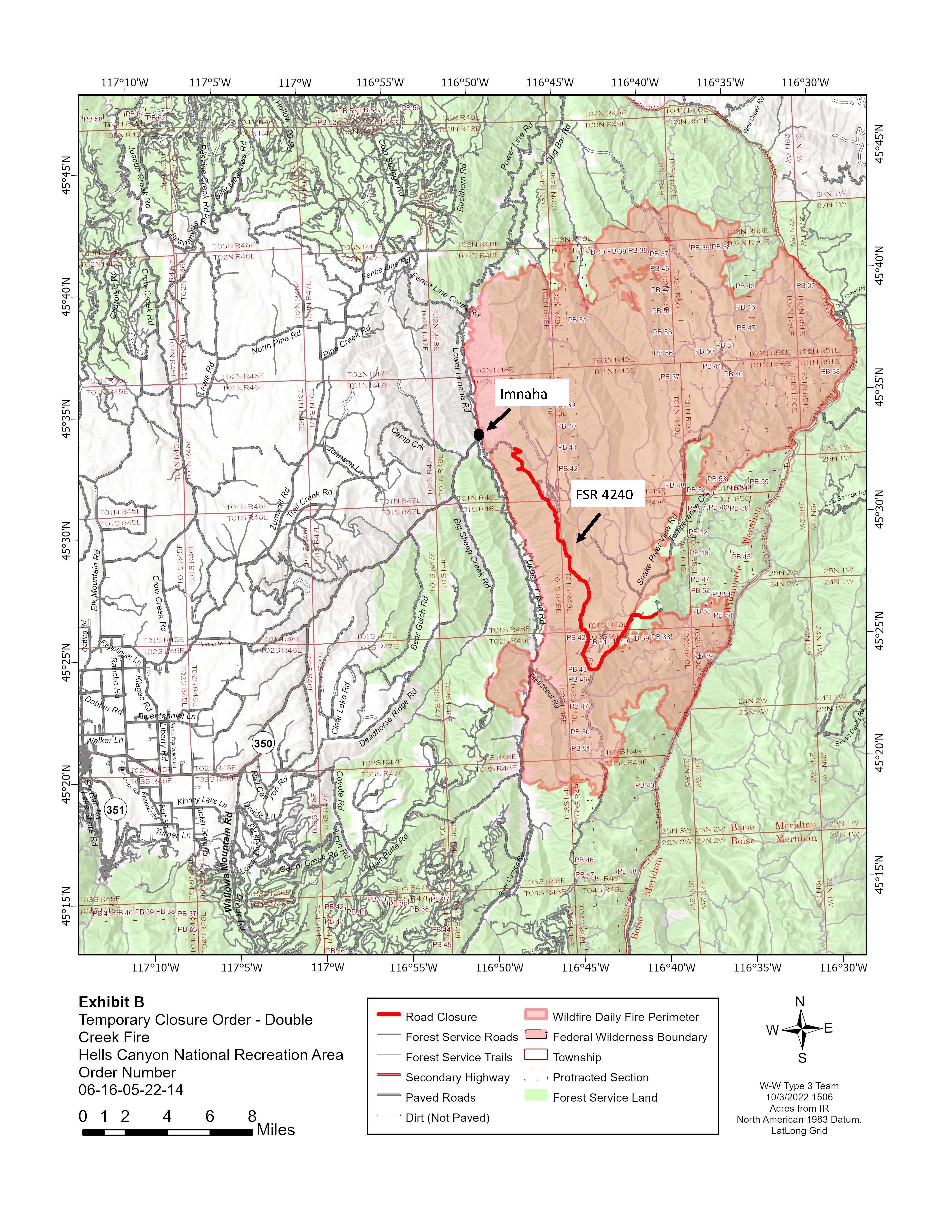
Double Creek Fire Update 10062022
Related Incident: Double Creek Fire
Publication Type: News
Double Creek, Sturgill, Nebo, Goat Mountain Two Fires
Thursday October 6, 2022
Update – 8:00 AM Northeast Oregon Type 3 Team
NOTICE: This will be the last update from the incident team.
Highlights: Weather has gradually warmed and become drier each day after the cool and moist conditions last weekend. Very little change in fire behavior and spread has been observed despite the warmer and drier conditions. Fire crews will continue to monitor the north end of the Double Creek and Sturgill Fires for hot spots and use aerial bucket drops when terrain and weather safely allow. The Type 3 team will transition to two Type 4 Teams on Friday, 10/7.
Double Creek Fire: 171,530 acres, increased 33 acres | 89% contained | 155 personnel assigned
Isolated areas of heat remain in the Cow Creek, Deep Creek, and Lightning Creek drainages on steep and inaccessible terrain. Little growth is expected and the area will be monitored with aerial resources.
Eagle Cap Wilderness Fires
Sturgill Fire: 21,710 acres, increased 99 acres | 80% of objectives achieved | 60 personnel assigned
A fire crew is monitoring the northern edge today and minimal fire activity is expected.
Nebo Fire: 12,609 acres, increased 1 acre | 94% of objectives achieved | 0 personnel assigned
Goat Mountain 2 Fire: 584 acres, no change in acres | 0 personnel assigned
Aerial monitoring will continue but little to no fire activity is expected for the Nebo and Goat Mountain 2 Fires.
Weather: Warmer than normal temperatures and dry conditions will persist through the weekend with fuel moistures continuing to gradually trend downward. Early next week another storm system will impact the area with increasing winds Monday and cooler conditions mid-week with the potential for precipitation.
Wallowa-Whitman National Forest Temporary Road Closures: Closures are in effect for the Double Creek and Sturgill Fires due to operation of heavy equipment and log hauling. In the Double Creek Fire area the Hat Point Road is closed starting at the forest boundary. The Little Bear Creek Road (FSR 8250) is closed east to the junction with FSR 8250-040 near the Sturgill Fire.
Restrictions: Fire Restrictions are in place for the Wallowa-Whitman National Forest. Campfires should be in fire pits surrounded by dirt, rock, or commercial rings. Flammable material shall be cleared within a 3-foot radius and avoid overhanging limbs. Attend fires at all times and fully extinguish when not attended.
Information
Wallowa Mountains Office Office Hours: 8:00 AM – 4:30 PM Phone: 541-426-5546
Double Creek Fire
InciWeb
https://inciweb.nwcg.gov/incident/8366/
Facebook
www.facebook.com/doublecreekfire2022
Eagle Cap Wilderness Fires
Sturgill Fire InciWeb
https://inciweb.nwcg.gov/incident/8364/
Nebo Fire InciWeb
https://inciweb.nwcg.gov/incident/8363/
Goat Mountain 2 Fire InciWeb
https://inciweb.nwcg.gov/incident/8380/
Closure Update for the Double Creek Fire 10042022
Related Incident: Double Creek Fire
Publication Type: Closures
The remaining closure for the Double Creek Fire is the Hat Point Road starting at the forest boundary.