
Fire Restrictions Lifted and Fire Danger Lowered
Related Incident: Mill Lake Fire
Publication Type: News
Hamilton, MT, September 19, 2022
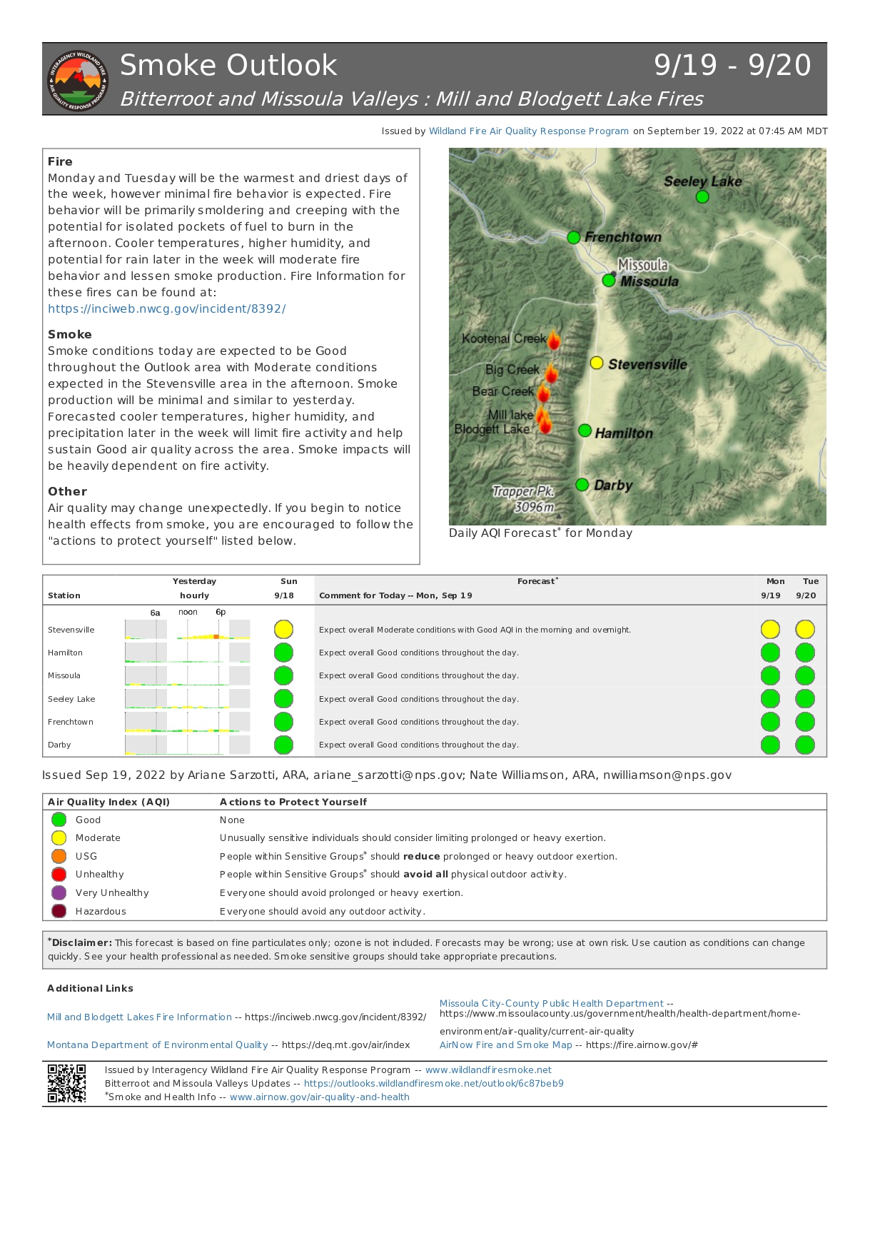
Many locations across the forest received precipitation within the last week with totals ranging from a ¼ inch to nearly 1 inch. Temperatures this week will remain near normal, and a southwest flow will develop that is forecast to bring additional chances of precipitation Wednesday night and Thursday along with potential thunderstorms.
The Magruder Road Corridor between Darby MT. and Elk City, ID. is now open after the Forest lifted the road closure last week from the Twist Creek Fire. The Hog Trough Fire area closure up Skalkaho on the Darby Ranger District was also lifted this weekend. Please note, the Indian Ridge Fire area closure on the West Fork Ranger District remains in place https://inciweb.nwcg.gov/incident/8319/
While fire danger has lessened, fire season is not over. Although campfires can be one of the best parts of camping and provide necessary warmth to hunters and other outdoor enthusiasts, they can also spark wildfires. Please don’t forget your responsibility to maintain and extinguish all campfires. Remember, if it’s too hot to touch, it’s too hot to leave. Never leave a campfire unattended.
USDA is an equal opportunity provider, employer and lender.
Public Affairs Officer
Forest Service
Bitterroot National Forest
p: 406-363-7122
c: 406-531-1130
tod.mckay@usda.gov
1801 North 1st Street
Hamilton, MT 59840
www.fs.fed.us
Caring for the land and serving people
Blodgett Lake Mill Lake Fires Update Sept 19 2022
Related Incident: Mill Lake Fire
Publication Type: News
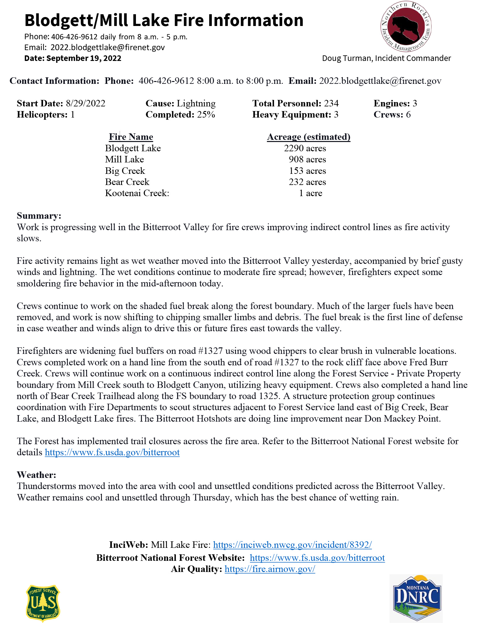
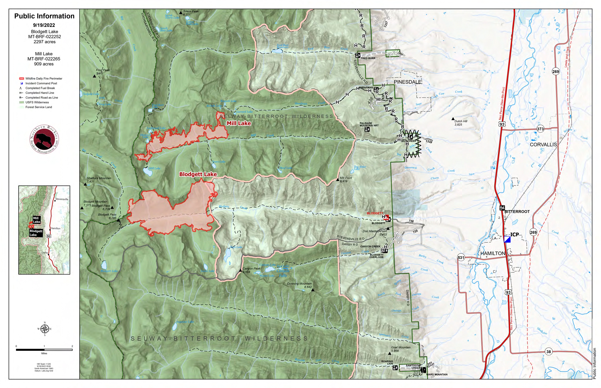
Blodgett Lake 2290 acres
Big Creek 153 acres
Bear Creek 232 acres
Kootenai Creek: 1 acre
Summary:
Work is progressing well in the Bitterroot Valley for fire crews improving indirect control lines as fire activity slows.
Fire activity remains light as wet weather moved into the Bitterroot Valley yesterday, accompanied by brief gusty winds and lightning. The wet conditions continue to moderate fire spread; however, firefighters expect some smoldering fire behavior in the mid-afternoon today.
Crews continue to work on the shaded fuel break along the forest boundary. Much of the larger fuels have been removed, and work is now shifting to chipping smaller limbs and debris. The fuel break is the first line of defense in case weather and winds align to drive this or future fires east towards the valley.
Firefighters are widening fuel buffers on road #1327 using wood chippers to clear brush in vulnerable locations. Crews completed work on a hand line from the south end of road #1327 to the rock cliff face above Fred Burr Creek. Crews will continue work on a continuous indirect control line along the Forest Service - Private Property boundary from Mill Creek south to Blodgett Canyon, utilizing heavy equipment. Crews also completed a hand line north of Bear Creek Trailhead along the FS boundary to road 1325. A structure protection group continues coordination with Fire Departments to scout structures adjacent to Forest Service land east of Big Creek, Bear Lake, and Blodgett Lake fires. The Bitterroot Hotshots are doing line improvement near Don Mackey Point.The Forest has implemented trail closures across the fire area. Refer to the Bitterroot National Forest website for details https://www.fs.usda.gov/bitterroot
Weather:
Thunderstorms moved into the area with cool and unsettled conditions predicted across the Bitterroot Valley. Weather remains cool and unsettled through Thursday, which has the best chance of a wetting rain.
InciWeb: Mill Lake Fire: https://inciweb.nwcg.gov/incident/8392/
Bitterroot National Forest Website: https://www.fs.usda.gov/bitterroot
Air Quality: https://fire.airnow.gov/
Mill Lake Blodgett Lake Fire Update for Sept 18 2022
Related Incident: Mill Lake Fire
Publication Type: News
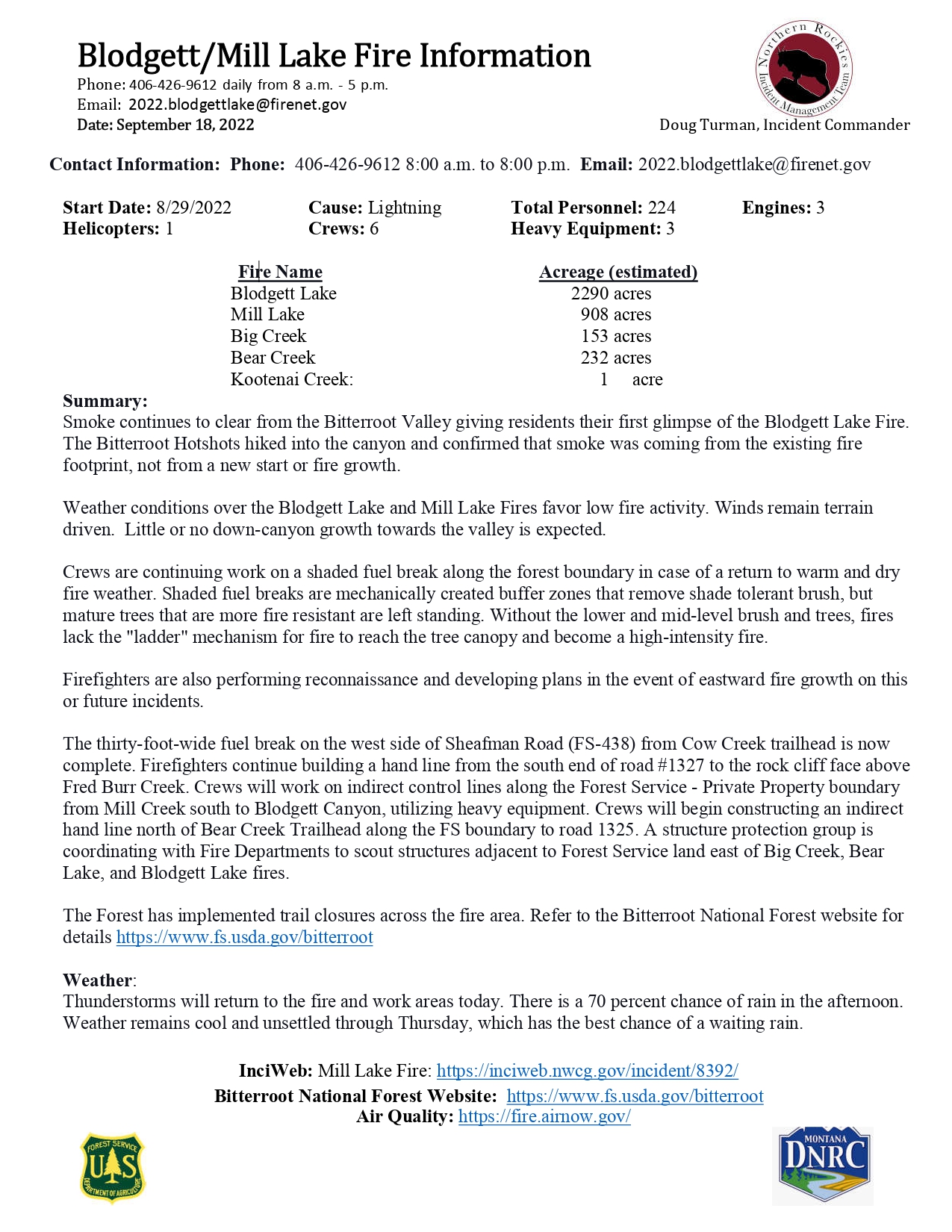
Fire Name Acreage (estimated)
Blodgett Lake 2290 acres
Mill 908 acres
Kootenai Creek: 1 acre
Summary:
Smoke continues to clear from the Bitterroot Valley giving residents their first glimpse of the Blodgett Lake Fire. The Bitterroot Hotshots hiked into the canyon and confirmed that smoke was coming from the existing fire footprint, not from a new start or fire growth.
Weather conditions over the Blodgett Lake and Mill Lake Fires favor low fire activity. Winds remain terrain driven. Little or no down-canyon growth towards the valley is expected.
Crews are continuing work on a shaded fuel break along the forest boundary in case of a return to warm and dry fire weather. Shaded fuel breaks are mechanically created buffer zones that remove shade tolerant brush, but mature trees that are more fire resistant are left standing. Without the lower and mid-level brush and trees, fires lack the "ladder" mechanism for fire to reach the tree canopy and become a high-intensity fire.
Firefighters are also performing reconnaissance and developing plans in the event of eastward fire growth on this or future incidents.
The thirty-foot-wide fuel break on the west side of Sheafman Road (FS-438) from Cow Creek trailhead is now complete. Firefighters continue building a hand line from the south end of road #1327 to the rock cliff face above Fred Burr Creek. Crews will work on indirect control lines along the Forest Service - Private Property boundary from Mill Creek south to Blodgett Canyon, utilizing heavy equipment. Crews will begin constructing an indirect hand line north of Bear Creek Trailhead along the FS boundary to road 1325. A structure protection group is coordinating with Fire Departments to scout structures adjacent to Forest Service land east of Big Creek, Bear Lake, and Blodgett Lake fires.
The Forest has implemented trail closures across the fire area. Refer to the Bitterroot National Forest website for details https://www.fs.usda.gov/bitterroot
Weather:
Thunderstorms will return to the fire and work areas today. There is a 70 percent chance of rain in the afternoon. Weather remains cool and unsettled through Thursday, which has the best chance of a waiting rain.
InciWeb: Mill Lake Fire: https://inciweb.nwcg.gov/incident/8392/
Bitterroot National Forest Website: https://www.fs.usda.gov/bitterroot
Air Quality: https://fire.airnow.gov/
Mill Lake and Blodgett Lake Fire Update for September 17 2022
Related Incident: Mill Lake Fire
Publication Type: News
Blodgett Lake 2270 acres
Big Creek 150 acres
Bear Creek 229 acres
Kootenai Creek: 1 acres
Summary:
Recent winds improved air quality and allowed the use of aviation resources for aerial reconnaissance. As reported yesterday, these flights revealed that the fires had not grown eastward down the canyons since Monday, September 12. More accurate mapping from these flights have resulted in a decrease in the estimated Mill Lake fire size.
Northern Rockies Team One has responsibility for the five fires listed above. Today, crews will scout the area and continue line preparation, and fire managers will work on a long-term plan for this incident. This planning effort will include fuel removal and alternate line locations between Blodgett and Kootenai canyons.
Work continues on roads and trails being prepped as a control line to keep the fire west of road #430. Crews continued constructing a thirty-foot-wide fuel break on the west side of Sheafman Road (FS-438) from Cow Creek trailhead to Sheafman trailhead. Firefighters are building a hand line from the south end of road #1327 to the rock cliff face above Fred Burr Creek. Crews will work on indirect control lines along the Forest Service - Private Property boundary from Mill Creek south to Blodgett Canyon, utilizing heavy equipment. Firefighters are scouting strategic line locations and control features that could slow the fire's spread east towards private and DNRC lands. Crews will begin constructing an indirect hand line north of Bear Creek Trailhead along the FS boundary to road 1325. A structure protection group will coordinate with Fire Departments to scout structures adjacent to Forest Service land east of Big Creek, Bear Lake, and Blodgett Lake fires.
The Blodgett Fire is now estimated at 2270 acres. The fire has crossed Blodgett Creek along the east flank and is smoldering in down and dead fuels. Recent moisture and cooler temperatures should result in limited fire behavior today. The Forest has implemented additional trail closures across the fire area. Refer to the Bitterroot National Forest website for details https://www.fs.usda.gov/bitterroot
Weather:
Today will be another cool day with maximum temperatures reaching into the low 60s with a slight chance of showers late afternoon. Compared to recent days, there will be more sunshine. Winds will be light (west to east at 10 mph) influenced by the terrain (elevation & slope).
InciWeb: Mill Lake Fire: https://inciweb.nwcg.gov/incident/8392/
Bitterroot National Forest Website: https://www.fs.usda.gov/bitterroot
Boulder Mountain Fire update for Monday Sept 26
Related Incident: Boulder Mountain Fire
Publication Type: News
CUSICK, Wash. – Firefighters have suppressed the Boulder Mountain Fire to 99% containment and have kept the fire footprint as small as possible.
- Dead or dying trees that remain standing after a wildfire are unstable, especially in high winds.
- Burned out stumps and root systems can create pits that may also be camouflaged by ash or debris. They can also weaken the soil, making it subject to collapse. Stepping or falling into one could break a bone. They may also contain hot embers that can cause severe burns.
- Ash and fallen needles are slippery and can make for treacherous footing on trails.
- Unstable soils and areas stripped of vegetation can result in falling rocks or logs and landslides in dry weather, or debris flows and flash floods in rainy weather.
Boulder Mountain Fire update for Sunday Sept 25
Related Incident: Boulder Mountain Fire
Publication Type: News
Boulder Mountain Fire update for Saturday Sept 24
Related Incident: Boulder Mountain Fire
Publication Type: News
Boulder Mountain Fire update for Friday Sept 23
Related Incident: Boulder Mountain Fire
Publication Type: News
Safety: Safety of firefighters and members of the public are our first priority. All hunters are encouraged to become familiarized with the USFS closure area, don personal protective equipment and practice safe hunting practices as forest grouse season gets under way.
Closures: An area closure remains in place for the Boulder Mountain Fire on the Colville National Forest. For a map and complete description of the closure area, including a list of trails and roads, go to https://www.fs.usda.gov/alerts/colville/alerts-notices.
Boulder Mountain Fire update for Thursday Sept 22
Related Incident: Boulder Mountain Fire
Publication Type: News
Boulder Mountain Fire
Boulder Mountain Fire update for Wednesday Sept 21
Related Incident: Boulder Mountain Fire
Publication Type: News
CUSICK, Wash. – Work on the fire is progressing rapidly, with large sections of containment line nearing completion and other areas shifting to patrol and monitor status.
Safety: Safety of firefighters and members of the public are our first priority. All hunters are encouraged to become familiarized with the USFS closure area, don personal protective equipment and practice safe hunting practices as forest grouse season gets under way.
Closures: An area closure remains in place for the Boulder Mountain Fire on the Colville National Forest. For a map and complete description of the closure area, including a list of trails and roads, go to https://www.fs.usda.gov/alerts/colville/alerts-notices.