
Evacuation Change Downgrade for Georgetown El Dorado County 091622
Related Incident: Mosquito Fire
Publication Type: Announcement
EVACUATION UPDATE: Evacuation Orders Downgraded to Warnings for Portions of Georgetown
MOSQUITO FIRE – EVACUATION UPDATE
RELEASE DATE: 09/16/2022 TIME: 4:00 p.m.
EVACUATION ORDER LIFTED
Area Name: Portions of Georgetown
Per the El Dorado Sheriff’s Office: Effective immediately, portions of Georgetown have been changed to an Evacuation Warning status and repopulation of this area may now occur:
- The area west of Wentworth Springs Road at Citabria Lane
North of Greenwood Road and Graybar Mine Road East of Highway 193 at Sliger Mine Road South of Bottle Hill Road and Snow Cap Road This does not include Sliger Mine Road north of Loriel Drive and Spanish Dry Diggins Road north of Odyssey Falls Drive.
Traffic Control Points:
- Spanish Dry Diggins Road/Reservoir Road
- Sliger Mine Road/North of Loriel Drive
- Wentworth Springs Road/Citabria Road
View current El Dorado County evacuation orders and warnings on the interactive map: bit.ly/3ATtqao
El Dorado County dashboard for Mosquito Fire information: edcgov.us/mosquito-fire-information
SAFETY MESSAGE
Please be safe when returning home. Be aware of your surroundings as fire and emergency work continue within the county. Also, remember that this is still considered an Evacuation Warning area. This means that there is still threat of fire danger and you should remain prepared to evacuate if the need arises. Those who require extra time to evacuate should remain out of the area. As you re-enter your property and evaluate damage, be aware that hazardous conditions may still exist. For more information on returning home from a wildfire, visit www.ReadyforWildfire.org.
NW Pasayten Wilderness Fires Closure Order superseding CO 0617042217
Related Incident: NW Pasayten Complex
Publication Type: Closures
NW Pasayten Wilderness Fires Closure
Closure Order: 06-17-04-22-17
Pursuant to 16 USC § 551 and 36 CFR § 261.50(a) and (b), and to provide for public safety, the following acts are prohibited within the Methow Valley Ranger District of the Okanogan-Wenatchee National Forest. This Order supersedes Order # 06-17-04-22-15 dated September 9,2022, signed by Kristin Bail. This Order is effective September 23, 2022, through November 30,2022, unless rescinded sooner.
PROHIBITIONS:
1. Entering into or being upon National Forest System lands, as described below and displayed on the attached map, Exhibit A [36 CFR § 261.53(e)].
2. Being on a National Forest System trail, as described below and displayed on the attached map, Exhibit A [36 CFR § 261.55(a)].
CLOSURE AREA DESCRIPTION:
The Fire Emergency Area Closure is defined as follows:
The fire closure area boundary begins at the junction of the U.S. – Canada border and the administrative boundary with Ross Lake National Recreation Area (NRA) in northwest corner of T. 41 N., R. 14 E., sec. 32. The closure boundary follows the NRA boundary south to where it crosses Trail #749 in T. 40 N., R. 14 E., sec. 3. From this point, the closure follows and includes Trail #749 to the east to the point where Trail #749 crosses the boundary between Okanogan County and Whatcom County in the southwest corner of T. 40 N., R. 16 E., sec. 23. The closure then proceeds north along the county border to its intersection with the U.S. - Canada border in T. 41 N., R. 16 E., sec. 39, then west along the U.S. - Canada border until reaching the point of origin in northwest corner of T. 41 N., R. 14 E., sec. 38.
The following trails are included in this closure order:
Trails Closed:
• Trail #454 Monument 83
• Trail #461 Border
• Trail #471 Point Defiance
• Trail #472 West Fork Pasayten
• Trail #472.1 Holman Creek
• Trail #473 Rock Creek
• Trail #474 Eureka Creek from its junction with Trail #478 Robinson Creek to its junction with Trail #484 Monument Creek
• Trail #477 Hidden Lakes from its junction with Trail #485 Tatoosh Buttes to its junction with Trail #533 Boundary Trail
• Trail #478 Robinson Creek from its junction with Trail #474 Ferguson Lake to its junction with Trail #533 Boundary Trail
• Trail #482 Chuchuwanteen
• Trail #484 Monument Creek from its junction with Trail #474 Eureka Creek east to Shellrock Pass
• Trail #485 Tatoosh Buttes
• Trail #490 Heather Lake
• Trail #495 The Parks
• Trail #498 Buckskin Ridge from Silver Creek north to its junction with Trail # 478 Robinson Creek
• Trail #533 Boundary from its intersection with Trail #456 Dean Creek to its junction with the Pacific Crest Trail #2000
• Trail #576 Buffalo Pass
• Trail #749 Castle Pass from the boundary of North Cascades National Park in T40N R14E S3 to its eastern terminus at Pacific Crest Trail #2000 in T40N R16E S19.
• Trail #752 Devils Ridge from its junction with Trail #738 Jackita Ridge to its junction with Pacific Crest Trail #2000.
• Trail #752.1 Dry Creek Pass
Trail #754 Canyon Creek from the confluence of Slate Creek and Canyon Creek to its junction with Trail #752 Devils Ridge
• Trail #2000 Pacific Crest Trail from Windy Pass to its northern terminus at the U.S. – Canada border.
See Exhibit A for closure map.
EXEMPTIONS:
Pursuant to 36 CFR § 261.50(e), the following persons are exempt from this Order:
1. Any Federal, State, or local officer, or member of an organized rescue or fire-fighting force in the performance of an official duty.
2. Persons with Forest Service Permit No. FS-7700-48 (Permit for Use of Roads, Trails, or Areas Restricted by Regulation Order), specifically exempting them from this Order.
These prohibitions are in addition to the general prohibitions in 36 CFR Part 261, Subpart A.
Violations of these prohibitions are punishable by a fine of not more than $5,000.00 for an individual or $10,000.00 for a corporation, or imprisonment for not more than six months, or both. (16 USC § 551; 18 USC §§ 3551, 3571, and 3581.)
Executed in Wenatchee, Washington this 23rd day of September, 2022.
KRISTIN M. BAIL
Forest Supervisor
Okanogan-Wenatchee National Forest

Forest Closure Order Suiattle river Fire Closure II
Related Incident: Suiattle River Fire
Publication Type: Closures
![May be an image of text that says 'UNITED STATES TMENT AGRICULTUR FOREST SERVICE BAKER-SNOQUALMIE FOREST ORDER#06-05-22-12 Pursuant 16U.S.C. 551 and Darrington 50(a) provide PROHIBITIONS public safety, oresta 2023, Being following are prohibited below showr Exhibit National using System Trail. site CLOSUREAREA: .55(a)] portion thereof. CFR Road) 5.18 intersection #2640 termination from Road Sulphur shown Exhibit 8); EXEMPTIONS: Pursuant CFR Federal, State, persons local officer, from exempting Order: rescue member S-7700-48 (Permit order. prohibitions fire-fighting force addition Trails, Violations fthis prohibition punishable than general prohibitions 3 CFR performance fan official Areas Restricted Regulation Order), Executedin Subpart more than Washington 5,000 individual day 2022. $10,000 organization, 3581). National'](https://scontent-mia3-1.xx.fbcdn.net/v/t39.30808-6/312102968_5479326975437792_8527374112206313553_n.jpg?_nc_cat=101&ccb=1-7&_nc_sid=730e14&_nc_ohc=aPDNpEop-xUAX_9sCCK&_nc_ht=scontent-mia3-1.xx&oh=00_AT-hOHLk-tswp-4OySYqgBYRCZ7zUfOHzYXcVkwzPtaV9g&oe=6352C48C)


Boulder Lake Fire Update Sept 26 2022 Final Update
Related Incident: Boulder Lake
Publication Type: News
Boulder Lake Fire Update - Sept. 26, 2022
Late last week, over an inch of rain fell over the Boulder Lake Fire area resulting in no new fire growth and minimal fire behavior. In the coming weeks, fire activity is anticipated to be minimal due to moderate daytime temperatures and cool evenings and nights. The fire may continue to smolder in heavy dead/down fuels, producing some light smoke. Crews will continue to patrol the fire until a season-ending event occurs (substantial rain or snow).
Due to the current and predicted weather and minimal fire behavior, the area closure has been lifted. Those entering the burned area are advised to exercise caution. A burned area often contains hazard trees (weakened, partially burned trees that are at-risk of falling) and partially burned stumps and ash pits, or smoldering ash pits. Please check current weather forecasts prior to entering the burned area and avoid windy days.
This will be the last update for the Boulder Lake Fire unless conditions significantly change.
Incident Overview: The Boulder Lake Fire was reported on Sept. 3, 2022, and is burning primarily in the Rattlesnake Wilderness, east of Boulder Lake on the Missoula Ranger District. A Point-Zone Protection strategy is being utilized in the Wilderness. This strategy protects highly valued resources (such as buildings, infrastructure, or recreational assets) from the fire, utilizing various natural and geographic features (past wildfires, trails, rock, and cliff bands) while protecting other values consistent with the Rattlesnake Wilderness. Additionally, fire managers will be utilizing a confine and contain suppression strategy to engage the eastern and southeastern flanks of the fire outside of the Wilderness.
FUEL TYPE Burning in dead and downed timber, and snag trees (overhead hazards).
FIRE BEHAVIOR Smoldering.
CLOSURESAll closures have been lifted. Please exercise caution.
Boulder Lake Fire Update Sept 19
Related Incident: Boulder Lake
Publication Type: News
Boulder Lake Fire Update - Sept. 19
Little to no fire growth occurred over the weekend due to cool weather and some rainfall over the fire area. The Boulder Lake Fire remains at 1,831 acres in size. Due to minimal fire activity and predicted weather, the fire is now being managed under a Type 4 Incident Command structure.
Over the weekend, crews patrolled and monitored the south flank of the fire. The south flank of the fire continues to produce some smoke, smoldering in heavy dead and downed fuel. The Gold Creek Cabin remains unburned. Heavy equipment continues to improve existing roads to the east of the fire for access and opportunities for containment. Cool weather and higher humidity are anticipated through the rest of the week with a chance of precipitation mid-week. Crews will continue to patrol the fire area through the week. The area closure remains in place for public safety.
The next update will be Friday, Sept. 23.
Incident Overview: The Boulder Lake Fire was reported on Sept. 3, 2022, and is burning primarily in the Rattlesnake Wilderness, east of Boulder Lake on the Missoula Ranger District. A Point-Zone Protection strategy is being utilized in the Wilderness. This strategy protects highly valued resources (such as buildings, infrastructure, or recreational assets) from the fire, utilizing various natural and geographic features (past wildfires, trails, rock, and cliff bands) while protecting other values consistent with the Rattlesnake Wilderness. Additionally, fire managers will be utilizing a confine and contain suppression strategy to engage the eastern and southeastern flanks of the fire outside of the Wilderness. Containment opportunities may include existing burn scars, natural barriers, and road systems.
FUEL TYPE Burning in heavy timber, dead and downed timber, and snag trees (overhead hazards). The Boulder Lake Fire is surrounded to the east and southeast by the Mineral Primm Fire (2003) and to the north by the Liberty Fire (2017) burned areas.
FIRE BEHAVIOR Creeping and smoldering.
CLOSURES: An area closure is in place for public safety and includes all National Forest lands in the Boulder Lake basin.
CLOSED AREAS:
- Access is closed to Boulder Lake, Fly Lake, and Gold Creek Lake.
- Gold Creek Cabin (Forest Service structure).
- Boulder Lake Trail #333, from milepost 0.0 at junction with Road #4323 to milepost 5.4 at Boulder Lake.
- Boulder Point Trail #334, from milepost 0.0 at junction with Trail #333 to milepost 0.2 at the end of the trail.
- Fly Lake Trail #336, from milepost 0.0 at junction with Trail #518 to milepost 1.3 at Fly Lake.
- Porcupine Creek Trail #504, from milepost 0.0 at junction with Rattlesnake Creek Trail #515 to milepost 4.1 at its junction with Trail #333.
- Gold Creek Trail #518, from milepost 0.0 at trailhead on Road #16859 to milepost 4.9 at its junction with Trail #333.
- Gold Cabin (Lower Gold Ridge) Trail #519, from milepost 0.0 at its junction with Trail #518 to the end of the trail.
CLOSED ROADS
- Gold Creek Road NFSR #126, from milepost 10.1 at its junction with Road #2118 to the end of the road at milepost 12.5.
- Gold Ridge Road NFSR #2118, from milepost 0.0 at junction with Gold Creek Road #126 to milepost 3.4 at the gate.
- Gold Ridge Meadows Road NFSR #2121, from milepost 0.0 at junction with Gold Ridge Road #2118 to milepost 4.3 at the gate.
- Upper Gold Peak Spur NFSR #16859, from junction with Road #2121 to the end of the road at milepost 1.2.
WEATHER Cool weather and higher humidity are anticipated through the rest of the week. Precipitation is forecasted mid-week.
Updated Mill Lake Emergency Road and Trail Closure 10162022
Related Incident: Mill Lake Fire
Publication Type: Closures
Pursuant to 16 U.S.C. § 551 and 36 C.F.R. § 261.50(a) and (b), the following acts are prohibited on the National Forest System (NFS) lands, roads and trails within the Stevensville Ranger District on the Bitterroot National Forest, Ravalli County, Montana described below and shown on the attached map incorporated into this Order as Exhibit A (the “Described Area” and “Described Trails”):
PROHIBITIONS
1. Being on the Described Trails, 36 C.F.R. § 261.55(a). It is prohibited to be on the roads and trails listed below.
2. Being on the Described Roads, 36 C.F.R. § 261.54(e). It is prohibited to be on the roads and trails listed below.
EXEMPTIONS
Pursuant to Title 36 C.F.R § 261.50(e), the following persons are exempt from this Order:
1. Persons with a special use authorization or other Forest Service authorization specifically exempting them from the effect of this Order. 36 CFR § 261.50(e)(1).
2. Any Federal, State, or local officer or member of an organized rescue or fire fighting force in performance of an official duty. 36 CFR § 261.50(e)(4)
CLOSED TRAILS
1. Mill Creek, National Forest System Trail #364 from trailhead origin (T6N, R21W, Sect. 4) West to the intersection with Cow Creek Trail #3.
CLOSED ROADS
1. Mill Creek, National Forest System Road #1328, the road system starting at Forest Service Property Boundary, .34 miles from intersection of Bowman Rd, heading west to its end. (T6N, R21W, Sect. 3)
PURPOSE
The purpose of this order is for public health and safety due to fire activity from the Mill Lake Fire, Blodgett Lake Fire, Big Creek Fire, and Bear Creek Fire and related suppression activities.
IMPLEMENTATION
1. This Order will be in effect from October 14, 2022, and will remain in effect, until fire conditions subside, and this order is rescinded, but no later than December 31st, 2022.
2. A map identifying the closed road and trails is attached and made part of this Order.
3. Unless otherwise expressly defined in this Order, the terms used in this Order are defined by the regulations of the Secretary of Agriculture, 36 C.F.R. Chapter II, Parts 200-299. If there are terms in this Order that are not expressly defined in the Order or 36 C.F.R. Chapter II, Parts 200-299, their meaning shall be determined by their plain language definitions.
4. A violation of the above prohibitions is punishable as a Class B misdemeanor by a fine of not more than $5,000 for individuals and $10,000 for organizations, or by imprisonment for not more than six months, or both. 16 U.S.C. § 551; 18 U.S.C. §§ 3559, 3571, and 3581.
5. Contact the Stevensville Ranger District, (406) 777-5461, and Bitterroot National Forest Supervisor’s Office in Hamilton, MT, (406) 363-7100, for more information about this Order.
6. This Order supersedes any previous Orders prohibiting the same or similar acts on the same Described Road and Trails.
Signed and issued on October 14, 2022
Mill Lake Blodgett Lake Fires for Sept 23 2022
Related Incident: Mill Lake Fire
Publication Type: News
Contact Information: Phone: 406-426-9612 8:00 a.m. to 8:00 p.m. Email: 2022.blodgettlake@firenet.gov
Fire Name Acreage (estimated)
Summary:
Seth Carbonari’s Type III Incident Management team will take command of the incident today. This team will continue implementing the plan created by the outgoing Incident Management Team.
According to Matt Anderson, Bitterroot National Forest Supervisor, “We ordered the Northern Rockies Team 1 to manage five fires in the wilderness on the Bitterroot Front with uncertainty in the forecast and extreme fire danger. The team not only protected our communities and kept these fires from reaching homes and private property but also left us with a strategy that we can implement for years to come in this area. The indirect lines that we’re completed, the Strategic Risk Assessment, the over 1000 structure assessments, and work with the community over the last week has propelled our ability to manage fire in this landscape. My commitment is to continue this work with our community and partners to further increase our probability of success in suppressing fires.”
Outgoing Incident Commander Doug Turman of Northern Rockies Team 1 highlighted the work performed since the team arrived on September 14th. According to Turman, “Our firefighters constructed an indirect control line on Forest Service ground in the vicinity of the Forest Service boundary generally between Blodgett Canyon and Gash Creek.” According to Turman, the line was built using various techniques, including mechanical shaded fuel breaks, improvements (limbing and brush removal) along established trails and roads, and fuel breaks connecting natural features such as rock faces. When combined with prescribed burning or firing operations on future wildland fires, this work will help keep communities and private property as safe as possible.
Work performed by NR Team 1 also included building a strategic plan for the duration of the incident beyond. Incident Commander Turman stressed the importance of cooperation in preparing the plan. “It was critical to have local input into our plan. The strategic values the local agency administrators and cooperators identified were key to planning for our work on this incident.”
The Forest has implemented trail closures across the fire area. Refer to the Bitterroot National Forest website for details https://www.fs.usda.gov/bitterroot
InciWeb: Mill Lake Fire: https://inciweb.nwcg.gov/incident/8392/
Bitterroot National Forest Website: https://www.fs.usda.gov/bitterroot
Air Quality: https://fire.airnow.gov/
Mill Lake Blodgett Lake Fires for Sept 22 2022
Related Incident: Mill Lake Fire
Publication Type: News
Contact Information: Phone: 406-426-9612 8:00 a.m. to 8:00 p.m. Email: 2022.blodgettlake@firenet.gov
Start Date: 8/29/2022 Cause: Lightning Total Personnel: 175 Engines: 1
Helicopters: 1 Completed: 51% Heavy Equipment: 9 Crews: 3
Fire Name Acreage (estimated)
Blodgett Lake 2307 acres
Mill Lake 915 acres
Big Creek 157 acres
Bear Creek 235 acres
Kootenai Creek: 1 acres
Summary:
Today is the last shift for the Northern Rockies Team 1. Seth Carbonari’s Type III Incident Management team will take command of the incident tomorrow, Friday, September 23, 2022.
Work is nearing completion along the shaded fuel break east of the fire, where firefighters are working on containment lines west of the Bitterroot Valley. The fuel breaks are intended to provide a high probability of success for fire suppression should fire progress downslope on this or future fires. Firefighters encourage the public to be cautious of extra fire traffic in the Mill Creek area.
Rain will remain through today and may last most of the night. A half inch to a little over an inch of rain is expected from this system. Very little fire spread has occurred due to the recent rainfall and shorter burn windows. As warm and dry weather returns, smoke may become visible in the coming week.
Firefighters have completed widening buffers on road #1325 using wood chippers to clear brush in tight turns and other vulnerable locations. Fire resources will again be stopping traffic at the intersection of FS-737 and FS-1325 to help complete the remaining work.
Structure protection personnel scouted structures adjacent to US Forest Service lands east of Big Creek, Bear Lake, Mill Lake, and Blodgett Lake Fires. Fire Managers and Structure Protection Specialists met with Bitterroot Valley Volunteer Fire Departments to review a Coordinated Response Plan for use on this or future Wildland fires. More information on the Coordinated Response Plan can be seen in a short video on the Discover Bitterroot National Forest Facebook page.
The Forest has implemented trail closures across the fire area. Refer to the Bitterroot National Forest website for details https://www.fs.usda.gov/bitterroot
Weather:
Rain will occur throughout the day and much of the night. A half-inch to an inch of rain is expected. Winds will be from the west/southwest at seven mph, with gusts up to 20 mph in the valleys. Maximum temperatures will reach into the lower 60s.
InciWeb: Mill Lake Fire: https://inciweb.nwcg.gov/incident/8392/
Bitterroot National Forest Website: https://www.fs.usda.gov/bitterroot
Air Quality: https://fire.airnow.gov/
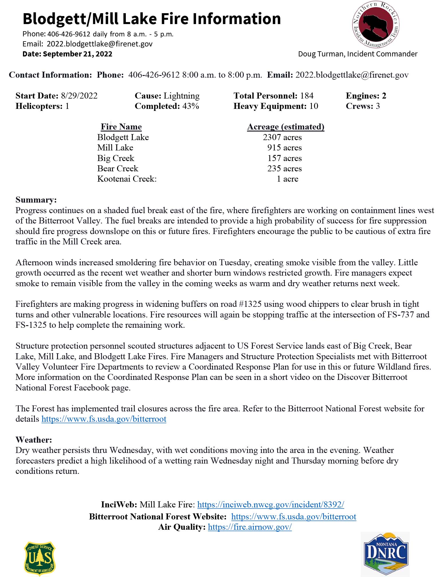
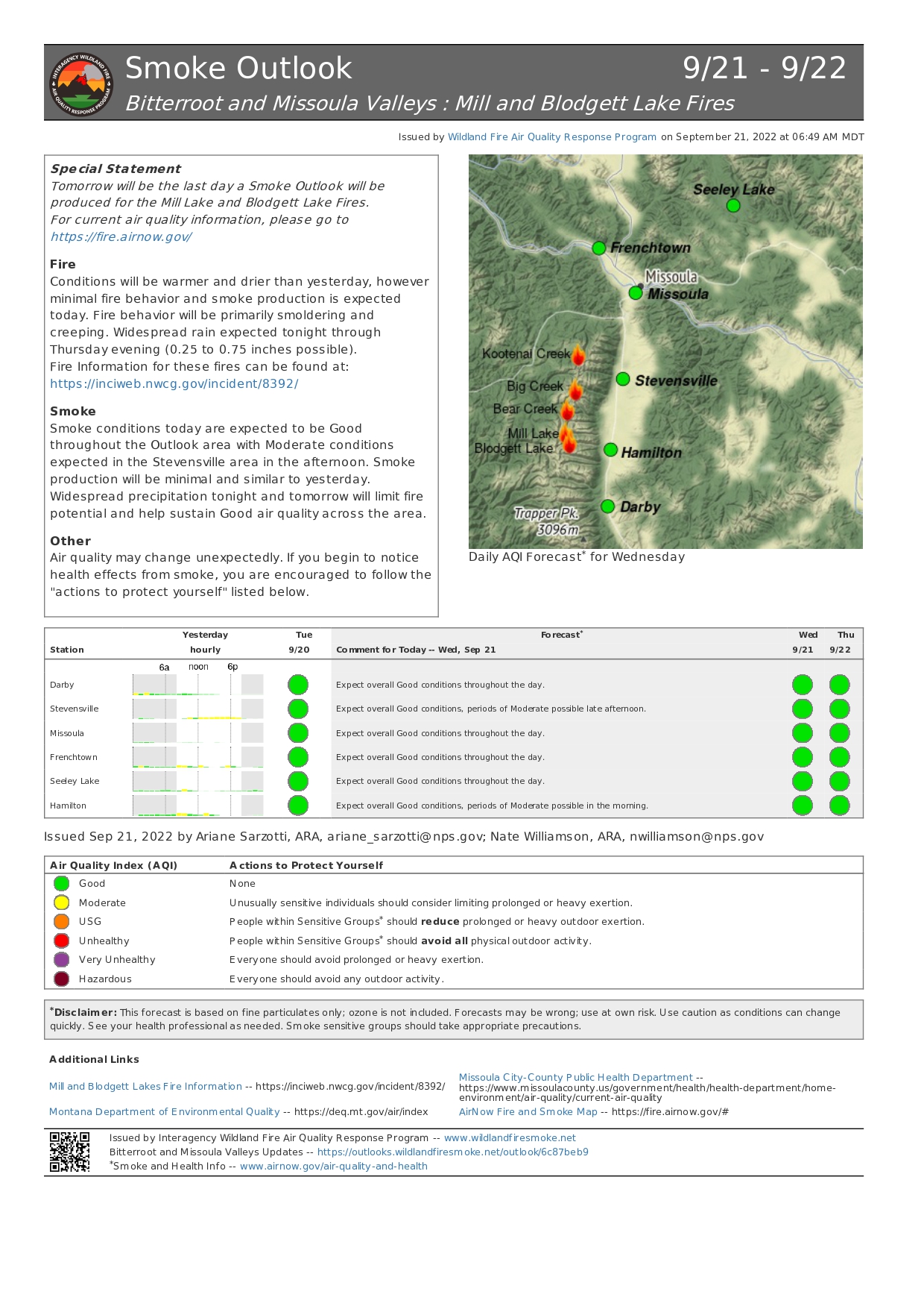
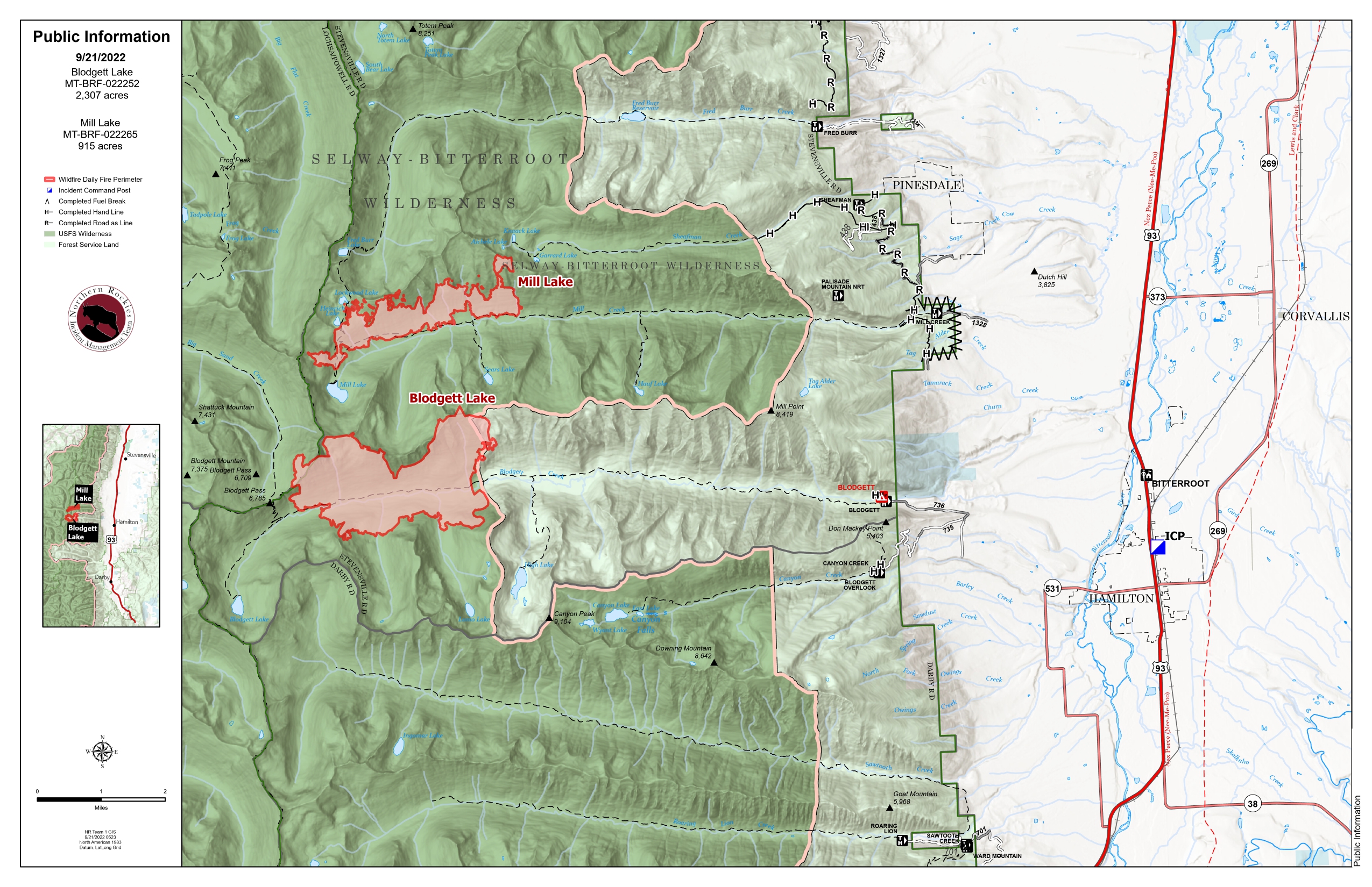
Mill Lake Blodgett Lake Fires for Sept 21 2022
Related Incident: Mill Lake Fire
Publication Type: News
Fire Name Acreage (estimated)
Blodgett Lake 2303 acres
Mill Lake 913 acres
Bear Creek 234 acres
Kootenai Creek: 1 acre
Summary:
Progress continues on a shaded fuel break east of the fire, where firefighters are working on containment lines west of the Bitterroot Valley. The fuel breaks are intended to provide a high probability of success for fire suppression should fire progress downslope on this or future fires. Firefighters encourage the public to be cautious of extra fire traffic in the Mill Creek area.
Afternoon winds increased smoldering fire behavior on Tuesday, creating smoke visible from the valley. Little growth occurred as the recent wet weather and shorter burn windows restricted growth. Fire managers expect smoke to remain visible from the valley in the coming weeks as warm and dry weather returns next week.
Firefighters are making progress in widening buffers on road #1325 using wood chippers to clear brush in tight turns and other vulnerable locations. Fire resources will again be stopping traffic at the intersection of FS-737 and FS-1325 to help complete the remaining work.
Structure protection personnel scouted structures adjacent to US Forest Service lands east of Big Creek, Bear Lake, Mill Lake, and Blodgett Lake Fires. Fire Managers and Structure Protection Specialists met with Bitterroot Valley Volunteer Fire Departments to review a Coordinated Response Plan for use in this or future Wildland fires. More information on the Coordinated Response Plan can be seen in a short video on the Discover Bitterroot National Forest Facebook page.
The Forest has implemented trail closures across the fire area. Refer to the Bitterroot National Forest website for details https://www.fs.usda.gov/bitterroot
Weather:
Dry weather persists thru Wednesday, with wet conditions moving into the area in the evening. Weather forecasters predict a high likelihood of a wetting rain Wednesday night and Thursday morning before dry conditions return.
InciWeb: Mill Lake Fire: https://inciweb.nwcg.gov/incident/8392/
Bitterroot National Forest Website: https://www.fs.usda.gov/bitterroot
Air Quality: https://fire.airnow.gov/
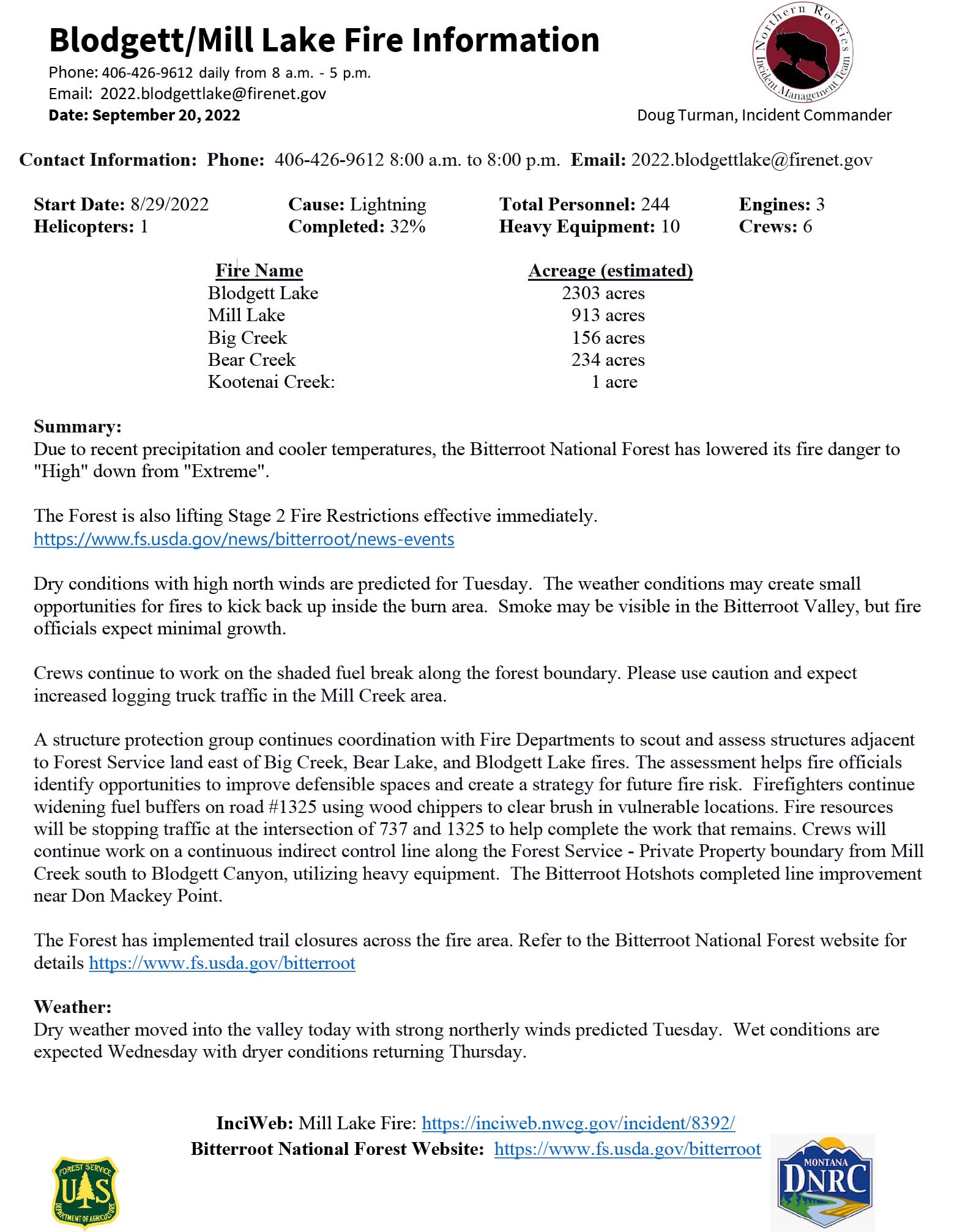
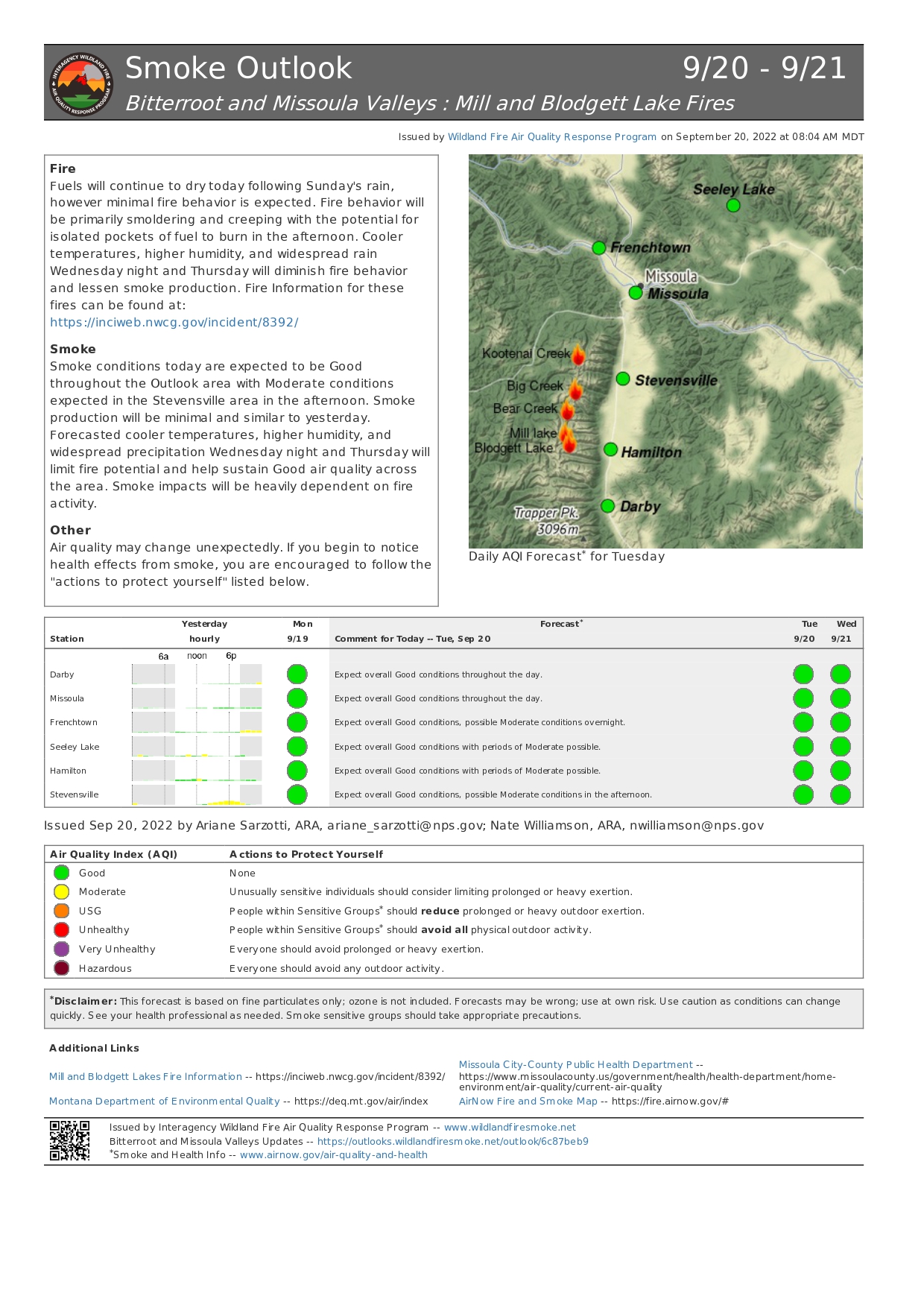
Mill Lake Blodgett Lake Fire Updates for Sept 20 2022
Related Incident: Mill Lake Fire
Publication Type: News
Fire Name Acreage (estimated)
Blodgett Lake 2303 acres
Mill Lake 913 acres
Big Creek 156 acres
Bear Creek 234 acres
Summary:
Due to recent precipitation and cooler temperatures, the Bitterroot National Forest has lowered its fire danger to "High" down from "Extreme".
The Forest is also lifting Stage 2 Fire Restrictions effective immediately. https://www.fs.usda.gov/news/bitterroot/news-events
Dry conditions with high north winds are predicted for Tuesday. The weather conditions may create small opportunities for fires to kick back up inside the burn area. Smoke may be visible in the Bitterroot Valley, but fire officials expect minimal growth.
Crews continue to work on the shaded fuel break along the forest boundary. Please use caution and expect increased logging truck traffic in the Mill Creek area.
A structure protection group continues coordination with Fire Departments to scout and assess structures adjacent to Forest Service land east of Big Creek, Bear Lake, and Blodgett Lake fires. The assessment helps fire officials identify opportunities to improve defensible spaces and create a strategy for future fire risk. Firefighters continue widening fuel buffers on road #1325 using wood chippers to clear brush in vulnerable locations. Fire resources will be stopping traffic at the intersection of 737 and 1325 to help complete the work that remains. Crews will continue work on a continuous indirect control line along the Forest Service - Private Property boundary from Mill Creek south to Blodgett Canyon, utilizing heavy equipment. The Bitterroot Hotshots completed line improvement near Don Mackey Point.The Forest has implemented trail closures across the fire area. Refer to the Bitterroot National Forest website for details https://www.fs.usda.gov/bitterroot
Weather:
Dry weather moved into the valley today with strong northerly winds predicted Tuesday. Wet conditions are expected Wednesday with dryer conditions returning Thursday.
InciWeb: Mill Lake Fire: https://inciweb.nwcg.gov/incident/8392/
Bitterroot National Forest Website: https://www.fs.usda.gov/bitterroot
Air Quality: https://fire.airnow.gov/