
Incident Publication
Burnt Peak and South Yaak Fires Community Meeting
Related Incident:
Publication Type: Announcement
Members of the public are invited to attend a community meeting on Monday, August 16, from 6:00 - 7:00 p.m., at Roosevelt Park under the pavilion near the fishpond. The event will also be livestreamed on Facebook from the U.S. Forest Service - Kootenai National Forest page.
Burnt Peak and South Yaak Fires 81621 Update
Related Incident:
Publication Type: News
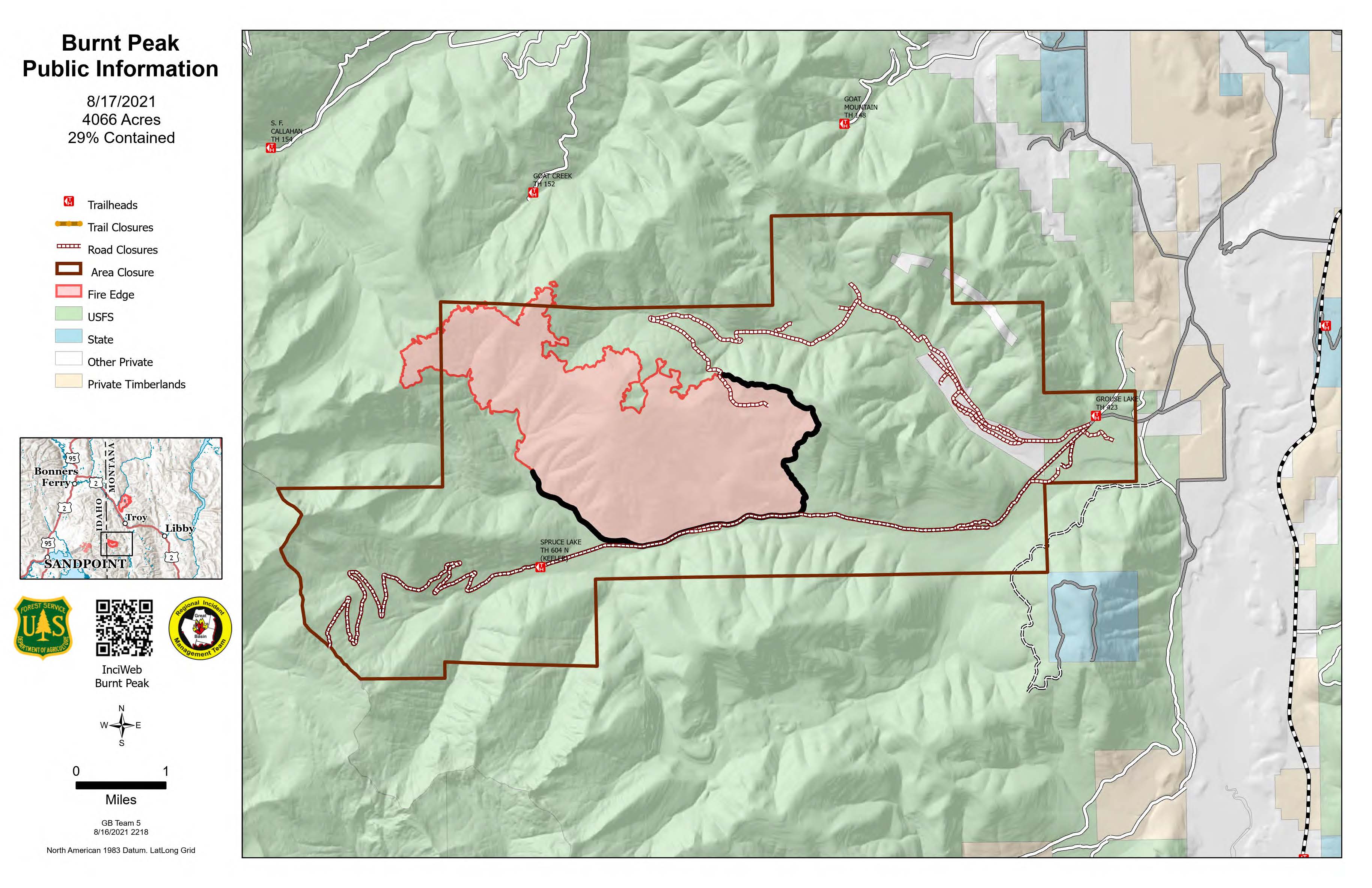
Burnt Peak and South Yaak Fires 81721 Update
Related Incident:
Publication Type: News
Weather – An upper low-pressure system pushing a cold front ahead of it arrived early this morning with light rain. Expect temperatures in the low 70s with 50% relative humidity in the valleys and cooler temps and higher humidity on ridgetops. Brisk northwest winds in the morning will shift to the northeast as the front passes through, bringing an 80% chance of precipitation and a slight possibility of a thunderstorm; precipitation could extend into Wednesday. Refer to https://www.airnow.gov/Troy for information on air quality in the Troy and Libby areas.
How to Thank a Firefighter
Related Incident:
Publication Type: Announcement
The incident management team for the Burnt Peak and South Yaak fires wants to sincerely thank the community for their expressions of support and thanks for the firefighters. For those who would like to have a tangible way to show thanks, we encourage you to consider giving to the Wildland Firefighter Foundation. The Wildland Firefighter Foundation's main mission is to help families of firefighters killed in the line of duty and to assist injured firefighters and their families. You can find out more at https://wffoundation.org.
Burnt Peak and South Yaak Fires 81821 Update
Related Incident:
Publication Type: News
Weather – Ridgetop winds will push yesterday’s wet weather out of the area through mid-day. Showers are expected to taper off to partly cloudy skies this evening. Anticipate light winds, high temperatures in the lower to mid-60s and relative humidity around 40% in the valleys, and upper 50s and 55% humidity on ridges.
Yesterday the Burnt Peak Fire received a total 1” of rain and the South Yaak Fire received .8” of rain. The moisture is expected to reduce surface fire spread until the weekend, although heavy fuels will continue to be consumed.
Burnt Peak Fire
InciWeb: https://inciweb.nwcg.gov/incident/7619/
A tactical pause due to weather allowed resources to be shifted to the Keeler Creek area where they will be the most effective in bolstering containment lines. Heavy equipment will improve work along the 404 Road today. Firefighters will continue with direct attack where available, based on weather conditions and safe access, heeding slick and muddy roads.
Evacuations - Residents in North Fork Keeler Creek are on pre-evacuation notice.
South Yaak Fire
InciWeb: https://inciweb.nwcg.gov/incident/7696/
Most of the heat continues to be scattered between Arbo and North Fork O’Brien Creeks, but was dampened little by yesterday’s rains. Active surface spread is not expected to occur until the weekend, after fuels dry out.
Mopping up and patrolling along Eastside Road will continue as roads improve and can be safely accessed. Slick roads hampered access yesterday, while cloud cover and weather grounded aerial resources. However, crews accessed the 2380 Road going direct along the fire’s edge and determined new alternate & contingency lines for holding the fire. Constructed dozer lines in contained portions of the fire will be sized up for future repair work. Closure area signage will be improved. An unmanned aerial system (UAS or “drone”) will fly within the fire perimeter near Kilbrennan Lake Road to view the status of a timber sale area on private lands.
Evacuations- Residents on Eastside Road, Kilbrennan Lake Road, Seventeen Mile Creek, and Sylvanite are on pre-evacuation notice. All residents should be ready to leave if evacuations become necessary. These area roads are not open to the public.
Closures- The Three Rivers Ranger District has several areas, roads, and trails closed or restricted for public safety due to fire management activities related to the Burnt Peak and South Yaak fires. Closure orders and maps may be viewed on the Kootenai National Forest web page https://www.fs.usda.gov/alerts/kootenai/alerts-notices.
Daily COVID screening measures are in place in fire camp to continue protecting firefighters and the local communities.
Evening Update for Burnt Peak and South Yaak Fires Aug 18 2021
Related Incident:
Publication Type: News
Fire behavior on the Burnt Peak and South Yaak fires was minimal today due to widespread rainfall received Tuesday. Hand crews were able to work on direct line construction in the Prospect Creek/Arbo Creek drainage. Slick and muddy roads hampered equipment from accessing some areas of the fires.
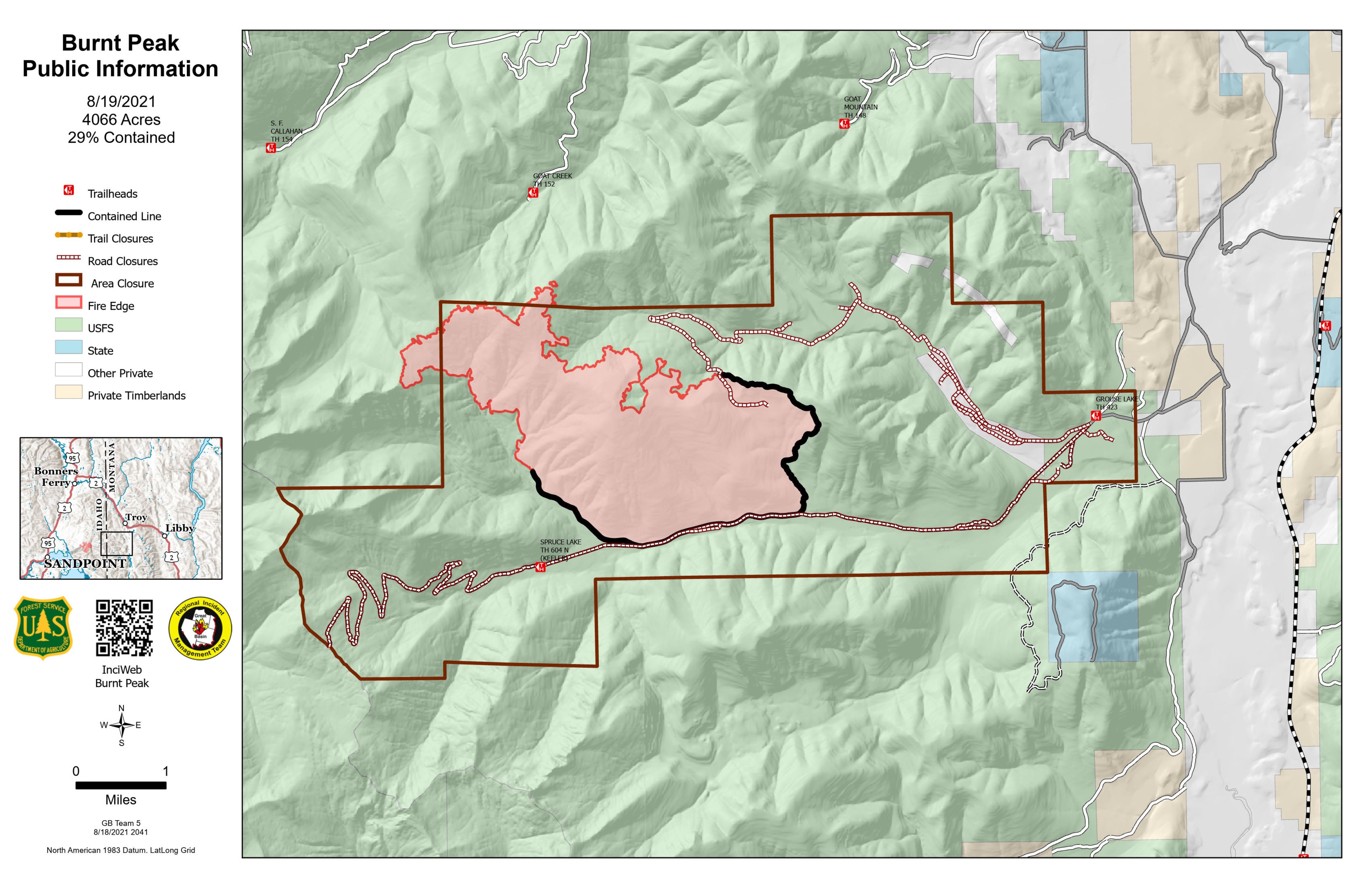
Burnt Peak and South Yaak Fires 81921 Update
Related Incident:
Publication Type: News
Facebook: https://www.facebook.com/kootenainf/
Weather – Warming temperatures continue into today, with expected highs in the low 80s across the valley and 70s mid-upper slopes. Light winds will be out of the west/northwest. Skies will be partly cloudy and dry today, though isolated showers may push back into the region later tonight.
Muddy roads will continue to delay the start of operations in some areas across the fires.
Burnt Peak Fire
InciWeb: https://inciweb.nwcg.gov/incident/7619/
Heavy equipment that arrived yesterday will construct the fuel break along the 404 Road up toward Goat Mountain. Resources will improve preparations and clean-up along Callahan Creek Road and begin assessing the Three-Mile Creek Road as a contingency line. Resources will continue staging water resources along existing contingency lines. Direct line construction, including handline, dozer line and saw lines will advance along the road in the North Fork of Keeler Creek. Crews will spend time reinforcing previous work along the 4506 Road to complete that portion of containment line to the 4542 Road in the West Fork of Keeler Creek.
Evacuations - Residents in North Fork Keeler Creek are on pre-evacuation notice.
South Yaak Fire
InciWeb: https://inciweb.nwcg.gov/incident/7696/
High humidity and lower temperatures will continue to moderate fire behavior across most of the fire today. Active surface spread is not expected to occur until the weekend, after fuels dry out.
Mop up and patrol along Eastside Road will continue as roads improve and can be safely accessed. Engines will continue to patrol and secure containment lines along Kilbrennan Lake Road to O’Brien Creek. Crews in the Arbo Creek drainage will continue to construct direct and indirect containment lines. Planning for additional contingency work along roads outside of the active fire perimeter will continue while fire behavior is moderated by the cooler temperatures and higher humidity. Local resource Kootenai handcrew will continue direct line construction into the North Fork of O’Brien Creek. Operations will begin working on a repair plan for dozer line near the Yaak Mountain Lookout.
Evacuations- Residents on Eastside Road, Kilbrennan Lake Road, Seventeen Mile Creek, and Sylvanite are on pre-evacuation notice. All residents should be ready to leave if evacuations become necessary. These area roads are not open to the public.
Closures- The Three Rivers Ranger District has several areas, roads, and trails closed or restricted for public safety due to fire management activities related to the Burnt Peak and South Yaak fires. Closure orders and maps may be viewed on the Kootenai National Forest web page https://www.fs.usda.gov/alerts/kootenai/alerts-notices.
Daily COVID screening measures are in place in fire camp to continue protecting firefighters and the local communities.
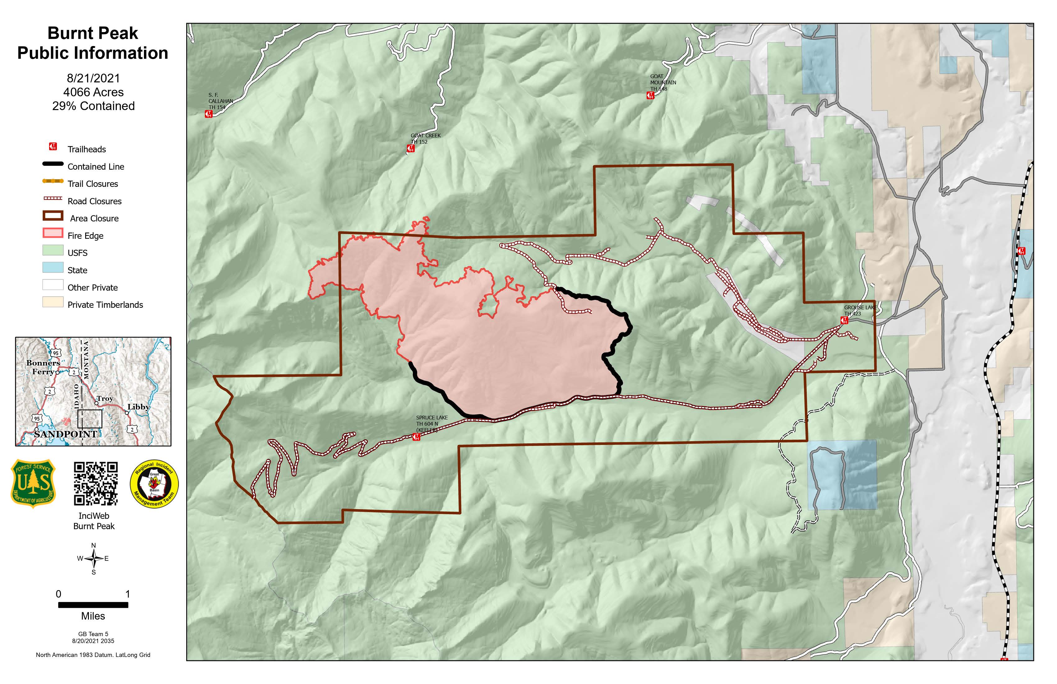
August 20 2021 Daily Update for Burnt Peak Fire
Related Incident:
Publication Type: News
Daily Update for Burnt Peak Fires
4066 Acres
29 percent contained
Weather – Heavy rains fell over the fire areas last night, accompanied by lightning. Today, partly cloudy skies will transition into mostly cloudy as scattered showers move into the area after noon. Temperatures will only reach the upper 60s today. Additional moisture and lower temperatures are expected tonight and into this weekend.
Work will continue on roads as alternate containment lines in the West Fork Keeler Creek drainage. Equipment will be moved to the Keeler-Rattle Road to begin work on a shaded fuel break. Resources will work on improving or maintaining conditions along Callahan Creek Road. They will also be scouting for routes between Callahan Creek Road and the fire’s northern edge where hand line could be built if crews become available in the coming days and weeks. Work continues in the North Fork Keeler Creek drainage as forces continue to improve roads up to Goat Mountain. Heavy equipment work with feller bunchers, masticators, skidders, etc. will continue on shaded fuel breaks along the 4576 Road in Surprise Draw.
Evacuations - Residents in North Fork Keeler Creek are on pre-evacuation notice.
Closures- The Three Rivers Ranger District has several areas, roads, and trails closed or restricted for public safety due to fire management activities related to the Burnt Peak and South Yaak fires. Closure orders and maps may be viewed on the Kootenai National Forest web page https://www.fs.usda.gov/alerts/kootenai/alerts-notices.
Daily COVID screening measures are in place in fire camp to continue protecting firefighters and the local communities.
August 21 2021 Daily Update for Burnt Peak Fire
Related Incident:
Publication Type: News
August 21, 2021 Daily Update
12,522 Acres
51 percent containment
Weather – Cloudy skies with showers likely, along with one or two thunderstorms. Temperatures will likely only reach the lower 60s today. Partly sunny with temperatures in the 70s on Sunday. Warmer and drier conditions are expected to return on Monday. The fire behavior analyst projects that it will take up seven days of warm and dry weather for the fire to return to active behavior; meanwhile, it continues to smolder in thick understory fuels.
Recent rains have reduced the need to keep pumps ready in Benning Creek and Callahan Creek, so they will be pulled for the time being, while the other hose and water infrastructure remains. Masticators are working to reduce vegetation and widen the corridor on Keeler-Rattle Road and create a shaded fuel break. Feller bunchers finished work on the fuel break along 404 Road and will be moving to 4576 Road to create another shaded fuel break near Surprise Draw.
Closures – The Three Rivers Ranger District has several areas, roads, and trails closed or restricted for public safety due to fire management activities related to the Burnt Peak and South Yaak fires. Closure orders and maps may be viewed on the Kootenai National Forest web page https://www.fs.usda.gov/alerts/kootenai/alerts-notices.
Pre-evacuation – Fire managers are coordinating with the Lincoln County Sherriff’s Office to reevaluate pre-evacuation status for residents near the fire perimeters.
Daily COVID screening measures are in place in fire camp to continue protecting firefighters and the local communities.
August 21 Burnt Peak and South Yaak Fires Evening Update
Related Incident:
Publication Type: Announcement
The Burnt Peak and South Yaak have measured over 1.6” of rain on parts of the fire areas since Thursday night. Crews, engines, and heavy equipment continue to make progress on direct and indirect fireline as well as alternate containment lines and shaded fuel breaks when and where road conditions allow. We also got the good news that the Lincoln County Sheriff’s Office lifted all pre-evacuation notices across the area.