
Incident Publication
Burnt Peak and South Yaak Fires 872021 Update
Related Incident:
Publication Type: News
Gusty winds return both Saturday and Sunday. Chances for rain are on the rise starting Saturday night and persisting through Sunday night. Many locations are expected to see a wetting rain through this period, meaning at least one tenth of an inch. Sunday looks to be the coolest day before a warming and drying trend starts Monday.
Burnt Peak Fire
The regional lack of hand crews dictates a strategy of indirect fire line operations where fire personnel can make the most impact. A series of fuel breaks along forest road systems will provide layers of protection and opportunities to fight the fire. Heavy equipment work continues along Callahan Creek Road to the base of McConnell Mountain that should be completed in a couple of days. The fire team is patrolling the Goat Creek drainage west of Survey Mountain and using equipment in West Fork Keeler Creek such as feller bunchers (that gather and cut a tree before felling it) and masticators (machines that grind up trees).
Fire behavior may increase today given the forecasted ridge top winds in the mid-20 mph range. The weather may cause backing and uphill runs on the fire’s western and northwestern flanks, bringing significantly increased smoke into the town of Troy. Snags may increasingly fall across roads due to wind gusts.
Evacuations —Residences in North Fork Keeler Creek are on pre-evacuation notice. All area residents should be ready to leave if evacuations are necessary.
South Yaak Fire
Yesterday’s continued smoke cover reduced fire intensity though late afternoon winds caused crowning and torching of trees along the northwestern flank. Equipment redeployment began after containment line work wrapped up along the 17 Mile Creek subdivision. The roads north of the fire in the 17 Mile Creek area continue to be congested with public, logging operations, firefighters and heavy equipment. We encourage everyone to drive slowly and cautiously in the area because the sides of the roads have soft shoulders — be on the lookout for fallen trees.
Today, tactics include firing operations and suppressing spot fires along the growing northeastern flank into the Arbo Creek drainage and onto the slopes of Feeder Mountain. There is another day ahead of chipping operations along the 752 road, to use as an indirect fire line. Fire managers plan to increase water bucket drops as safe flying conditions permit. We anticipate Sunday’s arrival of an Unmanned Aerial System team. It will bring drones capable of dropping ping pong ball-sized plastic spheres that ignite targeted ground fuels and help create fuel breaks.
Evacuations — There are mandatory evacuations for all residences on East Side Road and Kilbrennan Lake Road. Residences in Pine Creek, 17 Mile Creek, and Sylvanite are on pre-evacuation notice.
Burnt Peak and South Yaak Fires 882021 Update
Related Incident:
Publication Type: News
Weather — Cooler temperatures and a threat of showers and thunderstorms is expected Sunday afternoon and evening. Winds of 14-16 mph are expected on ridgetops. Winds will decrease as the system passes. Cooler temperatures will continue into the evening hours. Monday will bring warmer temperatures and lower daytime humidity as high pressure builds.
Yesterday, prep work on the west side of McConnell Mountain was completed. Today, fire activity is expected to be minimal due to last night’s rain. Prep work will continue along Callahan Creek Road for 2-3 days to tie into the Callahan Fire burn scar. The 414 Road is temporarily closed to public access due to heavy equipment working in this area.
Evacuations —Residences in North Fork Keeler Creek are on pre-evacuation notice. All area residents should be ready to leave if evacuations are necessary.
South Yaak Fire
Yesterday, fire activity was most active on the northeastern and eastern sides before rainfall. Short-range spotting contributed to fire spread. Firefighters completed the last remaining section of fire line south of the intersection of Eastside and Kilbrennan Lake Roads. A night shift was added to monitor any fire activity.
Today, crews will continue mopping up and gathering hose and equipment from the Kilbrennan Lake Road to be used in other areas. Brushing and chipping road prep will continue on the Eastside and 752 Roads. A drone will be available to assist with back burning where needed by dropping ignition fuels encased inside small plastic spheres.
Road safety is a concern after last night’s rain. Roads will be slick and the possibility of rollouts increase. We ask that everyone drive cautiously.
Evacuations — There are mandatory evacuations for all residences on East Side Road and Kilbrennan Lake Road. Residences in Pine Creek, 17 Mile Creek, and Sylvanite are on pre-evacuation notice.RoadTrail Restrictions Burnt Peak Fire D04076S21
Related Incident:
Publication Type: Closures
As of August 8, 2021, Closure Order D04-076-S-21 is now in effect on the Three Rivers Ranger District for the Callahan Creek Road #427 and Callahan Historic Trail #153.
Burnt Peak and South Yaak Fires 892021 Update
Related Incident:
Publication Type: News
Weather — Sunday was a cool and damp day around the incident with scattered showers and a couple rumbles of thunder nearby. Showers wrapped up Sunday night and temperatures plummeted as the clouds broke. For Monday and the remainder of the week, a warming and drying trend is expected under mostly sunny skies. Temperatures will rise back to above normal, likely hitting the triple digits in the lowlands, with valley humidity values dipping into the teens. Overnight temperature inversions are expected to develop keeping ridge humidity recoveries much lower than the valleys.
Yesterday, rain was scattered, only reaching isolated portions of the fire. Fire behavior was minimal with creeping, backing, and most activity occurred in the Survey Mountain/Benning Creek drainage/Keeler Creek drainage areas.
Today, prep work including chipping and falling dead trees will occur along Callahan Creek Road. Firefighters will identify areas for repair work east of the fire. The 414 Road is temporarily closed to public access due to heavy equipment working in this area. An Unmanned Aircraft System (UAS) operation will be dropping ignited plastic spheres on the northwest side of the fire to align unburned sections of the fires edge for easier access for firefighters.
Closures — As of August 8, 2021, Closure Order D04-076-S-21 is now in effect on the Three Rivers Ranger District for the Callahan Creek Road 427 and Callahan Historic Trail 153. The restriction is in place for public safety due to fire management activities related to the Burnt Peak Fire: www.fs.usda.gov/Internet/FSE_DOCUMENTS/fseprd938562.pdf
Evacuations — Residences in North Fork Keeler Creek are on pre-evacuation notice. All area residents should be ready to leave if evacuations are necessary.
South Yaak Fire
Yesterday, minimal fire behavior with creeping, backing, and slow upslope movement occurred on the northeastern and eastern portions of the fire.
Today, firefighters will work on firing a section of unburned fuel on the northwest edge of the fire, to prevent spotting across the Eastside Road. Heavy equipment will prepare indirect line along the O'Brien Road on the east and south sides of the fire. Construction on the fuel break south of Seventeen Mile Creek developments will also continue. Firefighters will remove some of the pumps and hose from the Kilbrennan Lake Road.
Evacuations — Effective today, Monday, 8/9/2021, the Lincoln County Sheriff’s Office is rescinding the evacuation order for Kilbrennan Lake Road and Eastside Road. These areas have been downgraded to a Pre-Evacuation Warning status.Burnt Peak and South Yaak Fires 8102021 Update
Related Incident:
Publication Type: News
Today will see increased winds out of the west, with gusts up to 20 mph. Temperatures are expected to climb back above normal with the valleys approaching the triple digits later in the week. Humidity values will also fall back into the teens causing all moisture from the last rainfall to evaporate quickly. Temperature inversions are expected to form each night leading to warmer temperatures on the ridges and only moderate humidity recovery.
Burnt Peak Fire
Yesterday, fire behavior was moderate with the most activity observed on the west and northwest edge of the fire perimeter around Survey Mountain and Benning Creek. An Unmanned Aircraft System (drone) helped conduct firing operations in this area. If conditions allow, firing operations will continue today to help remove unburned fuel down to the 4509 Road.
Crews finished removing hose and all other equipment from the North Fork Keeler Creek area. Today, crews will patrol the contingency line prepped east of the fire perimeter and remove snags that have the potential to fall. Vegetation clearing along the Callahan Creek Road will also continue today. For public safety, the Callahan Creek Road 427 and Callahan Historic Trail are closed as there is a lot of heavy equipment working along this route.
Evacuations — Residences in North Fork Keeler Creek are on pre-evacuation notice. All residents should be ready to leave if evacuations are necessary.
South Yaak Fire
Yesterday, fire was most active on the north side as it continues to back down into Arbo Creek. Heavy equipment completed clearing vegetation along the East Side Road between Yaak Falls and the junction with Kilbrennan Lake Road. Residents began returning to previously evacuated areas. Engines will continue to patrol and mop up hotspots along the East Side Road and Killbrennan Lake Road to maintain containment lines.
Evacuations — Residences on East Side Road, Kilbrennan Lake Road, 17 Mile Creek, and Sylvanite are on pre-evacuation notice. All residents should be ready to leave if evacuations are necessary.Burnt Peak and South Yaak Fires 8112021 Update
Related Incident:
Publication Type: News
Great Basin Incident Management Team #5 will assume command of both the Burnt Peak and South Yaak Fires tomorrow, August 12, 2021 at 6am. There is no change in acres because an infrared flight was not available last night to measure the active fire perimeter.
Weather — While clouds were present yesterday, the warming and drying trend was on display as temperatures were up a fair amount and humidity down in comparison to Monday. Friday and Saturday currently look to be the warmest days of the week with highs in the triple digits for the lowlands and humidity values plummeting into the teens. Changes are in store for the beginning of next week, deviating from the hot and dry pattern currently encompassing the region.
Yesterday, fire behavior was minimal to moderate with backing, flanking and slow upslope spread over much of the fire area. Most activity occurred in the Survey Mountain and Benning Creek drainage areas and has potential for moving towards Lafoe mountain. Firefighters managed this side of the fire by burning towards the 4509A road.
Today, heavy equipment will continue work on the Callahan Creek 414 and 427 roads, chipping and falling dead trees. East of the fire, firefighters will fall hazard trees.
Closures — As of August 8, 2021, Closure Order D04-076-S-21 is now in effect on the Three Rivers Ranger District for the Callahan Creek Road 427 and Callahan Historic Trail 153. The restriction is in place for public safety due to fire management activities related to the Burnt Peak Fire: www.fs.usda.gov/Internet/FSE_DOCUMENTS/fseprd938562.pdf
Evacuations — Residences in North Fork Keeler Creek are on pre-evacuation notice. All area residents should be ready to leave if evacuations are necessary.
South Yaak Fire
Yesterday, fuel reduction work continued on Eastside Road north of Yaak Falls. On the west side of the fire, steep terrain caused burning debris to rollout downhill from the fire as crews worked along Eastside road.
Today, firefighters will continue construction on the fuel break south of 17 Mile Creek developments and along the Eastside Road. On the northwest side of the fire, an Unmanned Aircraft System (drone) will be dropping ignited plastic spheres to align unburned sections of the fires edge if conditions permit.
Evacuations — Residences on East Side Road, Kilbrennan Lake Road, 17 Mile Creek, and Sylvanite are on pre-evacuation notice. All residents should be ready to leave if evacuations are necessary.
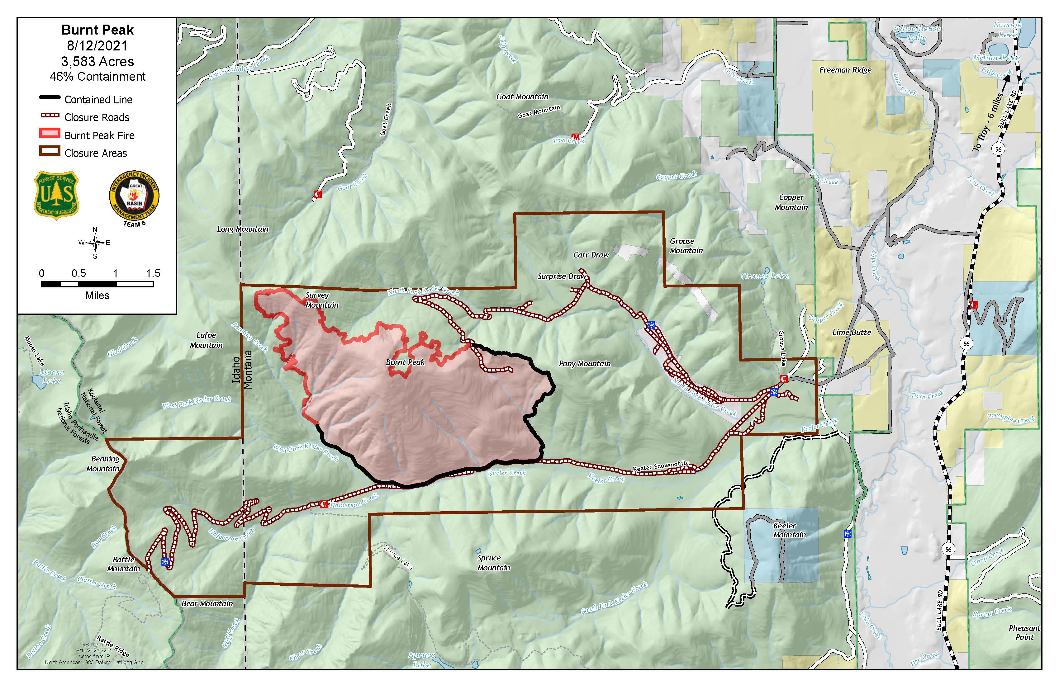
Burnt Peak and South Yaak Fires 81221 Update
Related Incident:
Publication Type: News
Great Basin Incident Management Team #5 under Incident Commander Sam Hicks took command of both the Burnt Peak and South Yaak Fires today at 6 a.m.
Burnt Peak Fire
Evacuations — Residences in North Fork Keeler Creek are on pre-evacuation notice. All area residents should be ready to leave if evacuations are necessary.
South Yaak Fire
Firefighters continued construction on the fuel break south of Seventeen Mile Creek developments and along the Eastside Road yesterday. The fire produced moderate amounts of smoke in the afternoon.
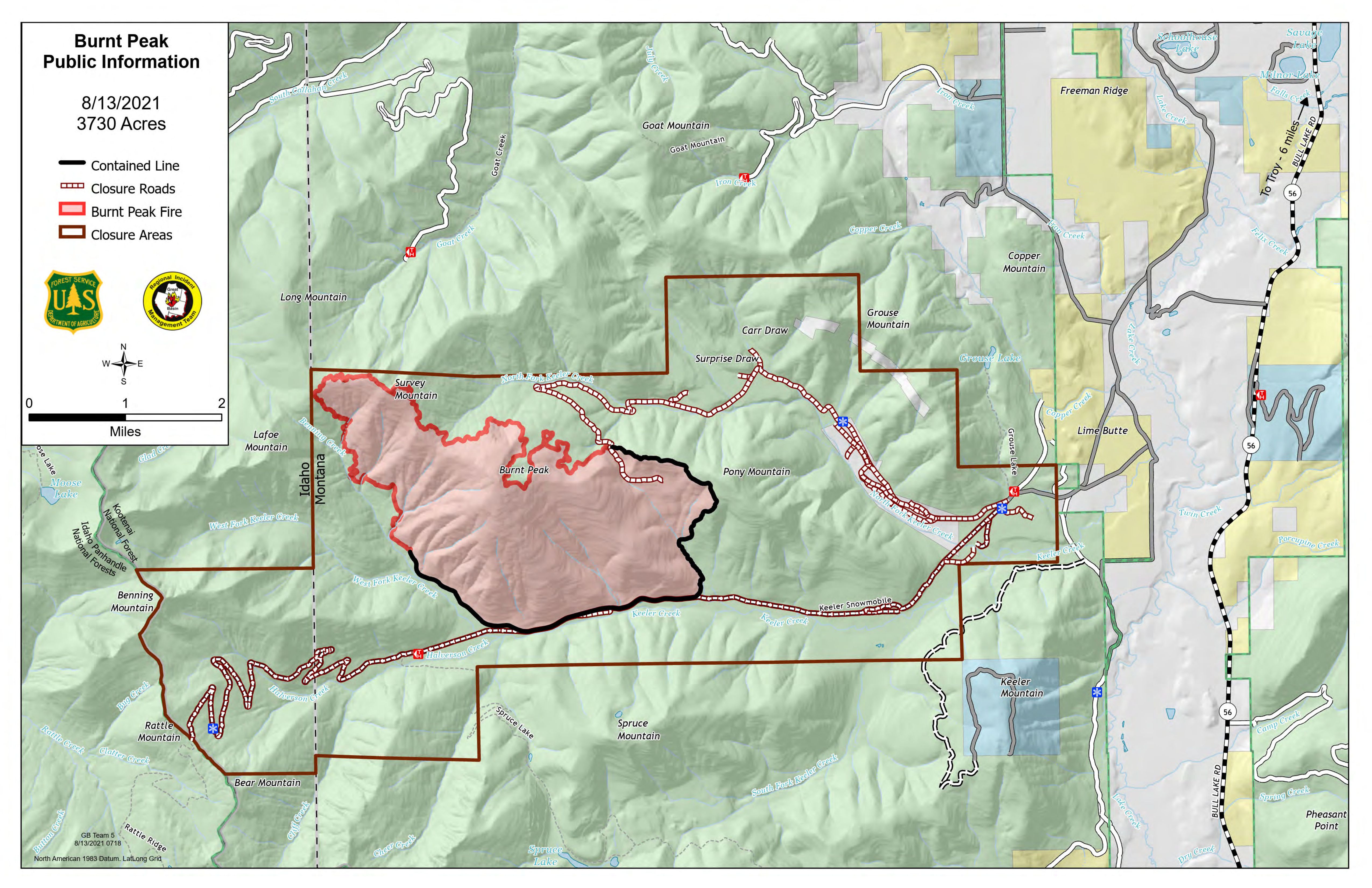
Burnt Peak and South Yaak Fires 81321 Update
Related Incident:
Publication Type: News
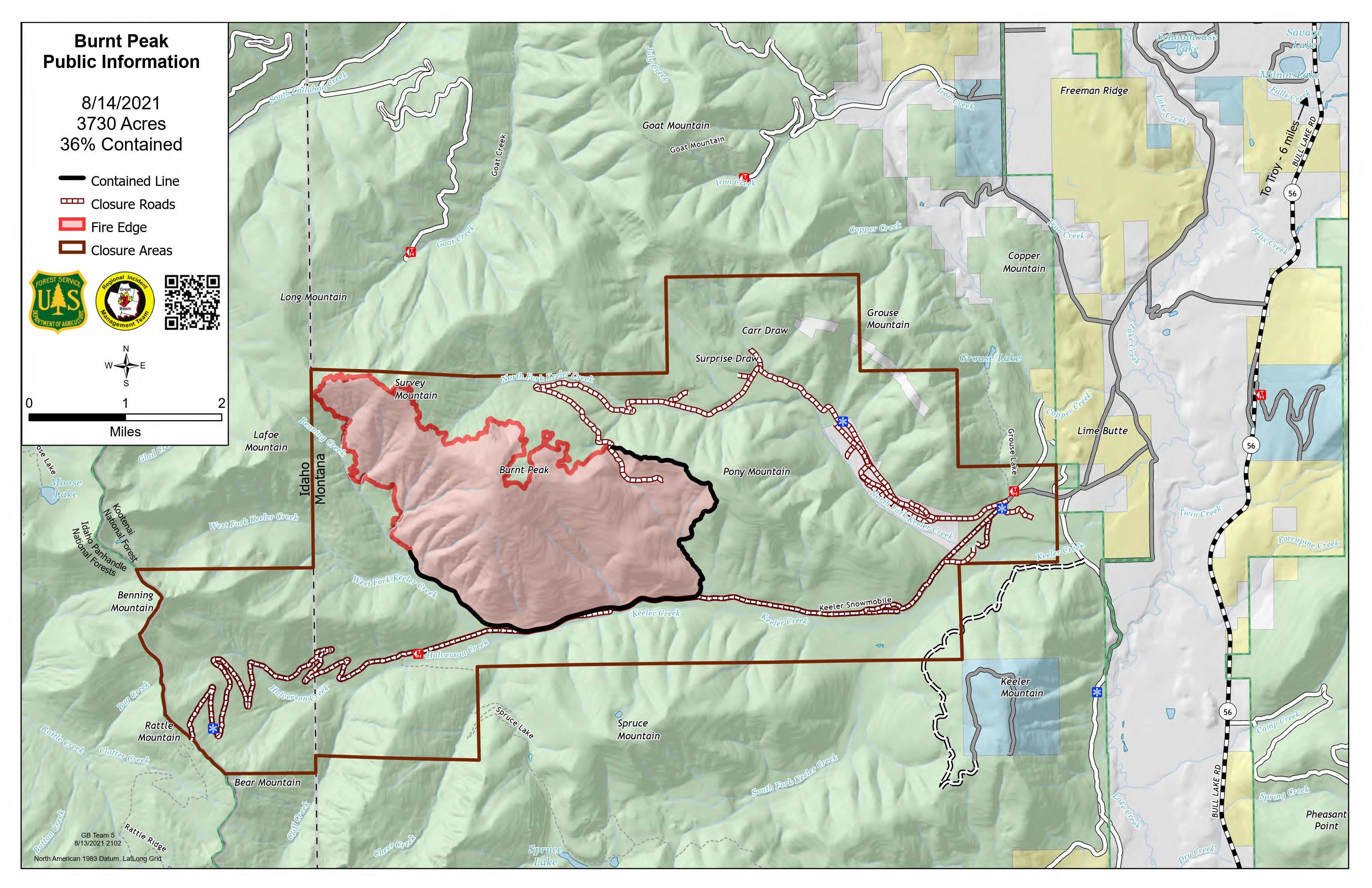
Burnt Peak and South Yaak Fires 81421 Update
Related Incident:
Publication Type: News
Burnt Peak and South Yaak Fires 81521 Update
Related Incident:
Publication Type: News
The fire was active in the Benning Creek drainage yesterday, crossing the east fork and advancing toward the 4542 Road. Today, firefighters will be reinforcing the road to slow spread to the west. The north edge continued to back down the slope toward North Fork Keeler Creek where firefighters are prepared to hold the fire at 404C Road. Along Callahan Road, crews will be placing pumps and hose lays for future use. As the hot and dry weather continues through today, the uncontained fire perimeter may expand toward the north.
On Saturday firefighters worked directly on several areas of the fire, securing containment east of Kilbrennan Lake Road and constructing handline towards the east up Prospect Creek. The north edge of the fire below Gunsight Mountain experienced increased burning yesterday, as well as the area above Arbo Creek. Progress was made in opening the 2380 Road to North Fork O’Brien Creek on the northeast side of the fire, where firefighters plan to continue constructing hand line up Prospect Creek today. Patrol and mop up of hot spots will continue along roads and containment lines.