
Incident Publication
Lick Creek Dry Gulch Fire Update for Saturday July 17 2021
Related Incident:
Publication Type: News
Lick Creek (Dry Gulch) Fire Quick Facts
Start Date: July 7, 2021
Approx. Size: 68,153 ac.
Cause: Lightning
Containment: 30%
Incident Commander: Randy Johnson, Pacific Northwest Team 3
Total Personnel: 611
Location: Approximately 2 miles SW of Asotin, WA
Resources:
14 Crews
58 Engines
11 Dozers29 Water Tenders
1Mastecator
Lick Creek (Dry Gulch) Fire Update - Saturday, July 17, 2021
The community fire briefing that took place yesterday at the Asotin County Fire Station in Clarkston was well attended. Representatives of local, state, and federal authorities involved in managing the fire updated the public on the incident situation.
Current Situation: Firefighters finished the last two miles of ignition on primary containment line and added depth along the southwest side of the fire. Aerial ignition was an important component of yesterday’s successful operations. The goal was to strengthen the existing containment lines. This strategy reduces the potential risk of fire spread in anticipation of warmer and drier conditions over the remainder of the summer. This short video explains how the plastic sphere dispensing system works for aerial ignition www.youtube.com/watch?v=3iPNOw-oQgo.
Today’s Activities: Crews will focus on mopping up containment lines around the fire perimeter. The fire has slowed down to creeping and smoldering with potential for more fire activity at higher elevations. If smoke clears and visibility improves, helicopters will conduct arial ignition operations on the western side of the fire to improve containment lines. Structure protection teams are in place around the fire area including Rose Springs, Grouse Flats and Anatone area.
Firefighters continue to assist with containment efforts at the Elbow Creek Fire near Troy, Oregon.
Weather and Smoke Information: Light wind coming from the north and northeast is expected today. With only light wind, the smoke is likely to stay concentrated over the fire area. Lighter winds are not enough to push the smoke out of the area which can affect visibility and limit the ability to perform air operations. Smoke Information is available on the Washington Smoke Blog at: https://wasmoke.blogspot.com/
Evacuations: Evacuation levels have changed. Evacuation zones, and fire perimeter maps are posted on InciWeb at https://inciweb.nwcg.gov/incident/7615.
Closures: All Forest Service lands, roads, and trails within the Umatilla National Forest are closed. The objective of the closure is to proactively protect public and firefighter safety as the assigned resources continue to actively suppress large wildfires on the forest. A full Forest closure means that the public is prohibited from entering any part of Umatilla National Forest at any time, including National Forest lands, roads, trails, and recreational facilities. Access on county, state or federal roadways will still be open. For more information visit the Umatilla National Forest website at www.fs.usda.gov/Internet/FSE_DOCUMENTS/fseprd931174.pdf.
ADDITIONAL FIRE INFORMATION:
Fire Information: 509-780-6238
InciWeb: inciweb.nwcg.gov/incident/7615/Facebook: Lick Creek Fire
Lick Creek Fire Update for Sunday July 18 2021
Related Incident:
Publication Type: News
Current Situation: The fire perimeter to the north and east, along the South Fork of the Asotin Creek and Peola road is contained and remains in patrol status. To the southeast, firefighters are continuing to find and secure small areas that are still smoking. More containment is anticipated in that area in the next couple days. On the south side, firefighters continue to establish more depth on containment lines. Local terrain driven winds continue to funnel embers up to half mile across the line. Embers from interior torching trees did cause some spot fires on the southwest edge of the fire yesterday. Most of the recent burnouts, by hand and by helicopter, have been along the road northwest of Misery warming shed. Securing these edges, lessens the potential for the fire to move to the south and west. Around the Clearwater Lookout crews, assisted by heavy machinery, are working to secure fireline.
An alternate, or contingency fireline is being constructed to the southeast, east of Big Butte Lookout. Contingency lines are secondary containment lines constructed as back up in case the fire escapes primary containment lines.
Today’s Activities: Crews will work on securing and strengthening containment lines. Aerial operations will resume this afternoon if smoke clears sufficiently to allow for safe visibility. Firefighters on the ground will be igniting unburned areas along the fireline with handheld drip torches. Crews on the Rose Springs area will continue chipping operations and start pulling out hose and other equipment. The fire has slowed down to creeping and smoldering with localized hot areas. The potential for fire spread or growth is minimal.
Oregon Department of Forestry Team 3, took command of Elbow Creek fire near Troy, Oregon today at 8 am. Firefighters that had assisted from Lick Creek Fire to help with initial response to Elbow Creek Fire will return to the Lick Creek Fire by the end of the day today.
Weather and Smoke Information: Temperatures will warm back into the 80s in the mountains and upper 90s for the lower valleys. Dry conditions are expected to persist. Smoke Information is available on the Washington Smoke Blog at: https://wasmoke.blogspot.com/
Evacuations: Evacuation levels have changed. Evacuation zones, and fire perimeter maps are posted on InciWeb at https://inciweb.nwcg.gov/incident/7615.
Closures: All Forest Service lands, roads, and trails within the Umatilla National Forest are closed. For more information visit the Umatilla National Forest website at www.fs.usda.gov/Internet/FSE_DOCUMENTS/fseprd931174.pdf.
ADDITIONAL FIRE INFORMATION:
Fire Information: 509-780-6238
InciWeb: inciweb.nwcg.gov/incident/7615/Facebook: Lick Creek Fire
Lick Creek Fire Update Jul 19 2021
Related Incident:
Publication Type: News
Current Situation: The fire perimeter to the north and east, along the South Fork of the Asotin Creek and Peola road is contained and remains in patrol status. To the southeast, established fireline was wind tested by strong northern winds picking up embers from some trees torching on the interior of the fireline. Crews continued to maintain and improve fireline in that area and will patroll during day and night operations. Firelines near the Cloverland snow park area and Forest Service road 43 continue to be improved and are on track to be put into a patrol status soon. The southwest line of the fire also received higher winds during the night creating spot fires that night crews were able to contain. Patrolling and gridding of the area will continue as fireline is improved and hotspots are identified. Gridding is the action of searching for a small fire by systematically traveling over an area on parallel courses or gridlines.
The west side of the fire has remained stable allowing for heavy machinery to move in to grade roads, improving access routes to that side of the fire. Alternate, or contingency firelines are still being constructed east of Big Butte Lookout and to the west near Clearwater Lookout. Contingency lines are secondary containment lines constructed as back up in case the fire escapes primary containment lines.
Due to historically high temperatures and dry fuel loads the crews will be on a red flag warning starting Monday afternoon through Wednesday morning when dry lighting and isolated thunderstorms are possible. This weather has the potential to create funneling and channeled winds that could blow embers over the fireline and create isolated torching of trees on the interior of the fireline.
The Umitilla National Forest has requested that PNW Team 3 also assume command of Green Ridge Fire which is southwest of Lick Creek Fire. Today Lick Creek fire managers will be on site at Green Ridge to gain situational awareness and implement a transition plan for Tuesday morning when PNW Team 3 will take responsibility for the Green Ridge fire.
Today’s Activities: Crews are securing and strengthening containment lines. Aerial operations will be conducting burnout as needed and reconnaissance flights to look for spot fires outside the contained fireline and identifying interior hotspots. Crews on the southern-most tip of the fire will grid burned areas looking for hotspots and are patrolling established firelines. The fire has slowed down to creeping and smoldering with localized hot areas with some minimal fire activity in unburned areas inside the fireline. The potential for fire spread or growth is minimal at this time. Crews will remain diligent as the possible thunderstorms move in creating wind that may pick up embers over established lines.
Weather and Smoke Information: Temperatures will warm back into the 80s in the mountains and upper 90s for the lower valleys. Dry conditions are expected to persist. Smoke Information is available on the Washington Smoke Blog at: https://wasmoke.blogspot.com/
Evacuations: Evacuation levels have changed. Evacuation zones, and fire perimeter maps are posted on InciWeb at https://inciweb.nwcg.gov/incident/7615.
Closures: All Forest Service lands, roads, and trails within the Umatilla National Forest are closed. For more information visit the Umatilla National Forest website at www.fs.usda.gov/Internet/FSE_DOCUMENTS/fseprd931174.pdf.
Evacuation Level Update Jul 19
Related Incident:
Publication Type: Announcement
Effective immediately, evacuation levels have been downgraded for the Lick Creek Fire. Both the Level 2 in the Cloverland area (Asotin Co.) and the Level 2 northwest of the fire in Garfield County have been downgraded to Level 1. The Level 2 evacuation south of the Lick Creek Fire in the Grouse Flats area remains in place.
Lick Creek Fire Update for Tuesday July 20 2021
Related Incident:
Publication Type: News
Lick Creek Fire Current Situation: A red flag warning remains in place with the possibility of scattered thunderstorms and dry lightning. The current fire activity has been slow creeping and smoldering with minimal torching of trees on the interior of the established fireline. The fire perimeter to the north and east, along the South Fork of the Asotin Creek and Peola road is contained and remains in patrol status. To the south, southwest, and west sides of the fire, crews continue to improve fireline; allowing the fire near the perimeter to naturally back off the containment line. Mop up operations are ongoing to secure the fire line even more. Mop up is the extinguishing or removing of burning material near control lines, felling snags, and trenching logs to prevent rolling after an area has burned, to make a fire safe to limit potential for escape, and to reduce residual smoke.
Today’s Activities for Lick Creek Fire: Crews will work on securing and strengthening containment lines while patrolling the perimeter. Aerial operations will conduct reconnaissance flights looking for spot fires and hotspots. Due to the recent lower fire activity, crews that had been working night shift will now be utilized as initial attack crews. These initial attack crews will be working in strategic locations around the fire perimeter near areas of concern in case of new starts from lighting. Pre-positioning initial attack crews reduces response time in the event that a lighting strike or other ignitions result in new fires in the area since the current environment has resulted in critically dry fuels.
Lick Creek Fire Update for Wednesday July 21 2021
Related Incident:
Publication Type: News
Lick Creek Fire Current Situation: The fire perimeter to the north and east along the South Fork of the Asotin Creek and Peola road is contained and remains in a patrol status. Fire activity has been minimal, with creeping and smoldering on the south and southwest sides, within established firelines.
Today’s Activities for Lick Creek Fire: Crews are mopping up and further securing containment lines around the perimeter of the Lick Creek Fire. There have been no spots outside the line over the past two days.
Jul 21 Initial Attack
Related Incident:
Publication Type: News
Some of the firefighters assigned to the Green Ridge and Lick Creek incidents are providing initial attack response for a small lightning caused fire this afternoon in the Slick Ear area. There is no threat at this time to structures in the vicinity.
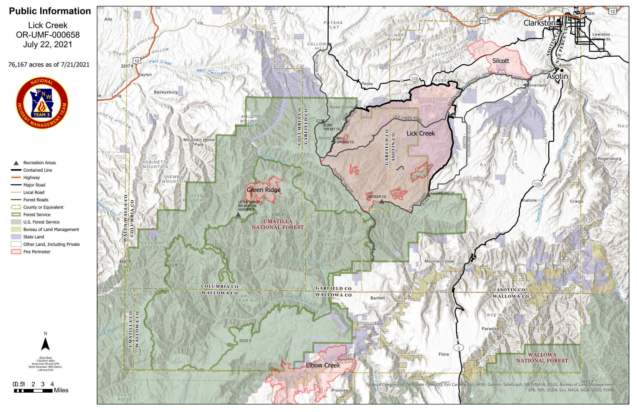
Lick Creek Fire Update for Thursday July 22 2021
Related Incident:
Publication Type: News
Lick Creek Fire Current Situation: There have been no spots outside the line over the past three days. The fire acreage change is due to interior burning in unburned pockets that are filling in naturally.
Today’s Activities for Lick Creek Fire: Crews continue to mop up around the fire perimeter and patrol for hot spots with aerial reconnaissance. Crews will continue to be prepared to respond for initial attack if new fires start in the area.
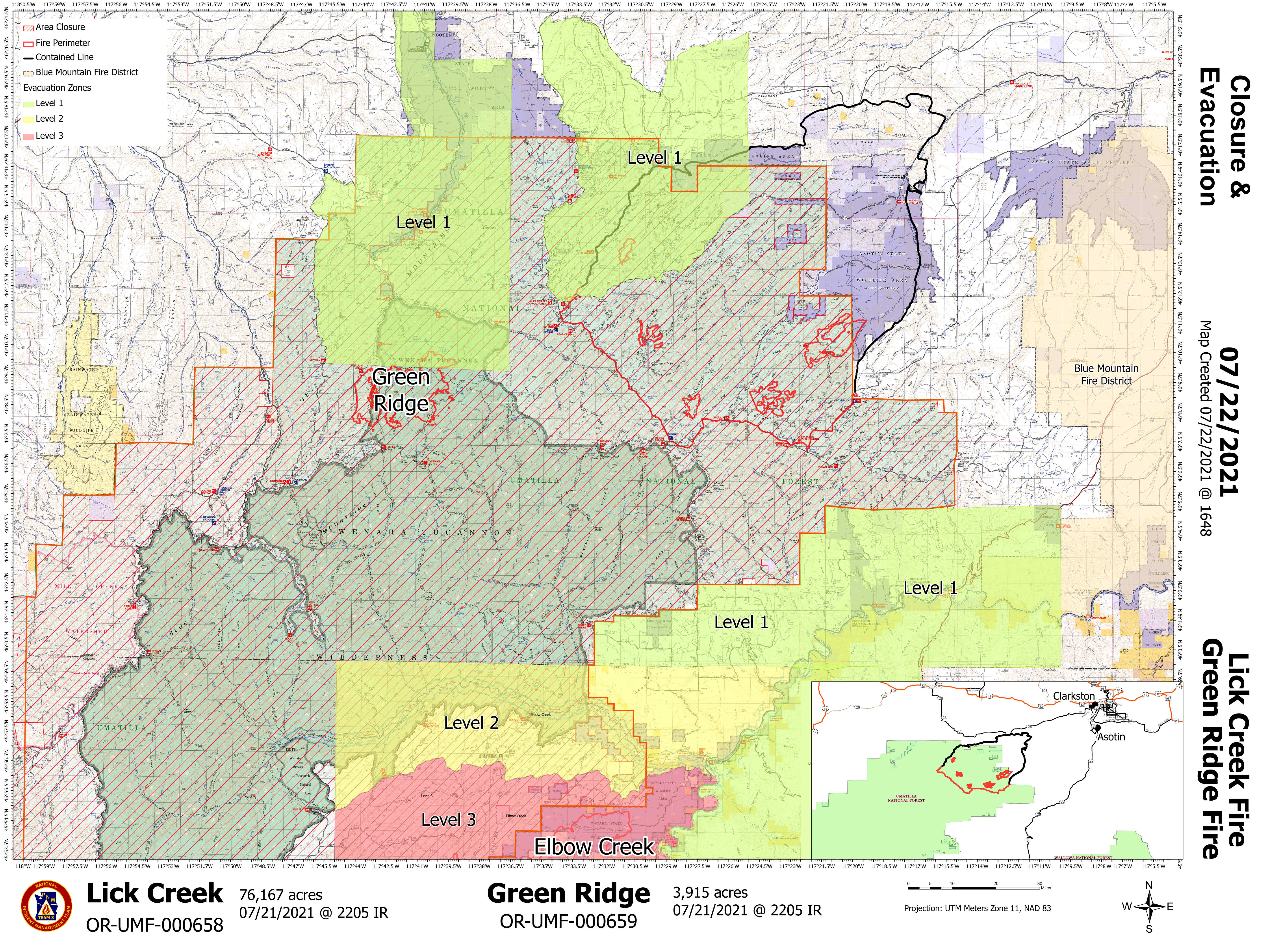
Evacuation Level Update July 22
Related Incident:
Publication Type: Announcement
Effectively immediately. Asotin County has downgraded the Grouse Flats evacuation zone from a Level 2 to a Level 1. The Level 1 Evacuation for Groverland and Anetone Evacuation Zones have been dropped. Garfield and Columbia Counties Level 1 Evacuation Zones remain in place.
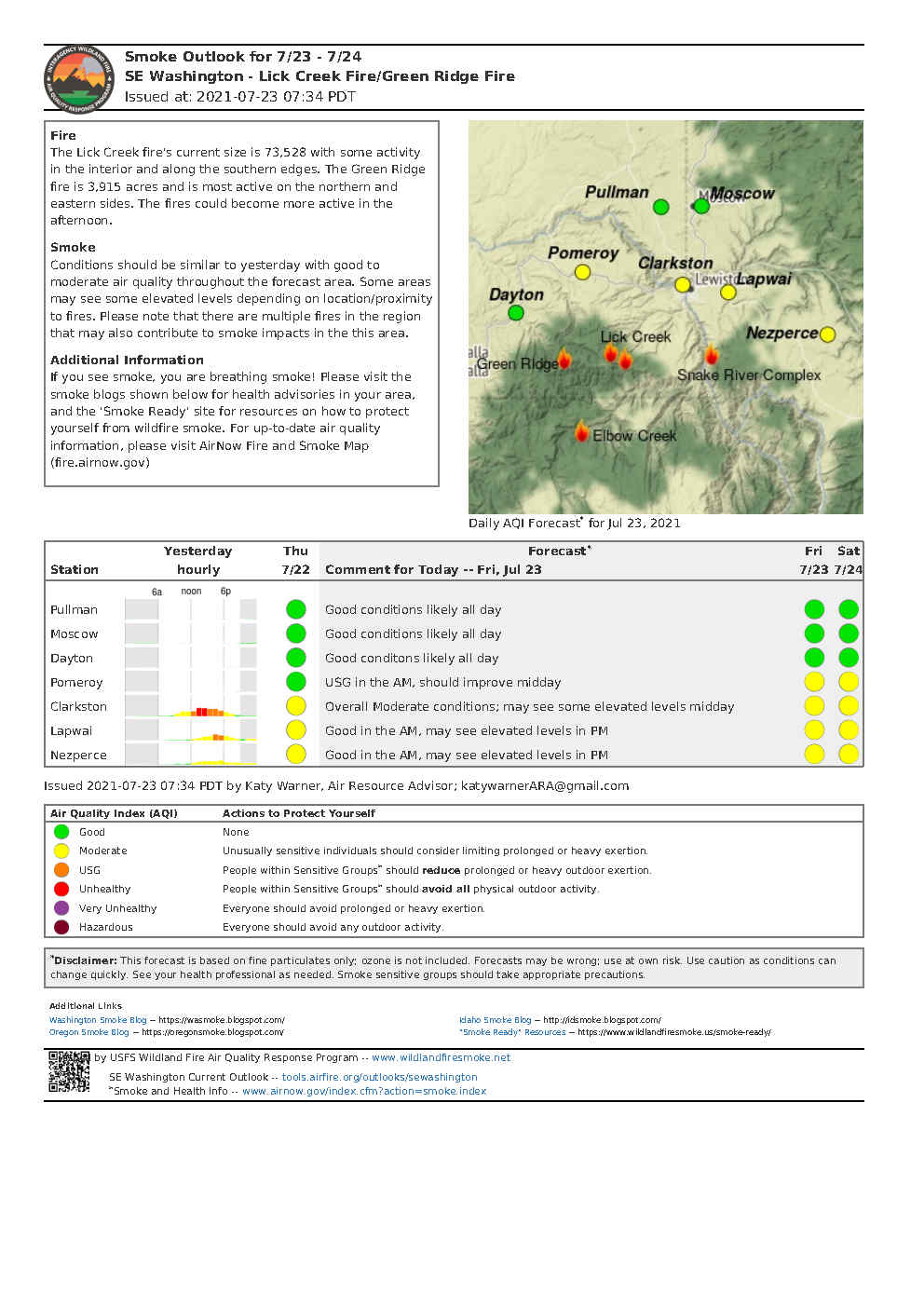
Smoke Outlook 723 724
Related Incident:
Publication Type: News
The Lick Creek fire's current size is 73,528 with some activity in the interior and along the southern edges. The fire could become more active in the afternoon.
Smoke Conditions should be similar to yesterday with good to moderate air quality throughout the forecast area. Some areas may see some elevated levels depending on location/proximity to fires. Please note that there are multiple fires in the region that may also contribute to smoke impacts in the this area.
If you see smoke, you are breathing smoke! Please visit the smoke blogs shown below for health advisories in your area, and the 'Smoke Ready' site for resources on how to protect yourself from wildfire smoke. For up-to-date air quality information, please visit AirNow Fire and Smoke Map (fire.airnow.gov)